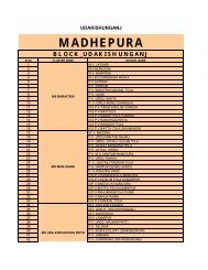
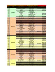
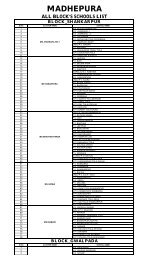
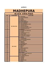
Block Shankarpur - Madhepura
Block Shankarpur - Madhepura
Block Shankarpur - Madhepura

Create successful ePaper yourself
Turn your PDF publications into a flip-book with our unique Google optimized e-Paper software.
<strong>Block</strong> <strong>Shankarpur</strong><br />
Name of the respondent:<br />
Total land area of the <strong>Block</strong>:<br />
Cultivable land (acres)<br />
A. <strong>Block</strong> Details<br />
Date: [16.09.2009<br />
Form No:<br />
Designation:<br />
<strong>Block</strong> name:<br />
Irrigated land area (acres)<br />
Number of Panchayats:<br />
No. of revenue villages:<br />
Land (please collect revenue block wise info also)<br />
Land use Forest Waste land<br />
Cultivable<br />
land<br />
Settlement<br />
area<br />
Total area<br />
Before flood (Area in acre) 2602.55 5002.75 17808.47 228.37+2.26 25644.40<br />
After flood (Area in acre) 907.70 5010.15 19103.22 228.37+2.26 25321.70<br />
Climate:<br />
Average annual temperature<br />
(in C)<br />
Average annual rainfall (in<br />
mm)<br />
Soil type<br />
Transportation linkages<br />
From <strong>Block</strong> HQ Railway Station State Transport Bus Stop Other<br />
Distance in Km<br />
Communication<br />
Category Mobile Radio Television Newspaper STD/PCO Post office Land line connection<br />
Nos. 4 2 11<br />
B. Demographic Details<br />
82519<br />
Population Male 44561 Literacy rate Male 23104<br />
Female 37952<br />
Female 11207<br />
Number of<br />
Children in the age of 0 to 6 Male 14122<br />
households<br />
Female 9431<br />
Occupation Agricultural Laborers Unemployed<br />
Structure workers<br />
Male<br />
Female<br />
Social groups<br />
Name of the<br />
caste/community/religion<br />
Number of households<br />
Total population<br />
Social structure<br />
Marriage pattern Female marriageable age: Male marriageable age:<br />
Festivals celebrated<br />
C. Housing details<br />
No of houses occupied<br />
No of house occupied<br />
No. of houses left vacant<br />
Housing typology<br />
Permanent Semi-permanent Temporary<br />
D. Social infrastructure<br />
Public<br />
amenities<br />
Distance<br />
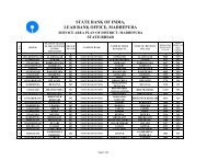
Anganwadi PDS Post office Bank Police Station Market (local)
(km)<br />
Number 74 22 11 01 01 03<br />
Schools<br />
No. of<br />
Student<br />
s<br />
No. of<br />
teacher<br />
s<br />
No. of<br />
classrooms<br />
No. of<br />
toilets<br />
Facilities<br />
available<br />
(yes/ no)<br />
Drinking<br />
water<br />
Library Playground Mid<br />
day<br />
meal<br />
Primary School 16828 218 86 23 30 12 56<br />
33/27<br />
Middle School 6000 160 85 36 18 12 17<br />
18/12<br />
High School 12 1200 21 14 1<br />
2 2 2<br />
Medical facilities Number Closest Distance Doctors/nurses Number of beds<br />
available<br />
Maternity home<br />
Nill<br />
Primary health center 01 414 NIll<br />
Dispensary 01 414 Nill<br />
Community health center<br />
Others Subcenter 05<br />
Are there any health related awareness programs Yes No<br />
If yes, which HIV/STD Birth control Maternal Care Girl child care Vaccination<br />
Frequency of yes yes yes Ten yes<br />
programs<br />
Any mid wife service available in the block Yes No NO<br />
If Yes than how far do you have to travel Is she available 24<br />
hours<br />
Yes<br />
yes<br />
No<br />
NO<br />
Major disease outbreak in the last five NO<br />
years<br />
Any type of vocational training institute in the block Yes No<br />
If yes, what type Distance of institute from the block Number of persons undergone training<br />
NO<br />
NO<br />
E. Physical infrastructure<br />
Water supply Stand post Well Ponds Bore well Individual Hand<br />
pumps<br />
Number<br />
Sanitation<br />
facilities<br />
Total number of<br />
toilets<br />
Number of soak<br />
pit toilets<br />
Number of pit<br />
latrines<br />
Open defecation<br />
(yes/ no)<br />
Number<br />
Storm Water Drains Open drain Closed drain None<br />
Length<br />
Electricity supply<br />
Source of electricity supply<br />
Hours of supply<br />
Street lights Yes No How many<br />
Roads Main Roads Access road to the settlements<br />
Width of road<br />
Material Mud Brick lined Tar Concrete Mud Brick lined Tar Concrete<br />
Length of road 21 km 21 km<br />
Type of roads Kutcha Pucca Kutcha Pucca<br />
Condition of road Good Average Bad Good Average Bad
List of proposed road related<br />
programs, fund amount and details<br />
F. Agriculture details (details at Panchayat block level)<br />
Type of crops grown Rice Wheat Maize Moong Bamboo Mustard Others<br />
Sowing season<br />
Harvest season<br />
Production (quintal)<br />
Present market price<br />
Nearest market (distance,<br />
block/town)<br />
Storage facilities at the<br />
block level, if any details<br />
Mechanized (tractor/power tiller)<br />
Agricultural equipments No. available in the block Rent [Rs. /day]<br />
Irrigation<br />
Present sources of irrigation<br />
(Type, amount of water,<br />
maintenance cost)<br />
Proposed irrigation projects<br />
(Type, amount of water,<br />
cost)<br />
Number of beneficiary<br />
Contribution from<br />
Panchayat<br />
Livestock details Cow Buffalo Jersey Cow Goat Hens Others<br />
Total number<br />
Cost of one Animal (Rs)<br />
Production from animal<br />
(milk, eggs etc)<br />
Income from animal<br />
Is there any veterinary services are available<br />
Yes If Yes, Location Distance<br />
No<br />
G. Industries<br />
Large scale<br />
industries<br />
Medium<br />
industry units<br />
Small scale<br />
units<br />
No. of units<br />
No. of Employees NO NO NO NO<br />
Source of Raw<br />
Materials<br />
Nearest market<br />
Training and<br />
research centers<br />
KEY ISSUES AND PROBLEMS<br />
Institutional<br />
/management<br />
Artisan based<br />
industries<br />
Agro-based<br />
industries<br />
Non-agro<br />
based<br />
industries
Fund related<br />
Program policy<br />
Quality and<br />
quantity of<br />
produce/<br />
efficiency of the<br />
sector<br />
Infrastructure status and future needs<br />
Availability Requirement Possible sources Alternatives<br />
Electricity<br />
Road<br />
connectivity<br />
Organized<br />
Market<br />
H. Informal Sector<br />
Type of<br />
sector<br />
Taxi<br />
driver<br />
Rickshaw<br />
diver<br />
No. of<br />
people<br />
involved<br />
I. Social awareness<br />
Tea stall<br />
Other<br />
Is there any SHG working in the block Yes No<br />
Type of SHG<br />
Number of<br />
Males/Females<br />
Composition Types of projects<br />
under taken<br />
Income<br />
Generated<br />
Budget<br />
utilization<br />
If there are more, use Separate sheet<br />
Are there any co-operatives in the block Yes No<br />
If yes, type of<br />
cooperative<br />
Products marketed<br />
Number of people<br />
Are there any NGOs working in the block Yes No<br />
Name<br />
Purpose<br />
Activity<br />
Government Schemes<br />
Housing sector<br />
Scheme available at the<br />
block level (Yes/No)<br />
If Yes, how many have<br />
been benefited<br />
Nature or benefit<br />
Credit-cum-Subsidy-Scheme for<br />
Rural Housing<br />
Indra Awas Yojana<br />
yes<br />
Economy<br />
Swarnjayanti Gram Swarojgar<br />
Yojana<br />
yes
Government Schemes<br />
Scheme available at the If Yes, how many have Nature or benefit<br />
block level (Yes/No) been benefited<br />
NREGA yes 13876 Labouring workers<br />
Infrastructure<br />
Water supply related<br />
Pradhan Mantri Gram Sadak<br />
Yojana<br />
Swasth Samiti Yojana (for<br />
toilets)<br />
yes 9 km M.V.D<br />
yes<br />
Health<br />
ASHA<br />
yes<br />
Polio Drops yes 17166 72040<br />
Social Welfare<br />
Girl Child education scholarship yes 6848 For reading.<br />
Mid-day meal yes 73 Miling<br />
Women empowerment<br />
J. Damage Assessment (details at Panchayat block level)<br />
Housing Damage Assessment<br />
Pucca Full Pucca Partial Kutcha Full Kutcha<br />
partial<br />
3KM 4KM 6KM 327 327<br />
IAY Partial IAY full Total No. of<br />
Damaged<br />
Houses<br />
Total No. of<br />
Houses<br />
Was there any community participation in housing reconstruction Yes No NO<br />
If yes, in what manner<br />
Livestock Damage Assessment<br />
Cow Buffalo Jersey Cow Goat Hens Others<br />
Number<br />
before<br />
floods<br />
Number<br />
after floods<br />
Agriculture Damage Assessment<br />
Cultivable Before<br />
Agricultural loss in terms of money<br />
area (sq.km) floods<br />
After floods<br />
Damage to storage facilities (number,<br />
amount needed for repair)<br />
Infrastructure Damage Assessment
Num<br />
ber<br />
Loca<br />
tion<br />
and<br />
dam<br />
age<br />
detai<br />
ls<br />
Road<br />
s<br />
Bridges Culverts Water<br />
bodies/<br />
ponds<br />
Schools<br />
Medical<br />
Facilities<br />
Community<br />
hall
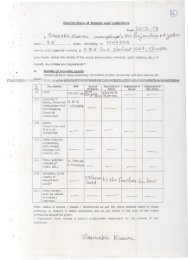
Checklist for data to be collected<br />
[If it cannot be collected get info on relevant authority that is in possession of these details]<br />
No. Item Yes No<br />
1. Form 9 on damages in the Kosi floods<br />
2. List of government lands with their uses<br />
3. List of roads and bridges with right of way, status of<br />
repair, etc<br />
4. Copy of infrastructure project sheets/DPRs being<br />
prepared/undertaken<br />
5. List of government programs and details of<br />
beneficiaries