environmental sciences research institute - University of Ulster
environmental sciences research institute - University of Ulster
environmental sciences research institute - University of Ulster

You also want an ePaper? Increase the reach of your titles
YUMPU automatically turns print PDFs into web optimized ePapers that Google loves.
As it is impossible to know in advance the magnitude, or rupture length, <strong>of</strong> the next earthquake, we simulate 4<br />
possibilities:<br />
1. The rupture terminates at the northern edge <strong>of</strong> the 1833 event, total length 210 km.<br />
2. The earthquake re-ruptures the area that failed in 1797, length 330 km.<br />
3. The event re-ruptures the regions that slipped in 1797 and 1833, length 630 km.<br />
4. In a worst case scenario, the rupture propagates south past Enggano Island for a total length <strong>of</strong> 840 km.<br />
A further unknown is the slip distribution <strong>of</strong> the future event and hence for each rupture length we model about 25<br />
different distributions. In total, then, we simulate about 100 possible earthquakes. For each simulated event, we calculate<br />
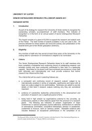
the sea-floor displacement and resultant tsunami. An example <strong>of</strong> the seafloor displacement and tsunami resulting from<br />
one simulated 630 km long earthquake is shown in Figure 2.<br />
Figure 2: Seafloor displacement (left) and tsunami along the coast <strong>of</strong> Sumatra (right) for one modelled earthquake. Note that<br />
the outer islands (e.g. Siberut) experience uplift in the event whereas the west coast <strong>of</strong> Sumatra drops by up to a meter. In this<br />
scenario, the maximum wave height is about 5 m with Padang, a city <strong>of</strong> 840,000 people, experiencing a 3 m high tsunami. The<br />
large variability in tsunami height along the coast line is largely controlled by local bathymetry.<br />
Our 100 simulations led to some remarkable results. The first is that initial peak <strong>of</strong> the tsunami comes ashore on the<br />
west coast <strong>of</strong> Sumatra approximately 33 minutes after the earthquake; regardless <strong>of</strong> the size <strong>of</strong> the earthquake. This is<br />
illustrated in Figure 3 where we show two very different simulated events yet the time series <strong>of</strong> the tsunamis are very<br />
similar.<br />
Our second major result is that, in the near-field, there is a one-to-one correspondence between the coastal displacement<br />
resulting from a particular earthquake and the maximum height <strong>of</strong> the tsunami triggered by it. This is shown in Figure<br />
4 where we plot the wave height vs. coastal displacement at 3 locations. This result suggests that single measure <strong>of</strong>, for<br />
example, the displacement <strong>of</strong> a seawall in an earthquake could be used to predict the height <strong>of</strong> the tsunami peak that<br />
will arrive 33 minutes later.<br />
<br />
22