Geological and Geochemical Mapping in Ethiopia
Geological and Geochemical Mapping in Ethiopia Geological and Geochemical Mapping in Ethiopia
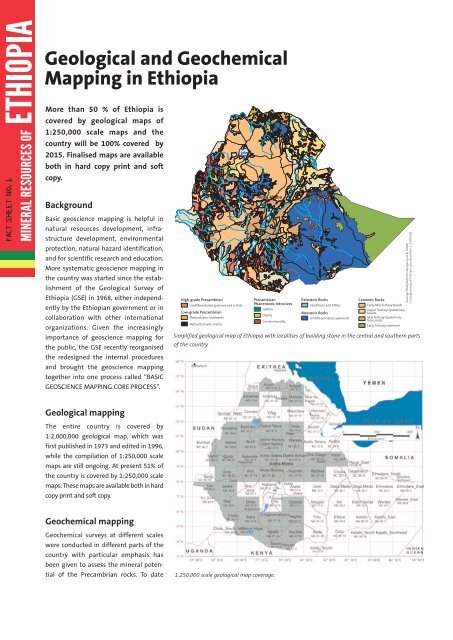
EthiopienFS_MAPPING_Ethiopia 10/8/10 2:35 PM Page 1 Geological and Geochemical Mapping in Ethiopia MINERAL RESOURCES OF More than 50 % of Ethiopia is covered by geological maps of 1:250,000 scale maps and the country will be 100% covered by 2015. Finalised maps are available both in hard copy print and soft copy. Background Basic geoscience mapping is helpful in natural resources development, infrastructure development, environmental protection, natural hazard identification, and for scientific research and education. More systematic geoscience mapping in the country was started since the establishment of the Geological Survey of Ethiopia (GSE) in 1968, either independently by the Ethiopian government or in collaboration with other international organizations. Given the increasingly importance of geoscience mapping for the public, the GSE recently reorganised the redesigned the internal procedures and brought the geoscience mapping together into one process called “BASIC GEOSCIENCE MAPPING CORE PROCESS”. High-grade Precambrian Undifferentiated gneisses and schists Low-grade Precambrian Metavolcano-sediments Metaultramafic-mafics Lake Tana Addis Ababa Precambrian Phanerozoic Intrusives Gabbro Diorite Granite-tonalite Paleozoic Rocks Sandstone and tillites Mesozoic Rocks Undifferentiated sediments Cenozoic Rocks Early-Mid Tertiary basalt Upper Tertiary-Quaternary - basalt Mid Tertiary-Quaternary - felsic rocks Early Tertiary sediment Simplified geological map of Ethiopia with localities of building stone in the central and southern parts of the country. Geology: Modified from Mengesha et al.(1996) Geological map of Ethiopia, second edition, 1:2,000,000 Geological mapping The entire country is covered by 1:2,000,000 geological map, which was first published in 1973 and edited in 1996, while the compilation of 1:250,000 scale maps are still ongoing. At present 51% of the country is covered by 1:250,000 scale maps. These maps are available both in hard copy print and soft copy. Geochemical mapping Geochemical surveys at different scales were conducted in different parts of the country with particular emphasis has been given to assess the mineral potential of the Precambrian rocks. To date 1:250,000 scale geological map coverage.
EthiopienFS_MAPPING_<strong>Ethiopia</strong> 10/8/10 2:35 PM Page 1<br />
<strong>Geological</strong> <strong>and</strong> <strong>Geochemical</strong><br />
<strong>Mapp<strong>in</strong>g</strong> <strong>in</strong> <strong>Ethiopia</strong><br />
MINERAL RESOURCES OF<br />
More than 50 % of <strong>Ethiopia</strong> is<br />
covered by geological maps of<br />
1:250,000 scale maps <strong>and</strong> the<br />
country will be 100% covered by<br />
2015. F<strong>in</strong>alised maps are available<br />
both <strong>in</strong> hard copy pr<strong>in</strong>t <strong>and</strong> soft<br />
copy.<br />
Background<br />
Basic geoscience mapp<strong>in</strong>g is helpful <strong>in</strong><br />
natural resources development, <strong>in</strong>frastructure<br />
development, environmental<br />
protection, natural hazard identification,<br />
<strong>and</strong> for scientific research <strong>and</strong> education.<br />
More systematic geoscience mapp<strong>in</strong>g <strong>in</strong><br />
the country was started s<strong>in</strong>ce the establishment<br />
of the <strong>Geological</strong> Survey of<br />
<strong>Ethiopia</strong> (GSE) <strong>in</strong> 1968, either <strong>in</strong>dependently<br />
by the <strong>Ethiopia</strong>n government or <strong>in</strong><br />
collaboration with other <strong>in</strong>ternational<br />
organizations. Given the <strong>in</strong>creas<strong>in</strong>gly<br />
importance of geoscience mapp<strong>in</strong>g for<br />
the public, the GSE recently reorganised<br />
the redesigned the <strong>in</strong>ternal procedures<br />
<strong>and</strong> brought the geoscience mapp<strong>in</strong>g<br />
together <strong>in</strong>to one process called “BASIC<br />
GEOSCIENCE MAPPING CORE PROCESS”.<br />
High-grade Precambrian<br />
Undifferentiated gneisses <strong>and</strong> schists<br />
Low-grade Precambrian<br />
Metavolcano-sediments<br />
Metaultramafic-mafics<br />
Lake<br />
Tana<br />
Addis Ababa<br />
Precambrian<br />
Phanerozoic Intrusives<br />
Gabbro<br />
Diorite<br />
Granite-tonalite<br />
Paleozoic Rocks<br />
S<strong>and</strong>stone <strong>and</strong> tillites<br />
Mesozoic Rocks<br />
Undifferentiated sediments<br />
Cenozoic Rocks<br />
Early-Mid Tertiary basalt<br />
Upper Tertiary-Quaternary -<br />
basalt<br />
Mid Tertiary-Quaternary -<br />
felsic rocks<br />
Early Tertiary sediment<br />
Simplified geological map of <strong>Ethiopia</strong> with localities of build<strong>in</strong>g stone <strong>in</strong> the central <strong>and</strong> southern parts<br />
of the country.<br />
Geology: Modified from Mengesha et al.(1996)<br />
<strong>Geological</strong> map of <strong>Ethiopia</strong>, second edition, 1:2,000,000<br />
<strong>Geological</strong> mapp<strong>in</strong>g<br />
The entire country is covered by<br />
1:2,000,000 geological map, which was<br />
first published <strong>in</strong> 1973 <strong>and</strong> edited <strong>in</strong> 1996,<br />
while the compilation of 1:250,000 scale<br />
maps are still ongo<strong>in</strong>g. At present 51% of<br />
the country is covered by 1:250,000 scale<br />
maps. These maps are available both <strong>in</strong> hard<br />
copy pr<strong>in</strong>t <strong>and</strong> soft copy.<br />
<strong>Geochemical</strong> mapp<strong>in</strong>g<br />
<strong>Geochemical</strong> surveys at different scales<br />
were conducted <strong>in</strong> different parts of the<br />
country with particular emphasis has<br />
been given to assess the m<strong>in</strong>eral potential<br />
of the Precambrian rocks. To date<br />
1:250,000 scale geological map coverage.
EthiopienFS_MAPPING_<strong>Ethiopia</strong> 10/8/10 2:36 PM Page 2<br />
M<strong>in</strong>istry of M<strong>in</strong>es <strong>and</strong> Energy of <strong>Ethiopia</strong><br />
MINERAL RESOURCES OF<br />
The <strong>Ethiopia</strong>n government has approved a<br />
five year (2011-2015) growth <strong>and</strong> transfor-<br />
<strong>Geochemical</strong> surveys at a scale of less or equal to 1:100,000.<br />
~20% of the country is covered by 1:100,000 mation strategic plan. In l<strong>in</strong>e with this strategic<br />
framework it has been decided to:<br />
<strong>and</strong> less scale geochemical surveys. As of<br />
2009 systematic geochemical mapp<strong>in</strong>g at<br />
scale of 1:250,000 <strong>in</strong>tegrated with geological • Complete the !.: 250.000 scale geological<br />
<strong>and</strong> geophysical mapp<strong>in</strong>g is started. Along map coverage by 2015.<br />
with 1:250,000 scale mapp<strong>in</strong>g, 1:100,000 • Increase the coverage of the 1:250,000 scale<br />
scale geochemical surveys for prospective geochemical map of the country to 49%.<br />
areas are planned to be conducted as of • Compile 1:2,000,000 scale geochemical atlas<br />
2010.<br />
<strong>and</strong> metallogenic map of the country.<br />
Dear Investor<br />
We take this opportunity to welcome you<br />
to <strong>Ethiopia</strong><br />
We promise to make every possible<br />
effort to provide you all required <strong>in</strong>formation<br />
on the m<strong>in</strong>eral sector <strong>in</strong> <strong>Ethiopia</strong><br />
If you require <strong>in</strong>formation on the m<strong>in</strong><strong>in</strong>g<br />
law, licens<strong>in</strong>g conditions <strong>and</strong> the<br />
<strong>in</strong>vestment climate <strong>in</strong> <strong>Ethiopia</strong><br />
Please contact the M<strong>in</strong>eral Licens<strong>in</strong>g <strong>and</strong><br />
Adm<strong>in</strong>istration Core Processes:<br />
M<strong>in</strong>istry of M<strong>in</strong>es <strong>and</strong> Energy<br />
M<strong>in</strong>eral Licens<strong>in</strong>g <strong>and</strong> Adm<strong>in</strong>istration<br />
Core Processes<br />
P.O.Box 486<br />
Addis Ababa, <strong>Ethiopia</strong><br />
Tel. +251 11 6461214<br />
Fax +251 11 6463454<br />
Email:<br />
www.<br />
The Future plan<br />
If you require <strong>in</strong>formation on the geology<br />
<strong>and</strong> m<strong>in</strong>eral opportunities <strong>in</strong> <strong>Ethiopia</strong><br />
Please contact The <strong>Geological</strong> Survey of<br />
<strong>Ethiopia</strong> (GSE):<br />
Lake<br />
Tana<br />
<strong>Geological</strong> Survey of <strong>Ethiopia</strong><br />
P.O.Box 2303<br />
Addis Ababa, <strong>Ethiopia</strong><br />
Tel. +251 6 464482<br />
Fax +251 6 463326<br />
Addis Ababa<br />
Exaple of 1:250.000<br />
geological map.<br />
Email: Survey@ethionet.gov.et<br />
www.geology.gov.et<br />
We are look<strong>in</strong>g forward to your m<strong>in</strong><strong>in</strong>g<br />
<strong>in</strong>vestment <strong>in</strong> <strong>Ethiopia</strong>


