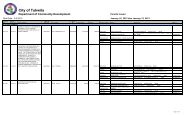
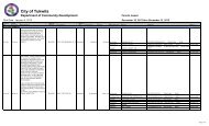
Shoreline Substantial Development Permit - the City of Tukwila
Shoreline Substantial Development Permit - the City of Tukwila
Shoreline Substantial Development Permit - the City of Tukwila

Create successful ePaper yourself
Turn your PDF publications into a flip-book with our unique Google optimized e-Paper software.
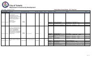
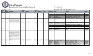
Check items<br />
submitted<br />
with<br />
application<br />
Information Required.<br />
May be waived in unusual cases, upon approval <strong>of</strong> both Public Works and Planning.<br />
5. Show any levee/riverbank maintenance easements.<br />
6. Construction limit lines and areas <strong>of</strong> clearing/grading/filling. See TMC 18.44.070 J for land<br />
altering regulations. Removal <strong>of</strong> any significant trees or native vegetation in <strong>the</strong> shoreline<br />
jurisdiction requires a <strong>Shoreline</strong> Tree Removal and Vegetation Clearing <strong>Permit</strong>.<br />
7. Show public access and/or trails per TMC 18.44.100.<br />
8. Show building footprint, parking lots, driveways, loading and service areas. See TMC 18.44.070 I<br />
for parking regulations.<br />
9. Identify any sensitive areas and <strong>the</strong>ir buffers, as applicable.<br />
D. CROSS-SECTIONS FOR SHORELINE PROJECTS<br />
E. LANDSCAPE PLAN:<br />
F. CIVIL PLANS:<br />
SHORELINE CROSS SECTIONS at maximum 75’ intervals along <strong>the</strong> shoreline showing:<br />
1. Existing and proposed elevations and improvements;<br />
2. Limits <strong>of</strong> <strong>the</strong> applicable shoreline buffer and 200 foot shoreline jurisdiction, as measured from <strong>the</strong><br />
OHWM;<br />
3. The top <strong>of</strong> bank elevation, landward catch point toe <strong>of</strong> levee, riverbank toe, ordinary high water<br />
mark and base flood elevation (i.e., <strong>the</strong> 100 year flood as determined by <strong>the</strong> Federal Emergency<br />
Management Administration - FEMA), and levee/ riverbank maintenance easement and <strong>the</strong><br />
location <strong>of</strong> <strong>the</strong> top <strong>of</strong> bank at a 2.5:1 slope.<br />
1. Landscape planting plan by a Washington State licensed landscape architect or an approved<br />
biologist. Plans must include <strong>the</strong> type, quantity, spacing and location <strong>of</strong> all plantings, soil<br />
preparation and amendment, irrigation, weed management, mulching and maintenance plan.<br />
Invasive vegetation must be removed and native vegetation planted. Maximum size 24” x 36”. See<br />
TMC 18.44.080 for requirements.<br />
2. Show all existing trees over 4” in caliper, indicating those to be retained, those to be removed and<br />
any tree protection measures required. Any trees removed over 4” in caliper are subject to <strong>the</strong><br />
replacement requirements <strong>of</strong> TMC 18.44.080 B.4.<br />
3. Provide notes on landscaping sheets that address consistency <strong>of</strong> landscaping with requirements<br />
<strong>of</strong> TMC 18.44.<br />
1. One set <strong>of</strong> all civil plans and analyses shall be stamped, signed and dated by a licensed<br />
pr<strong>of</strong>essional engineer. Include a graphic scale and north arrow. Maximum size 24” x 36”.<br />
2. Vertical datum NAVD 1988 and horizontal datum NAD 83/91. Conversion calculations to<br />
NGVD 1929, if in a flood zone or flood-prone area.<br />
See www.tukwilawa.gov/pubwks/bulletins/cablist.html , Bulletin A7 and related documents for fur<strong>the</strong>r<br />
information.<br />
3. Existing (dashed) and proposed (solid) topography at 2’ intervals.<br />
4. Construction limit lines, areas <strong>of</strong> clearing/grading/filling including volume and type <strong>of</strong> expected<br />
cut and fill.<br />
5. Existing and proposed utility easements and improvements.<br />
6. If additional impervious surface is proposed, provide a storm drainage design at least 90%<br />
complete, which meets <strong>the</strong> King County Surface Water Design Manual (KCSWDM). For guidance<br />
on preparation <strong>of</strong> <strong>the</strong> Technical Information Report contact <strong>the</strong> Public Works Dept. or go<br />
to: www.tukwilawa.gov/pubwks/pwpermit.html#SURFWATER.<br />
CPL Page 5 <strong>of</strong> 14 04/04/2014 10:00 AM<br />
W:\\Long Range Projects\<strong>Shoreline</strong>\New <strong>Shoreline</strong> <strong>Permit</strong>s\4-11-12 SSDP <strong>Permit</strong>