RIEGL - Geotec SpA
RIEGL - Geotec SpA
RIEGL - Geotec SpA

You also want an ePaper? Increase the reach of your titles
YUMPU automatically turns print PDFs into web optimized ePapers that Google loves.
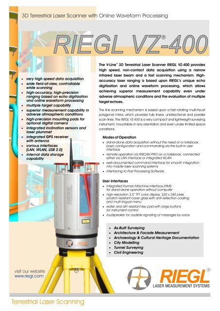
3D Terrestrial Laser Scanner with Online Waveform Processing<br />
visit our website<br />
www.riegl.com<br />
<strong>RIEGL</strong> VZ-400<br />
®<br />
�very high speed data acquisition<br />
�wide field-of-view, controllable<br />
while scanning<br />
�high-accuracy, high-precision<br />
ranging based on echo digitization<br />
and online waveform processing<br />
�multiple target capability<br />
�superior measurement capability in<br />
adverse atmospheric conditions<br />
�high-precision mounting pads for<br />
optional digital camera<br />
�integrated inclination sensors and<br />
laser plummet<br />
�integrated GPS receiver<br />
with antenna<br />
�various interfaces<br />
(LAN, WLAN, USB 2.0)<br />
�internal data storage<br />
capability<br />
Terrestrial Laser Scanning<br />
®<br />
The V-Line 3D Terrestrial Laser Scanner <strong>RIEGL</strong> VZ-400 provides<br />
high speed, non-contact data acquisition using a narrow<br />
infrared laser beam and a fast scanning mechanism. Highaccuracy<br />
laser ranging is based upon <strong>RIEGL</strong>’s unique echo<br />
digitization and online waveform processing, which allows<br />
achieving superior measurement capability even under<br />
adverse atmospheric conditions and the evaluation of multiple<br />
target echoes.<br />
The line scanning mechanism is based upon a fast rotating multi-facet<br />
polygonal mirror, which provides fully linear, unidirectional and parallel<br />
scan lines. The <strong>RIEGL</strong> VZ-400 is a very compact and lightweight surveying<br />
instrument, mountable in any orientation and even under limited space<br />
conditions.<br />
Modes of Operation<br />
�stand-alone data acquisition without the need of a notebook,<br />
basic configuration and commanding via the built-in user<br />
interface<br />
�remote operation via RiSCAN PRO on a notebook, connected<br />
either via LAN interface or integrated WLAN<br />
�well-documented command interface for smooth integration<br />
into mobile laser scanning systems<br />
�Interfacing to Post Processing Software<br />
User Interfaces<br />
�integrated Human-Machine Interface (HMI)<br />
for stand-alone operation without computer<br />
�high-resolution 3,5” TFT color display, 320 x 240 pixel,<br />
scratch resistant cover glass with anti-reflection coating<br />
and multi-lingual menu<br />
�water and dirt resistant key pad with large buttons<br />
for instrument control<br />
�loudspeaker for audible signaling of messages by voice<br />
�As-Built Surveying<br />
�Architecture<br />
& Facade Measurement<br />
�Archaeology<br />
& Cultural Heritage Documentation<br />
�City<br />
Modelling<br />
�Tunnel<br />
Surveying<br />
�Civil<br />
Engineering<br />
®<br />
LASER MEASUREMENT SYSTEMS
System Configuration<br />
Scanner Hardware <strong>RIEGL</strong> VZ-400<br />
allows high-speed, high resolution and accurate 3D measurements<br />
�Range up to 600 m @ Laser Class 1<br />
�Repeatability 3 mm<br />
�Measurement rate up to 122 000 measurements/sec<br />
�Field of View up to 100° x 360°<br />
�LAN/WLAN data interface, easily allowing wireless data<br />
transmission<br />
�Operated by any standard PC or Notebook or cable less<br />
�Fully portable, rugged & robust<br />
Software RiSCAN PRO<br />
<strong>RIEGL</strong> software package for scanner operation and data processing<br />
�Data archiving using a well-documented tree<br />
structure in XML file format<br />
�Object<br />
VIEW / INSPECTOR for intelligent<br />
data viewing and feature extraction<br />
�Straightforward<br />
Global Registration<br />
�Interfacing<br />
to Post Processing Software<br />
Digital Camera (optional)<br />
provides high resolution calibrated color images<br />
�NIKON D700, NIKON D300(s)<br />
- D700: 12.1 Megapixel, Nikon FX format<br />
- D300(s): 12.3 Megapixel<br />
- USB interface<br />
Mounting device with digital camera can be easily fixed by means of<br />
two knurled head screws. Precise position and orientation is provided by<br />
three supporting points. Power supply and USB 2.0 interface is provided<br />
by the scanner directly.<br />
The combination of the key components Scanner, Software and Camera results in<br />
�Automatic generation of high •Exact identification of details<br />
resolution textured meshes •Online position and distance measurements<br />
•Photorealistic 3D reconstruction •Online setting of any virtual point of view<br />
2<br />
Global Scan Position Registration<br />
Stand-alone Registration<br />
�integrated GPS receiver (L1)<br />
�integrated biaxial inclination sensors<br />
(tilt range ±10°, accuracy typ. ±0.008°)<br />
�RiSCAN PRO Processing and Multistation Adjustment Module (MSA)<br />
Registration via control points<br />
�precise and fast fine scanning of retro-reflectors<br />
�RiSCAN PRO Processing<br />
Totalstation-like-Registration<br />
�setup above well known point (integrated laser plummet)<br />
�integrated inclination sensors<br />
�precise fine scanning of well known remote target (reflector)<br />
�RiSCAN PRO Processing Backsighting function
308 mm<br />
Ø 180 mm<br />
Communication and Interfaces<br />
�LAN interface 10/100/1000 MBit/sec within<br />
rotating head<br />
�LAN interface 10/100 MBit/sec within base<br />
�integrated WLAN interface with rod antenna<br />
�USB 2.0 for external storage devices<br />
(USB flash drives, external HDD)<br />
�USB 2.0 for connecting the optional digital<br />
camera<br />
�connector for GPS antenna<br />
�two connectors for external power supply<br />
�connector for external GPS synchronization<br />
pulse (1PPS)<br />
�connector for optional GNSS receiver<br />
Scan Data Storage<br />
•internal 32 GByte flash memory<br />
(1 GByte reserved for the operating system)<br />
•external storage devices (USB flash drives or<br />
external hard drives) via USB 2.0 interface<br />
Add-on rechargeable battery<br />
Operating Elements and Connectors<br />
TOP VIEW<br />
�optional add-on rechargeable battery pack (high power, high capacity NiMH cells)<br />
�compact disc design, short-circuit-proof and protected connection pins<br />
�rechargeable during standard scan operation via external power supply<br />
�integrated micro-controller based charging electronics<br />
�easily pluggable to base of the laser scanner by central locking screw<br />
�DC voltage source (11-32 V DC) sufficient for recharging<br />
External power supply<br />
WLAN antenna<br />
Carrying handles<br />
�Intelligent power supply management, up to three independent external power<br />
sources can be connected simultaneously for uninterrupted operation<br />
�Reliable under- and over voltage protection<br />
�Wide external voltage supply range 11-32 V DC<br />
�Power consumption typ. 65 W<br />
�LED indicators for power status<br />
High-resolution color TFT display<br />
Key pad for instrument control<br />
Connectors for power supply and<br />
LAN interface 10/100 MBit/sec,<br />
power off/on button<br />
Mounting points (3x) and<br />
mounting threads inserts (2x)<br />
for digital camera<br />
Connector for GNSS receiver<br />
(optional)<br />
USB and DC power connector<br />
for digital camera<br />
Connector for GPS antenna<br />
Connector for WLAN antenna<br />
USB 2.0 slot for<br />
external memory devices<br />
LAN 10/100/1000 MBit/sec,<br />
for rapid download<br />
of scan data<br />
Power Supply<br />
3
®<br />
Technical Data 3D Scanner Hardware <strong>RIEGL</strong> VZ -400<br />
Laser Product Classification Class 1 Laser Product according to IEC60825-1:2007<br />
The following clause applies for instruments delivered into the United States:<br />
Complies with 21 CFR 1040.10 and 1040.11 except for deviations pursuant<br />
to Laser Notice No. 50, dated June 24, 2007.<br />
1)<br />
Range Performance<br />
Information contained herein is believed to be accurate and reliable. However, no responsibility<br />
is assumed by <strong>RIEGL</strong> for its use. Technical data are subject to change without notice.<br />
Long Range Mode High Speed Mode<br />
2)<br />
Laser PRR (Peak) 100 kHz 300 kHz<br />
2)<br />
Effective Measurement Rate 42 000 meas./sec 122 000 meas./sec<br />
3)<br />
Max. Measurement Range<br />
for natural targets ρ ≥ 90% 600 m 350 m<br />
for natural targets ρ ≥ 20% 280 m 160 m<br />
Max. Number of Targets per Pulse practically unlimited<br />
5) 7)<br />
Accuracy 5 mm<br />
6) 7)<br />
Precision 3 mm<br />
Minimum Range 1.5 m<br />
Laser Wavelength near infrared<br />
8)<br />
Beam Divergence 0.3 mrad<br />
<strong>RIEGL</strong> Laser Measurement Systems GmbH, A-3580 Horn, Austria<br />
Tel.: +43-2982-4211, Fax: +43-2982-4210, E-mail: office@riegl.co.at<br />
<strong>RIEGL</strong> USA Inc., Orlando, Florida 32819, USA<br />
Tel.: +1-407-248-9927, Fax: +1-407-248-2636, E-mail: info@rieglusa.com<br />
<strong>RIEGL</strong> Japan Ltd., Tokyo 1640013, Japan<br />
Tel.: +81-3-3382-7340, Fax: +81-3-3382-5843, E-mail: info@riegl-japan.co.jp<br />
4)<br />
CLASS 1<br />
LASER PRODUCT<br />
Physical Data temperature range 0°C to +40°C (operation), -10°C to +50°C (storage)<br />
protection class IP64 (dust and splash-proof)<br />
1) with online waveform processing 4) details on request<br />
2) rounded values 5) Accuracy is the degree of conformity of a measured quantity to its<br />
3) Typical values for average conditions. Maximum range is actual (true) value.<br />
specified for flat targets with size in excess of the laser 6) Precision, also called reproducibility or repeatability, is the degree to<br />
beam diameter, perpendicular angle of incidence, and for which further measurements show the same result.<br />
atmospheric visibility of 23 km. In bright sunlight, 7) One sigma @ 100 m range under <strong>RIEGL</strong> test conditions.<br />
the max. range is shorter than under an overcast sky. 8) 0.3 mrad correspond to 30 mm increase of beamwidth per 100 m of range.<br />
Scan Performance<br />
Vertical (Line) Scan Horizontal (Frame) Scan<br />
Scan Angle Range total 100° (+60° / -40°) max. 360°<br />
Scanning Mechanism rotating multi-facet mirror rotating head<br />
Scan Speed 3 lines/sec to 120 lines/sec<br />
10)<br />
0°/sec to 60°/sec<br />
Angular Stepwidth Δ ϑ (vertical), Δ ϕ (horizontal)<br />
9)<br />
0.0024° ≤ Δ ϑ ≤ 0.288°<br />
9)<br />
0.0024° ≤ Δ ϕ ≤ 0.5°<br />
between consecutive laser shots between consecutive scan lines<br />
Angle Measurement Resolution better 0.0005° (1.8 arcsec) better 0.0005° (1.8 arcsec)<br />
Inclination Sensors integrated, for vertical scanner setup position<br />
GPS receiver integrated, L1 antenna<br />
Compass optional, for vertical scanner setup position<br />
Internal Sync Timer integrated real-time synchronized time stamping of scan data<br />
Scan Sync (optional) scanner rotation synchronization<br />
9) selectable 10) frame scan can be disabled, providing 2D operation<br />
Max. Measurement Range<br />
The following conditions are assumed:<br />
Flat target larger than footprint of laser beam,<br />
perpendicular angle of incidence,<br />
average brightness<br />
®<br />
Maximum Measurement Range [m]<br />
650<br />
600<br />
550<br />
500<br />
450<br />
400<br />
350<br />
300<br />
250<br />
200<br />
150<br />
100<br />
weight approx. 9.6 kg<br />
50<br />
wet ice, black tar paper<br />
dry snow<br />
coniferous trees<br />
dry asphalt<br />
deciduous trees<br />
terra cotta<br />
construction concrete<br />
standard clear atmosphere: visibility 23 km<br />
clear atmosphere: visibility 15 km<br />
light haze: visibility 8 km<br />
medium haze: visibility 5 km<br />
Long Range Mode<br />
PRR = 100 kHz<br />
High Speed Mode<br />
PRR = 300 kHz<br />
0<br />
0 5 10 15 20 25 30 35 40 45 50 55 60 65 70 75 80<br />
Target Reflectivity [%]<br />
cliffs, sand, masonry<br />
white plaster work, limestone<br />
white marble<br />
www.riegl.com<br />
Data sheet, <strong>RIEGL</strong> VZ-400, 12/09/2011<br />
85<br />
90