Flood alleviation leaflet - Barnsley Council Online
Flood alleviation leaflet - Barnsley Council Online
Flood alleviation leaflet - Barnsley Council Online

Create successful ePaper yourself
Turn your PDF publications into a flip-book with our unique Google optimized e-Paper software.
<strong>Barnsley</strong> MBC– Highways and Engineering – Capital land drainage schemes<br />
No Location Solution No Location<br />
Solution<br />
1 Meadowgates, Bolton on Dearne<br />
Remove pipe. New headwall & trash screen 47 Storrs Mill Lane<br />
Regrade watercourse. Repair Highway Drain<br />
2<br />
3<br />
4<br />
5<br />
6<br />
7<br />
8<br />
9<br />
10<br />
11<br />
12<br />
Rear No.1 Foundry Street Elsecar<br />
High Street, Silkstone<br />
Spring Bank Close, Carlton<br />
Kendray Playing fields, off Hunningley Lane<br />
Thickett Lane Allotments, Worsbrough Dale Divert defective watercourse to new outfall<br />
Netherwood Nature Reserve, Low valley<br />
Broad Carr Road, Hoyland<br />
Old Broad Carr Road, Hoyland<br />
Stead Lane, Hoyland<br />
Low Laithes Lane, Aldham<br />
Scot Dyke, Royston rear Grange Road<br />
Clayton Lane, Thurnscoe<br />
Park Springs Nature Reserve, Low Valley<br />
Elsecar Heritage Centre Car Park<br />
Elsecar Heritage Railway<br />
Dearnlea Aged Persons Home, Thurnscoe<br />
Measborough Dyke, <strong>Barnsley</strong><br />
River Dove Maintenance Works, near<br />
Edmunds Road, Worsbrough<br />
Regrade ditch, repair culvert inlet<br />
Replace culvert headwall. New trash screen<br />
Regrade 200m overgrown & silted up ditch<br />
Replace culvert through playing fields<br />
Clean & regrade ditches. Improve overflow<br />
Clean out and regrade ditch<br />
Repairs to culvert. Clean out watercourse<br />
Clean out and regrade open watercourse<br />
Clean out and regrade open watercourse<br />
Regrade watercourse. Improve bridge<br />
13 Scot Dyke, Royston adjacent to Playing field Regrade 200m watercourse. Clean culvert<br />
14<br />
Regrade 150m of ditch. Improve outfall<br />
15 Mill House Bridge, Doncaster Road, Darfield Clean culverts. Regrade outfall ditch<br />
16<br />
17<br />
18<br />
19<br />
20<br />
21<br />
Form bund to watercourse. Protect dwellings<br />
Construct screen. Regrade 200m watercourse<br />
Clean out and regrade open watercourse<br />
Replace 75 metres of defective culvert<br />
Clean out debris from culvert headwall<br />
Clean out debris. Regrade river. Reinforce<br />
river bank. Replace Powder Mill Lane bridge.<br />
48<br />
49<br />
50<br />
51<br />
52<br />
53<br />
54<br />
55<br />
56<br />
57<br />
58<br />
59<br />
60<br />
61<br />
62<br />
63<br />
64<br />
65<br />
66<br />
Smithley Lane, Wombwell<br />
Silkstone Lane, Silkstone<br />
Old Anna Lane, Penistone<br />
Bird Lane/Hopping Lane, Thurgoland<br />
New Road, Elsecar<br />
Low Street, Gilroyd<br />
Water Royd Drive, Dodworth<br />
Hampole Drive, Thurnscoe<br />
Fitzwilliam Road, Elsecar<br />
Bank End Lane, High Hoyland<br />
Bradberry Balk Lane, Wombwell<br />
Chapel Lane, Carlton<br />
Engine Lane, Grimethorpe<br />
Pontefract Road, Broomhill<br />
Pontefract Road, Broomhill<br />
Higham Common Lane, Dodworth<br />
Green Road, Penistone<br />
Netherwood Road, Darfield<br />
Pog Well Lane, Higham<br />
Clean out and regrade open watercourses<br />
Clean out and regrade open watercourse<br />
Clean out and regrade open watercourse<br />
Reinforce embankment. Rebuild culvert.<br />
Regrade open watercourse<br />
Clean out and regrade open watercourse<br />
Repair damaged trash screen<br />
Clean out and regrade open watercourse<br />
Clean out and regrade open watercourse<br />
Regrade watercourse. Repair screen. Clean culvert<br />
Repair damaged retaining wall<br />
Clean out and regrade open watercourse<br />
Clean out open watercourse<br />
Reinforcement to damaged bank<br />
Trash screen removal<br />
Emergency flood <strong>alleviation</strong> works<br />
Clean watercourse. Improve Highway drainage<br />
Construct new culvert entrance<br />
67 Cawthorne Dike maintenance works, Darton Clean out debris<br />
Regrade watercourse. Improve Highway drainage<br />
Regrade watercourse. Rebuild culvert & footpath<br />
<strong>Barnsley</strong> MBC -<br />
<strong>Flood</strong> Alleviation Works<br />
From 2007 - 2010<br />
22<br />
River Dove adjacent to Swaithe Viaduct<br />
Clean out debris<br />
68<br />
Valley Road Industrial Estate, Wombwell<br />
Remove collapsed parapet wall<br />
23<br />
River Dove between Wombwell Lane and<br />
Swaithe Viaduct<br />
Clean out trees collapsed into river channel<br />
69<br />
Bulling Dike maintenance works, Station<br />
Road to Gypsy Encampment<br />
Clean out debris. Regrade watercourse.<br />
Reinforcement to collapsed river bank<br />
24<br />
River Dove, Trans Pennine Trail, Aldham<br />
Clean out debris<br />
70<br />
Worsbrough Reservoir<br />
Installation of telemetry on River Dove<br />
25<br />
River Dove, Lewden Bridge, Station Road,<br />
Worsbrough<br />
Repairs to parapet wall of bridge<br />
71<br />
Bridge End, Penistone<br />
Clean out debris. Regrade river. Reinforce<br />
river bank. Remove silt from River Don<br />
26<br />
27<br />
River Dove between Wombwell Lane and<br />
Netherwood Road<br />
River Dove between Netherwood Road and<br />
Pit Bridge<br />
Clean debris. Regrade river. Reinforce river<br />
bank. Repair bridge. Remove silt from river<br />
Clean debris. Regrade river. Remove collapsed<br />
bridge. Reinstate damaged footpath<br />
72<br />
73<br />
Outstanding works to be completed 2011/2012<br />
George Street, Thurnscoe<br />
Repair drain. Protect from flooding<br />
Lilydene Avenue, Grimethorpe<br />
Construct new culvert entrance<br />
28<br />
29<br />
30<br />
31<br />
32<br />
33<br />
34<br />
35<br />
36<br />
37<br />
38<br />
39<br />
40<br />
41<br />
42<br />
43<br />
44<br />
45<br />
46<br />
River Dove between Pit Bridge and<br />
Stoneyford Road<br />
Watercourse at rear of Alba Close, Darfield<br />
Cannon Hall Park, Cawthorne<br />
Trans Pennine Trail, various locations<br />
River Dearne, Lundwood<br />
Brierley Road, Grimethorpe<br />
Lund Hill Lane, Lundhill<br />
Cinder Hill Farm, Cawthorne<br />
Locke park, <strong>Barnsley</strong><br />
River Dearne Bridges<br />
(Lundwood; Darton; Darfield; <strong>Barnsley</strong>)<br />
Wombwell Lane, Aldham Bridge<br />
Round Green Lane, Rockley<br />
Gudgeon Hole Lane, Crane Moor<br />
Dance Lane, Crane Moor<br />
Coalfields Link Road, Middlecliffe<br />
Mortimer Road, Cubley<br />
A629 Booth Wood Lodge<br />
Pinfold Hill, Silkstone Common<br />
Park Lane, Roughbirchworth<br />
Clean debris and regrade river and construct<br />
reinforcement to collapsed river bank<br />
Clean out debris. Regrade 300m watercourse<br />
Construct new overflow pipe<br />
Regrade drainage ditches and culverts<br />
Remove collapsed bridge for right of way<br />
Rebuild collapsed culverts<br />
Improvement to culvert inlet<br />
Repair culvert. Reinforce bank side<br />
Construct cut off drain. Remove risk of flood<br />
Clear debris from underside of road bridges<br />
Highway drainage improvements<br />
Rebuild collapsed culvert<br />
Rebuild culvert. Replace screen. Repair carriageway<br />
Rebuild embankment due to land slip<br />
Rebuild embankment due to land slip<br />
Rebuild embankment due to land slip<br />
Rebuild embankment. Rebuild culvert<br />
Clean out and regrade open watercourse<br />
Regrade watercourse. Replace headwall<br />
74<br />
75<br />
76<br />
77<br />
78<br />
79<br />
80<br />
81<br />
82<br />
83<br />
84<br />
85<br />
86<br />
87<br />
88<br />
89<br />
90<br />
91<br />
Wombwell Bypass, former canal ditch<br />
Elsecar Heritage Centre<br />
Canal Street, <strong>Barnsley</strong><br />
Carlton Marsh Nature Reserve<br />
Oaks Farm Drive, Darton<br />
Cemetery Road, Hemingfield<br />
Cudworth Dyke, Carlton Marsh<br />
Fountain Square, Darton<br />
Lister Row, Great Houghton<br />
Ings Road, Darfield<br />
Pitt Street, Darfield<br />
Church Street, Darton<br />
Darton Village<br />
Lower Barugh<br />
Burton Grange (Lundwood)<br />
Low Valley<br />
Darfield Bridge<br />
Bolton on Dearne<br />
<strong>Flood</strong> store sites<br />
Clean out open watercourse<br />
CCTV inspection to culvert under Centre<br />
Clean out debris. Regrade watercourse,<br />
Reinforce bank. Replace trash screen<br />
Construct new screen. Reinforce downstream<br />
of Boulder Bridge Recycling area<br />
Highway drainage improvement works<br />
Reinforcement to bank. Regrade watercourse<br />
Reinforcement to bank<br />
Repair damaged retaining wall<br />
Land drainage improvement works<br />
Replace damaged culvert<br />
Construct new culvert entrance<br />
Regrade river. Repair drainage. Replace culvert<br />
Post Office car park<br />
Dearne Hall Road lay by<br />
Community Centre car park<br />
Old <strong>Council</strong> Depot car park<br />
Attlee Crescent<br />
Awaiting Planning consent<br />
The unprecedented rainfall June 2007 caused significant<br />
amounts of flood damage across the whole of the<br />
borough and resulted in properties being inundated in 48<br />
separate locations. All three of <strong>Barnsley</strong>’s main rivers –<br />
Dearne, Don and the Dove were affected in that they were<br />
unable to contain the flood waters.<br />
The effects of the flooding were not limited to households,<br />
as <strong>Barnsley</strong> MBC suffered severe damage to key<br />
infrastructure such as roads, bridges and culverted<br />
watercourses which feed these main rivers. These<br />
watercourses became choked with debris washed down<br />
from upstream areas, and in many cases this led to<br />
flooding of highways and homes. In other cases the<br />
volume of water caused these watercourses to become<br />
overwhelmed leading to flooding.<br />
BARNSLEY<br />
Metropolitan Borough <strong>Council</strong><br />
Since June 2007 <strong>Barnsley</strong> <strong>Council</strong> has carried out a wide<br />
range of activities to repair, replace and improve assets<br />
which were damaged as a result of the floods. Its staff has<br />
worked hard to locate areas which pose a risk of flooding<br />
and have developed innovative solutions to reduce the risk<br />
of a reoccurrence of the events of June 2007.<br />
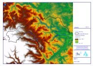
The map overleaf highlights the areas where remedial<br />
action has been taken to by both <strong>Barnsley</strong> <strong>Council</strong> alone,<br />
and in conjunction with its partners to alleviate the<br />
problems which caused flooding in 2007.<br />
<strong>Barnsley</strong> <strong>Council</strong> will continue to seek out and deal with<br />
problems in watercourses and highways drainage systems<br />
that pose a risk of flooding to residents of the borough.<br />
You can help this process by reporting flood related issues<br />
to the dedicated<br />
HOTLINE – 01226 773555
KEY<br />
BMBC<br />
EA<br />
BMBC / EA<br />
BMBC / IDB<br />
58 - Bradberry Balk Lane,<br />
Wombwell - after flood<br />
damage (road closed)<br />
21 - Powder Mill Lane river bank, Worsbrough<br />
- after flood damage<br />
Jct.<br />
<strong>Barnsley</strong><br />
Metropolitan Borough<br />
Motorway<br />
Major roads<br />
Sta.<br />
B roads<br />
Railways<br />
Rivers<br />
Major watercourses<br />
C Crown copyright.<br />
<strong>Barnsley</strong> Metropolitan Borough <strong>Council</strong>,<br />
Licence No. LA10002264.<br />
To Manchester<br />
A628<br />
Winscar<br />
Res<br />
Dunford<br />
Bridge<br />
43 - Mortimer Road, Cubley - after flood repairs<br />
58 - Bradberry Balk Lane, Wombwell - after flood repairs<br />
A629<br />
Ingbirchworth Res<br />
A616<br />
River<br />
Don<br />
Ingbirchworth<br />
Crow<br />
Edge<br />
Millhouse<br />
Green<br />
Langsett<br />
Scout Dike Res<br />
Thurlstone<br />
A635<br />
Penistone<br />
43<br />
50<br />
Langsett Res<br />
Hoylandswaine<br />
71<br />
Cubley<br />
64<br />
Cawthorne<br />
Oxspring<br />
46<br />
57<br />
Underbank Res<br />
High<br />
Hoyland<br />
30<br />
A637<br />
Kexbrough<br />
Silkstone<br />
Thurgoland<br />
River<br />
Don<br />
35<br />
51<br />
3<br />
49<br />
Green<br />
Moor<br />
43 - Mortimer Road,<br />
Cubley - after flood<br />
damage (road closed)<br />
J38<br />
Silkstone<br />
Common<br />
45<br />
To Leeds<br />
& M62<br />
67<br />
Barugh<br />
Staincross<br />
Darton<br />
Higham<br />
Dodworth<br />
Crane<br />
40<br />
Moor<br />
41<br />
85 81 78<br />
86<br />
37 85<br />
66<br />
Wortley<br />
Athersley<br />
River<br />
Dearne<br />
BARNSLEY<br />
Hood<br />
Green<br />
Howbrook<br />
44<br />
63<br />
31<br />
87<br />
A629<br />
54<br />
53<br />
31<br />
J37<br />
31<br />
A61<br />
Pilley<br />
Tankersley<br />
A616<br />
Worsbrough<br />
Res<br />
M1<br />
31 31<br />
39<br />
36<br />
76 37<br />
70 21<br />
Birdwell<br />
Royston<br />
12<br />
13<br />
Kendray<br />
Worsbrough<br />
Village<br />
J36<br />
A61<br />
To Sheffield<br />
20<br />
Carlton<br />
59<br />
6<br />
4<br />
5<br />
Shafton<br />
Lundwood<br />
37<br />
88<br />
77<br />
80<br />
Ardsley<br />
River<br />
Dove<br />
Wombwell<br />
23 25<br />
Hoyland<br />
10 8<br />
9<br />
22<br />
A6135<br />
To Sheffield<br />
Rotherham<br />
& South<br />
Jump Hemingfield<br />
Elsecar<br />
Cudworth<br />
48<br />
2<br />
56<br />
75<br />
17<br />
32<br />
Grimethorpe<br />
60<br />
Darfield<br />
Elsecar Res<br />
Brierley<br />
73<br />
33<br />
River<br />
Dearne 47<br />
Little42<br />
Houghton<br />
Middlecliffe<br />
11 29<br />
15<br />
24 26<br />
37<br />
90<br />
38 7<br />
58 65<br />
84<br />
27 68<br />
28 89 69<br />
16 83<br />
Broomhill 61<br />
74<br />
62<br />
79<br />
18<br />
52<br />
34<br />
A628<br />
82<br />
A6195<br />
Great<br />
Houghton<br />
Thurnscoe<br />
Billingley<br />
14<br />
19<br />
55<br />
Goldthorpe<br />
River<br />
DearneBolton upon<br />
Dearne<br />
A633<br />
91<br />
1<br />
21 - Powder Mill Lane river<br />
bank, Worsbrough<br />
- after flood repairs<br />
72<br />
A635<br />
Scale<br />
0 1 2 3 4 miles<br />
17 - Elsecar Heritage Centre<br />
- after flood damage<br />
17 - Elsecar Heritage Centre - after flood repairs