

2006 Annual Report - NASA Airborne Science Program
2006 Annual Report - NASA Airborne Science Program
2006 Annual Report - NASA Airborne Science Program

You also want an ePaper? Increase the reach of your titles
YUMPU automatically turns print PDFs into web optimized ePapers that Google loves.
809<br />
National Aeronautics and Space Administration<br />
<strong>NASA</strong> <strong>Science</strong> Mission Directorate<br />
Suborbital <strong>Science</strong> <strong>Program</strong><br />
<strong>2006</strong> <strong>Annual</strong> <strong>Report</strong>
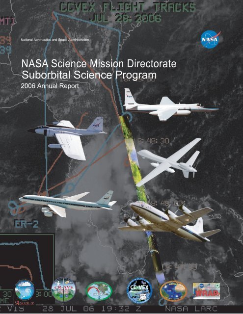
On the cover:<br />
The five principle <strong>NASA</strong> catalog platforms, from the top: the ER-2 (DFRC), the WB-57F (JSC),<br />
the Ikhana Predator-B UAS (DFRC), the DC-8 (University of North Dakota Co-op), and the P-3<br />
(WFF). The background image, from the <strong>2006</strong> CC-VEx experiment, includes plots of flight tracks<br />
and altitude profiles from the ER-2 and the WM, Inc. Learjet 35A, overlain on a GOES-12 satellite<br />
visible image. Part of the ER-2 flight track includes a segment of the multi-spectral infrared<br />
imagery acquired by the MAS instrument during this July 28, <strong>2006</strong> mission. Arrayed across the<br />
bottom are logos from the six major airborne science campaigns supported by the Suborbital<br />
<strong>Program</strong> in FY06.
<strong>NASA</strong> <strong>Science</strong> Mission Directorate<br />
Earth <strong>Science</strong> Division<br />
Suborbital <strong>Science</strong> <strong>Program</strong><br />
<strong>Annual</strong> <strong>Report</strong> <strong>2006</strong><br />
MARCH 2007<br />
http://suborbital.nasa.gov
TABLE OF CONTENTS<br />
Executive Summary ................................................................................................ 1<br />
Introduction ................................................................................................................ 7<br />
<strong>Program</strong> Elements<br />
<strong>Science</strong> Requirements and Management ................................................................ 13<br />
Platform Catalog ...................................................................................................... 15<br />
New Technologies ................................................................................................... 16<br />
<strong>Science</strong> Instrumentation and Support Systems ....................................................... 18<br />
Aircraft Missions and Accomplishments<br />
CR-AVE .................................................................................................................... 25<br />
Stardust Re-Entry .................................................................................................... 28<br />
Arctic Sea Ice ........................................................................................................... 30<br />
INTEX-B/MILAGRO .................................................................................................. 34<br />
CC-VEx .................................................................................................................... 40<br />
Manta Maldives AUAV Campaign ............................................................................ 42<br />
NAMMA ................................................................................................................... 44<br />
Western States Fire Mission <strong>2006</strong> Campaign .......................................................... 46<br />
Esperanza Fire Support Mission .............................................................................. 49<br />
Technology Development<br />
UAVSAR .................................................................................................................... 53<br />
Ikhana ....................................................................................................................... 56<br />
Altair ......................................................................................................................... 58<br />
SIERRA ..................................................................................................................... 60<br />
Over-the-Horizon Suborbital Telepresence .............................................................. 61<br />
REVEAL .................................................................................................................... 64<br />
iii
Catalog Aircraft<br />
DC-8 ................................................................................................................... 69<br />
WB-57 ................................................................................................................. 71<br />
ER-2 ..................................................................................................................... 73<br />
P-3 ....................................................................................................................... 75<br />
Twin Otter ............................................................................................................. 76<br />
Jetstream 31 ....................................................................................................... 77<br />
Cessna Caravan ................................................................................................... 78<br />
B-200 .................................................................................................................. 79<br />
Aerosonde ........................................................................................................... 81<br />
Flight Requests ........................................................................................................ 85<br />
Collaborations and Partnerships ........................................................................ 89<br />
Community Outreach ............................................................................................. 91<br />
Looking Ahead to FY07 and Beyond ............................................................... 97<br />
APPENDIX A: Platform Characteristics ...................................................................... 101<br />
APPENDIX B: Acronyms .............................................................................................. 103<br />
iv
LIST OF FIGURES<br />
FIG. No. CAPTION PAGE No.<br />
1 AMS sensor components installed on pod, later flown on the<br />
Altair.<br />
2 UAS Telemetry Link Module. 18<br />
3 CAR instrument installation in the nose of the J-31 aircraft. 19<br />
4 Cirrus DCS image of La Paguera, Puerto Rico. 20<br />
5 MASTER data, acquired Sept. 25, <strong>2006</strong>, over Yellowstone<br />
National Park.<br />
6 WB-57 CR-AVE flight tracks. 25<br />
7 CR-AVE remote sensing instrument payload. 26<br />
8 CR-AVE in-situ instrument payload. 26<br />
9 WB-57 pilot preparing for flight. 27<br />
10 WB-57 at Santa Maria Airport, San Jose, Costa Rica. 27<br />
11 Image of Stardust capsule re-entry. 28<br />
12 Stardust Observation Campaign Team. 29<br />
13 Arctic <strong>2006</strong> Transit Pattern. 30<br />
14 Phase 1 flights from Fairbanks. 31<br />
15 Arctic Sea Ice <strong>Science</strong> Team. 31<br />
16 Thule, Greenland ramp flight path. 32<br />
17 Phase 3, Traverse 1. 33<br />
18 Phase 3, Traverse 2. 33<br />
19 INTEX-B <strong>Science</strong> Team deployed to Anchorage, AK. 34<br />
20 DC-8 intercomparison flight with NCAR C-130. 35<br />
21 Summary of DC-8 flight tracks. 35<br />
22 Kulis Air National Guard base in Anchorage, AK. 36<br />
23 Comparison of Aura and DIAL ozone profiles. 36<br />
24 Sky Research J-31 aircraft on the ramp at General Heriberto<br />
Jara International Airport, Veracruz, Mexico.<br />
25 J-31 <strong>Science</strong> Team flight planning meeting. 37<br />
26 J-31 flight over Mexico City. 37<br />
27 Three-dimensional rendering of aerosol backscatter profiles<br />
from the 13 March MILAGRO flight.<br />
28 Comparison of OMI and AATS aerosol optical depth 39<br />
29 CloudSat/CALIPSO pairing. 40<br />
18<br />
21<br />
37<br />
38<br />
v
FIG. No. CAPTION PAGE No.<br />
30 Meteorological forecast of Northern hemisphere. 41<br />
31 Satellite tracks of cloud formation. 41<br />
32 Asphalt road serves as makeshift runway. 42<br />
33 Hanimaadhoo Island. 42<br />
34 AUAV on short final approach. 43<br />
35 Primary and back-up aircraft in hangar. 43<br />
36 <strong>NASA</strong> DC-8 aircraft on the ramp at Amilcar Cabral Airport. 44<br />
37 NAMMA <strong>Science</strong> Team receives weather briefing. 44<br />
38 Dr. Jim Podolske examines laser absorption spectrometer data. 45<br />
39 Dr. Ed Browell on-board DC-8 with Cape Verdean students. 45<br />
40 Altair in flight with AMS-Wildfire sensor on-board. 46<br />
41 Real-time screen capture of Altair entering the NAS. 47<br />
42 Three thermal images collected from AMS scanner. 48<br />
43 Calibration/Validation of MODIS Fire Detects with AMS Wiildfire<br />
Sensor.<br />
44 AMS Wildfire Sensor data collected over Esperanza Fire. 49<br />
45 UAVSAR pod in loading fixture. 53<br />
46 UAVSAR pod mounted to GIII. 53<br />
47 PPA hardware in equipment rack. 54<br />
48 GIII aircraft interior. 54<br />
49 Monte Carlo simulation. 55<br />
50 Ikhana on runway. 56<br />
51 Ikhana UAS mobile ground control station. 57<br />
52 General Atomics’ Altair in flight. 58<br />
53 Sensor pod with payload installed. 58<br />
54 SIERRA UAS 60<br />
55 Screen shot of REVEAL provided DC-8 ground track data<br />
through Iridium communications satellites.<br />
56 DC-8 ground track data overlaid on weather satellite imagery. 63<br />
57 REVEAL box. 65<br />
58 Serial data stream on computer monitor. 65<br />
59 DC-8 69<br />
60 WB-57s over Houston, TX. 71<br />
61 Image of PNH launch taken with WAVE sensor on board WB-57. 72<br />
62 WB-57 in service bay. 72<br />
63 ER-2 73<br />
48<br />
62<br />
vi
FIG. No. CAPTION PAGE No.<br />
64 P-3 75<br />
65 Twin Otter 76<br />
66 Jetstream-31 77<br />
67 Cessna Caravan 78<br />
68 B-200 79<br />
69 Daytime MODIS/ASTER color infrared composite image of<br />
Garlock Fault.<br />
70 Night thermal infrared image of Garlock Fault. 80<br />
71 Aerosonde launched from catapult mounted onto truck roof. 81<br />
72 NSERC Director Rick Shetter interviewed during INTEX-B<br />
campaign<br />
73 CR-AVE press conference in Costa Rica, January <strong>2006</strong> 92<br />
80<br />
91<br />
LIST OF TABLES<br />
1 FY06 Flight Request Summary 85<br />
vii
Executive Summary<br />
Earth <strong>Science</strong> at <strong>NASA</strong> is a science driven program focused on<br />
better understanding the Earth system through global, spacebased<br />
observations. The Suborbital <strong>Science</strong> <strong>Program</strong> plays a key<br />
complementary role by providing to the science community unique<br />
airborne platforms. What sets the <strong>NASA</strong> suborbital program apart<br />
from other airborne programs are the unique platforms that have been<br />
highly modified to make the necessary observations, the breadth of<br />
measurement capabilities spanning the full range of science focus<br />
areas and the link made between the suborbital and space-based<br />
observations. The program fulfills three primary roles, providing: in<br />
situ and remote sensing observations of Earth system processes not<br />
attainable via space based observation, calibration and validation<br />
measurements that allow better understanding of the space based<br />
remote sensing observations and a development path for instrument<br />
concepts whose final destination is space.<br />
was a very busy year for the Suborbital <strong>Science</strong><br />
<strong>2006</strong> <strong>Program</strong>. There were seven major field campaigns<br />
supporting a wide range of Earth science disciplines from atmospheric<br />
composition, hurricane genesis, cryosphere, aerosols and clouds, and<br />
disaster response; all linked in various ways to climate change. <strong>NASA</strong><br />
campaigns covered a wide range of global locations, from the tropical<br />
tropopause region in Costa Rica to the frozen ice sheets of Greenland,<br />
Alaska and Canada. In addition to the Earth science studies, the first<br />
mission conducted on the DC-8, four months after its move to the<br />
University of North Dakota, was the Stardust mission, which made a<br />
range of visual and spectral observations of the entry of the Stardust<br />
Sample Return Capsule. The capsule entered the atmosphere at a<br />
higher rate of speed than any previous man-made object in history.<br />
1
The Stardust mission provided key information on thermal protection<br />
system performance, important to <strong>NASA</strong>’s Vision for Space Exploration.<br />
While the DC-8 was flying the Stardust mission, the WB-57 was at KSC<br />
supporting the Pluto New Horizon launch, the fastest moving satellite<br />
man has yet launched. The WB-57 using the WAVE camera developed<br />
for shuttle launches monitored the PNH satellite downrange at 60,000<br />
feet and tracked it from launch to orbit insuring that had an anomaly<br />
occurred, the satellite could be imaged all the way to the ocean.<br />
The Costa Rica Aura Validation Experiment (CR-AVE) was conducted<br />
in January <strong>2006</strong>. With a payload of 29 instruments on the WB-57<br />
aircraft, the mission returned measurements from the tropical upper<br />
troposphere/lower stratosphere, an important region of the atmosphere<br />
for understanding ozone recovery and impacts of climate change. Also<br />
important were key satellite validation measurements often obtained<br />
by coordinating the aircraft flight tracks with satellite overpasses,<br />
particularly the EOS Aura satellite.<br />
Also providing key satellite validation measurements was the CALIPSO-<br />
CloudSat Validation Experiment (CC-VEx). This experiment was<br />
conducted with the ER-2 and B-200 aircraft based out of Warner<br />
Robbins, Georgia, and <strong>NASA</strong> Langley, respectively. CALIPSO and<br />
CloudSat were on the most recent Earth science satellite launch and<br />
are providing important new three-dimensional views of convective<br />
cloud systems. CC-VEX provided critical measurements to validate<br />
those from space.<br />
The Arctic Sea Ice Mission was conducted in three phases in March<br />
<strong>2006</strong> over Alaska, northern Canada, and Greenland. This campaign,<br />
using both new and proven instruments on the P-3 aircraft, provided<br />
important measurements for validation of the AMSR-E instrument on<br />
the Aqua EOS spacecraft and the GLAS instrument on ICESat. The<br />
mission also returned important new survey data of the Greenland<br />
ice sheet, one of the most important regions of the planet for<br />
understanding the impact of global warming<br />
The largest, most complex mission flown in <strong>2006</strong> was the <strong>NASA</strong><br />
INTEX-B mission conducted in coordination with the NSF MILAGRO<br />
mission. This campaign to understand intercontinental transport and<br />
2
transformation of natural and human generated pollution across the<br />
Pacific included over 300 scientists, engineers and technical staff in<br />
the field in Mexico, Texas, Hawaii, Alaska and Washington State. In<br />
addition to the U.S., there was significant participation by Mexico,<br />
Canada and Germany. Aircraft involved included the <strong>NASA</strong> DC-8 and<br />
B-200, the NCAR C-130 and the Sky Research Jetstream J-31.<br />
The <strong>NASA</strong> African Monsoon Multidisciplinary Activities (NAMMA)<br />
mission was conducted from Cape Verde off of the western Africa<br />
coast in August and September <strong>2006</strong>. This major mission was the<br />
first ever study focused on obtaining comprehensive measurements to<br />
better understand the genesis of Atlantic hurricanes, which are formed<br />
by the instability and intensification of the African Easterly Waves<br />
coming off the continent. In addition to coordination with satellite data,<br />
<strong>NASA</strong>’s TOGA and NPOL research radars, and the SMART-COMMIT<br />
mobile research ground station, were deployed to Cape Verde and<br />
Senegal. Seven easterly waves were studied along with a number of<br />
samples of the Saharan Air Layer carrying significant dust loading from<br />
the Sahara desert.<br />
In FY06, <strong>NASA</strong> continued to demonstrate the use of unmanned aircraft<br />
to complement the existing aircraft suite. The <strong>NASA</strong> Suborbital<br />
<strong>Science</strong> <strong>Program</strong> assisted the Scripps Institute of Oceanography (UC<br />
San Diego) in conducting the first of its kind, multi-UAS mission to<br />
the Maldives in the Indian Ocean. Three Manta UAS were flown in<br />
a stack formation making simultaneous aerosol and solar radiation<br />
measurements in a vertical profile using advanced autonomous<br />
avionics to coordinate the aircraft flight tracks in this NSF led<br />
experiment.<br />
A second UAS mission was the first significant long duration UAS<br />
science flight in the National Airspace over the continental U.S. The<br />
<strong>Program</strong> supported the Wildfire Research and Applications <strong>Program</strong><br />
(WRAP) funded by the Applied <strong>Science</strong>s Division, in working with the<br />
U.S. Forest Service to demonstrate the use of unmanned systems for<br />
disaster mitigation. The most significant accomplishment of the WRAP<br />
project was in response to an emergency request from the California<br />
Governor’s Office of Emergency Services, for <strong>NASA</strong> to provide<br />
assistance to the California Department of Forestry (CDF) as they were<br />
battling a fatal southern California wildfire (known as the Esperanza<br />
3
Fire). Using the Altair UAS with a newly developed IR sensor, on board<br />
processing, and an end-to-end communication and information delivery system,<br />
<strong>NASA</strong> provided the California Department of Forestry (CDF) critical information<br />
on the spreading fire that was used to direct the “boots on the ground” to get the<br />
fire contained.<br />
The recently published National Research Council Decadal Survey for Earth<br />
<strong>Science</strong> has endorsed and stressed the importance of <strong>NASA</strong>’s Suborbital<br />
<strong>Science</strong> <strong>Program</strong>. The following is an excerpt from the Decadal Survey:<br />
COMPLEMENTING OBSERVATIONS FROM SPACE<br />
Space-based observations provide a global view of many Earth<br />
system processes; however, satellite observations have a number<br />
of limitations, including spatial and temporal resolution and the<br />
inability to observe certain parts of the Earth. Hence, they do<br />
not provide a picture of the Earth system that is sufficient for<br />
understanding key physical, chemical, and biological processes.<br />
Observations from surface-based (land and ocean) and aerial in<br />
situ sensors complement satellite observations through calibration<br />
and validation campaigns, and by making critical measurements<br />
in places and with accuracy, precision, and resolution that are<br />
not obtainable from space. In addition, satellites do not directly<br />
observe many of the changes in human societies that are affected<br />
by or affect the environment. The requisite Earth information<br />
system therefore requires... surface-based and suborbital airborne<br />
observations...to complement the observations from space.<br />
In recent years the program has gone through a number of changes, including<br />
multiple moves and reduced funding for some of the conventional aircraft,<br />
and an initial optimism in the promise of UAS technologies, that has proven to<br />
4
e slower in developing and more expensive than anticipated. The<br />
NRC report issued the following recommendation with regard to this<br />
situation:<br />
Recommendation:<br />
<strong>NASA</strong> should support Earth science research via suborbital<br />
platforms: airborne programs, which have suffered<br />
substantial diminution, should be restored,<br />
and UAV technology should<br />
be increasingly factored into<br />
the nation’s<br />
strategic plan for<br />
Earth sciences<br />
For FY 2007 and beyond, the <strong>Program</strong> will have a strategic, customer<br />
focused plan for investments in aircraft, science support system<br />
enhancements, and new technologies. Challenging missions, such as<br />
the multi-aircraft Tropical Composition, Clouds and Climate Coupling<br />
campaign in Costa Rica, are planned, as well as potential missions<br />
UAS compatible sensors selected from the Research Opportunities in<br />
Space and Earth <strong>Science</strong>s International Polar Year solicitation. New<br />
technology demonstrations are scheduled for the planned Ikhana<br />
unmanned aircraft system as well as collaborative efforts, such as the<br />
Aerosonde hurricane boundary level experiment with NOAA.<br />
Although <strong>2006</strong> saw a number of important and highly visible successes<br />
accomplished by the Suborbital <strong>Science</strong> <strong>Program</strong>, there is also a need<br />
to continually evaluate the program and re-assess the priorities of the<br />
program based on science driven requirements.<br />
5
Introduction<br />
Understanding Earth System processes, how they change, and the potential<br />
effect of human activity to that change, continues to be of intense interest<br />
to both the general public and the scientific community. In particular, <strong>2006</strong> was<br />
a year in which global climate change received increased domestic and international<br />
attention, and we witnessed a range of social, media, governmental, and<br />
scientific reactions to what we may be facing in the years to come.<br />
<strong>NASA</strong>’s important role in understanding the Earth System continues through<br />
the collection and analysis of data on ozone, carbon dioxide, fires, dust and<br />
aerosols, point source pollution, precipitation and storms, including hurricanes,<br />
atmospheric trace gases, polar ice, land changes, and so on. While much of<br />
this data come from satellites, the data obtained from aircraft, balloons, rockets,<br />
and ground stations play an essential role in understanding the geophysical<br />
processes and interpreting the satellite information.<br />
The Suborbital <strong>Science</strong> <strong>Program</strong> (SSP) at <strong>NASA</strong> is continuing to play a pivotal<br />
role in its support to the nation’s science endeavors, and this past year has been<br />
a successful one. The program supported multiple earth and space science<br />
missions, demonstrated new technologies for science data acquisition, and<br />
implemented new management structures to more effectively use its airborne<br />
platforms. <strong>NASA</strong> also completed the first year of a five-year cooperative agreement<br />
with the University of North Dakota to operate its DC-8 flying laboratory.<br />
The program continues to develop the framework to align assets and investments<br />
with the Earth <strong>Science</strong> Research and Analysis <strong>Program</strong> strategic science<br />
roadmap.<br />
The suborbital program continues to operate by its four principal goals:<br />
• Support focused science missions that are formulated to implement<br />
and follow <strong>NASA</strong> science roadmaps through competitively selected<br />
projects.<br />
7
• Maintain and evolve an adaptive and responsive suite of platforms<br />
selected according to the observational needs and requirements of the<br />
science focus areas.<br />
• Infuse new airborne technologies based on advances and developments<br />
in aeronautics, information technologies, and sensor systems.<br />
• Transfer proven capabilities to research, operational, or commercial operators<br />
as widely available facilities for community-driven experiments<br />
or operational decision support systems.<br />
The program is not without challenges, including significant budget limitations<br />
and a longer-than-anticipated timeline for UAS technology insertion, but the<br />
support to the science community remains strong, in no small part due to the<br />
support and dedication of the personnel and organizations across the <strong>NASA</strong><br />
field centers and their partners that comprise the suborbital team.<br />
The increasing importance of the global climate change issue, the effect of more<br />
rapidly changing climate parameters, and the requirement for in situ validation,<br />
underscores the need for continued suborbital measurements. Our program<br />
couples continued operation of airborne science platforms with the evolution of<br />
new technologies, and the collection and evaluation of earth science requirements<br />
to forecast future use of its assets. The importance of the suborbital program<br />
to the agency’s mission was also recently endorsed by the Earth <strong>Science</strong><br />
Subcommittee of the <strong>NASA</strong> Advisory Committee (NAC).<br />
In this report, you will find a summary of the significant accomplishments that<br />
were achieved in the Suborbital <strong>Science</strong> <strong>Program</strong> in fiscal year <strong>2006</strong>, and a<br />
discussion of where the program is headed over the next several years. The<br />
report details program activities in field campaign mission support, technology<br />
development, requirements and aircraft catalog management, sensors, airborne<br />
science flight requests, and external partnerships.<br />
8
<strong>Program</strong> Elements
The Suborbital <strong>Science</strong> <strong>Program</strong> (SSP) consists of four program<br />
elements which are described in the following sections:<br />
• <strong>Science</strong> Requirements and Management<br />
• Platform Catalog<br />
• New Technologies<br />
• <strong>Science</strong> Instrumentation and Support Systems
<strong>Science</strong> Requirements and<br />
Management<br />
A continuing goal of the <strong>Program</strong> is to ensure that the composition of the aircraft<br />
catalog and investments in new technologies are directly and clearly traceable<br />
to current and planned science mission requirements. Requirements are developed<br />
and refined in partnership with the three key stakeholder groups within<br />
the earth science community: (1) scientists that need measurements to answer<br />
science questions, (2) mission scientists and managers of space flight missions,<br />
and (3) technology developers of new observing systems.<br />
Near term requirements are gathered primarily through the online flight request<br />
system. (See page 85.) The need for airborne observations related to spaceflight<br />
missions is tracked using a 5-year plan updated annually and by frequent<br />
communications with the <strong>NASA</strong> <strong>Program</strong> Managers. For longer term requirements,<br />
representatives of the <strong>Program</strong> attend conferences, review publications,<br />
perform interviews and conducts workshops and meetings on specific disciplinary<br />
topics. Once science requirements are gathered and properly reviewed, they<br />
can provide a critical input to technology development efforts, and ultimately,<br />
enable effective management of the aircraft catalog.<br />
5-year Plan<br />
The SSP 5-year plan provides an annual update on the near to mid-term<br />
requirements for the program from the agency’s science disciplines and flight<br />
projects. The most recent plan was developed this past July through inputs<br />
from <strong>Science</strong> Focus Area <strong>Program</strong> Managers, scientists, and mission managers.<br />
Near-term activities primarily consisted of major campaigns in each discipline,<br />
sensor development and testing, interagency science campaigns, and future<br />
calibration and validation needs for upcoming space missions. A 5-year planning<br />
meeting is held each year in the late summer that provides important information<br />
on the need to sustain certain platforms while potentially retiring others,<br />
and provides input to schedules for the aircraft operational organizations.<br />
13
Systematic Requirements Analysis for Suborbital <strong>Science</strong><br />
Requirements from the <strong>NASA</strong> <strong>Science</strong> Mission Directorate (SMD) Earth science<br />
focus areas, flight missions, and technology development programs drive the<br />
composition of the suborbital program aircraft catalog and the technical performance<br />
of sensors and sub-systems. Conferences, publications, workshops, and<br />
interviews all provide inputs to science requirements documents. Analyses and<br />
reporting on requirements for telemetry, navigation data recorders, multidisciplinary<br />
sensors, and science-support systems were conducted during FY06. In<br />
addition a requirements summary for the Atmospheric Composition focus area<br />
was completed for review, with the other focus area summaries to be completed<br />
by the middle of FY07.<br />
<strong>Airborne</strong> Systems Technology Roadmap<br />
This activity was initiated in the last quarter of FY06 producing a work plan, a<br />
working group charter, and a plan for a workshop in the last quarter of FY07.<br />
The goal of this activity is to 1) assess the requirements for new aircraft and<br />
sub systems within the Earth <strong>Science</strong> community, 2) recommend technology<br />
solutions for the science requirements; 3) provide guidance on the priorities for<br />
future development and deployment of suborbital systems. This project is a<br />
follow-on from the Civil UAS Assessment activity, and serves to refine promising<br />
mission concepts, analyze requirements for aircraft systems, and work with the<br />
<strong>Science</strong> <strong>Program</strong> Managers to prioritize future technology development and procurements.<br />
Subject matter expertise for aircraft and subsystems will be gathered<br />
through technical working groups that will be convened to provide guidance on<br />
meeting specific capabilities. The final product of this effort will be technology<br />
acquisition strategies to ensure capabilities not currently available are met in a<br />
timely matter.<br />
Mission Concepts and Management<br />
The Earth <strong>Science</strong> Project Office (ESPO) at Ames also provides support to the<br />
Suborbital <strong>Program</strong> in requirements analysis, flight request tracking and management<br />
(see page 93), and mission concept and science instrument integration<br />
development and support. They also manage most of the major Earth <strong>Science</strong><br />
airborne field campaigns in the <strong>Science</strong> Mission Directorate.<br />
14
Platform Catalog<br />
The Suborbital <strong>Science</strong> <strong>Program</strong> has successfully implemented a catalog aircraft<br />
program element which consists of a mix of <strong>NASA</strong>-owned aircraft, university<br />
operated aircraft, and commercial aircraft. Activities within this program element<br />
include flight safety oversight of all aircraft used for <strong>NASA</strong> earth science activities,<br />
and performing analyses and industry calls to assess options for reduced<br />
aircraft operations costs. The program element is managed by the Wallops<br />
Flight Facility.<br />
In FY06, aircraft in the catalog element flew approximately 1175 hours on eight<br />
different platforms. The major earth science missions supported by <strong>NASA</strong> aircraft<br />
included INTEX-B, NAMMA, Arctic <strong>2006</strong>, CR-AVE, and CC-VEx. Numerous<br />
other missions were conducted on both <strong>NASA</strong> and non-<strong>NASA</strong> aircraft during<br />
FY06.<br />
For details on individual aircraft, see the “Catalog Aircraft” section, beginning on<br />
page 67 in this report.<br />
15
New Technologies<br />
The New Technologies Project supports the Suborbital <strong>Science</strong> <strong>Program</strong> under<br />
<strong>NASA</strong>’s <strong>Science</strong> Mission Directorate. The Project is committed to aggressively<br />
pursuing the development of Unmanned Aircraft Systems (UAS) as tools for<br />
suborbital Earth <strong>Science</strong> studies and other civil applications. The mission of<br />
the Project is to accomplish flight demonstrations of integrated technology<br />
experiments which enable UAS to support Earth <strong>Science</strong> studies. The scope<br />
of this Project includes identifying Earth <strong>Science</strong> and civil UAS missions, the<br />
technologies required for those missions, and the development of selected<br />
related technologies thru flight experimentation and demonstration.<br />
During fiscal year <strong>2006</strong>, a number of focused projects were accomplished<br />
that were only possible through the joint participation of <strong>NASA</strong> Centers Ames,<br />
Dryden, Goddard, Langley, Glenn, Johnson, Marshall, and Wallops. These<br />
projects included:<br />
• Completion and initial release of the “Capability Assessment - Earth<br />
Observations and the Role of UAS (Unmanned Aircraft Systems)” document.<br />
• Configuration and flight of the Altair aircraft Unmanned Aircraft System (UAS)<br />
in support of the Western United States Wildfire flight campaign.<br />
• Procurement and delivery of <strong>NASA</strong>’s Ikhana (MQ-9 Predator-B) unpiloted<br />
aircraft system (UAS).<br />
• Development of the UAVSAR flight platform, a Gulfstream III aircraft, that<br />
included a Platform Precision Autopilot system and structural modifications<br />
to allow installation of the UAVSAR instrument system pod to the belly of the<br />
aircraft.<br />
• Supporting the Scripps Institute of Oceanography (University of California,<br />
San Diego) field campaign to the Indian Ocean to collect data regarding<br />
the role of black carbon in the heating of the atmosphere using Manta UAS<br />
aircraft, in stacked coordinated flight formation.<br />
16
• Over-the-Horizon Communications (OTH) “Suborbital Telepresence” project<br />
activities that target affordable and sustainable capabilities to support<br />
networks of airborne instruments as components of a future integrated<br />
Global Earth Observation System of Systems. The Research Environment<br />
for Vehicle-Embedded Analysis on Linux (REVEAL) system continued to<br />
support the science community during field campaigns by providing real-time<br />
telemetry links between the science aircraft and the ground.<br />
17
<strong>Science</strong> Instrumentation and<br />
Support Systems<br />
This element of the Suborbital <strong>Program</strong> encompasses the development,<br />
operation, and demonstration of new and core science instruments,<br />
and related science support subsystems. In addition, it<br />
provides engineering support for new instrument integrations onto the<br />
catalog aircraft, and strives to increase the portability and interoperability<br />
of sensors and systems between platforms.<br />
Fig. 1: The AMS sensor components<br />
installed on the lower tray of the new<br />
Common Sensor Pod, later flown on<br />
the Altair UAS for the Western States<br />
Fire missions.<br />
This activity is primarily centered at the <strong>Airborne</strong> <strong>Science</strong> and Technology<br />
Laboratory, located at the <strong>NASA</strong> Ames University-Affiliated<br />
Research Center, and run in collaboration with the University of California<br />
at Santa Cruz. The ASTL has been supporting airborne measurements for<br />
the <strong>NASA</strong> science community for over 20 years. It conducts a range of airborne<br />
science support activities, from Instrument design, fabrication, and calibration,<br />
to sensor operations, flight planning, and data processing.<br />
Technology Development<br />
A new Autonomous Modular<br />
Sensor (AMS) system was<br />
developed in FY06 for use<br />
on the Altair/Predator-B UAS<br />
platform, and in the Western<br />
State Fire demonstration<br />
missions. This system was<br />
designed for extended autonomous<br />
operation on a UAS, in a<br />
fully-networked environment.<br />
The AMS features include<br />
re-configurable spectral bands<br />
to support multiple science requirements,<br />
extensive onboard<br />
data processing capabilities,<br />
18<br />
Fig. 2: The UAS Telemetry Link Module, shown<br />
here in the lower rack of the AMS data system<br />
enclosure.
and full connectivity to high-bandwidth satellite communications<br />
systems for real-time applications. After initial testing<br />
on the Cessna Caravan, it was installed into the new UAS<br />
Common Sensor Pod (Fig.1) and successfully flown on the<br />
Altair UAS fire missions.<br />
An outgrowth of the AMS project was a generic telemetry interface<br />
module, which can manage high bandwidth data (up<br />
to 40 Mbs) from multiple sensors across the sat-com links on<br />
Altair, Ikhana, or Global Hawk, to web servers on the ground<br />
(Fig. 2). It provides standard interfaces to client sensors on<br />
board the UAS, and is designed to be both platform-independent,<br />
and transparent to the data users on the ground. It<br />
includes programmable processors dedicated to the science<br />
payload, which can be used for real-time data reduction, and<br />
is intended as a test-bed for future sensor web concepts.<br />
During the UAS fire missions it was configured to generate<br />
Level-1B and Level-2 data products onboard the aircraft,<br />
which were then transmitted to the ground via a 3 Mb/sec<br />
Ku-Band sat-com link.<br />
Fig. 3: The CAR instrument installation in the nose of the J-<br />
31 aircraft. The entire forward section of the nose rotates<br />
to scan from the zenith to nadir directions.<br />
<strong>Science</strong> support<br />
Extensive engineering support was provided to integrate the MILAGRO payload<br />
onto the J-31 aircraft, which involved major modifications to this FAA-certified<br />
contract aircraft. The new installations included the Ames <strong>Airborne</strong> Tracking Sun<br />
Photometer (AATS-14), the Solar-Spectral Flux Radiometers, a NAV-Met system,<br />
and a special rotating nose-mount for the Cloud Absorption Radiometer (Fig. 3).<br />
ASTL personnel also provided flight planning support and mission logistics for<br />
various remote sensing missions on the ER-2, B-200, Caravan, and Twin Otter.<br />
Valuable operational experience was also gained with the Altair during the <strong>2006</strong><br />
UAS missions, and several trained engineers are now available to assist with the<br />
integration of science payloads on this class of UAS platform.<br />
19
Sensor Operations<br />
The ASTL operates the MODIS and ASTER <strong>Airborne</strong> Simulators (MAS and<br />
MASTER) in conjunction with the EOS Project <strong>Science</strong> Office and JPL. These<br />
two systems were flown on a total of 56 science missions, including the CC-VEx<br />
experiment, and various multi-disciplinary process studies onboard the ER-2, B-<br />
200, and Caravan. These instruments are also are made available to the <strong>NASA</strong><br />
science community through the Flight Request process.<br />
The ASTL also operates a suite of facility assets for the Suborbital <strong>Program</strong>,<br />
including stand-alone precision navigation systems (Applanix POV-AV IMU/<br />
DGPS units), the DCS digital tracking cameras, and environmental housings for<br />
instrument packaging. The two DCS cameras were flown 37 times in FY06, in<br />
support of SMD research, which included an AVIRIS deployment to Puerto Rico<br />
(Fig. 4). The POS-AV units flew 48 times, supporting missions on the Altair, J-<br />
31, B200, and Cessna Caravan. This utility hardware is available for community<br />
use via the Flight Request process.<br />
Instrument Calibration<br />
The ASTL Calibration Laboratory is a community resource that is<br />
co-funded by the Suborbital <strong>Science</strong> and EOS programs. It performs<br />
NIST-traceable spectral and radiometric characterizations of remote<br />
sensing instruments. Recent additions to the lab include a precision<br />
transfer radiometer for calibrating radiometric sources, and a hightemperature<br />
cavity blackbody. The lab also provides portable radiance<br />
sources (integrating hemispheres) and a portable ASD spectrometer<br />
to support field experiments. Instruments utilizing the lab this<br />
year included the AATS-14 and SSFR radiometers, MAS, MASTER,<br />
AMS, and the <strong>NASA</strong>/UND Space Station AgCam.<br />
Fig. 4: Cirrus Digital Camera System (DCS) image<br />
of La Paguera, Puerto Rico, in support of<br />
Coral Reef Bleaching Project<br />
20
Fig. 5: MASTER data acquired on 25 September, <strong>2006</strong> over Yellowstone<br />
National Park. This a mosaic of twelve parallel geo-referenced flight lines,<br />
draped over a USGS Digital Elevation Model, and is a statistical representation<br />
of five spectral bands ranging from 11.0µm to 0.55µm.<br />
FY07 Planned Activities<br />
Upcoming sensor projects include the implementation of an Ocean Color Imager<br />
configuration of the AMS sensor, and a new robust environmental packaging for<br />
the DCS cameras. A standardized video tracking-camera package will also be<br />
developed for the catalog aircraft. Integration assistance will be provided for<br />
new instruments on the Ikhana UAS, in support of IPY requirements and other<br />
science missions. A stand-alone version of the telemetry link module for general<br />
use on the Ikhana and Global Hawk UAS will be implemented, and plans for a<br />
new general-purpose navigation data recorder will be developed in conjunction<br />
with the DFRC team.<br />
21
Aircraft Missions<br />
and Accomplishments
CR-AVE<br />
The Costa Rica Aura Validation Experiment (CR-AVE) campaign was conducted<br />
from January 14 – February 11, <strong>2006</strong> at the Juan Santamaria airport in San<br />
Jose, Costa Rica. The purpose of the mission was to explore the tropical upper<br />
troposphere and lower stratosphere (UTLS) portions of the atmosphere, and to<br />
provide information for comparison to satellite observations (especially Aura).<br />
Interest in the UTLS comes from our understanding that this region has a major<br />
impact on both the recovery of the ozone layer and on climate change. Climate<br />
change may cause increased temperature and water vapor levels in the tropics.<br />
These increases will in turn modify upper tropospheric transport, chemical<br />
composition, and clouds, as well as the radiative balance of the UTLS.<br />
The tropical region between 30 o N and 30 o S latitude comprises half of the<br />
Earth’s surface, yet is relatively unsampled in comparison to the mid-latitude<br />
of the Northern Hemisphere. In addition, observations above typical aircraft<br />
altitudes (40,000 feet or 12 km) are even less frequent, making the tropical upper<br />
troposphere and lower stratosphere one of the most sparsely sampled regions<br />
of our atmosphere.<br />
Remote:<br />
:In situ<br />
Fig. 6: WB-57 CR-AVE flight tracks<br />
25
The scientific objectives of the CR-AVE mission were<br />
to: (1) examine the ozone budget at high altitudes of<br />
the tropics, (2) measure water vapor, (3) investigate<br />
high altitude “sub-visible” cirrus, and (4) measure the<br />
size and shapes of cloud ice crystals. Data collected<br />
for each of these objectives is used to understand<br />
the state of tropical clouds, ozone, and water and<br />
their role in climate change<br />
Fig. 7: Remote sensing instrument payload<br />
The <strong>NASA</strong> WB-57F aircraft, with a suite of 29 science<br />
instruments, was the primary research platform<br />
for CR-AVE. The WB-57F payload included instruments<br />
to analyze data related to both ozone recov-<br />
ery and climate change. The payload was divided into<br />
two types of science data acquisition, an in-situ air sampling payload, and a remote-sensing payload (see figures 7 and<br />
8). A unique aspect of this mission was the successful change-out of the payload during the middle of the mission at<br />
the deployment site. Twelve successful flights were conducted between the two separate payloads, six in-situ and six<br />
remote-sensing flights, for a total of 60 flight hours.<br />
Some science highlights from the mission:<br />
• Good correlative measurements were<br />
made for TES, MLS, and HIRDLS instrument<br />
validation.<br />
• UTLS temperatures were much colder<br />
than average, resulting in extensive observations<br />
of sub-visual cirrus.<br />
• Observations of water, water isotopes, and<br />
VSLS indicates TTL impacted by convection<br />
of ice from boundary layer air.<br />
• First observations of black carbon provide<br />
basic constraints on GHG radiative forcings.<br />
• Particle observations show that TTL is<br />
dominated by neutral organic aerosols<br />
while the stratosphere is dominated by<br />
acidic sulfate aerosols, a scientific puzzle.<br />
Fig. 8: In-situ instrument payload<br />
26
• Organic bromine in TTL is dominated by known species (methyl<br />
bromide and halons) – therefore, if a major source of Br is being injected<br />
into the stratosphere then it must be in inorganic form (e.g.,<br />
BrO).<br />
• TTL cirrus observations indicate predominance of quasi-spherical,<br />
surprisingly large ice crystals.<br />
For more information, the CR-AVE mission web site is located at:<br />
http://espo.arc.nasa.gov/ave-costarica2.<br />
Fig. 9: WB-57 Pilot, Bill Rieke, preparing for flight.<br />
Fig. 10: WB-57 nosed into the Presidential Hangar at Juan<br />
Santamaria Airport, San Jose, Costa Rica<br />
27
Stardust Re-Entry<br />
At 1:58 AM on January 15, <strong>2006</strong>, the Stardust Sample Return<br />
Capsule entered Earth’s atmosphere at 12.8km/s, the fastest<br />
man-made object ever to do so. The DC-8 was used as a midlevel<br />
airborne science laboratory to observe the vehicle entry to<br />
obtain time-dependent data on the radiative heat flux and ablation<br />
response of the capsule material.<br />
Fig. 11: Image of Stardust capsule re-entry<br />
taken with Xybion intensified camera.<br />
Photo credit: Dr. M. Taylor, Utah State<br />
University.<br />
With an instrument suite consisting of various imagers, photometers,<br />
and spectographs, the DC-8 took off from Moffett Field,<br />
California, late January 14, and headed to a carefully planned<br />
“racetrack” flight path over the Utah desert. The goal was to be<br />
“on station” at the exact moment the capsule became visible, and<br />
to record it for as long as possible. Through a combined effort of the flight and<br />
mission crews, the DC-8 arrived on target at the specified time allowing the science<br />
crew to capture the re-entry in its entirety. The Lead Principal Investigator,<br />
Dr. Peter Jenniskens of the SETI Institute, reported after landing back at Moffett<br />
Field, “We achieved all of our goals. We measured light identified as to come<br />
from the hot surface, emissions from the shock, emissions from ablated carbon<br />
reacting with the shock, and trace metal atom impurities in what is presumably<br />
the heat shield material. We expect to be able to learn from this how well the<br />
heatshield performed, what physical processes occur in natural meteors, and<br />
how life’s first molecules may have originated from comet dust.”<br />
The information gathered on the heat shield will be used to build a forensic<br />
database for use with future high speed re-entries of various space vehicles<br />
by providing a benchmark for the geothermal/thermal protection system (TPS)<br />
computational models and predictions of:<br />
• Spectrally and temporally resolved shock layer radiation intensity.<br />
• Surface temperature of the ablator.<br />
• Radiation intensity from ablation products.<br />
28
Results will be used for comparison between predicted and actual responses,<br />
coupled with numerical sensitivity analyses, will be used to asses model accuracy,<br />
and will be used to propose additional testing to improve models if important<br />
deficiencies are identified.<br />
Funding for the campaign was provided by the <strong>NASA</strong> Engineering Safety Center<br />
(NESC). Investigators from the University of Stuttgart, Kobe University, University<br />
of Alaska at Fairbanks, Utah State University, USAF Academy, <strong>NASA</strong> Ames,<br />
and Sandia National Laboratory were represented on the DC-8.<br />
Fig. 12: Stardust Observation Campaign Team<br />
29
Arctic Sea Ice<br />
<br />
The Arctic <strong>2006</strong> mission was conducted from March 18-29,<br />
<strong>2006</strong> using the <strong>NASA</strong> P-3 aircraft flying a remote sensing payload<br />
over the Arctic and Greenland polar regions. Objectives for<br />
each of the three mission phases were as follows:<br />
<br />
<br />
<br />
<br />
• Phase 1 primary objectives were to validate the EOS AQUA<br />
AMSR-E snow depth on sea-ice product, and assess the seaice<br />
retrievals from the Ice, Cloud and Land Elevation Satellite<br />
(ICESat) Geoscience Laser Altimeter System (GLAS) instrument.<br />
<br />
• Phase 2 objectives were to validate the ICESat GLAS and<br />
ESA Envisat Microwave altimeter sensors over sea-ice.<br />
• Phase 3 objectives were to conduct aerial topographic mapping<br />
surveys over Greenland’s ice-sheet surfaces.<br />
Fig. 13: Arctic <strong>2006</strong> Transit Pattern<br />
Phase 1 was flown over the Alaskan Coast; phase 2 completed ground tracks in<br />
the Arctic Ocean adjacent Northern Canada; and Phase 3 covered the Western<br />
Coastal region of Greenland. Figure 13 shows the transit pattern from <strong>NASA</strong><br />
Wallops Island to Spokane, Washington; Fairbanks, Alaska to Thule, Greenland;<br />
and Sondrestrom, Greenland, and then back to Wallops Island, Virginia.<br />
The following sensors (and associated institutions) were flown during the mission:<br />
• Snow Radar (University of Kansas) – Ultra-wideband FM-CW radar with a<br />
sweep bandwidth from 2-8 GHz. This was the Snow Radar’s first flight.<br />
• Polarimetric Scanning Radiometer (PSR) (NOAA ETL/ University of Colorado<br />
at Boulder) - covered the AMSR-E range of frequencies (6.9-89.0 GHz) and<br />
vertical and horizontal polarizations. An infrared scanning radiometer in the<br />
9.6-11 µm range provided surface temperature.<br />
30
• Delay/Doppler Phase-monopulse radar altimeter (D2P)<br />
(Johns Hopkins University Applied Physics Laboratory)<br />
<br />
– provided elevation measurements of the snow-ice<br />
and the snow-air interfaces.<br />
• <strong>Airborne</strong> Topographic Mapper 4 (ATM 4), GPS, digital<br />
<br />
<br />
<br />
<br />
<br />
<br />
<br />
<br />
<br />
<br />
<br />
<br />
<br />
cameras (<strong>NASA</strong>/Wallops) – obtained high resolution ice<br />
surface topography and surface height.<br />
<br />
<br />
<br />
<br />
Phase 1 of the mission validated coincident measurements<br />
<br />
<br />
<br />
<br />
received on <strong>NASA</strong>’s Earth Observation System (EOS) Aqua<br />
Advanced Microwave Scanning Radiometer (AMSR-E).<br />
<br />
<br />
Principal Investigators were Dr. Donald Cavalieri and Dr.<br />
Thorsten Markus from <strong>NASA</strong> Goddard Space Flight Center.<br />
<br />
<br />
AMSR-E sea-ice products that were validated included sea-<br />
<br />
<br />
<br />
ice concentration, sea-ice temperature, and snow depth<br />
<br />
on sea ice. Individual sensors aboard the P-3 performed<br />
various duties for the validation listed above. A total of six<br />
<br />
<br />
<br />
<br />
<br />
<br />
<br />
flights were deployed from Fairbanks, Alaska, and were<br />
flown near Barrow and in the Bering, Beaufort, and Chukchi<br />
Fig. 14: Phase 1 flights from Fairbanks<br />
seas, totaling 42.5 science data collection hours (see Figure<br />
14).<br />
Fig. 15: Arctic Sea Ice <strong>Science</strong> Team<br />
31
Fig. 16: Thule, Greenland Ramp Flight Path<br />
Phase 2 of the mission, led by Principal Investigator William Krabill from <strong>NASA</strong><br />
Wallops Flight Facility, validated remotely sensed data acquired by ICESat, and<br />
the European Space Agency’s (ESA) Envisat satellite. The mission was completed<br />
during the transit from Fairbanks, Alaska to Thule, Greenland in 8.1 hours.<br />
A notable feature of the Phase 2 flight was that the P-3 flew directly beneath an<br />
Envisat overpass and within several minutes of an ICESat overpass. The flight<br />
path is shown in Figure 16.<br />
The Phase 3 Greenland flights, also led by Krabill, were designed to aid in<br />
the study of the ice sheet mass balance using the ATM4 laser altimeter as<br />
the primary instrument. Flight lines were flown at an altitude of 2000 meters<br />
along Greenland’s Western coastal region. Flight Traverse 1 was flown after<br />
an overnight in Thule, Greenland (Figure 17), and Traverse 2 was flown after an<br />
overnight in Sondrestrom, Greenland (Figure 18). A total of 6 science flight hours<br />
completed Phase 3 of the mission. The ATM4 data will be used to compare data<br />
from prior Greenland surveys to aid in determining changes to the Greenland ice<br />
sheet mass balance.<br />
32
33<br />
Fig. 18: Phase 3 Traverse 2 over Greenland.<br />
Fig. 17: Phase 3 Traverse 1 over Greenland.
INTEX-B/MILAGRO<br />
INTEX-B<br />
The largest <strong>NASA</strong> airborne science field campaign in <strong>2006</strong> was the Intercontinental<br />
Chemical Transport Experiment (INTEX-B). Sponsored by the Tropospheric<br />
Chemistry and Radiation <strong>Science</strong> programs at <strong>NASA</strong> Headquarters,<br />
and with the partnerships of the National <strong>Science</strong> Foundation, the Department<br />
of Energy, and the countries of Mexico, Canada, and Germany, the campaign<br />
obtained significant scientific data to understand the impacts of intercontinental<br />
pollution transport on air quality and climate from local to global scales. The<br />
lead mission scientist for INTEX was Dr. Hanwant Singh of <strong>NASA</strong>’s Ames Research<br />
Center.<br />
The scientific objectives of the mission were to measure:<br />
• Continental Outflow: determine extent and persistence of the outflow of<br />
pollution from Mexico.<br />
• Transpacific Pollution: track transport and evolution of Asian pollution<br />
and assess implications for air quality and climate.<br />
• Air Quality: relate atmospheric composition to sources and sinks and<br />
test chemical transport models.<br />
34<br />
Fig. 19: <strong>Science</strong> team contingent deployed to Anchorage, May <strong>2006</strong>.
• Aerosol Radiative Forcing: characterize effects of aerosols on<br />
solar radiation.<br />
• Satellite Validation: validate space-borne observations of tropospheric<br />
composition.<br />
The broad scope of the mission included over 300 participants. INTEX-<br />
B utilized the <strong>NASA</strong> DC-8 flying laboratory as well as the Sky Research<br />
J-31, a <strong>NASA</strong> B-200, and the NCAR C-130 aircraft (Fig. 20), with a total<br />
of 41 instruments to sample in-situ tropospheric chemistry and provide<br />
valuable data to validate <strong>NASA</strong>’s Earth <strong>Science</strong> satellites, including<br />
the Aura satellite. In addition, multiple satellites, ground stations,<br />
and models were utilized to achieve mission objectives. The mission<br />
encompassed a three-month observation period with deployment sites in<br />
Houston, Texas, Veracruz, Mexico, Honolulu, Hawaii, Seattle, Washington,<br />
and Anchorage, Alaska.<br />
Fig. 20: DC-8 intercomparison flight with NCAR<br />
C-130 near Seattle.<br />
INTEX-B was also conducted in close cooperation with the Megacity Initiative:<br />
Local and Global Research Observations (MILAGRO) mission, a major NSF-led<br />
field experiment to study megacity pollution. (See following section for J-31 and<br />
MILAGRO.)<br />
INTEX was the first major field campaign for the University of<br />
North Dakota, which now operates the DC-8 under a cooperative<br />
agreement with <strong>NASA</strong>. For this mission, the DC-8 completed 17<br />
science flights with a total of 143 flight hours, and took data over<br />
significant portions of North America, the Gulf of Mexico, and the<br />
northern Pacific (Fig. 21). The J-31, based in Mexico, flew 14 science<br />
flights with a total of 44 flight hours. The <strong>NASA</strong> B-200, also<br />
based in Mexico, flew 17 science flights with a total of 52 flight<br />
hours. (See next section.)<br />
Hawaii<br />
Anchorage<br />
Seattle<br />
Houston<br />
The number of personnel, aircraft, and deployment sites for this<br />
mission presented significant logistical challenges. During some<br />
points in the mission, planes were flying from two deployment sites,<br />
while set-up for the next site was simultaneously taking place at<br />
a third. At each site, the science teams required lab space, communications<br />
and network connectivity, aircraft equipment, shipping<br />
of science equipment, meeting space, accommodations, and<br />
Fig. 21: Summary of DC-8 flight tracks.<br />
Veracruz<br />
35
security access. <strong>NASA</strong> owes much of its<br />
success with the mission to the U.S. Air<br />
Force, which provided airlift support, load<br />
and logistics support, and hosting <strong>NASA</strong><br />
aircraft operations at sites in Hawaii and<br />
Alaska (Fig. 22).<br />
Fig. 22: Kulis Air National Guard base<br />
in Anchorage, Alaska, puts out the<br />
welcome mat for <strong>NASA</strong> at the final<br />
deployment site for the mission.<br />
The INTEX-B experiment is the second<br />
phase of a broader <strong>NASA</strong> project to study<br />
the transport and evolution of gases and<br />
aerosols across continents and to assess<br />
their impact on regional air quality and<br />
climate. During INTEX-B, researchers<br />
pursued the origins of pollution that<br />
ultimately finds its way to North America<br />
and affects air in the troposphere, the<br />
lower part of the atmosphere in which<br />
we live and breathe. This second phase was conducted in April when Asian<br />
pollution transport to North America is at its peak. In 2004, the first phase of<br />
INTEX explored the makeup and transport of air from the U.S. to Europe during<br />
the middle of summer.<br />
Early data analysis provides a view of Asian influences across North America<br />
and proves to be far more pervasive than expected. Anthropogenic pollution,<br />
smoke from fires, and Asian and stratospheric influences coexist in the<br />
troposphere in stratified layers. Important correlative data for Aura satellite<br />
validation was also obtained (Figure 23). The science data from the mission are<br />
presently being analyzed and will be published in a<br />
series of papers in peer reviewed journals over the<br />
coming months and years.<br />
More information on the INTEX mission is available<br />
at http://espo.arc.nasa.gov/intex-b.<br />
Fig. 23: Comparison of Aura and DIAL ozone<br />
profiles.<br />
36
MILAGRO<br />
In February and March <strong>2006</strong>, as part of the INTEX-B/MILAGRO mission, the<br />
Sky Research Jetstream 31, and the Langley B-200 loaded with a suite of<br />
atmospheric science equipment, deployed to Veracruz, Mexico to measure the<br />
properties and radiative effects of aerosols, water vapor, clouds and surfaces.<br />
The specific goals of the mission were to:<br />
• Characterize the distributions, properties, and effects of aerosols and water<br />
vapor advecting from Mexico City and biomass fires toward and over the Gulf<br />
of Mexico, including aerosol optical depth and extinction spectra.<br />
• Test the ability of Aura, other A-Train and Terra sensors, and airborne lidar to<br />
retrieve aerosol, cloud, and water vapor properties.<br />
• Characterize surface spectral albedo and bidirectional reflectance distribution<br />
function (BRDF) to help improve satellite retrievals.<br />
• Quantify the relationships between the above and aerosol amounts and types.<br />
To meet the above science goals, the J-31 carried a payload comprised of the<br />
following six instruments: Ames <strong>Airborne</strong> Tracking Sunphotometer (AATS-14),<br />
Solar Spectral Flux Radiometer (SSFR), Research Scanning Polarimeter (RSP),<br />
Cloud Absorption Radiometer (CAR), Position and Orientation System (POS),<br />
and Meteorological Sensors and Nav/Met Data System (NavMet).<br />
Fig. 24: Sky Research J-31 aircraft on<br />
the ramp at the General Heriberto Jara<br />
International airport, Veracruz, Mexico.<br />
Fig. 25: J-31 <strong>Science</strong> flight planning<br />
meeting at the MILAGRO Operations<br />
Center in Veracruz.<br />
Fig. 26: J-31 flight over Mexico City metro-<br />
Fig. 26: J-31 flight over Mexico City metropolitan<br />
area showing local haze and pollution.<br />
March 6, <strong>2006</strong>.<br />
37
The J-31 Lead Principal Investigator, Dr. Phil Russell, led the instrument PIs in<br />
developing a consensus set of science goals. He coordinated flight planning,<br />
including appointment of flight scientists. <strong>NASA</strong> Ames provided three of the six<br />
instruments on-board the J-31 and conducted the instrument integration, including<br />
the new installation of the CAR instrument on the nose of the aircraft. The<br />
Earth <strong>Science</strong> Project Office managed the deployment to Verazcruz, and worked<br />
with Mexican officials for all aspects of the deployment, including permits, shipping,<br />
visas, accommodations, security, ground support, etc.<br />
Planning of this mission was a complex endeavor, requiring close coordination<br />
with the many MILAGRO science and operations groups. The J-31 team<br />
was able to not only successfully balance science flight objectives among the<br />
on-board instruments, but also to coordinate flight plans with the other five U.S.<br />
aircraft participating in the campaign (along with additional ground elements),<br />
Mexican airspace air traffic restrictions, and coordinate with defined satellite<br />
overpass times. Continuously changing conditions over both Mexico City and<br />
the Gulf of Mexico required frequent changes to flight paths to maximize science<br />
data return. In all, measurements were made on thirteen successful flights out<br />
of Veracruz over a three-week deployment period.<br />
Fig. 27: Three-dimensional rendering of aerosol backscatter profiles acquired with<br />
the airborne HSRL from the 13 March MILAGRO flight. This flight was a “raster<br />
scan” across and south of Mexico City focused on assessing pollution outflow to the<br />
south.<br />
38
Fig. 28: Comparison of OMI and AATS Aerosol Optical Depth. Corresponding J-31 flight track is shown.<br />
The <strong>NASA</strong> Langley B-200 also conducted science flights from Veracruz with a<br />
suite of aerosol and cloud remote sensing instruments including the new High<br />
Spectral Resolution LIDAR (HSRL), the Langley <strong>Airborne</strong> A-band Spectrometer<br />
(LAABS), the Hyperspectral Polarimeter for Aerosol Retrievals, and a digital camera.<br />
See Figure 27 for sample HSRL data over Mexico City.<br />
Review of the science data is now underway, including comparisons of aerosol<br />
optical depth (AOD) values from the J-31 sunphotometer (AATS) to those from<br />
the OMI and MODIS satellite instruments (Fig. 28). Data are being archived in<br />
the INTEX-B archive at <strong>NASA</strong> Langley. Preliminary science results were presented<br />
at the first MILAGRO science meeting in Boulder, Colorado, in October <strong>2006</strong>,<br />
and further science results were presented at the Fall <strong>2006</strong> AGU meeting in San<br />
Francisco in December and the INTEX-B science meeting in March 2007.<br />
39
CC-VEx<br />
Fig. 29: CloudSat and CALIPSO pairing<br />
set a new standard in terms of precision<br />
placement of Earth-orbiting satellites.<br />
Both satellites look at the same clouds in<br />
the atmosphere.<br />
The CALIPSO-CloudSat Validation Experiment (CC-<br />
VEx) was conducted between July 24 and August<br />
14, <strong>2006</strong> and was designed to provide coincident<br />
observations of cloud and aerosol layers needed to<br />
support calibration and validation studies for two new<br />
satellite missions: CALIPSO and CloudSat. These<br />
missions provide valuable new information on vertical<br />
structure and properties of aerosols and clouds needed<br />
to improve our understanding of climate, weather, and<br />
air quality. They were launched together on a Delta II<br />
launch vehicle on April 28, <strong>2006</strong> and placed in formation<br />
with three other earth observing satellites into what is<br />
commonly known as the “A-Train” satellite constellation. CALIPSO is a joint<br />
mission between <strong>NASA</strong> and the French space agency, Centre National d’Etudes<br />
Spatiales (CNES), and its payload consists of an innovative two-wavelength<br />
polarization-sensitive lidar, an infrared imaging radiometer, and a wide field-ofview<br />
camera. CloudSat is a partnership between <strong>NASA</strong>, the Canadian space<br />
agency, and the United States Air Force, and its payload consists of a state-ofthe-art<br />
cloud profiling radar operating at 94 GHz.<br />
For initial validation studies, both CALIPSO and CloudSat needed<br />
measurements of layers of clouds and aerosols over a range of altitudes and<br />
thicknesses with varying composition to compare with the satellite observations.<br />
To meet these requirements, three aircraft provided by multiple government<br />
agencies were used during CC-VEx: the <strong>NASA</strong> ER-2, the Weather Modification,<br />
Inc LearJet, and the <strong>NASA</strong> B-200 King Air aircraft. The ER-2 payload included<br />
a lidar, radar, and imaging spectrometer with instrument characteristics similar<br />
to CALIPSO and CloudSat. The Learjet carried a suite of cloud particle<br />
measurements, and the King Air supported a newer lidar design. Flights were<br />
designed to fly over different cloud and aerosol features at specific locations<br />
timed for coincident satellite overpasses. Base operations for the ER-2 and the<br />
LearJet were located at Warner Robbins Air Force Base in Georgia and hosted<br />
by the 78th Air Base Wing and the 116th Air Command Wing. Two B-200 flights<br />
were conducted from <strong>NASA</strong> Langley and another from Warner Robbins.<br />
40
During CC-VEx, 12 comparison flights were conducted by the ER-2, including<br />
four at night. The Learjet made seven flights, and the B-200 King Air made<br />
three flights. All planned mission objectives were successfully achieved with<br />
measurements of thick and thin cirrus, mid-layer clouds, precipitating clouds,<br />
clouds with ice, water, and mixed phases, and aerosols (including scenes with<br />
thin cirrus) along the satellite track. Early satellite validation studies using<br />
CC-VEx observations led to improvements in the quality of CALIPSO and<br />
CloudSat data products released in late <strong>2006</strong>.<br />
The study of meteorology presents significant<br />
challenges to scientists. One of the most<br />
challenging aspects is the inherent complexity<br />
of weather coupled with its high rate of<br />
change. In the case of clouds, scientists seek<br />
new insights into how they form, behave,<br />
and interact with the Earth’s atmosphere.<br />
Engineers designed CloudSat and CALIPSO<br />
to deliver the data needed by scientists to<br />
provide new understanding of how clouds,<br />
water vapor, ice particles, and aerosols affect<br />
the weather.<br />
Fig. 30<br />
Fig. 31<br />
41
Manta Maldives AUAV<br />
Campaign (MAC)<br />
Scripps Institution of Oceanography conducted a field campaign<br />
during March <strong>2006</strong> over the Indian Ocean to investigate the role<br />
of the Asian Brown Cloud in Global Dimming. In stacked, threeaircraft<br />
formations, UAVs flew below, in, and above the clouds. This<br />
enabled the simultaneous measurement of upwelling and down<br />
welling radiation fluxes at different altitudes. The campaign also<br />
demonstrated use of low cost, light weight, Autonomous Unmanned<br />
Air Vehicles (AUAV), miniaturized precision sensors and data<br />
management systems, and software for controlling multiple aircraft.<br />
Fig. 32: A strip of asphalt road serves as a makeshift<br />
runway for takeoff during the El Centro shakedown<br />
trial.<br />
The National <strong>Science</strong> Foundation, the National Oceanic and<br />
Atmospheric Administration, and <strong>NASA</strong> sponsored the project and<br />
recommended that the project team enlist mission project advisors<br />
from <strong>NASA</strong> Dryden Flight Research Center. Dryden Mission Project<br />
Managers visited the aircraft manufacturer and operator, Advanced Ceramics<br />
Research (ACR), and participated in the shakedown trials at NAS El Centro<br />
prior to deploying with the team to the field site on Hanimaadhoo Island in the<br />
Republic of Maldives.<br />
A total of eighteen coordinated science<br />
missions were completed including<br />
55 sorties and over 120 hours of data<br />
acquisition. The automatic flight<br />
management system successfully controlled<br />
the simultaneous flight paths and speeds<br />
of each aircraft such that a cloud structure<br />
was observed and sampled with a spatial<br />
precision of 20 meters (horizontal).<br />
42<br />
Fig. 33: Hanimaadhoo Island;<br />
the airfield can be seen at<br />
the bottom and the climate<br />
observatory at the top of the<br />
picture.
Fig. 34: AUAV on short final approach after a science<br />
flight.<br />
Flights were conducted and coordinated with measurements made from the<br />
Hanimaadhoo Climate Observatory during the South Asian Monsoon shift.<br />
This use of low-cost UAVs enabled concurrent data collection<br />
from spatially separated perspectives. With growing<br />
understanding of the risks and capabilities of this class of<br />
vehicle, creative new Earth science mission concepts can<br />
be anticipated.<br />
Fig. 35: Primary and backup aircraft in their hangar between<br />
science missions.<br />
43
NAMMA<br />
The <strong>NASA</strong> African Monsoon Multidisciplinary Activities (NAMMA) mission was<br />
a major <strong>2006</strong> field campaign based in the Cape Verde Islands, 350 miles off the<br />
coast of Senegal, West Africa, designed to study tropical storm systems and<br />
the genesis process for hurricanes. The mission was designed to characterize<br />
the evolution and structure of African Easterly Waves (AEWs) and mesoscale<br />
convective systems over continental western Africa, the formation and evolution<br />
of tropical hurricanes in the eastern and central Atlantic, the composition<br />
and structure of the Saharan Air Layer (SAL), and whether aerosols affect cloud<br />
precipitation and influence cyclone development. Dr. Edward Zipser of the University<br />
of Utah was the lead Mission Scientist.<br />
NAMMA utilized the <strong>NASA</strong> DC-8 research aircraft, with a total of 10 instruments<br />
and nearly 100 scientists in the field to sample tropical storm systems and<br />
provide valuable data to validate <strong>NASA</strong>’s earth science satellites. The DC-8 was<br />
also flown in coordination with <strong>NASA</strong>’s TOGA research weather<br />
radar, balloon soundings, and the SMART-COMMIT mobile<br />
research ground stations, measuring chemical, optical, microphysical,<br />
and radiative properties of the atmosphere.<br />
Fig. 36: <strong>NASA</strong> DC-8 aircraft<br />
on the ramp at the Amilcar<br />
Cabral International airport,<br />
Sal Island, Cape Verde.<br />
Fig. 37: The NAMMA science team<br />
receives a weather briefing by the<br />
forecast team. Daily weather forecasts<br />
are used in the field to help select the<br />
appropriate flight plan and operational<br />
constraints.<br />
Some noteworthy highlights of the 30-day mission:<br />
• <strong>NASA</strong> conducted 13 science flights that sampled seven<br />
major waves/circulations, including what<br />
is thought to be the genesis of tropical<br />
systems Debby, Ernesto, Gordon, and<br />
Helene, from mid-August to mid-September<br />
of <strong>2006</strong>.<br />
• <strong>NASA</strong> flew a number of dedicated<br />
missions studying cloud microphysics<br />
and the Saharan Air Layer (SAL). The<br />
influence of the SAL and its associated<br />
mid-level jet will be studied for years to<br />
come with data never before available to<br />
the science community.<br />
44
• <strong>NASA</strong> provided tropical system formation data which was<br />
passed to the National Oceanic and Atmospheric Administration<br />
(NOAA) for further definition and study as the systems moved<br />
west toward the Caribbean and the North American continent.<br />
Due to the current media interest in global climate change and<br />
the events of the 2005 hurricane season, this mission received<br />
extensive media coverage. Subsequent to a <strong>NASA</strong> news release<br />
and press conference on July 26, <strong>2006</strong>, the story received wide<br />
coverage in all 50 states and around the world, especially from<br />
web and print media, including the New York Times, USA Today,<br />
and the Washington Post. A profile of the mission was also featured<br />
on National Public Radio. International coverage included<br />
stories from Australia, Canada, Cape Verde, China, Denmark, Germany,<br />
India, Kazakhstan, Malaysia, Netherlands, Nigeria, Portugal,<br />
Romania, South Africa, Spain, and the United Kingdom.<br />
Fig. 38: Dr. Jim Podolske of the <strong>NASA</strong> Ames’ Atmospheric<br />
Fig. 38: Dr. Jim Podolske of the <strong>NASA</strong> Ames’ Atmospheric<br />
<strong>Science</strong> Branch examines laser absorption spectrometer<br />
data of water vapor and carbon monoxide during a<br />
NAMMA science flight.<br />
The mission was a collaboration between <strong>NASA</strong>, the NOAA Hurricane Research<br />
Division, several universities, the U.S. Air Force, and the Cape Verdean National<br />
Institute of Meteorology and Geophysics (INMG). NAMMA was also conducted<br />
in close cooperation with the AMMA mission, another major, multi-national (25+<br />
countries) field experiment to study West African monsoons and their effect on<br />
water resources and climate in western Africa.<br />
NAMMA was sponsored by the Atmospheric Dynamics and Radiation<br />
<strong>Science</strong>s programs at <strong>NASA</strong> Headquarters. Dr. Ramesh Kakar and<br />
Dr. Hal Maring are the Headquarters’ program sponsors.<br />
Data from the mission are being checked, calibrated, and archived in<br />
the NAMMA data archive at <strong>NASA</strong> Marshall. Review of the science<br />
data can then begin. The first NAMMA science meeting is scheduled<br />
for the Spring of 2007.<br />
NAMMA web site: http://namma.nsstc.nasa.gov<br />
Fig. 39: Dr. Ed Browell of <strong>NASA</strong> Langley discusses<br />
lidar science onboard the DC-8 with<br />
Cape Verdean high school students.<br />
45
Western States Fire Mission:<br />
<strong>2006</strong> Campaign<br />
Fig. 40: Altair in flight with the AMS-<br />
Wildfire sensor aboard. The sensor is<br />
located in the payload belly pod, with<br />
additional science instrumentation<br />
capabilities in the aircraft nose.<br />
The Western States Fire Mission (WSFM) <strong>2006</strong> Campaign showcased<br />
emerging technologies related to real-time disaster event<br />
monitoring using <strong>NASA</strong>-developed sensing systems, data telemetry<br />
systems, improved real-time data analysis technologies, and utility<br />
of the Altair UAS platform. The project was a partnership between<br />
<strong>NASA</strong> Ames Research Center, the U.S. Forest Service and the<br />
National Interagency Fire Center (NIFC) to develop, integrate, test<br />
and demonstrate <strong>NASA</strong>-derived airborne sensor data into everyday<br />
disaster monitoring exercises. The mission demonstration campaign<br />
was supported by <strong>NASA</strong>’s SMD, Earth <strong>Science</strong> Capabilities<br />
Demonstration (ESCD) funds and the Disaster Applications <strong>Program</strong><br />
Manager at <strong>NASA</strong> HQ (S. Ambrose).<br />
The WSFM team helped develop criteria for an improved line scanner imaging<br />
system developed by <strong>NASA</strong> Ames. The Autonomous Modular Sensor (AMS)–<br />
Wildfire was designed to operate autonomously for long-duration flights aboard<br />
a UAS. The sensor was designed to use specific thermal channel capabilities<br />
for improved fire discrimination. The two thermal channels on the AMS-Wildfire<br />
replicate two channels planned for the National Polar-orbiting Operations<br />
Environmental Satellite System (NPOESS) VIIRS satellite system. The airborne<br />
instrument can therefore operate as a VIIRS simulator to test fire detection<br />
algorithm development prior to the satellite launch. The AMS-Wildfire instrument<br />
was outfitted in an instrument pod (developed for this mission and other <strong>NASA</strong><br />
UAS science payloads) to be carried under the belly of the Altair platform (Fig.<br />
40). The pod and instrument are also compatible with the Ikhana UAS platform.<br />
The WSFM campaign was a series of 4-5 flights on the Altair extending through<br />
the primary western U.S. fire season during August through September. The<br />
mission had specific science objectives and criteria, including coincident<br />
under-flight of Aqua and Terra (MODIS) satellites to calibrate the MODIS Rapid<br />
Response System (fire detection algorithm in use by USFS). Each mission was<br />
designed to demonstrate science data collection for extended duration (>20-<br />
hours aloft). Additional mission criteria included long-distance missions in the<br />
46
National Airspace System (NAS), in-flight revectoring to emerging fire targets,<br />
continual monitoring of prescribed fire, real-time data delivery to an Incident<br />
Command Center (ICC) and “global sharing” of science aspects of the mission<br />
through a newly developed Collaborative Decision Environment (CDE), Decision<br />
Support System (DSS).<br />
The WSFM missions had planned to begin the first week of August with an extension<br />
of 3-4 weeks (one mission per week) to the end of August/early September<br />
time frame. Because the WSFM team was delayed in securing a Certificate<br />
of Authorization (COA) from the FAA to operate the Altair in the NAS, the mission<br />
was continually delayed until the end of the western U.S. fire season in late<br />
September.<br />
An FAA COA for a single Altair mission was granted in late October to operate<br />
over a region encompassing Yosemite National Park that was immediately adjacent<br />
to the DFRC Range. On October 24 and 25, the Altair flew over the region<br />
on a 22-hour mission. The WSFM team successfully collected AMS-Wildfire<br />
scanner data from the Altair platform over a few small prescribed fires in the<br />
park region and on adjacent National Forest lands. The science team collected<br />
multiple AMS-Wildfire scanner data sets, coincident with Aqua and Terra overpasses<br />
of these small fire events.<br />
Fig. 41: Image of the real-time screen capture<br />
as the Altair left the DFRC Restricted<br />
Range and entered the NAS for the first<br />
time, heading to Yosemite National Park<br />
for the imaging Mission. The planned<br />
flight tracks over Yosemite are shown in<br />
the graphic as well. The pink colored area<br />
is the DFRC Range. The Altair-in-flight<br />
icon can be seen at the northern edge of<br />
the restricted area, entering the NAS.<br />
47
The 2007 Western States Fire Mission is being planned as a follow-on to the<br />
<strong>2006</strong> campaign, with planned mission flights beginning in mid-July. The new<br />
<strong>NASA</strong> Ikhana platform will be used to perform this mission series.<br />
To access fire data, go to: http://asapdata.arc.nasa.gov/ams<br />
Fig. 42: Three thermal images collected<br />
from the AMS scanner operating<br />
aboard the Altair UAS during the<br />
Yosemite National Park mission. The<br />
images are real-time mosaiced and<br />
overlain on the GoogleEarth background.<br />
The images, collected at night,<br />
present a view looking east, up the Yosemite<br />
Valley. The data were collected<br />
late at night (2:00 AM).<br />
Fig. 43: Calibration/Validation of MODIS<br />
Fire Detects with AMS-Wildfire sensor.<br />
Data collected by AMS-Wildfire aboard<br />
the Altair UAS platform, operating over<br />
the Yosemite National Park region in<br />
the NAS on October 25th, <strong>2006</strong>. Data<br />
collected from 43,000 ft. altitude.<br />
48
Esperanza Fire Support Mission<br />
Immediately following the Yosemite flights in the NAS, a large wildfire in Southern<br />
California broke out. On October 27, the team received an emergency<br />
request to support the Esperanza Fire from the California Governor’s Office and<br />
the California Office of Emergency Services (CA-OES). A COA was granted by<br />
the FAA and the team reintegrated the AMS-Wildfire scanner on the Altair and<br />
initiated a support mission over the Esperanza Fire on October 28 and 29. A<br />
16.6-hour mission was successfully flown over the fire. Real-time fire information<br />
and images were collected and distributed via the CDE to the Incident<br />
Command Center (ICC) and directly to the CA-OES in Sacramento, California.<br />
The ICC used the data to locate escaped fire spots and to deploy teams to take<br />
control of those previously unknown events.<br />
Fig. 44: AMS-Wildfire sensor data collected over the Esperanza<br />
Fire, October 28th, <strong>2006</strong> from the Altair UAS operating<br />
in the NAS over the fire. The Altair flew at 43,000 ft and the<br />
AMS-Wildfire data collected fire-derived information for the<br />
16.6 hours of the mission. Data were geo- and terrain-rectified<br />
onboard the UAS autonomously, in real-time, and relayed<br />
to the ICC and CA-OES as GEOTIFF files, capable of immediate<br />
ingestion into GoogleEarth for visualization and 3-D<br />
mapping capabilities.<br />
49
Technology Development
UAVSAR<br />
UAVSAR Instrument Development<br />
<strong>NASA</strong>’s Jet Propulsion Laboratory is currently building a reconfigurable,<br />
polarimetric L-band synthetic aperture radar (SAR), specifically designed<br />
to acquire airborne repeat track SAR data for differential interferometric<br />
measurements that is also designed to be flown from a UAV. Differential<br />
interferometry can provide key deformation measurements, important for<br />
studies of earthquakes, volcanoes and other dynamically changing phenomena.<br />
Using precision real-time GPS and a sensor controlled flight management<br />
system, the system will be able to fly predefined paths with great<br />
precision. The expected performance of the aircraft’s flight control system<br />
will constrain the flight path to be within a 10 m diameter tube about the Fig. 45: UAVSAR pod in loading fixture.<br />
desired flight track. The radar will be fully polarimetric, with a range bandwidth<br />
of 80 MHz (2 m range resolution), and will support a 16 km range swath. The<br />
antenna will be electronically steered along the flight track to assure that the antenna<br />
beam can be directed independently, regardless of the wind direction and<br />
speed. Other features supported by the antenna include elevation monopulse<br />
and pulse-to-pulse re-steering capabilities that will enable some novel modes<br />
of operation. The system will nominally operate at 45,000 ft. (13800 m) flight<br />
altitude. The program began as an Instrument Incubator Project (IIP) funded by<br />
<strong>NASA</strong> Earth <strong>Science</strong> and<br />
Technology Office (ESTO).<br />
UAVSAR Platform Development<br />
As the name implies, this<br />
instrument is being designed<br />
with the requirement<br />
that it be capable of being<br />
flown on an Unmanned<br />
Aircraft System (UAS).<br />
Fig. 46: UAVSAR pod mounted to GIII aircraft.<br />
53
It was decided early in the project that the instrument should be<br />
pod-mounted to allow it to be portable between aircraft. A <strong>NASA</strong><br />
Gulfstream G-III aircraft was selected as the development support<br />
platform and the <strong>NASA</strong> Ikhana and General Atomics Predator B, as<br />
the target UAS. Completed milestones include finishing the Platform<br />
Precision Autopilot (PPA) pod, and GIII modification design reviews;<br />
completion of the PPA system component assemblies: completion<br />
of a precision navigation controller software; completion of all GIII<br />
aircraft electrical and structural modifications, and fabrication of two<br />
complete UAVSAR pod assemblies. PPA development flights have<br />
been initiated and first flight of the UAVSAR instrument is on track for<br />
early 2007.<br />
Fig. 47: PPA hardware in equipment rack.<br />
Repeat Pass Interferometry System Development<br />
The objective of this project is to develop and demonstrate technologies<br />
required to support Repeat Pass Interferometry (RPI) missions. The team is<br />
currently focused on development of a Precision Autopilot System capable of<br />
repeatedly controlling the flight track of an aircraft within a specified 10 meter<br />
tube. This system will have the capability to conduct RPI measurements with<br />
separations ranging from minutes to years. Integrated into this effort is supporting<br />
the Jet Propulsion Lab in the flight phase of the UAV Synthetic Aperture<br />
Radar (UAVSAR) instrument development. These combined efforts will provide<br />
a powerful tool for collecting RPI data.<br />
Fig. 48: GIII aircraft interior<br />
54
Fig. 49: Performance data results depicting Monte Carlo simulation testing of the<br />
Platform Precision Autopilot maintaining the aircraft track within 10 meters of a<br />
selected course. This capability will support Repeat pass Interferometry (RPI) data<br />
collection.<br />
55
Ikhana<br />
<strong>NASA</strong>’s much-anticipated MQ-9 Predator-B unpiloted aircraft<br />
system (UAS) completed manufacturing and acceptance testing in<br />
<strong>2006</strong>. The aircraft has been renamed “Ikhana” (a Native American<br />
word from the Choctaw language meaning “intelligent, conscious,<br />
or aware”) to better reflect the intended mission for the aircraft.<br />
Based at the Dryden Flight Research Center, the aircraft will begin<br />
conducting flights for suborbital science in 2007.<br />
Fig. 50: Ikhana UAS aircraft on the<br />
ramp at Gray Butte, CA.<br />
Ikhana can remain aloft for up to 30 hours depending on the<br />
mission profile and payload. The aircraft will be capable of<br />
carrying up to 1500 lbs. on one of the wing pylon stations,<br />
and around 500 lbs. within the avionics bay. The project team<br />
completed development of a wing pylon that will be able to carry the pod<br />
developed for the Altair Western States Fire Mission. This capability decreases<br />
the time required to integrate new payloads and minimize the time required<br />
to reconfigure the aircraft between payloads. The project team is developing<br />
flexible payload interfaces in cooperation with the science community at several<br />
<strong>NASA</strong> centers.<br />
A standard ground control station (GCS) has also been acquired and has been<br />
mounted in a mobile trailer to support local and deployed missions (Fig. 51).<br />
Numerous upgrades to this standard control center have been designed and<br />
tested in <strong>2006</strong>, including 6 engineering monitoring stations and an intercom<br />
system. These upgrades will be installed into the mobile GCS in early 2007.<br />
Other procurements include a 4.5m mobile Ku-band satellite dish, special<br />
aircraft ground support equipment, and a small spares set. Once the Ikhana<br />
shipping containers are delivered in FY2007, all equipment required to deploy<br />
the UAS to remote sites via ground, sea, or airborne cargo transport will be in<br />
place.<br />
The project team also completed the development of an <strong>Airborne</strong> Research Test<br />
System (ARTS) in cooperation with the Institute for Scientific Research that will<br />
have the ability to autonomously control the aircraft and onboard payloads. This<br />
activity will allow Ikhana to host technology demonstration experiments such<br />
as intelligent mission management, intelligent health management, collision<br />
avoidance, and precision trajectory. A <strong>NASA</strong>-led UAS capability assessment<br />
56
has identified these technologies as key to enabling many suborbital science<br />
UAS missions.<br />
General Atomics is under contract to complete Ikhana flight control<br />
modifications in 2007 that will allow the ARTS to command the aircraft in<br />
place of the remote pilot. The project has developed an Ikhana simulation for<br />
developing and testing ARTS-based flight experiments, in addition to standard<br />
pilot training and mission planning.<br />
An experimenter’s handbook is currently being developed that will document<br />
aircraft performance, operational limitations, payload interface requirements<br />
(network, power, installation options, etc.), payload best practices (materials,<br />
wiring, structural design factors, etc.), and environmental requirements<br />
(vibration, shock, temperature, humidity, electro-magnetic interference). The<br />
Ikhana team also plans to build a mock-up of the avionics bay is also planned to<br />
reduce the time required to integrate payloads and prepare wiring harnesses.<br />
The Ikhana project is being conducted in cooperation with <strong>NASA</strong>’s Aeronautics<br />
Research Mission Directorate.<br />
Fig. 51: Scientists’ work stations within Ikhana’s UAS Ground Control Station.<br />
57
Altair<br />
Fig. 52: Altair in flight with the<br />
Wildfire sensor pod installed. In<br />
addition to the sensor pod, scientific<br />
instruments may be installed in the<br />
aircraft’s nose equipment bay.<br />
The Altair aircraft, owned and operated by GA-ASI, has been<br />
supporting a <strong>NASA</strong> Unmanned Aircraft System (UAS) Western United<br />
States Wildfire flight campaign (see page 46). <strong>NASA</strong> procured a<br />
specially designed pod to carry payloads on Altair or Ikhana (Predator<br />
B). The Autonomous Modular Sensor (AMS)-Wildfire sensor system<br />
was flown in the new pod and flown over Yosemite National Park<br />
in Southern California in late October. The flight was conducted<br />
at an altitude of 43,000 feet and duration of 21.3 hours. After the<br />
Esperanza fire in Southern California ignited on Thursday, Oct. 26,<br />
<strong>2006</strong>, in less than 24 hours, <strong>NASA</strong> was able to fly the Altair with<br />
sensor over the 40,200 acre fire. From an altitude of 43,000 feet, the<br />
Altair Unmanned Aircraft System’s sensors collected and sent 100 images and<br />
more than 20 data files containing the location of the fire perimeter over a 16-<br />
hour period between October 28 and 29.<br />
DFRC has also demonstrated that UAS’s can be flown safely in the National<br />
Airspace System (NAS). For a typical flight profile, the Altair would take off<br />
or land from GA-ASI, Gray Butte, California, and is currently assisted by a<br />
chase plane up to 18,000 feet. The Edwards Air Force Base restricted range<br />
was utilized to ascend<br />
and descend to and<br />
from 43,000 feet. At<br />
43,000 feet the Altair<br />
would then transition<br />
to and from the NAS.<br />
The Federal Aviation<br />
Administration (FAA)<br />
has issued Experimental<br />
Airworthiness<br />
Certificates for the<br />
manufacture of several<br />
UAS airframes and also<br />
recognizes government-<br />
Fig. 53: Sensor pod depicting AMS-Wildfire Sensor<br />
installation. Pod tray arrangement allows for efficient<br />
reconfiguration of pod to accommodate different sensors<br />
and experiments.<br />
58
issued airworthiness statements (i.e., public aircraft). An FAA recognized<br />
Airworthiness Certificate or a Certificate of Authorization (COA) is required in<br />
order to fly a UAS in the NAS. The FAA is working on a process to allow third<br />
party operations of a UAS in the NAS and is forecasted to be in place by 2012.<br />
<strong>NASA</strong> has discontinued the exclusive Altair lease arrangement with GA-ASI but<br />
the UAS can be made available through special contracting with GA-ASI.<br />
59
SIERRA<br />
In FY<strong>2006</strong>, the <strong>NASA</strong> Ames Research Center took ownership of 2 medium-class<br />
unmanned aircraft systems from the Naval Research Laboratory under a Memorandum<br />
of Understanding (MOU) to conduct joint development activities for<br />
sensors and UAS operations. With a gross take-off weight of approximately 450<br />
lbs, and the capability to carry up to 100 lbs of science payload for more than<br />
10 hours, the System Integration Evaluation Remote Research Aircraft (SIERRA)<br />
will fill an important niche among UAS’s by providing a highly capable science<br />
platform that can be operated with less resources than a Predator-class UAS,<br />
while carrying a larger payload than Aerosonde-class systems. The SIERRA was<br />
designed to be highly modular, allowing for different configurations of wings,<br />
tails, and noses, depending on mission requirements. The aircraft will initially be<br />
flown in a pusher configuration, with the propeller in the rear, but it can also be<br />
configured as a puller. The pusher configuration will be useful for atmospheric<br />
sampling missions.<br />
This year the SIERRA UAS team successfully assembled the first aircraft including<br />
the procurement of a ground system, design and installation of the electrical<br />
systems, development of a concept of operations (CONOPS) and completed<br />
engine checkout. Test flights and envelope expansion flights will be conducted<br />
in late 2007 with the first science missions taking place in 2008. Future science<br />
missions will include remote sensing, in situ sampling, aerosol, and radiation<br />
studies.<br />
60<br />
Fig. 54: SIERRA UAS.
Over-the-Horizon Communications<br />
Suborbital Telepresence<br />
Within the Earth <strong>Science</strong> Capability Demonstration (ESCD) element of the<br />
Suborbital <strong>Science</strong> <strong>Program</strong>, the Over-the-Horizon Communications “Suborbital<br />
Telepresence” project (ESCD/OTH) targets affordable and sustainable<br />
capabilities to support networks of airborne instruments that are components<br />
of a future integrated Global Earth Observation System of Systems. ESCD/<br />
OTH is focused on network connectivity across science platforms to support<br />
teleoperation and control of science instruments.<br />
The ESCD/OTH project delivered another noteworthy list of accomplishments<br />
this year. The OTH project demonstrated continuously improving global-reach<br />
instrument telepresence capabilities through support of six airborne science<br />
missions across three platforms (Altair, DC-8, ER-2) and two continents. <strong>NASA</strong><br />
Dryden leads ESCD/OTH, with <strong>NASA</strong> Marshall and <strong>NASA</strong> Ames as contributing<br />
partners.<br />
The long-term vision in suborbital networking includes a disruption tolerant<br />
network of multiple link technologies. This general scenario necessarily<br />
includes line-of-sight and augmented line-of-sight links that do not relay through<br />
satellites. This year ESCD completed a feasibility demonstration of high-rate<br />
wireless airborne networking using a <strong>NASA</strong> B-200 and existing telemetry<br />
infrastructure that achieved nearly 10 Mbit per second at a range of more<br />
than 150 miles. The project subsequently initiated an Advanced Experimental<br />
Systems Project under <strong>NASA</strong> Aeronautics Research Mission Directorate to<br />
pursue closure of identified technology gaps in this area.<br />
A summertime education outreach opportunity with Embry Riddle University<br />
resulted in the design and construction by undergraduate students of “REVEAL-<br />
Lite,” a small REVEAL system for use in battery-operated and volumeconstrained<br />
environments such as a sailplane.<br />
61
Onboard technologies alone are not enough to establish suborbital platforms<br />
as nodes on a network of Earth observation systems. Ground stations and<br />
distribution infrastructure are needed to promote interoperability among<br />
platforms, instruments, and data management tools. Significant strides were<br />
made this year in developing and demonstrating the ground infrastructure<br />
and related tools needed to support networks of instrument payloads aboard<br />
airborne platforms. The most visible of terrestrial aspects of the work this year<br />
has been the introduction of Google Earth as a network data display client.<br />
The ESCD/OTH team introduced <strong>NASA</strong> airborne science to the integration of<br />
live flight track data with the Google Earth client, starting with the Altair/NOAA<br />
mission in November 2005. The ability to leverage Google Earth evolved rapidly<br />
through the year, culminating in a “Realtime Mission Monitor” used during the<br />
NAMMA deployment, and on the Altair Western States Fire Mission. This was<br />
particularly useful in a mission like NAMMA since there is interest in tracking<br />
the rapidly-changing conditions of tropical cyclogenesis. In all cases, the netcentric<br />
realtime displays contributed directly and significantly to the success of<br />
each science activity.<br />
The long-term vision for suborbital networking is a disruption tolerant network<br />
of multiple link technologies. In addition to satellite communications, this<br />
scenario includes line-of-sight and augmented line-of-sight links that do not<br />
Fig. 55: NAMMA campaign near the Cape Verde Islands off the west coast<br />
of Africa. Screen shot of REVEAL provided DC-8 ground track data through<br />
Iridium communications satellites.<br />
62
Fig. 56: DC-8 ground track data overlaid on weather satellite imagery<br />
and Google Earth provided real-time data to the science community<br />
via the Internet.<br />
relay through satellites. To that end, this year ESCD completed a feasibility<br />
demonstration of high-rate wireless airborne networking using a B-200 aircraft<br />
and existing telemetry infrastructure that achieved nearly a 10 Mbit bandwidth at<br />
a range of more than 150 miles. The project subsequently initiated an Advanced<br />
Experimental Systems Project under <strong>NASA</strong> Aeronautics Research Mission<br />
Directorate to narrow identified technology gaps in this area.<br />
Finally, ESCD/OTH has been an active participant in the Interagency Working<br />
Group for <strong>Airborne</strong> Data and Telecommunication Systems (IWGADTS). This<br />
group was formed in 2005 as a subgroup of the Interagency Coordinating Committee<br />
for <strong>Airborne</strong> Geosciences Research and Applications and targets crossagency<br />
platform system interoperability. The IWGADTS group defined a consensus-driven<br />
set of parameters and a format (referred to as a “trivial data feed”)<br />
for exchanging commonly needed realtime information. All ESCD/OTH activities<br />
since August <strong>2006</strong> have offered this format both in the air (where applicable) and<br />
on the ground.<br />
63
REVEAL<br />
The most visible effort of the OTH project continues to be the vehicular system<br />
component called the Research Environment for Vehicle-Embedded Analysis on<br />
Linux, or REVEAL. REVEAL is a vehicle-independent communication gateway<br />
for payload networks offering flexible computing resources and standardized<br />
interfaces in a dynamically configurable environment. Originally conceived for<br />
sensor web research, the REVEAL systems designed and built by ESCD project<br />
have been tailored to the needs of the airborne science community.<br />
The Altair Western States Fire Mission provided an opportunity to demonstrate<br />
the flexibility of the system. REVEAL nominally supplied general-use vehicle<br />
state telemetry in parallel with health and status telemetry from a particular<br />
NOAA instrument for measuring ozone, water vapor, and trace gases. At the<br />
start of the historic 20-hour first flight of Altair in the national airspace, situational<br />
awareness displays verified that the NOAA “UCATS” instrument was inoperative.<br />
REVEAL-based connectivity to the instrument subsequently allowed<br />
researchers on the ground to rebuild the NOAA instrument operation software<br />
and get it functional again without impacting other activities on the mission.<br />
REVEAL systems can now leverage multiple Iridium modems, and has used as<br />
many as a dozen modems in parallel. The communications module on the “Altair-Class”<br />
REVEAL system currently supports up to six modems in a compact<br />
package. JPL has also implemented protocol enhancements that will enable<br />
increased performance and robustness for multiple modems on airborne science<br />
platforms. Demonstration of these protocol enhancements are scheduled<br />
for FY07.<br />
Planned 2007 activities are dominated by the Tropical Composition, Cloud and<br />
Climate Coupling (TC4) experiment. With three or more airborne science platforms<br />
performing coordinated measurements, TC4 offers an ideal opportunity to<br />
demonstrate an integrated system of observation systems. In addition, efforts<br />
are underway to design, build, and demonstrate a “Next Generation Navigation<br />
Recorder” that is a REVEAL-based plug-and-play replacement for the recorders<br />
on ER-2 and WB-57F.<br />
64
Fig. 57: REVEAL Box<br />
Fig. 58: Serial data stream on computer monitor of UCATS data in<br />
<strong>NASA</strong> Fire Mission Trailer via <strong>NASA</strong> REVEAL.<br />
65
Catalog Aircraft
DC-8<br />
The DC-8 Flying Laboratory is based in Grand Forks, ND<br />
under a <strong>NASA</strong> Cooperative Agreement with the University<br />
of North Dakota (UND). The oversight of the aircraft operations<br />
is with GSFC/WFF. UND has created the National<br />
Suborbital Education and Research Center (NSERC)<br />
{http://www.nserc.und.edu/} to manage and operate the<br />
DC-8.<br />
Three major missions were conducted on the DC-8 under<br />
NSERC management in FY06. The first DC-8 mission of<br />
the year was the Stardust Hypervelocity Entry mission<br />
(p. 27). This flight involved using the DC-8 to fly imagers,<br />
Fig. 59: DC-8<br />
photometers, and spectrometers to image the returning<br />
Stardust space capsule. This DC-8 mission was supported by<br />
the <strong>NASA</strong> Engineering Safety Center (NESC). The second and<br />
most complex DC-8 mission to date was the INTEX-B mission<br />
with 28 instruments onboard. INTEX-B was supported by the Tropospheric<br />
Chemistry <strong>Program</strong>. The final mission for the DC-8 in FY06 was the <strong>NASA</strong>-African<br />
Monsoon Multidisciplinary Activities (NAMMA) mission that supported the<br />
Weather Focus Area within the Research and Analysis <strong>Program</strong>. Summaries of<br />
these missions are found in other parts of this annual report.<br />
A major goal of the Cooperative Agreement was to open the use of the DC-8<br />
research platform to the general research community, including other federal<br />
agencies: the National <strong>Science</strong> Foundation (NSF) led a Deep Convective<br />
Clouds and Chemistry (DC3) Planning Workshop, and NSERC staff presented<br />
an option to use the DC-8 for the mid-altitude part of the DC3 mission objectives.<br />
A quote from the executive summary of the meeting:<br />
“The consensus from the workshop was to design DC3 around the<br />
NSF G-V and the <strong>NASA</strong> DC-8 or NSF C-130, with the DC-8 the preferred<br />
platform, and to welcome the participation and collaboration<br />
of the DOE G-1 and the upcoming NSF/Navy A10, if it is available.”<br />
69
Discussions after the workshop suggested reviewing the capabilities of each of<br />
these aircraft.<br />
NSERC also proposed to develop a seminar series to bring airborne research<br />
activities to a larger faculty and student audience. NSERC organized a campus<br />
wide seminar by Dr. Hanwant Singh that presented the INTEX overall goals and<br />
data from INTEX-NA to put the upcoming INTEX-B mission and contribution of<br />
the DC-8 in context. We also had principal investigators, who were participating<br />
in the mission upload at GFAFB, give presentations on their instruments, data,<br />
and how the data was used to contribute to the overall INTEX-B mission science<br />
goals. These talks were filmed and are now available on the NSERC web site.<br />
Investigators aimed their talks at students that did not have extensive technical<br />
backgrounds in instrumentation and airborne science so that they could reach<br />
a wider audience. The compilation of these talks could serve as the basis for a<br />
seminar class on airborne research, in particular atmospheric chemistry.<br />
The DC-8 supported the program with 264 flight hours during FY06.<br />
70
WB-57<br />
The <strong>NASA</strong> Johnson Space Center (JSC) in Houston, Texas is the<br />
home of the <strong>NASA</strong> WB-57 High Altitude Research <strong>Program</strong>. Two<br />
fully operational WB-57 aircraft are based near JSC at Ellington<br />
Field. Both aircraft have been flying research missions since the<br />
early 1960s, and continue to be an asset to the scientific community<br />
with professional, reliable, customer-oriented service designed to<br />
meet all scientific objectives.<br />
During January and February, <strong>2006</strong>, the WB-57 was deployed to<br />
Costa Rica for the Aura Validation Experiment (CR-AVE). The <strong>Program</strong><br />
integrated and tested 29 instruments in Houston in early January<br />
and then flew science flights over 4 weeks in Costa Rica (mid-<br />
January through mid-February). The WB-57 was used to gather<br />
in-situ data and compare and validate it with Aura satellite data.<br />
Fig. 60: WB-57s over Houston, TX.<br />
Three major new instruments were integrated and flown on the WB-67 in<br />
FY06: WAVE, NAST-I, and NAST-M. NAST-M is a suite of passive microwave<br />
spectrometers which is used to retrieve temperature and humidity<br />
profiles from both clear air and cloudy atmospheres. NAST-I is a scanning interferometer<br />
which measures emitted thermal radiation at high spectral resolution<br />
between 3.3 and 18 microns. The measured emitted radiance is used to obtain<br />
temperature and water vapor profiles of the Earth’s atmosphere. WAVE development<br />
was sponsored by the Space Operations Mission Directorate (SOMD).<br />
Many test flights of the WB-57 Ascent Video Experiment (WAVE) were conducted<br />
and subsequently WAVE was used to track the launch and re-entry of the<br />
space shuttle missions STS-121 and STS-115. Video gathered by WAVE of the<br />
space shuttle launches and landings helped asses the safety and integrity of the<br />
space shuttle during these two highly dynamic flight phases. The WAVE system<br />
was instrumental in supporting the Pluto New Horizon mission by monitoring<br />
the launch from 60,000 feet (Fig. 61). Had a failure occurred during launch,<br />
WAVE would be able to track the satellite to the surface giving the longitude and<br />
latitude of the impact location for rapid recovery of the Radioisotopes Thermal<br />
71
Generators. These missions show how our assets are sued<br />
to support other SMD divisions and other Directorates<br />
within <strong>NASA</strong>. Integration and test flights of the National<br />
Polar Orbiting Operational Environmental Satellite System<br />
(NPOOES) Aircraft Sounder Test Bed (NAST) NAST-Interferometer<br />
(NAST-I) and NAST- Microwave (NAST-M) were<br />
conducted satisfactorily.<br />
Fig. 61: Image of PNH launch taken with WAVE<br />
sensor on board WB-57.<br />
A series of successful <strong>Airborne</strong> Visible/Infrared Imaging<br />
Spectrometer (AVIRIS) flights were conducted during May<br />
of <strong>2006</strong>. Missions included data collection for three separate<br />
principal investigators over several states including<br />
Illinois, Wisconsin, Maryland, Nebraska, and Colorado.<br />
The WB-57 supported the Suborbital <strong>Science</strong> <strong>Program</strong> for a total of 121.8 hours<br />
during the year.<br />
Fig. 62: WB-57 in service bay showing WAVE sensor<br />
on aircraft nose.<br />
72
ER-2<br />
The <strong>NASA</strong> ER-2 aircraft is based at the <strong>NASA</strong> Dryden Flight<br />
Research Center (DFRC).<br />
In May, the Large Area Collectors were mounted on ER-2<br />
809 and a successful series of science flights were accomplished<br />
from DFRC. There were 27.2 flight hours accomplished<br />
in over 4 flights.<br />
Following the Large Area Collector flights, ER-2 809 began<br />
a Periodic Phase Maintenance, which carried it through the<br />
rest of the year.<br />
After a two year downtime to complete Periodic Depot Maintenance,<br />
ER-2 806 began flying check flights in March and was<br />
certified mission ready in May.<br />
Fig. 63: <strong>NASA</strong> ER-2 over Edwards Air Force<br />
Base, CA.<br />
In the meantime, interest had risen from the CloudSat and CALIPSO satellite<br />
teams to use the ER-2 to fly the validation missions for the two satellites. In<br />
July, ER-2 806 deployed on its first mission in over two years to Robins AFB with<br />
four instruments to validate the two satellites. Flight operations ran smoothly<br />
even though science requirements called for a variety of mission conditions for<br />
the ER-2. These conditions include flights from daylight clear skies to nighttime<br />
convection and thunderstorms. During this deployment all objectives were met<br />
and exceeded. The science teams had hoped for 7 flights with 2 during the<br />
night. In the end, the ER-2 completed 12 flights, which included 4 night flights.<br />
This was an extremely successful deployment for the ER-2. During the entire<br />
mission, the ER-2 flew 13 sorties for 64.7 hours.<br />
Upon the ER-2’s return, DFRC was contacted by the <strong>Airborne</strong> Visible Infrared<br />
Imaging Spectrometer (AVIRIS) team from the Jet Propulsion Laboratory (JPL).<br />
The investigators had some requirements to provide data and were unable to<br />
accomplish these missions in a cost-effective manner. Their predicament was<br />
73
taken as a challenge and the needed data and the budget constraints requirements<br />
of the science community were met. During this series of flights, 7<br />
sorties totaling 27.2 flight hours were completed in only 14 days. All of these<br />
missions were flown from Dryden and the aircraft managed to fly a sortie over<br />
targets as far away as Minnesota and Wisconsin, as well as flying a sortie over<br />
Yellowstone National Park and imaging over 10,800 square miles in that flight.<br />
Although the year started out slowly for the ER-2 <strong>Program</strong>, the end of the year<br />
concluded with a “bang” and high hopes for upcoming years. During FY06, the<br />
ER-2’s flew a total of 54 sorties and 167.9 flight hours. Although this does not<br />
compare to the hundreds of hours flown in years past, FY06 marked the first<br />
year since FY00 that the ER-2 <strong>Program</strong> flew more hours than the year before.<br />
In conjunction with the powerful ending of FY06, this gives high hopes for the<br />
future use of this unique national asset.<br />
74
P-3<br />
The P-3 is based at Goddard Space Flight Center’s (GSFC’s) Wallops<br />
Flight Facility (WFF). The P-3 returned to flight in FY06 after a two-and-ahalf<br />
year hiatus due to maintenance work. The aircraft flew two missions<br />
during FY06.<br />
The first mission was Arctic <strong>2006</strong> which was flown in three phases over<br />
the Arctic regions of the Northern and Western Alaskan Coasts, the Arctic<br />
Ocean, and Greenland. All mission objectives were met with a total of<br />
84 science flight hours on the <strong>NASA</strong> WFF P-3 (p. 30).<br />
Fig. 64: P-3<br />
The RadSTAR-A mission was flown in May-June <strong>2006</strong> to test a newly<br />
designed electronic beam steering and digital beam-forming radar. The<br />
first flight tests were conducted on the <strong>NASA</strong> WFF P-3 to collect data over<br />
a mixed background of land and ocean utilizing lines that crossed the Delmarva<br />
Peninsula. This mission supported the Hydrospheric and Biospheric <strong>Science</strong>s<br />
Laboratory at GSFC. Successful instrument installation, data collection, and<br />
analysis was completed for a total of 5.1 science flight hours. The P-3 flew<br />
123.0 flight hours in support of the Suborbital <strong>Science</strong> <strong>Program</strong> in FY06.<br />
75
Twin Otter<br />
Twin Otter International in Grand Junction, CO participated in three missions<br />
during FY06 using their Twin Otter aircraft. The first was the AVIRIS Fall 2005<br />
Campaign during October-November 2005 for the Terrestrial Ecology <strong>Program</strong>.<br />
AVIRIS and the Twin Otter International were then approved to fly a mission over<br />
a coral reef bleaching event off of Puerto Rico and the U.S. Virgin Islands in<br />
December 2005, supporting the Biological Oceanography <strong>Program</strong>. In April-May<br />
<strong>2006</strong> a Spring AVIRIS campaign was conducted over sites in the western U.S. It<br />
also supported REASON CAN objectives and the Terrestrial Ecology <strong>Program</strong>.<br />
All together, Twin Otter international supported the program on these missions<br />
for a total of 199 hours.<br />
Fig. 65: Twin Otter<br />
76
Jetstream-31<br />
The J-31, owned and operated by Sky Research<br />
Inc., is a pressurized, twin-engine turbo-prop<br />
aircraft. Capable of international operations, it has a<br />
seating capacity of up to nineteen passengers, and a<br />
removable oversized cargo pod. Extensively modified<br />
to support a variety of sensors and equipment for a<br />
multitude of survey and research missions, the J-31<br />
features a wide cabin and standing headroom offering<br />
comfort for project operators. Additional features<br />
include an observation bubble window and 12.25”<br />
hole in the ceiling for upward-looking sensors.<br />
Fig. 66: Jetstream-31<br />
In the spring of <strong>2006</strong>, the J-31 conducted a three-week<br />
deployment to Verazcruz, Mexico, in support of the<br />
INTEX-B/MILAGRO Mission.<br />
For the INTEX-B mission, SKY performed a very complex modification to the<br />
nose of the BAe J-31, to accommodate <strong>NASA</strong> Goddard’s Cloud Absorption<br />
Radiometer (CAR). The operational deployment of this sensor was a success for<br />
both <strong>NASA</strong> and SKY (p. 34).<br />
In addition to the CAR, the J-31 also flew the <strong>NASA</strong> Ames’ <strong>Airborne</strong> Tracking<br />
Sun-photometer (AATS), Position & Orientation System (POS), and Met Sensors<br />
& Nav/Met Data System, Columbia University’s Research Scanning Polarimeter<br />
(RSP), and the University of Colorado’s Solar Spectral Flux Radiometer (SSFR).<br />
The aircraft was also flown to support similar instruments for the 2004 and 2005<br />
ICARTT efforts.<br />
The J-31 flew 79 hours in FY06 supporting the Radiation <strong>Science</strong> and<br />
Tropospheric Chemistry <strong>Program</strong>s.<br />
77
Cessna Caravan<br />
The Cessna Caravan, owned by Sky Research, is<br />
based in Ashland Oregon, and is used under contract<br />
by <strong>NASA</strong> for low altitude earth science research.<br />
Because it is equipped with an Inmarsat sat-com<br />
system, it is also used as a UAS-surrogate to test<br />
payloads in an autonomous or remote-controlled<br />
configuration. The Caravan flew both in support of new<br />
instrument development and established instrument<br />
science.<br />
Fig. 67: Cessna Caravan<br />
In August <strong>2006</strong>, MASTER was flown over TeaPot Dome<br />
Naval Petroleum Reserve in Wyoming as part of the<br />
Carbon Capture <strong>Program</strong>. These data were used to test the ability of multispectral<br />
infrared systems to detect Methane and CO 2<br />
under controlled-release<br />
conditions.<br />
The Caravan was used to fly the first missions of the new Autonomous Modular<br />
Sensor (AMS) UAS system. In April, the inaugural flights for this new system<br />
were flown over several local sites. This was done as a risk mitigation for<br />
the subsequent missions on the Altair UAS. Later, in June, multiple flights<br />
were flown over controlled burns at Fort Hunter Liggett in California. At the<br />
conclusion of the burn exercise, AMPI (<strong>Airborne</strong> Multi-spectral Polarization<br />
Imager, an SBIR project) was flown over a variety of San Francisco Bay targets.<br />
The Cavaran’s support of the program totaled 28.9 flight hours over the course<br />
of the fiscal year.<br />
78
B-200<br />
The Department of Energy’s Remote Sensing Lab in Las Vegas, Nevada<br />
operates two King Air B200 aircraft, which are made available to <strong>NASA</strong> through<br />
an interagency agreement. This past fiscal year, these aircraft flew about 160<br />
hours in support of earth science research.<br />
In October 2005, the MODIS/ASTER <strong>Airborne</strong> Simulator (MASTER) was flown<br />
over Catalina Island in support of the ASTER science team. In May <strong>2006</strong>,<br />
MASTER imagery was collected over several sites in Western Nevada, in support<br />
of a study to spectrally and spatially enhance ASTER satellite imagery over a<br />
variety of geothermal targets.<br />
In June, an extensive data collection flight series was conducted with the Laser<br />
Vegetation Imaging System (LVIS.) Targets included the Sequoia National Forest,<br />
Mammoth Mountain, as well as the Ivory Billed Woodpecker Habitat in Arkansas.<br />
In August, the aircraft provided continued and expanded support for the<br />
Southern California Fault assessment project. This is an ongoing collaboration<br />
between <strong>NASA</strong>, JPL and UCLA. MASTER data were collected over a series<br />
of fault structures. The day/night image pairs provide the means to distinguish<br />
subtle mineral composition differences. These differences are used to quantify<br />
the cumulative slip history of each fault. (See Figures 69 and 70.)<br />
Fig. 68: B-200<br />
79
The flight year ended with ASTER modeling over two sites in Colorado.<br />
MASTER data were collected over Mt Emmons and Cashin, CO, in an effort<br />
to predict ASTER multispectral signatures. These predictions will be used to<br />
improve ASTER mapping by modeling spectral spatial scaling of HSI.<br />
Figs. 69 and 70: Daytime MASTER (MODIS/ASTER <strong>Airborne</strong> Simulator) color<br />
infrared composite image (Fig. 69, above), and night thermal infrared image (Fig. 70,<br />
below) of Garlock Fault in Southern California.<br />
80
Aerosonde<br />
The AAI Aerosonde platform is based at <strong>NASA</strong> WFF. During the past fiscal year,<br />
Aerosonde participated in a U.S. Air Force demonstration mission called WeatherScout.<br />
It was focused on flying into tropical storms over the Pacific Ocean.<br />
They successfully flew into several minor tropical systems. This mission was<br />
partially supported by the Suborbital <strong>Science</strong> <strong>Program</strong>.<br />
Aerosonde also participated in an outreach activity through the JASON Project,<br />
which is part of National Geographic. The Aerosonde’s ability to fly into<br />
hurricanes was highlighted in two separate filmings at <strong>NASA</strong> Wallops, the<br />
culmination of which was a short demonstration flight with three middle school<br />
students and two teachers participating in the activities leading up to the flight.<br />
Aerosonde flew a total of 74.0 flight hours in support of the Suborbital <strong>Science</strong><br />
<strong>Program</strong> in FY06.<br />
Fig. 71: Aerosonde is launched from catapult<br />
mounted onto truck roof.<br />
81
Flight Requests
Flight Requests<br />
The <strong>2006</strong> calendar year was active for the Flight Request System. There<br />
were 110 flight requests in <strong>2006</strong>. Forty-six requests were completed, and the<br />
rest were rolled over into 2007, withdrawn, or canceled depending upon the<br />
availability of resources at the time of the request, or their alignment with <strong>NASA</strong><br />
science goal and objective priorities. Also, some of the uncompleted requests<br />
have been rescheduled for future available aircraft flight periods. Ten different<br />
aircraft platforms completed the various flight requests and flew more than 1200<br />
flight hours in all. Three large field campaigns (CR-AVE, INTEX-B and NAMMA)<br />
were also successfully conducted this year. The details are listed in Table 1<br />
below.<br />
The flight request tracking database was upgraded with a new Suborbital Flight<br />
Request System accessible through the Suborbital <strong>Science</strong> <strong>Program</strong> website<br />
(http://suborbital.arc.nasa.gov/). The new system is still being refined and will<br />
provide a more user friendly flight request submittal form, a better tracking<br />
capability and a more flexible system overall.<br />
Aircraft<br />
Submitted<br />
Total<br />
Approved<br />
Total<br />
Completed<br />
Total Flight<br />
Hours Flown<br />
DC-8 13 4 4 264<br />
ER-2 19 12 11 168<br />
WB-57 18 6 5 122<br />
P-3 7 3 3 123<br />
Twin Otter 23 11 10 199<br />
B-200 7 6 6 157<br />
Caravan 3 2 2 29<br />
J-31 3 2 2 79<br />
Aerosonde 9 4 2 74<br />
Altair 8 7 1 73<br />
TOTAL 110 57 46 1288<br />
KEY<br />
Submitted:<br />
Total Approved:<br />
Total Completed:<br />
Flight entered into the system.<br />
All flight requests that have been approved; supported by<br />
science and suborbital managers.<br />
Flight requests completed or partially completed.<br />
Table 1: FY06 Flight Request Summary<br />
85
Collaborations<br />
and Partnerships
Collaborations and Partnerships<br />
The Suborbital <strong>Program</strong> routinely partners with other agencies and organizations<br />
to further the goals of the earth science community. <strong>NASA</strong> continues to lead<br />
the Interagency Coordinating Committee for <strong>Airborne</strong> Geosciences Research<br />
and Applications that includes NOAA, NSF, DOE, and NRL in an effort to<br />
improve interagency cooperation on the use of aircraft in earth science data<br />
collection. The <strong>Program</strong> also works closely with the University-National<br />
Oceanographic Laboratory System (UNOLS) Scientific Coordinating Committee<br />
for Oceanographic Research (SCOAR) community in a continuing effort to adopt<br />
best practices for managing and scheduling research assets. Below are further<br />
details on a number of important efforts in FY<strong>2006</strong> that leveraged the suborbital<br />
assets of <strong>NASA</strong> and its partners.<br />
<strong>NASA</strong>/<br />
University of North Dakota (UND) Cooperative Agreement: The<br />
cooperative agreement between <strong>NASA</strong> and UND for the operation of the <strong>NASA</strong><br />
DC-8 is now in its second year. This collaboration is a test case to explore<br />
alternative ways of managing and operating federally owned aircraft. Another<br />
goal of this partnership is to broaden the DC-8 user community and to improve<br />
outreach related to suborbital science. The National Suborbital Education<br />
& Research Center (NSERC) at UND was formed to facilitate this outreach<br />
and extend the benefits of the DC-8 laboratory to the larger earth science<br />
community. (For highlights of DC-8 operations during FY06 please see page 69<br />
above.)<br />
<strong>NASA</strong>/USFS Wildfire Research and Applications Project: The <strong>Program</strong> provided<br />
partial support to a project funded under the <strong>NASA</strong> ESD Applied <strong>Science</strong><br />
program that partners <strong>NASA</strong> researchers with USFS remote sensing specialists<br />
to explore the use of data from unmanned systems in managing wildfires. The<br />
Forest Service has been an enthusiastic collaborator with <strong>NASA</strong> to improve the<br />
science of wildfire management. The <strong>Program</strong> provided support for refinement<br />
of a thermal imaging system, a sensor pod to house the system, and flight hours<br />
costs for the Altair UAS. This effort culminated in a successful demonstration<br />
of the utility of near realtime fire location information from a long duration UAS.<br />
89
(For more information on this project see page 46.) This partnership also served<br />
to highlight the need for continued collaboration with the FAA to reduce the risks<br />
associated with UAS flights in the National Airspace.<br />
<strong>NASA</strong>/NRL Sierra UAS development: <strong>NASA</strong> and NRL signed an MOU to<br />
collaborate on the development of two mid-class UAS capable of carrying 100<br />
lbs. of payload for over 10 hours. The aircraft will primarily be used to drive<br />
sensor development for small classes of UAS, in addition to providing a test-bed<br />
for new sensors and advanced UAS operations.<br />
<strong>NASA</strong>/NOAA/DoE UAS activities: The <strong>Program</strong> continued efforts to strengthen<br />
the relationship between the science activities of <strong>NASA</strong>, and the operational<br />
capabilities required by NOAA. The two agencies partnered effectively on<br />
the NAMMA experiment which investigated the genesis of hurricanes off the<br />
coast of Africa. The <strong>Program</strong> also worked with NOAA to plan for a hurricane<br />
boundary layer study using the Aerosonde. New measurements are needed to<br />
improve hurricane intensity forecasting, and UAS are well-suited for providing<br />
measurement such as wind speed, humidity and temperature where it is too<br />
dangerous for pilots to fly. Lastly, <strong>NASA</strong>, NOAA, and DOE have completed a<br />
MOU on cooperative development and use of UAS for earth science research,<br />
with all but DOE having signed the document as this report went to press.<br />
<strong>Science</strong> Community Outreach: The <strong>Program</strong> is an active participant in national<br />
conferences and workshops, such as those conducted by the AGU, AMS, and<br />
AIAA, and develops displays and other information to communicate the goals,<br />
capabilities, and resources of the program.<br />
NSERC presented a poster detailing the capabilities of the DC-8 platform at the<br />
recent University-National Oceanographic Laboratory System (UNOLS) <strong>Airborne</strong><br />
Ocean <strong>Science</strong> Conference on May 24-25, <strong>2006</strong>. The goal was to inform the<br />
oceanographic research community on the DC-8 capability.<br />
90
Community Outreach<br />
As a part of field campaign and flight demonstration support, the<br />
Suborbital <strong>Program</strong> places strong emphasis on communicating its<br />
activities and accomplishments to the general public. This year was<br />
no exception. The suborbital team actively worked with the public<br />
affairs offices at the <strong>NASA</strong> centers and Headquarters to prepare and<br />
distribute press releases, conduct press conferences and interviews,<br />
and update public access web sites, so that the science data and<br />
operations were accessible to both the scientific community and the<br />
public.<br />
The <strong>Program</strong> is an active participant in national conferences and<br />
workshops, such as those conducted by the AGU, AMS, and AIAA,<br />
and develops displays and other information to communicate the<br />
goals, capabilities, and resources of the program. For example,<br />
NSERC presented a poster detailing the capabilities of the DC-8<br />
platform at the recent University-National Oceanographic Laboratory<br />
System (UNOLS) <strong>Airborne</strong> Ocean <strong>Science</strong> Conference on May 24-25,<br />
<strong>2006</strong>. The goal was to inform the oceanographic research community<br />
on the DC-8 capability. Also, the <strong>Airborne</strong> <strong>Science</strong> and Technology<br />
Lab developed suborbital informational handouts and displays for the<br />
annual fall AGU meeting in San Francisco.<br />
Fig. 72: NSERC Director Rick Shetter (left) interviewed<br />
Fig. 72: NSERC Director Rick Shetter (left) interviewed<br />
by news crew at Kulis Air National Guard Base,<br />
Anchorage, Alaska, during INTEX-B campaign.<br />
Media interest and coverage of <strong>NASA</strong>’s Earth <strong>Science</strong> activities in <strong>2006</strong> was<br />
very extensive and global in scope. From the Stardust mission at the start of<br />
<strong>2006</strong> to the NAMMA hurricane mission in Cape Verde in the late summer, the<br />
accomplishments of the Suborbital <strong>Program</strong> and the stories on these missions<br />
received wide coverage in all 50 states and around the world. This included<br />
local, national, and international radio, television, and print media. In Costa Rica<br />
for the CR-AVE mission, <strong>NASA</strong> held a mission press conference attended by the<br />
U.S. Ambassador to Costa Rica. In Cape Verde, a reporter from National Public<br />
Radio met with the science team and accompanied them on a science research<br />
flight, which was subsequently featured on a radio broadcast. In conjunction<br />
91
with these missions, <strong>NASA</strong> personnel gave radio and TV interviews, including an<br />
interview on Baltimore’s WCBM Weather Talk program. Newspaper articles on<br />
the missions appeared in the New York Times, USA Today, and the Washington<br />
Post. Other local news articles appeared in nearly every state, including in<br />
Alaska, Hawaii, Georgia, California, and also in Mexico (and at least 15 other<br />
countries). In addition, up to date information on <strong>NASA</strong> hurricane research and<br />
storm status was available to the public at the <strong>NASA</strong> Hurricane Research page<br />
(web site: http://www.nasa.gov/mission_pages/hurricanes).<br />
Fig. 73: CR-AVE press conference in Costa Rica, January <strong>2006</strong>. Seated left<br />
to right: Mark Langdale, U.S. Ambassador to Costa Rica; Fernando Gutierrez,<br />
Former Minister of <strong>Science</strong> and Technology, Costa Rica; Paul Newman, <strong>NASA</strong>,<br />
CR-AVE Project Scientist; Eric Jensen, <strong>NASA</strong>, CR-AVE Project Scientist; and<br />
Jorge Andres Diaz, CENAT Costa Rica.<br />
92
Looking Ahead<br />
to FY07 and Beyond
Looking Ahead<br />
The Suborbital <strong>Science</strong> <strong>Program</strong> continues to move forward, and in moving<br />
forward, the focus will continue to be on fulfilling the requirements of our<br />
customers and stakeholders, the <strong>NASA</strong> science community.<br />
Efforts will continue to gather and derive customer requirements from our<br />
stakeholders, focus area roadmaps, and the newly-released NRC Decadal<br />
Study, and translate these into requirement and planning documents that<br />
drive the program, from its organization, activities, and fleet, to its investment<br />
portfolio. Studies will also continue to identify new mission concepts, innovative<br />
methods, and means to enhance suborbital Earth observations. A workshop<br />
to present to the community the findings of recent requirements collection and<br />
documentation efforts, and receive feedback, is planned for FY07.<br />
Some challenging Earth observation missions are planned in the 2007-2010<br />
timeframe, including the Tropical Composition, Cloud and Climate Coupling<br />
(TC4) and the Arctic Research of the Composition of the Troposphere from<br />
Aircraft and Satellites (ARCTAS) campaigns supporting the Atmospheric<br />
Composition focus area, interdisciplinary International Polar Year missions, and<br />
follow-on missions for the Weather focus area, such as a second Tropical Cloud<br />
Systems and Processes campaign. Also planned are satellite calibration &<br />
validation field campaigns in support of the Orbital Carbon Observatory, as well<br />
as the “A-train” satellites. As some of the sensor technologies in development<br />
mature, such as the UAVSAR, missions are planned to learn and demonstrate<br />
and use this new science capability. The program will continue to develop<br />
capabilities to support and manage increasingly complex missions, such as<br />
international and multi-platform/system campaigns.<br />
To allow the program to commit to these missions, investments in the core<br />
aircraft will continue to maintain the fleets’ airworthiness and relevance. For<br />
the DC-8, these investments include the ongoing “C”-check inspection and<br />
maintenance activity, an avionics upgrade for enhanced operational flexibility,<br />
and a fuel tank repair and recertification which will allow an additional two hour<br />
97
increase in flight time. For the WB-57, a landing gear upgrade, which will allow<br />
use of commercially available aircraft tires, and a gross weight increase study<br />
are in work. Future efforts may include a fuel heating study for the ER-2, WB-57,<br />
and Global Hawk platforms to prepare for the time when the Air Force source is<br />
discontinued, and to increase the science capabilities of these platforms.<br />
To supplement the core fleet, innovative approaches to acquire access to<br />
fully flight ready, mission capable aircraft from the commercial sector, or<br />
other government agencies, will continue. This aircraft access service to the<br />
science community is expected to reduce costs through competition and to<br />
reduce programmatic risks by establishing flexible procurement tools that<br />
provide quick access to aircraft providers. It also ensures that <strong>NASA</strong>’s safety<br />
and airworthiness issues are maintained through oversight by <strong>NASA</strong> aircraft<br />
operations experts. A Request for Bid for these services is scheduled to be<br />
released in FY07.<br />
In addition to the aircraft, investments will be made in science support systems.<br />
FY07 activities will include preparing four REVEAL systems for the TC4 mission,<br />
and other future campaigns, to enhance communications and data sharing<br />
between aircraft and ground facilities. Also being studied is a stand-alone<br />
version of the AMS telemetry link module which would provide standardized<br />
payload connectivity to the broad-band telemetry systems on the Ikhana and<br />
Global Hawk UAS platforms, as well as further development of the Ikhana<br />
Common Sensor Pod to accommodate generic science payloads. A generalpurpose<br />
replacement for the aging navigation data recorders on the ER-2 and<br />
WB-57 aircraft will be studied, and improvements to the generic digital and<br />
video tracking cameras on the catalog aircraft will be undertaken. Efforts to<br />
increase payload portability and commonality between platforms will remain a<br />
high priority. The <strong>Program</strong> will also continue to participate in the Inter-agency<br />
Working Group for <strong>Airborne</strong> Data and Telemetry Systems to develop interagency<br />
data distribution standards which are being applied to new data systems.<br />
The UAVSAR development effort, a joint project with the Earth <strong>Science</strong><br />
Technology Office, will continue, and is expected to complete its envelope<br />
expansion and engineering check flights in FY07. Also supporting this effort, the<br />
Precision Platform Autopilot project will demonstrate the ability to interface the<br />
science sensor with the aircraft flight control system to navigate the aircraft and<br />
98
adar system repeatably in a precise flight pattern. The capability is expected<br />
to be ready for science demonstration missions supporting the Solid Earth and<br />
Interiors focus areas starting in FY08 flying on the <strong>NASA</strong> G-III and then prepare<br />
for transition to the Ikhana.<br />
A new capability to be demonstrated in FY07 is the new Ikhana system, <strong>NASA</strong>’s<br />
civilian version of the Predator B UAS. <strong>NASA</strong> is expected to receive and<br />
establish a flight operations capability for Ikhana, , in time to support a summer<br />
2007 Western States Fire Mission. Also in FY07, <strong>NASA</strong> plans to acquire two<br />
Global Hawks (pre-production aircraft models that the Air Force is excessing) for<br />
potential future use. The near-term focus will be to continue studies to determine<br />
the best approach to make these science mission and programmatically capable<br />
aircraft in later years. Finally, the Sierra UAS is expected to go through its flight<br />
certification effort.<br />
Upcoming sensor technology projects will include the implementation of an<br />
Ocean Color Imager configuration of the AMS sensor and the development of<br />
a standardized video tracking-camera package. Integration assistance will be<br />
provided for new instruments on the Ikhana UAS, in support of IPY requirements<br />
and other science missions. A stand alone version of the telemetry link module<br />
for general use on the Ikhana and Global Hawk UAS will be implemented. In<br />
FY07-09, the <strong>Program</strong> will invest in UAS sensors that support International Polar<br />
Year activities to help jumpstart UAS missions in the polar regions.<br />
The program will also continue to work with other government agencies to<br />
support science of mutual interest. Plans for FY07 include the CLASIC mission,<br />
led by the Department of Energy, and a Hurricane Boundary Layer Mission,<br />
sponsored by the National Oceanic and Atmospheric Administration, using the<br />
Aerosonde to fly at very low altitudes within a hurricane. Also to be completed is<br />
a Memorandum of Understanding between <strong>NASA</strong>, NOAA, and DOE concerning<br />
Unmanned Aircraft Systems for Global Observing System <strong>Science</strong> Research that<br />
will facilitate interagency collaborations on future missions and technologies.<br />
Building on the <strong>2006</strong> effort, the <strong>Program</strong> will work to integrate its flight request<br />
process into the 2007 Research in Space and Earth <strong>Science</strong>s call for proposals.<br />
To ensure the Earth science community is aware of the <strong>Program</strong> and its<br />
capabilities, efforts will continue to participate in science conferences and<br />
99
workshops. The <strong>Program</strong> will also invest in educational efforts that support, and<br />
are consistent with, the <strong>Science</strong> Mission Directorate’s goals and objectives.<br />
The long-term goals of the <strong>Program</strong> are to maintain and enhance the capabilities<br />
described in this report. The <strong>Program</strong> is committed to continued strategic<br />
alignment of its portfolio investments to meet the needs of the science<br />
community. A major thrust of the <strong>Program</strong> will continue to be the evaluation of<br />
its assets and investment portfolio to ensure reliability and relevance to SMD’s<br />
Earth <strong>Science</strong> needs . Since many of the current Earth Observation satellites are<br />
in extended mission status, and follow-on systems are expected to be launched<br />
in the next decade, the <strong>Program</strong> expects continued heavy emphasis on aircraft<br />
flights and campaigns for satellite data validation, and a new series of process<br />
studies to better understand the Earth system.<br />
The Suborbital <strong>Science</strong> <strong>Program</strong>’s future is full of challenges and opportunities.<br />
The challenges include a very constrained budget and increasingly complex<br />
missions for satellite cal/val process studies, and sensor development. The<br />
opportunities are grounded by the realization that the <strong>Program</strong> can make a<br />
difference in the lives of everyday people through the science discoveries<br />
enabled by <strong>NASA</strong>’s suborbital assets, and that addressing many compelling and<br />
complex science questions is made possible through the <strong>Program</strong>’s dedicated<br />
people and capabilities.<br />
100
Appendix A:<br />
Platform Characteristics*<br />
Platform Name<br />
Center<br />
Duration<br />
(Hours)<br />
Useful<br />
Payload<br />
(lbs.)<br />
GTOW<br />
(lbs.)<br />
Max<br />
Altitude<br />
(ft.)<br />
Airspeed<br />
(knots)<br />
Range<br />
(Nmi)<br />
Internet and Document References<br />
ER-2 <strong>NASA</strong>-DFRC 12 2,900 40,000 >70,000 410 >5,000 http://www.nasa.gov/centers/dryden/research/AirSci/ER-2/<br />
WB-57 <strong>NASA</strong>-JSC 6 6,000 63,000 65,000 410 2,172 http://jsc-aircraft-ops.jsc.nasa.gov/wb57/<br />
Proteus <strong>NASA</strong>-DFRC 18 2,200 12,500 >60,000 280 1,500 http://www.scaled.com/projects/proteus.html<br />
Gulfstream III<br />
(G-III) (mil: C-20A)<br />
<strong>NASA</strong>-DFRC 7 2,610 45,000 45,000 459 3,400<br />
DC-8<br />
<strong>NASA</strong>-GSFC-<br />
WFF<br />
12 30,000 340,000 45,000 450 5,400 http:///.nasa.gov/centers/dryden/research/ÅirSci/DC-8/<br />
S-3B, Viking <strong>NASA</strong>-GRC >6 3,958 52,539 35,000 370 2300 http://www.fas.org/man/dod-101/sys/ac/s-3.htm<br />
King Air B-200 <strong>NASA</strong>-ARC 6.75 2,000 14,000 32,000 221 1883<br />
P-3B <strong>NASA</strong>-WFF 12 16,000 135,000 30,000 330 3,800 http://wacop.wff.nasa.gov<br />
Cessna Caravan <strong>NASA</strong>-ARC 5 1500 7,300 27,600 171 1000 http://www.skyresearch.com/<br />
Jetstream-31<br />
(J-31)<br />
<strong>NASA</strong>-ARC 6 4,000 15,322 25,000 225 1,000 http://www.skyresearch.com/<br />
DHC-6 Twin Otter<br />
<strong>NASA</strong>-GSFC-<br />
WFF<br />
7 5,000 12,000 25,000 160 500 http://www.twinotter.com<br />
Predator-B<br />
(Ikhana)<br />
<strong>NASA</strong>-DFRC 30 3,000 10,000 52,000 171 3,500<br />
Altair <strong>NASA</strong>-DFRC 24 750 7,000 52,000 171 3,400<br />
Aerosonde <strong>NASA</strong>-WFF 30 6 28 20,000 60 1875 http://www.aerosonde.com/<br />
Learjet 25 <strong>NASA</strong>-GRC 3 7,600 15,000 42,000 452 1,436 http://www.nasa.gov/centers/glenn/testfacilities/learjet.hgml<br />
* The data shown above generally represent demonstrated mission capabilities and may not represent aircraft limits. In<br />
most cases, the performance parameters cannot be achieved concurrently.<br />
101
Appendix B:<br />
Acronyms<br />
A<br />
AATS<br />
ACCLAIM<br />
ACR<br />
AGU<br />
AIAA<br />
AMMA<br />
AMPI<br />
AMS<br />
AMS<br />
AMSR<br />
ASTER<br />
AOD<br />
ARC<br />
ARCTAS<br />
ARTS<br />
ASD<br />
ASTL<br />
ATM<br />
AVE<br />
Ames <strong>Airborne</strong> Tracking Sunphotometer<br />
Advanced Carbon/Climate LAser International Mission<br />
Advanced Ceramics Research<br />
American Geophysical Union<br />
American Institute of Aeronautics and Astronautics<br />
African Monsoon Multidisciplinary Analyses<br />
<strong>Airborne</strong> Multispectral Polarization Imager<br />
American Meteorological Society<br />
Autonomous Modular Sensor<br />
Advanced Microwave Scanning Radiometer<br />
Advanced Spaceborne Thermal Emission & Reflection<br />
Radiometer<br />
Aerosol Optical Depth<br />
Ames Research Center<br />
Arctic Research of the Composition of the Troposphere from<br />
Aircraft and Satellites<br />
<strong>Airborne</strong> Research Test System<br />
Analytical Spectral Devices<br />
<strong>Airborne</strong> <strong>Science</strong> and Technology Laboratory<br />
<strong>Airborne</strong> Topographic Mapper<br />
Aura Validation Experiment<br />
B<br />
BRDF<br />
Bi-Directional Reflectance Distribution Function<br />
C<br />
CALIPSO<br />
CA-OES<br />
CAR<br />
CC-Vex<br />
CDE<br />
CDF<br />
CHAPS<br />
CNES<br />
COA<br />
CO-BALT<br />
COMMIT<br />
CONOPS<br />
CR-AVE<br />
Cloud Aerosol Lidar & Infrared Pathfinder Satellite<br />
Observation<br />
California Office of Emergency Services<br />
Cloud Absorption Radiometer<br />
CALIPSO-CloudSat Validation Experiment<br />
Collaborative Decision Environment<br />
California Department of Forestry<br />
Cumulus-Humilus Aerosol Processing Study<br />
Centre National d’Études Spatiales<br />
Certificate of Authorization<br />
Carbon mOnoxide By Attenuation of Laser Transmission<br />
Chemical, Optical, Microphysical Measurements of In-Situ<br />
Troposphere<br />
Concept of Operations<br />
Costa Rica Aura Validation Experiment<br />
103
D<br />
DC3<br />
DCS<br />
DFRC<br />
DOD<br />
DOE<br />
DSS<br />
Deep Convective Clouds and Chemistry<br />
Digital Camera System<br />
Dryden Flight Research Center<br />
Department of Defense<br />
Department of Energy<br />
Decision Support System<br />
E<br />
ETL<br />
EOS<br />
EPA<br />
ESA<br />
ESCD<br />
ESPO<br />
ESTO<br />
Environmental Technology Laboratory<br />
Earth Observing System<br />
Environmental Protection Agency<br />
European Space Agency<br />
Earth <strong>Science</strong> Capability Demonstration<br />
Earth <strong>Science</strong> Project Office<br />
Earth <strong>Science</strong> Technology Office<br />
F<br />
FAA<br />
Federal Aviation Administration<br />
G<br />
GCS<br />
GHG<br />
GIFS<br />
GLAS<br />
Go-MACCS<br />
GPS<br />
GSFC<br />
Ground Control Station<br />
Greenhouse Gas<br />
Geostationary Imaging Fabry-Perot Spectrometer<br />
Geoscience Laser Altimeter System<br />
Gulf of Mexico Atmospheric Composition and Climate Study<br />
Global Positioning System<br />
Goddard Space Flight Center<br />
H<br />
HIRDLS<br />
HSI<br />
HSRL<br />
High Resolution Dynamic Limb Sounder<br />
Hyper-spectral Imaging<br />
High Spectral Resolution LIDAR<br />
I<br />
ICARTT<br />
ICC<br />
ICESat<br />
IIP<br />
INDS<br />
INMG<br />
INTEX<br />
IWGADTS<br />
International Consortium for Atmospheric Research on<br />
Transport & Transformation<br />
Incident Command Center<br />
Ice, Cloud and Land Elevation Satellite<br />
Instrument Incubator Project<br />
Intelligent Network Data Server<br />
Institute of Meteorology & Geophysics<br />
Intercontinental Chemical Transport Experiment<br />
Interagency Working Group for <strong>Airborne</strong> Data and<br />
Telecommunication System<br />
104
J<br />
JPL<br />
JSC<br />
Jet Propulsion Laboratory<br />
Johnson Space Center<br />
L<br />
LAABS<br />
LaRC<br />
LIDAR<br />
LVIS<br />
Langley <strong>Airborne</strong> A-band Spectrometer<br />
Langley Research Center<br />
Laser Imaging Detection & Ranging<br />
Laser Vegetation Imaging System<br />
M<br />
MAS<br />
MASTER<br />
MILAGRO<br />
MLS<br />
MODIS<br />
MOU<br />
Modis <strong>Airborne</strong> Simulator<br />
Modis/Aster <strong>Airborne</strong> Simulator<br />
Megacity Initiative: Local and Global Research Observation<br />
Microwave Limb Sounder<br />
Moderate Resolution Imaging Spectrometer<br />
Memorandum of Understanding<br />
N<br />
NAC<br />
NAMMA<br />
NAS<br />
NAS<br />
NAS<br />
<strong>NASA</strong><br />
NAST-I<br />
NAST-M<br />
NAST<br />
NCAR<br />
NESC<br />
NIFC<br />
NOAA<br />
NPOESS<br />
NRL<br />
NSF<br />
NSERC<br />
<strong>NASA</strong> Advisory Committee<br />
<strong>NASA</strong> African Monsoon Multidisciplinary Activities<br />
National Academy of <strong>Science</strong><br />
National Airspace System<br />
Naval Air Station<br />
National Aeronautics and Space Administration<br />
NPOESS Aircraft Sounder Testbed Interferometer<br />
NPOESS Aircraft Sounder Testbed Microwave<br />
NPOESS Aircraft Sounder Testbed<br />
National Center for Atmospheric Research<br />
<strong>NASA</strong> Engineering Safety Center<br />
National Interagency Fire Center<br />
National Oceanic and Atmospheric Administration<br />
National Polar-orbiting Operational Environmental Satellite<br />
System<br />
Naval Research Laboratory<br />
National <strong>Science</strong> Foundation<br />
National Suborbital Education and Research Center<br />
O<br />
OMI<br />
OTH<br />
Ozone Monitoring Instrument<br />
Over the Horizon<br />
P<br />
POS<br />
PPA<br />
PSR<br />
Position & Orientation Systems<br />
Platform Precision Autopilot<br />
Polarimetric Scanning Radiometer<br />
105
R<br />
RadSTAR-A<br />
REASON-CAN<br />
REVEAL<br />
RPI<br />
RSP<br />
Radiation Synthetically Thinned Aperture Radar-Active<br />
(Earth <strong>Science</strong>) Research, Education & Applications<br />
Solutions Network Cooperative Agreement Notice<br />
Research Environment for Vehicle-Embedded Analysis on<br />
Linux<br />
Repeat Pass Interferometry<br />
Research Scanning Polarimeter<br />
S<br />
SAL<br />
SAR<br />
SBIR<br />
SCOAR<br />
SERDP<br />
SETI<br />
SIERRA<br />
SKY<br />
SMART<br />
SMD<br />
SSFR<br />
SQUID<br />
Saharan Air Layer<br />
Synthetic Aperture Radar<br />
Small Business Innovation Research<br />
Scientific Coordinating Commission for Oceanographic<br />
Research<br />
Strategic Environmental Research and Development<br />
<strong>Program</strong><br />
Search for Extraterrestrial Intelligence<br />
System Integration Evaluation Remote Research Aircraft<br />
Sky Research, Inc.<br />
Surface-sensing Measurements for Atmospheric Radiative<br />
Transfer<br />
<strong>Science</strong> Mission Directorate<br />
Solar Spectral Flux Radiometer<br />
Superconducting Quantum Interference Devices<br />
T<br />
TC4<br />
TCAS<br />
TES<br />
TOGA<br />
TPS<br />
TTL<br />
Tropical Composition, Cloud & Climate Coupling Experiment<br />
Traffic Collision Avoidance System<br />
Thermal Emission Spectrometer<br />
Tropical Ocean Global Atmosphere<br />
Thermal Protection System<br />
Tropical Tropopause Layer<br />
U<br />
UAS<br />
UAVSAR<br />
UCATS<br />
UCLA<br />
UND<br />
UNOLS<br />
USDA<br />
UTLS<br />
Unpiloted Aircraft Systems<br />
Unmanned Air Vehicle Synthetic Aperture RADAR<br />
UAS Chromatograph for Atmospheric Trace Species<br />
University of California, Los Angeles<br />
University of North Dakota<br />
Universal National Oceanographic Laboratory System<br />
United States Dept. of Agriculture<br />
Upper Troposphere and Lower Stratosphere<br />
106
V<br />
VIIRS<br />
VSLS<br />
VWC<br />
Visible Infrared Imager/Radiometer Suite<br />
Very Short-lived Species<br />
Vegetation Water Content<br />
W<br />
WAVE<br />
WFF<br />
WSFM<br />
WB-57 Ascent Video Experiment<br />
Wallops Flight Facility<br />
Western States Fire Mission<br />
107


