

2009 Annual Report - NASA Airborne Science Program
2009 Annual Report - NASA Airborne Science Program
2009 Annual Report - NASA Airborne Science Program

You also want an ePaper? Increase the reach of your titles
YUMPU automatically turns print PDFs into web optimized ePapers that Google loves.
southern hemisphere over Antarctica from Punta<br />
Arenas, Chile. Unusually clear weather over the<br />
glacial and sea ice targets provided measurements<br />
of some locations that have never been measured<br />
before.<br />
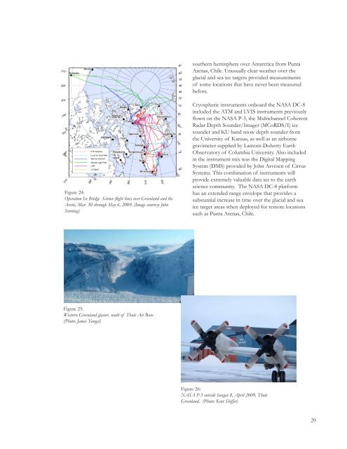
Figure 24:<br />
Operation Ice Bridge <strong>Science</strong> flight lines over Greenland and the<br />
Arctic, Mar. 30 through May 6, <strong>2009</strong>. (Image courtesy John<br />
Sonntag)<br />
Cryospheric instruments onboard the <strong>NASA</strong> DC-8<br />
included the ATM and LVIS instruments previously<br />
flown on the <strong>NASA</strong> P-3, the Multichannel Coherent<br />
Radar Depth Sounder/Imager (MCoRDS/I) ice<br />
sounder and KU band snow depth sounder from<br />
the University of Kansas, as well as an airborne<br />
gravimeter supplied by Lamont-Doherty Earth<br />
Observatory of Columbia University. Also included<br />
in the instrument mix was the Digital Mapping<br />
System (DMS) provided by John Arvesen of Cirrus<br />
Systems. This combination of instruments will<br />
provide extremely valuable data set to the earth<br />
science community. The <strong>NASA</strong> DC-8 platform<br />
has an extended range envelope that provides a<br />
substantial increase in time over the glacial and sea<br />
ice target areas when deployed for remote locations<br />
such as Punta Arenas, Chile.<br />
Figure 25:<br />
Western Greenland glacier, south of Thule Air Base.<br />
(Photo: James Yungel)<br />
Figure 26:<br />
<strong>NASA</strong> P-3 outside hangar 8, April <strong>2009</strong>, Thule<br />
Greenland. (Photo: Kent Shiffer)<br />
29


