QUEST and QUEST West GEOPHYSICAL ... - Geoscience BC
QUEST and QUEST West GEOPHYSICAL ... - Geoscience BC
QUEST and QUEST West GEOPHYSICAL ... - Geoscience BC
Create successful ePaper yourself
Turn your PDF publications into a flip-book with our unique Google optimized e-Paper software.
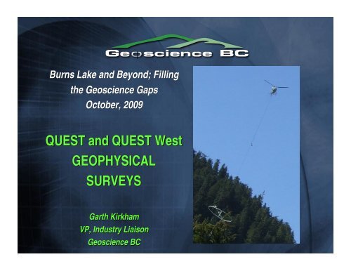
Burns Lake <strong>and</strong> Beyond; Filling<br />
the <strong>Geoscience</strong> Gaps<br />
October, 2009<br />
<strong>QUEST</strong> <strong>and</strong> <strong>QUEST</strong> <strong>West</strong><br />
<strong>GEOPHYSICAL</strong><br />
SURVEYS<br />
Garth Kirkham<br />
VP, Industry Liaison<br />
<strong>Geoscience</strong> <strong>BC</strong>
<strong>QUEST</strong> <br />
<strong>QUEST</strong> <br />
• Airborne Gravity <br />
• Airborne Magnetics <strong>and</strong> <br />
EM
What could we do in a covered <br />
area <br />
Aeromagnetics: <br />
Bedrock lithology, structure <strong>and</strong> alteration <br />
based on magnetite content <br />
Airborne EM <br />
Depth of cover, bedrock lithology, structure, <br />
<strong>and</strong> alteration based on rock conductivity / <br />
resistivity
Gravity <br />
Depth of cover, bedrock lithology, structure, <br />
<strong>and</strong> alteration based on rock density. <br />
The GSC has completed regional ground <br />
gravity at about 10 km station spacing. <br />
• We elected to inJill the regional gravity with <br />
airborne gravity at 2 km line spacing (effectively <br />
about 25 times more (stations
<strong>QUEST</strong> <br />
VTEM: Geotech <br />
Time domain <br />
Helicopter EM <br />
4 km line <br />
spacing <br />
GRAVITY: <br />
S<strong>and</strong>er AirGrav <br />
2 km line <br />
spacing <br />
46,000 km 2
Existing Gravity & Aeromagnetics <br />
GSC Gravity<br />
10 km spacing<br />
GSC Air Mag<br />
800 m spacing
G<strong>BC</strong> Data <br />
Linear amplitude colour scale<br />
Logarithmic amplitude colour scale
G<strong>BC</strong> Data <br />
Linear amplitude colour scale<br />
Logarithmic amplitude colour scale
G<strong>BC</strong> Data <br />
Surficial geology<br />
Lograithmic amplitude colour scale
Example psuedosection of VTEM <br />
data <br />
resistive areas: blue <br />
Overburden conductors: green <br />
Probable conductive bedrock response: red <br />
Image: C. Barnett, BW Mining
Airgrav
<strong>QUEST</strong>- <br />
WEST <br />
<strong>QUEST</strong>-<strong>West</strong>
Airborne Gravity <br />
-‐photos courtesy of Owen Peterson, S<strong>and</strong>er <br />
Geophysics <br />
-‐ Contract to S<strong>and</strong>er Geophysics
S<strong>and</strong>er Geophysics
<strong>QUEST</strong>-‐<strong>West</strong>: Aeroquest ‘AeroTEM’ System <br />
• Aeroquest’s Time Domain <br />
Electromagnetic system, AeroTEM <br />
III, plus aeromagnetic sensor <br />
• Helicopter-‐mounted
<strong>QUEST</strong> WEST Geophysics
<strong>QUEST</strong>-<strong>West</strong> <br />
Orientation Airborne TEM data over 6<br />
deposits<br />
• Morrison, Bell, Granisle, Endako,<br />
• Equity Silver, & Huckleberry<br />
Orientation Airborne ZTEM survey<br />
• Mt. Milligan
MIRA
Data<br />
• Airborne Gravity Data<br />
• Airborne Magnetic Data<br />
• Airborne EM Data
Gravity Data<br />
Terrain Corrected<br />
Bouguer Anomaly<br />
(2.67 g/cm 3 )<br />
mGal<br />
• Airborne acquisition by S<strong>and</strong>er Geophysics<br />
• East-<strong>West</strong> lines with 2000m line spacing<br />
• Regional GSC data also used for regional signal
Magnetic Data<br />
Total Magnetic Intensity<br />
nT<br />
• Airborne acquisition by Geotech<br />
• East-<strong>West</strong> lines with 4000m line spacing<br />
• Regional GSC data also used for regional signal
Electromagnetic Data<br />
Channel 19 dB z /dt data<br />
27 time channels used<br />
~78m flight height<br />
• Airborne acquisition by Geotech (VTEM system)<br />
• East-<strong>West</strong> lines with 4000m line spacing<br />
nT/s
Airborne EM<br />
U<strong>BC</strong>-GIF EM1DTM<br />
Inversion Methods<br />
Inversion for a smoothly varying heterogeneous<br />
1D conductivity distribution<br />
Laterally Parameterized/Constrained Inversion<br />
Neighbouring stations used to determine<br />
appropriate inversion parameters<br />
Reduces modelling artefacts<br />
Background/Late-Time Conductivity<br />
S/m
Airborne EM<br />
3D Interpolation<br />
Inversion Methods<br />
Conformable with topography<br />
Log conductivity [S/m]
Inversion Results<br />
Density Contrast Model<br />
Plan slice at sea level.<br />
g/cm 3
Inversion Results<br />
Density Contrast Model<br />
Plan slice at -2500m elevation.<br />
g/cm 3
Inversion Results<br />
Density Contrast Model - iso-surface cut-off at 0.05 g/cm 3
Inversion Results<br />
Magnetic Susceptibility Model<br />
Plan slice at sea level.<br />
S.I.
Inversion Results<br />
Magnetic Susceptibility Model<br />
Plan slice at -2500m elevation.<br />
S.I.
Inversion Results<br />
Magnetic Susceptibility Model - iso-surface cut-off at 0.05 S.I.
Conductivity Model<br />
Inversion Results<br />
Background Conductivity: Plan View<br />
S/m
Conductivity Model<br />
Inversion Results<br />
Log conductivity [S/m]
Conductivity Model<br />
Zoom<br />
Inversion Results<br />
Log conductivity [S/m]
Inversion Results<br />
Physical Property Classification<br />
• Common 3D Discretization Mesh<br />
• Each Physical Property classified into High, Medium, <strong>and</strong> Low<br />
• Density Contrast <strong>and</strong> Magnetic Susceptibility<br />
Two-phase system 9 classifications<br />
• Density Contrast, Magnetic Susceptibility, <strong>and</strong> Conductivity Background<br />
Three-phase system 27 classifications
3D Physical Property<br />
Classification<br />
Surficial Plan View<br />
Inversion Results
3D Physical Property<br />
Classification<br />
Surficial Plan View<br />
Inversion Results
Using the Results<br />
• Regional Interpretation<br />
• Integrated Interpretation<br />
• Interpretation with Physical Properties<br />
• Constraining Information<br />
• Target Customization<br />
• Survey Design<br />
• Integrated Modelling<br />
• Common Earth Model Development<br />
• 3D GIS Regional Targeting<br />
Qualitative<br />
Quantitative
Using the Results<br />
Quest Block C:<br />
• Conductivity model: East-<strong>West</strong> flight line model sections<br />
• Density Contrast iso-surface at a value of 0.05g/cm3<br />
• North-South magnetic susceptibility section
Using the Results – evaluation of physical property<br />
classification<br />
Distance to known<br />
mineral occurrences.
Using the Results – Den/Sus:<br />
Class 9
Using the Results – Den/Sus/<br />
Con: Class 9
Airborne gravity data<br />
Bouguer anomaly image.<br />
<strong>QUEST</strong>, <strong>QUEST</strong> <strong>West</strong><br />
& GSC Nechako surveys<br />
combined.<br />
100 km


