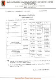
sidhi-singrauli (nh-75e) - Madhya Pradesh Road Development ...
sidhi-singrauli (nh-75e) - Madhya Pradesh Road Development ...
sidhi-singrauli (nh-75e) - Madhya Pradesh Road Development ...

Create successful ePaper yourself
Turn your PDF publications into a flip-book with our unique Google optimized e-Paper software.
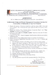
Request for proposal for preparation of feasibility report for four laining with paved shoulder of Sidhi to Singrauli (NH-75E)<br />
(iv)<br />
(v)<br />
Identify stretches, other than those in (iii) above, where intermediate<br />
sight distance is not available. Work out possible improvement plan<br />
to increase the sight distance to provide overtaking sight distance.<br />
Also work out possible improvement plan to increase the sight<br />
distance to provide at least the intermediate sight distance.<br />
Identify stretches where the gradients are steeper than the ruling<br />
gradient for the relevant terrain condition. Work out and prepare an<br />
improvement plan for the vertical alignment in such stretches.<br />
Divide improvement plans of such stretches into the following two<br />
parts:<br />
−<br />
−<br />
Stretches where gradient is more than the limiting gradient<br />
(The Authority can take a view on whether improvements of<br />
stretches in this category shall be taken up or not.)<br />
Stretches where gradient is more than the ruling gradient but<br />
less than the limiting gradient.<br />
(vi)<br />
Identify stretches where extra width of roadway and carriageway at<br />
curves is required.<br />
(f)<br />
(g)<br />
(h)<br />
Identify stretches involving construction of new bridges and other grade<br />
separated structures including those requiring reconstruction and their<br />
approaches. Work out proposal for location of such structures and<br />
alignment of approaches.<br />
Based on the improvement plans of horizontal and vertical alignment<br />
worked out as a result of tasks in (d), (e) and (f), prepare alignment plans,<br />
L-Sections and cross-sections of the entire Project Highway. Scale of<br />
drawings shall be as per IRC:SP:19. Proposed improvements shall be<br />
marked on the plans. Such improvements will include raising of road,<br />
widening of roadway, widening of existing carriageway, provision of<br />
shoulders – both paved and granular, new structures, underpasses, grade<br />
separators, service roads, additional road signs, road furniture, safety<br />
devices, relocation of utilities, removal of trees, etc.<br />
Also prepare a separate Land Plan of the Project Highway showing the<br />
existing ROW (alongwith all the existing assets within the ROW e.g.<br />
structures, drains, service roads, trees, utilities and safety devices) and<br />
proposed additional land required in various stretches for improvement of<br />
geometrics, construction of new structures, provision of intersections,<br />
interchanges, service roads, toll plazas, project facilities, etc. The Land Plan<br />
should also show encroachments, if any. A list of such encroachments