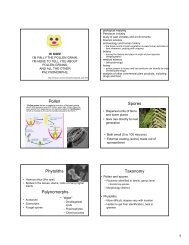
Scroll bars (ridge and swale, meander scrolls)
Scroll bars (ridge and swale, meander scrolls)
Scroll bars (ridge and swale, meander scrolls)

You also want an ePaper? Increase the reach of your titles
YUMPU automatically turns print PDFs into web optimized ePapers that Google loves.
<strong>Scroll</strong> <strong>bars</strong> (<strong>ridge</strong> <strong>and</strong> <strong>swale</strong>, me<strong>and</strong>er<br />
<strong>scrolls</strong>)
• Longitudinal bar<br />
• Low <strong>ridge</strong> of sediment on inside of<br />
me<strong>and</strong>er bend during bankfull flow<br />
• Flow recedes, vegetation
Or<br />
• Flow separation over<br />
point bar during<br />
single flood—<br />
deposition<br />
• Eventually vegetated<br />
• 30 yrs ()
Point bar <strong>and</strong> floodplain formation of the<br />
me<strong>and</strong>ering Beatton River, northeastern British<br />
Columbia, Canada. (1979) G. Nanson,<br />
Sedimentology, v.27, n 1., 3-29 (quoted)<br />
• Initial point bar platform (mainly coarse sediment) formed adjacent<br />
to the convex bank of a migrating me<strong>and</strong>er bend.<br />
• Is the base for a single scroll bar of fine traction <strong>and</strong> suspended<br />
load. <strong>Scroll</strong> bar grows, eventually supporting vegetation <strong>and</strong><br />
becoming a floodplain <strong>ridge</strong>.<br />
• Form with greatest size <strong>and</strong> frequency in rapidly migrating bends<br />
• Shape of the me<strong>and</strong>er bend appears to determine both the location<br />
of the initial bar deposit, <strong>and</strong> its direction of growth up or<br />
downstream.<br />
• Initiation of a scroll bar appears to be due to excessive deposition of<br />
suspended load in a zone of flow separation over a point bar<br />
platform.<br />
– critical flow condition for the initiation of a scroll bar does not occur with<br />
the same recurrence interval on different shaped me<strong>and</strong>er bends!<br />
– average recurrence interval ~ 30 years<br />
• Despite 2–3 m of overbank deposition, the amplitude of floodplain<br />
<strong>ridge</strong>s is maintained by secondary currents which sweep sediment<br />
from the <strong>swale</strong>s towards the <strong>ridge</strong> crests.
New evidence of scroll-bar formation on the<br />
Beatton River (1981) G. Nanson, Sedimentology, v.<br />
28, n. 6, 889-891<br />
• “observations… suggest that an initial<br />
scroll bar may form around a str<strong>and</strong>ed<br />
dead tree that acts as a sedimentation<br />
nucleus on a point-bar platform”
Swales exploited during high flow<br />
• Develop into chutes<br />
• Counteract sediment redistribution from<br />
<strong>ridge</strong>s
Mississippi entered union 1817
Levees<br />
• Generally hundreds of m wide<br />
• Slope away from channel<br />
• V decreases as waters overtop bank<br />
• Coarse sediment deposited adjacent to channel<br />
– 53 cm levee, 1 cm backswamp (MS) (depends on V<br />
decrease)
Distal floodplains<br />
• Subdued topography<br />
– Oxbows<br />
• Clay plug<br />
– Splay deposits<br />
• Can get coarse<br />
sediments!<br />
– Cohesive banks<br />
• Complex mosaics!<br />
– Lateral migration 0-2460<br />
ft/yr (lots in the 10s to<br />
100s)<br />
muller.lbl.gov
http://www.geo.uu.nl/fg/berendsen/pictures/photography/alaska/Crevasse.jpg
http://www.geo.uu.nl/fg/palaeogeography/pictures/results_avulsion<br />
s/01_Development_avulsion.png<br />
http://www.geo.uu.nl/fg/palaeogeography/results/avulsions
Floodplain evolution/formation<br />
• Sediment “conserved” during me<strong>and</strong>er<br />
migration<br />
– Bank erosion = point bar accumulation<br />
• Vertical accretion decreases w/time<br />
– Takes flood w/longer recurrence interval to<br />
overtop banks<br />
• Lateral migration rates far exceed vertical<br />
accumulation (overbank flow) rates<br />
– “dominant process”
• Incision can outpace bank erosion
What’s a terrace<br />
• Ab<strong>and</strong>oned floodplain<br />
– Recurrence interval of flooding<br />
• Composed of<br />
– Tread<br />
–Scarp<br />
• May be erosional or depositional features<br />
– Erosional: bench, strath, rock-cut<br />
• Control: tectonic<br />
– Depositional: Fill<br />
• Control: climatic
• Depositional: All treads in alluvium<br />
– First incision, then aggradation, then incision<br />
• Alluvium= *temporary* sediment storage<br />
– Sed production> Sed transport
Erosional terraces<br />
• …”One sometimes wonders if any aspect of<br />
fluvial processes escaped the genius of<br />
G.K. Gilbert”.
• Formed during lateral migration<br />
• Depth of alluvial deposit < scour depth of<br />
river<br />
• *Usually* requires<br />
–Time<br />
– Steady base-level<br />
– Constant climate
Desert processes
Ralph A. Bagnold (1896-1990)<br />
• Officer, British Royal Army of Engineers<br />
• Stationed in Cairo between world wars<br />
• Founded the LRDG<br />
• In spare time, wrote “The physics of blown<br />
s<strong>and</strong> <strong>and</strong> desert dunes”
• Deserts in:<br />
More than just s<strong>and</strong>…<br />
– North America: 2% s<strong>and</strong> cover<br />
– North Africa (Sahara) 10% s<strong>and</strong> cover<br />
– Arabia: 50% s<strong>and</strong> cover
Wind!<br />
• Unequal heating of surface<br />
• Winds pick up during day to 10-20 mph<br />
• Governed by same fluid flow principles as H 2 O<br />
• Mostly turbulent; HOWEVER, usually laminar<br />
layer at base (~1mm)<br />
• Also layer where v=0<br />
– 1/30 grain diameter for flat surface of same size<br />
grains<br />
• Relate erosional potential of wind to<br />
– Velocity, particle size
Wind velocity<br />
• Increases with height<br />
•V z = 5.75 V * log (z/k)<br />
•V z ; velocity at height z<br />
•V * ; drag/friction velocity;<br />
surface friction speed<br />
• K ; surface roughness<br />
constant (height of v=0<br />
zone)<br />
• Increasing V * increases<br />
shear on particle<br />
τ=ρ V *2 ρ=density air<br />
• k varies dramatically<br />
(ocean, 1mm to city, 5 m)
Role of turbulence<br />
• Creates some upward velocity<br />
• Generally Vup = 1/5 V<br />
• If a particle’s settling velocity < 1/5 V,<br />
transport downwind<br />
• Turbulence typical<br />
• Eddies in many directions<br />
• When hot, convection drives upward<br />
plumes
Entrainment<br />
• Can determine threshold friction velocity<br />
– Surface roughness<br />
– Soil moisture<br />
– Salt precipitation<br />
– Resistant crusts<br />
• Threshold value of friction velocity: (for air,<br />
A =0.1)<br />
V<br />
∗τ<br />
=<br />
A<br />
ρs<br />
− ρa<br />
ρ<br />
a<br />
gD<br />
• Avg. desert s<strong>and</strong>, threshold = 16 km/h
Modes of transport<br />
• Image courtesy of “Manurenet”<br />
• Surface creep also known as “reptation”
Suspension<br />
• Upward velocity (wind) exceeds downward<br />
velocity (gravity vs. drag)<br />
• Restricted to silt <strong>and</strong> clay
Saltation<br />
• Larger particles, discontinuous “bouncing”<br />
• Once motion begins, surface is<br />
bombarded<br />
– Particles moved at lower wind velocities<br />
– “new” Impact threshold