AERONAUTICAL NAVIGATOR - AEROSHOP.eu
AERONAUTICAL NAVIGATOR - AEROSHOP.eu
AERONAUTICAL NAVIGATOR - AEROSHOP.eu

You also want an ePaper? Increase the reach of your titles
YUMPU automatically turns print PDFs into web optimized ePapers that Google loves.
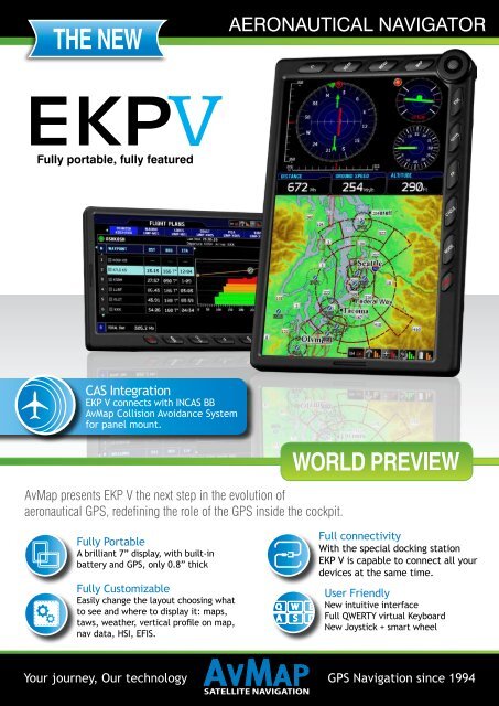
<strong>AERONAUTICAL</strong> <strong>NAVIGATOR</strong><br />
Fully portable, fully featured<br />
CAS Integration<br />
EKP V connects with INCAS BB<br />
AvMap Collision Avoidance System<br />
for panel mount.<br />
AvMap presents EKP V the next step in the evolution of<br />
aeronautical GPS, redefining the role of the GPS inside the cockpit.<br />
Fully Portable<br />
A brilliant 7” display, with built-in<br />
battery and GPS, only 0.8” thick<br />
Fully Customizable<br />
Easily change the layout choosing what<br />
to see and where to display it: maps,<br />
taws, weather, vertical profile on map,<br />
nav data, HSI, EFIS.<br />
Full connectivity<br />
With the special docking station<br />
EKP V is capable to connect all your<br />
devices at the same time.<br />
User Friendly<br />
New intuitive interface<br />
Full QWERTY virtual Keyboard<br />
New Joystick + smart wheel<br />
Your journey, Our technology GPS Navigation since 1994
<strong>AERONAUTICAL</strong> <strong>NAVIGATOR</strong><br />
Connectivity:<br />
Thanks to the special Docking Station, you can connect EKP V to<br />
several on-board devices at the same time (autopilot, XM WX, CAS,<br />
EIS, EFIS etc.) so that the large 7” LCD becomes multifunctional<br />
and capable to display different flight info.<br />
Slim and light, yet very powerful:<br />
EKP V comes with built in u-blox 5 GPS receiver, built-in battery and<br />
speaker. The practical keyboard includes a configurable key, a new<br />
progressive jostick and a smart wheel selector. Ease of use ensured<br />
by the new graphic interface and the full QWERTY virtual keyboard.<br />
HARDWARE<br />
• Dimensions: 4.3” x 6.8” x 0.8”<br />
• Weight: 14 Oz<br />
• Display size: 7” (16:9) 4.75” x 7” x 1.5”<br />
• Display type: Color LCD TFT<br />
• Display resolution: 800 x 480 pixels<br />
• Keyboard with 10 keys with F1 configurable key<br />
• Progressive Joystick + smart wheel selector<br />
• GPS receiver: built-in u-blox 5 high sensitivity with WAAS position accuracy<br />
• RAM: 256 MB<br />
• Memory Support: Micro SD preloaded with software and maps<br />
• Black Box function: last 10 minutes flight data record<br />
• Power supply: external 10/35 V DC with cable adapter<br />
• Battery: removable, rechargeable lithium-Ion<br />
• Consumption: max 10 Watt<br />
• Speaker<br />
• USB OTG master / slave<br />
Docking Station:<br />
• For panel mount with 2 serial ports and 1 USB OTG master / slave<br />
• Audio Video input<br />
• Audio output<br />
SOFTWARE Features<br />
• Horizontal / Vertical view<br />
• Night Vision<br />
• Vertical profile on map<br />
• Flight plan vertical profile: you can set the waypoints altitude<br />
• Full flight planning capability (up to 15 flight plans of up to 100 legs each)<br />
• Editable aircraft checklist<br />
• Full simulator functions<br />
• Fully customizable display: choose what to see and where! TAWS, weather,<br />
vertical profile, nav data, HIS, EFIS (GPS based).<br />
• Integration with other onboard devices: EFIS, autopilot, external antenna,<br />
WXXM, CAS<br />
• TAWS: Terrain Awareness and Warning System available worldwide<br />
• Crossed Airspace Predictor and Advisor<br />
• Safe Route predictor and advisor<br />
• Full qwerty virtual keyboard<br />
• Customizable aircraft PROFILES; set a profile for each aicraft with different<br />
TAWS settings, selective display etc<br />
• Selective display<br />
• Compatible with AvMap INCAS BB or other Collision Avoidance Systems<br />
• Compatible with XM Satellite Weather*<br />
• Save waypoints and tracks and view them in Google Earth<br />
MAPS<br />
• Worldwide background<br />
• Jeppesen database<br />
• TAWS<br />
• Obstacles data<br />
• AOPA directory<br />
• Low Airways<br />
• Private Airports<br />
• Approach plates<br />
• Airport diagrams for Taxi<br />
navigation<br />
*Service avilable in North America only<br />
Try also INCAS by AvMap<br />
The Collision Avoidance System by AvMap<br />
3.5” Sunlight<br />
readable display<br />
Serial output<br />
Communication range<br />
from 5 to 70 Nm<br />
Built-in altimeter,<br />
magnetic compass<br />
and GPS<br />
Audio voice alerts<br />
Mode-S / ADS-B<br />
Technology<br />
Available also in Blackbox version compatible with EKP V<br />
100% Made in Europe<br />
www.avmap.us