analysis of seasonal extreme flows using peaks over threshold method
analysis of seasonal extreme flows using peaks over threshold method
analysis of seasonal extreme flows using peaks over threshold method

Create successful ePaper yourself
Turn your PDF publications into a flip-book with our unique Google optimized e-Paper software.
Analysis <strong>of</strong> <strong>seasonal</strong> <strong>extreme</strong> <strong>flows</strong> <strong>using</strong> Peaks <strong>over</strong> <strong>threshold</strong> <strong>method</strong><br />
activities. Vörösmarty and Sahagian (2000) noted<br />
that increases in run<strong>of</strong>f may be attributable to human<br />
alterations such as conversion from forest to<br />
agricultural land uses. In contrast, reforestation<br />
could result in decreases in run<strong>of</strong>f. However, in<br />
spite <strong>of</strong> abandonment <strong>of</strong> cultivated farmlands and<br />
conversion to forest or pasture, increases in run<strong>of</strong>f<br />
due to intensification <strong>of</strong> the water cycle has been<br />
documented by Milly and Dunne (2001).<br />
In other cases, measured data indicates decrease<br />
or no changes in magnitude and flood frequency<br />
(Aizen et al., 1997; Zhang et al., 2001; Holko and<br />
Kostka, 2005). Sharma and Shakya (2006) concluded<br />
that the magnitude <strong>of</strong> flood is decreasing but<br />
its frequency and duration are increasing.<br />
Although climate change is a global phenomenon<br />
the trends and impact may be different at a local<br />
scale. Analysis should be done at the local level<br />
rather than at the large scale (Sharma and Shakya,<br />
2006). Flash floods caused by intensive rainfall<br />
events occurred in the last years in small basins in<br />
Slovakia (Grešková, 2005). The results presented<br />
by Svoboda and Pekárová (1998) show that in the<br />
Carpathian flysh region an intensive rainfall <strong>over</strong><br />
a small catchment sufficiently wetted by the antecedent<br />
even moderate precipitation can cause 500-<br />
year return period flood which can not be effectively<br />
reduced neither by retention capacity <strong>of</strong> the<br />
shallow soil nor by interception <strong>of</strong> a dense and<br />
healthy forest.<br />
The annual maximum series approach is the most<br />
frequently used <strong>method</strong> for probabilistic assessment<br />
<strong>of</strong> design <strong>flows</strong>. The annual maximum series considers<br />
only one value per year, i. e. annual maximum<br />
(AM). However, the use <strong>of</strong> an AM series may<br />
involve some loss <strong>of</strong> information. For example, the<br />
second or third peak within a year may be grater<br />
than maximum flow in other years and yet they are<br />
ignored (Kite, 1977; Chow et al., 1988). This situation<br />
is avoided in the <strong>peaks</strong> <strong>over</strong> <strong>threshold</strong> (POT)<br />
<strong>method</strong> where all <strong>peaks</strong> above a certain base value<br />
are considered (Bayliss, 1999; Rao and Hamed,<br />
2000; Black and Burns, 2002; Ouarda et al., 2006).<br />
More<strong>over</strong>, POT <strong>method</strong> allows detection <strong>of</strong><br />
changes in the frequency <strong>of</strong> occurrence <strong>of</strong> <strong>extreme</strong><br />
floods or hydrological events in different seasons.<br />
The purpose <strong>of</strong> the paper is to analyse changes in<br />
occurrence frequency <strong>of</strong> <strong>extreme</strong> hydrological<br />
events in a small basin in the flysh region <strong>over</strong> the<br />
period <strong>of</strong> 40 years. POT <strong>method</strong> was applied separately<br />
to winter and summer hydrological halfyears.<br />
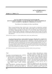
Study area<br />
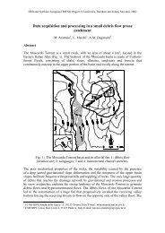
The study focuses on the agricultural micro-basin<br />
Rybárik, near Považská Bystrica (Western Slovakia,<br />
Central Europe) (Fig. 1). The Rybárik basin is<br />
a part <strong>of</strong> the experimental Mošteník brook basin<br />
and is bounded by latitude 49°06′N and 49°07′N;<br />
RYBÁRIK<br />
Jel ové<br />
Legend<br />
Gauging Station<br />
Forest<br />
Watershed Boundary<br />
0 100 200 300 400 500 m<br />
Fig. 1. The experimental Rybárik basin.<br />
Obr. 1. Experimentálne povodie Rybárik.<br />
17