Volume 35 Issue 1 Summer 2010 - Confederation of Bushwalking ...
Volume 35 Issue 1 Summer 2010 - Confederation of Bushwalking ...
Volume 35 Issue 1 Summer 2010 - Confederation of Bushwalking ...

You also want an ePaper? Increase the reach of your titles
YUMPU automatically turns print PDFs into web optimized ePapers that Google loves.
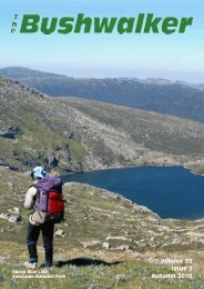
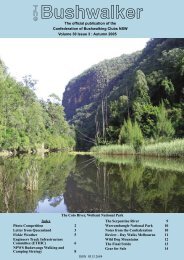
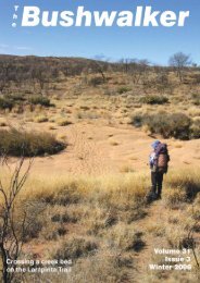
Crossing Coxs River<br />
below Mt Thomas Jones,<br />
Blue Mts NP<br />
<strong>Volume</strong> <strong>35</strong><br />
<strong>Issue</strong> 1<br />
<strong>Summer</strong> <strong>2010</strong>
Photo: Trevor Henderson,<br />
Newcastle <strong>Bushwalking</strong> Club<br />
Genoa River,<br />
Victoria<br />
Contributions <strong>of</strong> interesting, especially typical and spectacular bushwalking photos are sought.<br />
you don’t want the same photographers all the time, do you<br />
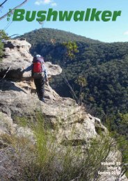
Photo: Roger Caffin<br />
Camp at Four Ways,<br />
Upper Geehi River,<br />
Kocsiusko NP
T<br />
h<br />
eBushwalker<br />
The Official Publication <strong>of</strong> the<br />
<strong>Confederation</strong> <strong>of</strong> <strong>Bushwalking</strong> Clubs NSW<br />
<strong>Volume</strong> <strong>35</strong>, <strong>Issue</strong> 1, <strong>Summer</strong> <strong>2010</strong><br />
ISSN 0313 2684<br />
Editor: Roger Caffin<br />
editor@bushwalking.org.au<br />
Graphic Design & Assembly:<br />
Barry Hanlon<br />
<strong>Confederation</strong> Officers:<br />
President: Dodie Green<br />
Administration Officer:<br />
admin@bushwalking.org.au<br />
Website: www.bushwalking.org.au<br />
Address all correspondence to:<br />
PO Box 119, Newtown, NSW 2042<br />
The <strong>Confederation</strong> <strong>of</strong> <strong>Bushwalking</strong><br />
Clubs NSW Inc represents<br />
approximately 66 Clubs with a total<br />
membership <strong>of</strong> about 8,700<br />
bushwalkers.<br />
Formed in 1932, the <strong>Confederation</strong><br />
provides a united voice on behalf <strong>of</strong> all<br />
bushwalkers on conservation, access<br />
and other issues.<br />
People interested in joining a bushwalking<br />
club may write to the<br />
<strong>Confederation</strong> Administration<br />
admin@bushwalking.org.au<br />
for a list <strong>of</strong> Clubs, but a far more<br />
useful on-line list is available at the<br />
<strong>Confederation</strong> website<br />
www.bushwalking.org.au,<br />
broken up into areas. There’s lots <strong>of</strong><br />
other good stuff there too, including<br />
the bushwalking FAQ.<br />
From the<br />
editor’s desk. . .<br />
Walk Safely—Walk with a Club<br />
One <strong>of</strong> the articles in this issue is a continuation <strong>of</strong> the Adventure<br />
Activities Standards (AAS) saga. My thanks to Leonie Bell for the<br />
article. I have added to the article an extract from the Minutes <strong>of</strong><br />
the <strong>Confederation</strong> covering this. Further contributions on the subject will<br />
be happily accepted.<br />
However, you will have to suffer another addition to this article, this time<br />
from me. Don flack jackets, because I have spoken a little bit <strong>of</strong> my mind<br />
on this. In my opinion, the entire AAS thing is mindless bureaucracy being<br />
driven by vested interests with zero knowledge <strong>of</strong> Club <strong>Bushwalking</strong>.<br />
Furthermore, I do not accept that the Standards have any relevance or<br />
applicability to <strong>Confederation</strong> Clubs. I would argue that we should simply<br />
inform the AAS people that we do not accept that they have any legal<br />
applicability to clubs <strong>of</strong> volunteers. We should not lie down and be driven<br />
over.<br />
I do agree that the AAS may be needed to bring commercial<br />
adventure/quick-thrill organisations under control, and to improve the<br />
way parties <strong>of</strong> school children and church groups are taken into the bush,<br />
but those are situation <strong>of</strong> for-pr<strong>of</strong>it where there is a legal duty <strong>of</strong> care.<br />
The organisers <strong>of</strong> those situations are presenting themselves as being<br />
competent to lead ‘customers’. Europe, New Zealand and even America<br />
have pr<strong>of</strong>essional Guides Associations to handle these things, but in none<br />
<strong>of</strong> those countries do the ‘authorities’ make any attempt to even imagine<br />
that they could or should have anything to do with volunteer clubs or<br />
individuals.<br />
There is more, but you will have to read the article.<br />
Articles for Publication<br />
Clubs and members are encouraged to submit relevant articles, with a very strong<br />
preference for those with good pictures. Both the author and the author’s club will<br />
feature in the Byline - this is a good way to advertise YOUR club. We will also accept<br />
articles from outside bodies where the articles seem relevant to members.<br />
Articles may be edited for length and content to help fit into our page limit. Pictures<br />
should be sent at maximum available resolution: at least 300 dpi, preferably in their<br />
original unedited form. JPG, PDF or TIFF formats are preferred. The text should be<br />
sent as a plain text file (*.txt), NOT as a Word file (*.doc). I repeat, please send<br />
the pictures separate from the text file; do NOT send them embedded in a Word doc<br />
file. Pictures taken from a Word doc file are simply not good enough and won’t be<br />
published. And, <strong>of</strong> course, the Editor is always interested in receiving bushwalking<br />
books and maps for review. All enquiries should be sent to editor@bushwalking.org.au.<br />
Please note that opinions expressed by authors may not represent the <strong>of</strong>ficial opinions<br />
<strong>of</strong> the <strong>Confederation</strong> or any Club. The Editor’s opinions are his own.<br />
Roger Caffin<br />
Editor<br />
Subscribe to The Bushwalker<br />
Keep up with all the news and developments<br />
happening in the NSW bushwalking scene for<br />
only $10 per year. This is to cover posting and<br />
handling: the magazine itself is free.<br />
Send your name and address and cheque or<br />
money order to the <strong>Confederation</strong> <strong>of</strong> <strong>Bushwalking</strong><br />
Clubs NSW Inc, PO Box 119, Newtown<br />
NSW 2042. The new phone number is<br />
9565 4005. Make the cheque or money order<br />
payable to the <strong>Confederation</strong> <strong>of</strong> <strong>Bushwalking</strong><br />
Clubs NSW Inc as well: please do not abbreviate<br />
the name!<br />
Please indicate which issue you want your subscription<br />
to start with. We don’t want to duplicate<br />
copies you already have.<br />
Index<br />
Don’t you wish you were here 2<br />
From the Editor’s Desk 3<br />
Exploring more <strong>of</strong> the Wolgan Capertee Divide 4<br />
Two Weeks in the Corbières - SW France 7<br />
Martindale Creek 9<br />
Mt Bartle Frere and Hinchinbrook Island 11<br />
Adventure Activity Standards 13<br />
Extract From Federation Minutes 15<br />
Editorial Comment 15<br />
Errata: The article in the last issue on Mt Kinabalu had the wrong author.<br />
Both the article and the photos come from Steve Deards. Our apologies about this.<br />
<strong>Volume</strong> <strong>35</strong>, <strong>Issue</strong> 1, <strong>Summer</strong> <strong>2010</strong><br />
The Bushwalker | 3
Walk Safely—Walk with a Club<br />
Exploring more<br />
<strong>of</strong> the Wolgan<br />
Capertee<br />
Divide<br />
Michael Keats,<br />
The Bush Club<br />
Grass trees by the ton<br />
Joseph Edmund Carne, Assistant Government<br />
Geologist, in his ‘Geology<br />
and Mineral Resources <strong>of</strong> the Western<br />
Coalfield, 1908’ makes reference to<br />
the ‘Blue Rocks’. On page 245 <strong>of</strong> this<br />
weighty tome he writes,<br />
‘Blue Rocks consists <strong>of</strong> a massive outcrop<br />
<strong>of</strong> greyish – blue limestone, with a vertical<br />
face about 300 feet in height, which has<br />
been caused by the undermining and<br />
solvent action <strong>of</strong> the water <strong>of</strong> Crown<br />
Swamp Creek along a joint plane. The<br />
water disappears at this point, and is not<br />
seen above ground for about 3 miles,<br />
where it trickles over bars <strong>of</strong> travertine.’<br />
The reference continues with an<br />
assessment <strong>of</strong> the economics <strong>of</strong> exploiting<br />
the deposit (fortunately not viable even in<br />
1908) and a detailed chemical analysis.<br />
The Geological map <strong>of</strong> Portion <strong>of</strong> the<br />
Capertee and Wolgan Valleys, JE Carne<br />
1901 shows the extent <strong>of</strong> this small<br />
deposit, which is located on the eastern<br />
edge <strong>of</strong> Portion 58 <strong>of</strong> the Parish <strong>of</strong><br />
Goollooinboin. It also outcrops on Crown<br />
Creek.<br />
Of significant interest to bushwalkers<br />
and shown on the same map is an old<br />
bridle track that commences west <strong>of</strong><br />
Crown Creek on the north west slopes <strong>of</strong><br />
Pantoneys Crown, crosses Crown Creek<br />
eastwards through portion 52, heads<br />
south up an extended northern spur from<br />
Mount Stewart for about 4.5 km before it<br />
enters and then passes through the<br />
Hughes Defile emerging on the talus slope<br />
in the Wolgan Valley.<br />
Direct access to this area is now<br />
effectively closed to the public by<br />
privately held land, so the question was<br />
how to gain access and take a party <strong>of</strong><br />
walkers to visit the Blue Rocks and<br />
experience walking the historic bridle<br />
trail. Using my network <strong>of</strong> contacts<br />
suitable arrangements were made. It<br />
should be noted each <strong>of</strong> these iconic<br />
destinations can be reached by walking in<br />
from McLeans Pass to the west, but a 3-<br />
day walk would be needed and carrying<br />
sufficient water would be an issue. The<br />
area is a bit dry.<br />
The Crown Creek road drive down<br />
through the properties traversed typical<br />
glorious scenery <strong>of</strong> the NSW Central West.<br />
It was so dramatic that I stopped<br />
frequently to capture images so good they<br />
could not be passed by – unique ancient<br />
gums, glowing sandstone cliffs, serried<br />
rolling wooded hills, dry creeks and<br />
waving native grasses, and, in the blue<br />
distance a pr<strong>of</strong>iled skyline definitive <strong>of</strong><br />
the Capertee Valley. I was captivated.<br />
At 0940 we parked at the NP&WS<br />
locked gate. It is quite anomalous in that<br />
for the remainder <strong>of</strong> the road private ‘inholdings’<br />
alternate with land under the<br />
control <strong>of</strong> the NP&WS. After briefing and<br />
checking water supplies we starting<br />
walking south at 0950 through surveyed<br />
portions 55, 56, 57 and 58 along the road,<br />
passing the junction with the Meadows<br />
Trail near portion 57.<br />
From about this point we could see the<br />
stunning cliffs <strong>of</strong> the Blue Rock and the<br />
unique flora dominated by Xanthorrheas.<br />
At 1015 we stood in the shade at the base<br />
<strong>of</strong> the Blue Rock – a shear wall <strong>of</strong><br />
limestone rising almost 100 m (Carne's<br />
300 feet) from the valley floor. We<br />
stopped here in the shade for morning<br />
tea.<br />
While having morning tea we observed<br />
the very different vegetation that clothes<br />
the face <strong>of</strong> the Blue Rock. The largest<br />
species are Figs (Ficus sp) and Kurrajongs<br />
(Brachychiton populneus). We also noted<br />
that the presence <strong>of</strong> Xanthorrhea sp,<br />
which delineate the limestone outcrop<br />
boundary. A range <strong>of</strong> smaller plants was<br />
also observed but there was no time to<br />
carry out an audit. Suffice to say the<br />
vegetation on the limestone is in stark<br />
contrast to the surrounding area.<br />
Morning tea break over we ascended a<br />
long ramp to the east that leads all the<br />
way to the top <strong>of</strong> the Blue Rock.<br />
Unfolding views were special in every<br />
direction. Never to be forgotten views <strong>of</strong><br />
the Tayan Pic (to the far north) and<br />
Pantoneys Crown (immediately west)<br />
were enjoyed. On the top <strong>of</strong> the cliff the<br />
Xanthorrheas were interspersed with<br />
viciously spined Spinifex sp These two<br />
species delineate the massive limestone<br />
area.<br />
Leaving the top <strong>of</strong> the Blue Rock we<br />
followed a saddle and then crossed a<br />
series <strong>of</strong> ridges following the contours on<br />
what appeared to be a well-frequented<br />
animal track. From observed droppings<br />
we think it is probably a wild goat track.<br />
The numerous vegetation changes were<br />
Orchid Dipodium<br />
punctatum<br />
The top <strong>of</strong><br />
Blue Rock<br />
4 | The Bushwalker <strong>Volume</strong> <strong>35</strong>, <strong>Issue</strong> 1, <strong>Summer</strong> <strong>2010</strong>
Heading up around Mt Stewart<br />
frequent and distinct. We passed through<br />
stands <strong>of</strong> White Box, Iron Bark and<br />
Cypress interspersed with the ever present<br />
Xanthorrheas and Spinifex. At times we<br />
observed complete hillsides covered in<br />
nothing but Xanthorrheas.<br />
Progressing along this track the views<br />
over the Capertee Valley are magnificent.<br />
As we rounded the northern extension <strong>of</strong><br />
a spur <strong>of</strong> Mount Stewart, the<br />
Xanthorrheas disappeared, the<br />
understorey became scrappy, and at times<br />
unpleasant. We walked up a couple <strong>of</strong><br />
false gullies thinking we were entering<br />
into the northern end <strong>of</strong> Hughes Defile.<br />
These gullies were dry beyond the<br />
imagination and as the day continued to<br />
warm up the rock sections reflected the<br />
rising heat. Our water consumption rose.<br />
At 1140 we picked up the<br />
unmistakable line <strong>of</strong> the old bridle track.<br />
Looking upwards, the exposed rocky<br />
pr<strong>of</strong>ile <strong>of</strong> Mount Stewart was very<br />
conspicuous while the ground under our<br />
feet was now devoid <strong>of</strong> even soil cover. It<br />
was harsh, dry and barren. Anxious to<br />
reach the shade and hopefully cooler<br />
conditions within the defile we pushed on<br />
losing and then finding what could be<br />
remnants <strong>of</strong> the old trail. Given that over<br />
100 years has elapsed since it was in<br />
active use, we did rather well.<br />
The rate <strong>of</strong> climb in the defile is<br />
continuous and nearly 400 m <strong>of</strong> elevation<br />
are gained over 2.5 km. There are many<br />
sections <strong>of</strong> bare rock and very deep, dry<br />
and slippery groundcover <strong>of</strong> old leaves<br />
and bark. It is not until you actually enter<br />
the throat <strong>of</strong> the defile that the rate <strong>of</strong><br />
climb eases and the vegetation changes<br />
once more. Under normal circumstances<br />
the defile would be a beautiful place with<br />
epiphytic encrusted rocks and carpets <strong>of</strong><br />
Blechnum sp ferns. On the day it was<br />
desiccated and most species showed signs<br />
<strong>of</strong> Aextreme water stress.<br />
bout half way along Hughes Defile we<br />
found what we believe to be the<br />
recently deceased remains <strong>of</strong> a Greater<br />
Glider (1) (Petaurides volans). Much <strong>of</strong> the<br />
animals fur was still intact and it was<br />
photographed. The shape <strong>of</strong> the head and<br />
Walk Safely—Walk with a Club<br />
The limestone face <strong>of</strong> Blue Rock<br />
the general specifications seemed to be<br />
right.<br />
At 1310 we arrived at the crest (and<br />
watershed) within Hughes Defile. It is<br />
remarkable for being dominated by a<br />
large, centrally positioned, almost circular<br />
sandstone boss (pagoda) about 30 m high<br />
and about the same diameter, with an<br />
even more remarkable continuous cave<br />
right around the circumference. The cave<br />
has been used for camping, and going by<br />
<strong>Volume</strong> <strong>35</strong>, <strong>Issue</strong> 1, <strong>Summer</strong> <strong>2010</strong><br />
The Bushwalker | 5
Walk Safely—Walk with a Club<br />
It was hot, and dry<br />
found newspaper evidence was visited on<br />
the ANZAC weekend in 2001. (2) From the<br />
website archives <strong>of</strong> Sydney University<br />
Bushwalkers we know it was also visited<br />
on the June weekend in 2006 when<br />
conditions were freezing cold and wet.<br />
[The Editor passed through here in 2000.]<br />
The cave provided welcome shade and<br />
a good place for lunch. A quick walk<br />
around the cave revealed that the descent<br />
down into the Wolgan Valley is much<br />
steeper than the ascent from the Capertee<br />
Valley side. After lunch left our packs<br />
walked across the saddle extension to the<br />
east. Here in an overhang was a small<br />
cairn marking a unique pass up through a<br />
canyon like slot onto the pagodas above.<br />
It is a short climb to the top where the<br />
views are rewarding.<br />
Turning the head south provided a<br />
good view over part <strong>of</strong> the Wolgan Valley<br />
and the phallic, bare rock protuberance <strong>of</strong><br />
Cape Horn; turning the head north was a<br />
view <strong>of</strong> the pagoda-edged alignment <strong>of</strong><br />
Hughes Defile and the spread <strong>of</strong> the<br />
Capertee Valley. Took photos but the haze<br />
made for poor definition <strong>of</strong> the images.<br />
Returned to the cave and retrieved our<br />
packs before starting out on the return<br />
journey. At least in the heat <strong>of</strong> the day we<br />
were<br />
A<br />
headed down hill.<br />
s we descended passed now familiar<br />
features and at 1520 intersected first<br />
with a fence and then with the Meadows<br />
Fire Trail. From here we continued<br />
walking west into an ever-hotter sun and<br />
down the trail (a 4WD track). We saw<br />
many inter-bedded layers <strong>of</strong> limestone in<br />
the roadside cuttings and a return <strong>of</strong> the<br />
Xanthorrheas. We also noted some serious<br />
new fencing and gates installed by the<br />
NP&WS designed to discourage<br />
unauthorised traffic. After allowing<br />
numerous drink stops we arrived back at<br />
the vehicles at 1600. t<br />
1 NP&WS ID from photographs<br />
2 A copy <strong>of</strong> the Australian Newspaper had been left<br />
under a rock<br />
The pagoda in Hughes Defile<br />
6 | The Bushwalker <strong>Volume</strong> <strong>35</strong>, <strong>Issue</strong> 1, <strong>Summer</strong> <strong>2010</strong>
Walk Safely—Walk with a Club<br />
Rodney Hills,<br />
Batemans Bay Bushwalkers<br />
Walking group on the Roc de Quercourt, Pic de St. Barthelemy<br />
in the background, Photo: Rodney Hills<br />
In the 13th and 14th centuries a group<br />
<strong>of</strong> religious ‘heretics’ in Southern<br />
Europe were pursued by the Roman<br />
Catholic Church in the only Crusade<br />
against fellow Christians. The final acts <strong>of</strong><br />
this saga played out in a remote area to<br />
the northwest <strong>of</strong> Perpignan, close to the<br />
Pyrenees and the Spanish Border. The<br />
rough wild terrain made it so hard to<br />
stamp out the heretics that the bloody<br />
story became almost mythical. As a result,<br />
the area is now named the ‘Cathar Region’<br />
after the persecuted group.<br />
The dramatic scenery was also the<br />
reason why my wife and I decided in<br />
2006 to buy a little house in the remote<br />
village <strong>of</strong> Padern in the Corbières on the<br />
Cathar Trail. This led to our inviting a<br />
group <strong>of</strong> bushwalkers from the Batemans<br />
Bay Club to join us in 2009. Two walkers<br />
came in Spring and ten in Autumn – all<br />
mixing a two week stay with other<br />
activities in Europe. We accommodated<br />
them in the Gite d’Etape in the local Marie<br />
or Town Hall, only five minutes from our<br />
house. Part <strong>of</strong> the<br />
experience <strong>of</strong> living in such<br />
a village included<br />
barbeques in the village<br />
post <strong>of</strong>fice and carrying<br />
water supplies from the<br />
river when the antiquated<br />
village water supply failed<br />
for two days.<br />
Everyone agreed that<br />
the walking experience was<br />
stunning. Following a<br />
pattern <strong>of</strong> two days<br />
walking and one <strong>of</strong>f, the<br />
first week was relatively<br />
easy, saving energy and<br />
building fitness for the<br />
more challenging walks in<br />
the second week. So, day 1<br />
was a four hour gentle<br />
climb on the mountain<br />
behind the village. Few<br />
believed how high they had<br />
climbed when they came<br />
out on the escarpment way<br />
above Padern. Day 2 was a<br />
longer six hour walk<br />
through the vineyards,<br />
<strong>Volume</strong> <strong>35</strong>, <strong>Issue</strong> 1, <strong>Summer</strong> <strong>2010</strong><br />
touching the garrigue on the hillsides, and<br />
visiting both the 12th century Chateau<br />
Aguillar and the adjacent village <strong>of</strong><br />
Tuchan.<br />
After a day at the coast, sampling the<br />
fish at the one-time artists’ retreat <strong>of</strong><br />
Coullioure, the group experienced its first<br />
steep climb, from Padern to the<br />
spectacular Chateau Queribus which sits<br />
on an impregnable rock above the village<br />
<strong>of</strong> Cucugnan. The next day we headed<br />
north to the green secluded village <strong>of</strong><br />
Termes, and a circular walk, beginning<br />
beside a river, over a limestone cliff line,<br />
then through forests along part <strong>of</strong> the<br />
GR36 before descending to Termes’<br />
famous Chateau. Day 5 we drove further<br />
afield across a scenic valley to the<br />
Fenouillèdes, for a walk through the<br />
Gorge de St Jaume, then up into<br />
agricultural land and natural forest.<br />
Now a week was over and the walks<br />
became more challenging. So I was quite<br />
pleased that mists from the<br />
Mediterranean had rolled in to hide the<br />
peak <strong>of</strong> La Quille as we walked parallel to<br />
the mountain to the base <strong>of</strong> the climb –<br />
the longest the group had so far<br />
attempted. We took the long route up<br />
through damp forest at an easy pace, and<br />
were rewarded when we emerged above<br />
the mist to unexpectedly clear views to<br />
Canigou and the Pyrenees, as well as the<br />
Pech de Bugarach – the magic mountain<br />
<strong>of</strong> the Corbières. All were poking through<br />
the grey swirling sea in the valleys. We<br />
scurried down in case the clouds<br />
thickened. At the end <strong>of</strong> the walk most <strong>of</strong><br />
the group visited the nearby 12th century<br />
Peyrepetuse Castle, where hang-gliders<br />
were launching themselves from the<br />
mountain<br />
N<br />
ridge next to the Castle.<br />
ext morning the skies were blue as<br />
we drove for nearly two hours to the<br />
historic village <strong>of</strong> Montaillou and the<br />
demanding but beautiful wooded climb to<br />
the clear pastures <strong>of</strong> the Roc de<br />
Quercourt. This was a day <strong>of</strong> cow bells<br />
and gentians in Spring and crocuses in<br />
Autumn. The climb out <strong>of</strong> Montaillou<br />
Pyrenees in Spring from the Col de Belagues Photo: Rodney Hills<br />
The Bushwalker | 7
Walk Safely—Walk with a Club<br />
Cowbells above the village <strong>of</strong> Montaillou Photo: Molly Cox<br />
begins at 1000 m, so our more elderly<br />
walkers were careful not to over stress<br />
themselves on the climb. The reward <strong>of</strong><br />
the climb in any season is perhaps one <strong>of</strong><br />
the the grandest vistas in Southwest<br />
France, encompassing snowy peaks <strong>of</strong> the<br />
Andorran Pyrenees and the main ridge <strong>of</strong><br />
the Pyrenees stretching away to both East<br />
and West. To the North it seems as<br />
though the view could stretch to Paris.<br />
Our only company on the Autumn<br />
mountain walk was a French air force<br />
plane flying level with us, dropping<br />
paratroopers<br />
A<br />
into the valley to the North.<br />
fter another rest day, taken by some<br />
in medieval Carcassonne and others<br />
in Narbonne, or sampling the sparkling<br />
wines <strong>of</strong> Limoux, we experienced real rain<br />
for the first time. With a delayed start, we<br />
changed plan and decided on a low level<br />
walk round the base <strong>of</strong> the Pech de<br />
Bugarach, a rugged nearby mountain<br />
which some believe has spiritual or<br />
magical properties. This rambling walk<br />
though meadows and forest, then over the<br />
shoulder <strong>of</strong> the mountain, was a great<br />
success. It included a deserted but very<br />
evocative farm village ‘Campeau’ close to<br />
the Col des Pechines.<br />
BUSH RETREAT AT TASMAN PENINSULA<br />
t Stunning ocean and bush views at Pirates Bay<br />
t Ideal base for bushwalking, kayaking and fishing.<br />
t Modern, fully furnished and equipped, three bedroom eco friendly<br />
lodge just 1 hour from Hobart, 45 minutes to Hobart Airport.<br />
t Would suit families or groups up to 6 persons.<br />
t Stroll along sandy beaches and renowned Tessellated Pavement<br />
t Over 30 local national park walks - Cape Pillar, Tasman<br />
NP, Port Arthur Historical Site, plus Freycinet Pen. Circuit,<br />
Freycinet NP, Maria Island NP.<br />
t Kayak around sea cliffs, sandy ocean beaches or the quiet<br />
waters <strong>of</strong> Norfolk Bay.<br />
t Rental only $800pw<br />
Contact Brendan at bldwyer@bigpond.com.au or 02 62828481<br />
The final day: it started clear and sunny<br />
like most others. But as we approached<br />
the start, at the famous Chateau <strong>of</strong><br />
Montsegur, two hours drive away in the<br />
Ariège valley, the clouds suddenly rolled<br />
in. This was the only walk for which I really<br />
wanted to find an alternative route to<br />
the high ridge. On the reconnaissance, the<br />
so-called route had been difficult to follow<br />
and I had found the steep climb up<br />
through the Birch forest beautiful, but I<br />
considered it intimidating for a group <strong>of</strong><br />
‘older’ walkers. So on the day I suggested<br />
an alternative that I<br />
hoped would be easier.<br />
What a mistake!<br />
We found ourselves<br />
with yet another<br />
disappearing path,<br />
climbing steeply<br />
through the slippery<br />
leafy slopes among<br />
Silver Birches to<br />
emerge in cloud that<br />
required us to navigate<br />
by compass.<br />
Although the route<br />
is fascinating, passing<br />
through the remains<br />
<strong>of</strong> an ancient quarry and talc mine,<br />
with forests <strong>of</strong> red-berried mountain ash<br />
and beech, we saw only occasional<br />
glimpses <strong>of</strong> the forested mountains<br />
around and below us. We never really saw<br />
the Chateau <strong>of</strong> Montsegur – the site <strong>of</strong> the<br />
most famous Cathar massacre in 1244.<br />
The cloud stayed low all day.<br />
The group departed the next day, by<br />
car, train and plane. None <strong>of</strong> the<br />
walkers was under 60 and our oldest was<br />
78. But almost all <strong>of</strong> the walkers<br />
completed all the walks. They were so<br />
much fitter when they left, you could see<br />
it in their swaggering walk. Ted<br />
calculated he had reduced his girth by 4<br />
belt notches over the fortnight! The<br />
mutual support among the group was<br />
fantastic and was a key reason they were<br />
so successful. Only on one day did some<br />
<strong>of</strong> the group choose an easier walk,<br />
although one was available each day from<br />
the same starting point.<br />
My wife and I had such a good time<br />
with our new friends that we decided we<br />
would do it again perhaps for as long as<br />
we could, by opening the experience to<br />
members <strong>of</strong> other walking clubs. If you<br />
are interested contact Rodney or Gillian<br />
on 02 4478 6104 or at<br />
rodneyhills2@bigpond.com.<br />
We would love to see you in this<br />
remarkable part <strong>of</strong> France. We are<br />
running the holiday on a ‘not-for-pr<strong>of</strong>it’<br />
basis. t<br />
Chateau de Montsegur in cloud Photo: Rodney Hills<br />
8 | The Bushwalker <strong>Volume</strong> <strong>35</strong>, <strong>Issue</strong> 1, <strong>Summer</strong> <strong>2010</strong>
Walk Safely—Walk with a Club<br />
Trevor Henderson,<br />
Newcastle <strong>Bushwalking</strong><br />
Club<br />
On the plateau above<br />
After last year’s walk to climb Mt<br />
Monundilla we could not wait to<br />
return to the central section <strong>of</strong><br />
Wollemi National Park to continue our<br />
exploration <strong>of</strong> this magnificent area.<br />
Martindale Creek is one <strong>of</strong> the major<br />
streams in the park. It rises to the east <strong>of</strong><br />
Mt Monundilla and flows in a north<br />
easterly direction for over forty kilometres<br />
through the National Park and then<br />
beyond to enter the Hunter River downstream<br />
<strong>of</strong> Denman in the Hunter Valley.<br />
A major stream that rises in wilderness<br />
and is not touched by the hand man for so<br />
much <strong>of</strong> its length commands the<br />
attention <strong>of</strong> any bushwalker.<br />
After studying the map and Google<br />
Earth we decided to visit the central<br />
section <strong>of</strong> the gorge. From our previous<br />
visit we knew there was some very step<br />
country, but the contours also suggested<br />
negotiable routes and a section <strong>of</strong> the<br />
valley appeared slightly wider and with a<br />
flat floor.<br />
Access to this section <strong>of</strong> Wollemi NP is<br />
not so easy. There are over fifty kilometres<br />
<strong>of</strong> forest tracks to reach the<br />
starting point and it was almost eleven<br />
o’clock on Friday night when we arrived<br />
at a small clearing beside the road and<br />
camped, well placed for an early start<br />
next morning. Our camp site was up high<br />
and had good views to the east and west.<br />
On this clear winter night visibility would<br />
have been up to fifty kilometres or more.<br />
Row after row <strong>of</strong> dark ranges separated us<br />
from the horizon in every direction but<br />
not a single light was visible.<br />
Saturday morning was clear and cool<br />
and we were away by 8 am. We left the<br />
car a few kilometres further along the<br />
road and set <strong>of</strong>f in north westerly direction<br />
along our chosen ridge. Close to the<br />
road the vegetation was thick but, just as<br />
the aerial photos had shown, it opened<br />
<strong>Volume</strong> <strong>35</strong>, <strong>Issue</strong> 1, <strong>Summer</strong> <strong>2010</strong><br />
out considerably within a few hundred<br />
meters. This country seems to be<br />
recovering very slowly from the bushfires<br />
<strong>of</strong> recent years. Navigation along the<br />
ridges was quite easy and the various<br />
turning points readily identified.<br />
After about three and a half hours we<br />
were at the edge <strong>of</strong> the gorge. On the<br />
opposite side there was an impressive cliff<br />
face but on our side the relatively gentle<br />
gully to our left provide easy access down<br />
through the cliffs. Within about thirty<br />
minutes we were on a sand bank in the<br />
creek bed enjoying lunch. The creek was<br />
flowing well.<br />
Saturday afternoon’s activity was to<br />
walk upstream and check a couple <strong>of</strong><br />
major tributaries on the eastern side as<br />
one <strong>of</strong> these would be our exit route on<br />
Sunday. From where we entered the<br />
creek it appeared that going up the<br />
stream would be relatively easy, and as I<br />
mentioned the contours suggested that<br />
there may be section <strong>of</strong> the valley with a<br />
slightly wider, flat floor. We had only<br />
gone about two hundred metres upstream<br />
after lunch when we struck the first <strong>of</strong> a<br />
series <strong>of</strong> major obstructions: rock jams.<br />
Boulders the size <strong>of</strong> caravans filled the<br />
valley floor, necessitating a diversion high<br />
up the side to pass. After each <strong>of</strong> these we<br />
were rewarded by a short section <strong>of</strong> sand<br />
or gravel creek bed before being<br />
presented with our next challenge.<br />
Nowhere did we find anything like a flat<br />
flood plain.<br />
Camp on Martindale Creek<br />
The Bushwalker | 9
Walk Safely—Walk with a Club<br />
Despite the physical exertion<br />
required to progress we all<br />
quickly came to appreciate what<br />
a magnificent pristine wilderness<br />
we were privileged to travel<br />
through. There are not that<br />
many places where you can walk<br />
for kilometre after kilometre<br />
along a river and not sees a<br />
single trace <strong>of</strong> human presence;<br />
no camp fires, no silver foil, and<br />
no fertilizer bags and no<br />
assorted bits <strong>of</strong> plastic.<br />
As the afternoon progressed I<br />
began to think that finding a<br />
campsite may be problem but as<br />
luck would have it there was flat<br />
bank with just enough room for<br />
four tents at the junction with<br />
our chosen exit creek. Saturday<br />
evening was one <strong>of</strong> those classic<br />
wilderness bushwalkers camps, a<br />
small smoky fire and time to<br />
enjoy cooking a meal and the<br />
companionship <strong>of</strong> like-minded<br />
adventurers.<br />
Breaking camp on Sunday<br />
morning we paid scrupulous<br />
attention to cleaning up our<br />
camp site and fire place to leave<br />
no trace <strong>of</strong> our presence. In places like<br />
this I am reminded <strong>of</strong> a saying <strong>of</strong>ten used<br />
by John Day, an old bushwalking mate<br />
and early NBC member: “never let it be<br />
said and only say it in shame that there<br />
was beauty there until he came”.<br />
The route out proved straightforward,<br />
we started up the side creek and at each<br />
waterfall or obstacle we climbed further<br />
up to the right and after about two hours<br />
we were within 500 metres <strong>of</strong> a saddle on<br />
our exit ridge. At this point the vegetation<br />
conspired<br />
against us and<br />
we had to<br />
change course<br />
and cut back<br />
onto a spur to<br />
find a more<br />
comfortable<br />
route up. On top<br />
we were<br />
rewarded with<br />
magnificent<br />
Relaxing around the campfire<br />
views into Martindale Creek and Mt<br />
Monundilla to the south. We had lunch<br />
on a peak and then left our packs for a<br />
one kilometre excursion down a spur on<br />
the southern side to check the creek on<br />
that side for future access. We walked<br />
down the spur to point where there was<br />
only air in front <strong>of</strong> us and the cliff on the<br />
opposite side <strong>of</strong> the creek was probably<br />
less Athan four hundred metres away.<br />
fter our side trip we headed <strong>of</strong> back<br />
to the cars, within two hours we<br />
reached the Hunter Trail and were the<br />
cars by 3.30 pm, an early finish for a<br />
change. Looking back on the trip it is<br />
weekend I will remember for the<br />
magnificent untouched wilderness. Let’s<br />
hope it remains this way forever. t<br />
A nice easy flat valley. . .<br />
10 | The Bushwalker <strong>Volume</strong> <strong>35</strong>, <strong>Issue</strong> 1, <strong>Summer</strong> <strong>2010</strong>
Mt Bartle Frere and<br />
Hinchinbrook<br />
Island<br />
Steve Deards,<br />
Sutherland <strong>Bushwalking</strong> Club<br />
We flew to Cairns very early in the<br />
morning and picked up our hire<br />
car from the airport. Next stop<br />
was Gordonvale on the way south to pick<br />
our stove fuel, fruit and other bits and<br />
pieces we happened to spy whilst in the<br />
supermarket there. We also had lunch<br />
opposite the huge sugar refinery which<br />
was gushing smoke, steam and sickly<br />
sweet aromas.<br />
We arrived at the Josephine Falls<br />
carpark and packed for the two day trip to<br />
visit Mt Bartle Frere, at 1622 m the<br />
highest peak in Queensland. Before<br />
setting out for Big Rock camp we quickly<br />
visited the Falls and paid our camping fee<br />
<strong>of</strong> $5 per night to the hungry machine<br />
beside the track. The walk up to the camp<br />
followed a graded track through<br />
rainforest, crossing a couple <strong>of</strong> creeks on<br />
the way. There was enough space for our<br />
three tents with a good supply <strong>of</strong> water<br />
just below camp.<br />
We set <strong>of</strong>f next morning at 8 am under<br />
overcast skies. As we progressed the track<br />
became rougher and the gradient<br />
increased until we reached the first<br />
Mt Bowen<br />
Individual walkers<br />
Small walking groups<br />
Large walking groups<br />
1 to 7 day walks<br />
Guided and self guided<br />
walks<br />
In house shuttle service<br />
Self or fully catered<br />
boulder field. One <strong>of</strong> our party had<br />
turned back by this stage, so four <strong>of</strong><br />
us continued up to the emergency<br />
shelter and helipad. It was getting<br />
very warm and the clouds were<br />
breaking up revealing the patchwork<br />
quilt <strong>of</strong> the fields below. Lots<br />
<strong>of</strong> sun orchids were flowering beside<br />
the track. Higher up, past the<br />
helipad, the second and larger<br />
boulder field is reached. Rock<br />
hopping and good balance are<br />
required as the boulders are very<br />
large and angular. New steps have<br />
been bolted onto some <strong>of</strong> the boulders to<br />
make passage easier. A small flat open<br />
area was passed which had room for a<br />
small tent. The track once again entered<br />
the forest for the final steep pinch to the<br />
top. At the summit, a large rock was<br />
scrambled up to get good views <strong>of</strong> the<br />
surrounding hills and coastal plain.<br />
We were very lucky with the weather<br />
so far – this area gets over 8 m <strong>of</strong> rain a<br />
year. After a quick lunch we retraced our<br />
steps back to Big Rock camp. During the<br />
night, it started to rain lightly, so I had to<br />
get out <strong>of</strong> bed and dash around to bring<br />
gear in to keep it dry. We decided to pack<br />
up early and have breakfast under the<br />
picnic shed back at the carpark. The wet<br />
weather had brought out the leeches and<br />
Horst had got one on his lower eyelid.<br />
After removing the leech the wound bled<br />
for quite a long time. I think we all got<br />
them on our legs.<br />
After returning the car we caught<br />
the coach to Cardwell where we<br />
spent the night. I can recommend<br />
the local pub for a good meal <strong>of</strong><br />
Coral Trout. Next morning we were<br />
transferred to the wharf for the trip<br />
over to Hinchinbrook Island. From<br />
the ferry you can get a good<br />
appreciation <strong>of</strong> just how<br />
mountainous the island is. We<br />
traveled up a channel through the<br />
mangroves to be dropped <strong>of</strong>f at a<br />
landing just behind the beach at<br />
Ramsay<br />
A<br />
Bay.<br />
t the southern end, we entered<br />
the forest and climbed to a<br />
saddle below Nina Peak. We<br />
decided to do the climb then rather<br />
than backtrack next day. It is quite a<br />
Walk Safely—Walk with a Club<br />
and BIMBIPARK<br />
Do the whole walk from 1 central point<br />
or just drop in.<br />
Boulder field on Mt Bartle Frere<br />
steep climb but well worth it as the views<br />
are spectacular. We then continued to<br />
Nina Bay to camp. No rat-pro<strong>of</strong> boxes<br />
here, just hooks to hang your gear from.<br />
We had our first taste <strong>of</strong> Hinchinbrook<br />
mozzies – they got much worse further<br />
south. The weather was cloudless with a<br />
nice Ocooling breeze.<br />
ur second day on the island entailed<br />
a short walk <strong>of</strong> only 2.5 km to Little<br />
Ramsay Bay. The route was coastal to<br />
begin with. At Boulder Bay, we watched<br />
some turtles just <strong>of</strong>f the rocks while we<br />
ate morning tea. The track then entered<br />
the forest and emerged at the northern<br />
end <strong>of</strong> Little Ramsay Bay. There was a<br />
nice camp here a little further along the<br />
beach with plenty <strong>of</strong> rat-pro<strong>of</strong> boxes. We<br />
all had a swim in the sea – it was quite<br />
warm but refreshing. Golden Orchids<br />
grew behind the beach and at Banksia<br />
Bay. The mozzies were quite bad as the<br />
lagoon is very close to the camp. During<br />
dinner, we had a beautiful moonrise. A<br />
mouse chewed a hole in the top <strong>of</strong> John’s<br />
pack as he had forgotten about a muesli<br />
bar wrapper he had left there.<br />
We packed our gear for the two day<br />
trip up Warrawilla Creek for the ‘assault’<br />
on Mt Bowen. We left at 7.30 am in clear<br />
skies. Once in the creek, the going was<br />
quite easy as the rocks are relatively small<br />
and the terrain is gradual. After a couple<br />
<strong>of</strong> hundred metres, the creek appears to<br />
run dry, but water again appears a little<br />
further on. As we continued, the creek<br />
steepened and the boulders increased in<br />
size resulting in slower progress. It was<br />
quite hot and open walking in the creek.<br />
After about 3 hours, one <strong>of</strong> the party<br />
reluctantly returned to camp. We decided<br />
5 day walking package<br />
Includes: 5 nights accommodation,<br />
5 shuttles, Linen, Self catered, Self<br />
guided, Standard cabin, <strong>of</strong>f peak.<br />
Cost twin share:<br />
$395.00 p/p ($780.00 total)<br />
Cost triple share:<br />
$290.00 p/p ($870.00 total)<br />
www.bimbipark.com.au - ph (03) 5237 9246<br />
<strong>Volume</strong> <strong>35</strong>, <strong>Issue</strong> 1, <strong>Summer</strong> <strong>2010</strong><br />
The Bushwalker | 11
Walk Safely—Walk with a Club<br />
to get water at the major creek junction as<br />
we weren’t sure if there was any further<br />
up – it had been quite dry on the island<br />
during the preceding months. The creek<br />
steepened again and we entered<br />
rainforest. Careful searching revealed<br />
cairns judiciously placed along the route,<br />
and these were followed almost to the<br />
saddle where we camped. We were<br />
disappointed to find a tent erected in the<br />
best spot at the saddle. Camp sites here<br />
are at a premium. So much for the permit<br />
system employed by the QNP service. We<br />
managed to find enough space for our<br />
two tents. It had taken 8 hours from camp<br />
to Nsaddle.<br />
ext morning we left in fog for the<br />
summit. After ascending to the top <strong>of</strong><br />
the first steep climb through Casuarina<br />
forest, the track passed through heath and<br />
was indistinct in places. The fog slowly<br />
lifted so that when we arrived at the<br />
summit cairn, about 1.5 hours later, good<br />
views were obtained between the gaps in<br />
the cloud. We spent an hour looking<br />
around before descending back to the<br />
tents. We packed up and returned to<br />
camp via Warrawilla Creek. This trip is for<br />
fit and experienced walkers only.<br />
Our route the next day was from Little<br />
Ramsay Bay to Zoe Bay. Low tide meant<br />
an easy crossing <strong>of</strong> the lagoon. After<br />
crossing two small beaches the track<br />
entered the forest and turned inland so<br />
that North Zoe Creek could be crossed<br />
upstream. There were crocodile warning<br />
signs here. After 5 hours walking the wide<br />
beach <strong>of</strong> Zoe Bay was reached. We found<br />
a great camp site with a picnic table and<br />
rat-pro<strong>of</strong> box behind the beach north <strong>of</strong><br />
the lagoon. The mozzies that night were<br />
bad, but again we had a great moonrise<br />
over the ocean. We opened a coconut<br />
found on the beach.<br />
On the next day we left Zoe Bay and<br />
shortly after were swimming in the<br />
beautiful pool below Zoe Falls. The track<br />
climbed up beside the falls and eventually<br />
reached the highest point on the route.<br />
Further on we turned left <strong>of</strong>f the main<br />
track and headed down to Sunken Reef<br />
Bay to camp for the night. There were no<br />
crowds, no water but plenty <strong>of</strong> mozzies.<br />
Water had been collected previously from<br />
Crossing Mulligan Creek<br />
Diamantina Creek. The<br />
afternoon was spent<br />
relaxing or walking around<br />
the rocky headlands. The<br />
ocean water was the<br />
clearest we had seen. At<br />
the back <strong>of</strong> the beach there<br />
was a huge mound 2.5 m<br />
high constructed by a<br />
Orange Footed Scrubfowl.<br />
Such a big mound for such<br />
a small bird!<br />
The following morning,<br />
we climbed back up to the<br />
main track and proceeded<br />
to Mulligan Falls. This was<br />
another idyllic place to<br />
spend a few hours<br />
swimming and relaxing.<br />
On the way we passed<br />
quite a few goannas. Mid<br />
afternoon, we left the falls<br />
and began our walk down<br />
to George Point for our<br />
final night on the island.<br />
Other walkers had the<br />
same idea, and by the time<br />
we reached the camp it<br />
was full. Seven walkers<br />
who carried a tent each<br />
had beaten us there. We<br />
backtracked up the beach<br />
and found a sheltered<br />
camp with no crowd. We<br />
could see the huge<br />
wharf which juts<br />
out into the ocean<br />
at Lucinda. There<br />
were good shells<br />
along the beach.<br />
We were picked<br />
up at 8 am by<br />
boat and dropped at<br />
Lucinda shortly<br />
after to end our<br />
sojourn. It had been<br />
a great trip with<br />
unbelievable<br />
weather.<br />
We couldn’t have<br />
hoped for more. t<br />
Banksia plagiocarpa (blue banksia)<br />
12 | The Bushwalker <strong>Volume</strong> <strong>35</strong>, <strong>Issue</strong> 1, <strong>Summer</strong> <strong>2010</strong>
Walk Safely—Walk with a Club<br />
By Leonie Bell<br />
[Edited to condense two contributions into one - Ed.]<br />
In the autumn issue <strong>of</strong> The Bushwalker,<br />
the article ‘The Looming Nightmare’<br />
concerning the possible implementation<br />
<strong>of</strong> the Adventure Activity Standards<br />
(AAS) sounded a timely warning to clubs<br />
Australia-wide. On the whole, the proposed<br />
standards are sensible, if somewhat<br />
bureaucratic in style. <strong>Bushwalking</strong> clubs<br />
in NSW have been aware <strong>of</strong> the need for<br />
risk assessment strategies for some years<br />
and <strong>Confederation</strong> has assisted them by<br />
preparing a framework document - many<br />
years ago.<br />
Of course we all want our leaders to be<br />
knowledgeable and experienced, however<br />
the ‘skills expected <strong>of</strong> a leader’ as defined<br />
in the Victorian AAS are quite another<br />
matter. I note that the author <strong>of</strong> ‘Looming<br />
Nightmare’ thought that the appropriate<br />
skills were not obviously defined and that<br />
it is not possible to define them. In fact, to<br />
anyone familiar with Vocational<br />
Education Training (VET), they are very<br />
precise. In both the NSW AAS Appendices<br />
A and B and also in the Victorian<br />
<strong>Bushwalking</strong> AAS (page 15), sections<br />
2.1.2, 2.1.3 and 2.1.4 clearly define the<br />
‘benchmark’ referred to in section 2.1.1 as<br />
the required standard. It lists skills which<br />
leaders must be qualified in prior to<br />
taking people into the bush.<br />
This list has a name and a code for<br />
each skill. This enables you to consult the<br />
National Training Information Service<br />
(TIS) website for a definition <strong>of</strong> each skill<br />
(see details below on how to access this<br />
information). This is a standard modus<br />
operandi for a vocational teacher, but I<br />
suspect it will scare the wits out <strong>of</strong> any<br />
potential leaders. It is written in<br />
‘education-speak’ and is quite intimidating<br />
to the uninitiated.<br />
[But see commentary at the end - Ed.]<br />
The NTIS requirements<br />
The skill sets are written by Industry Skills<br />
Councils who advise the Australian<br />
National Training Authority (ANTA) on<br />
course content that is appropriate for<br />
their given industry. These qualifications<br />
and skills are reviewed every 5 years.<br />
Anyone can access them if they know<br />
where to look on the NTIS website.<br />
The main worry is that although the<br />
AAS say that a formal Statement <strong>of</strong><br />
Attainment (i.e. a TAFE certificate or<br />
equivalent) is not required, in practice the<br />
only way for a commercial operator to<br />
ascertain a leader’s qualification will be to<br />
require a certificate from a TAFE or<br />
Registered Training Organisation (RTO).<br />
On an amateur basis, club leaders are not<br />
going to study at TAFE in order to lead a<br />
bushwalk.<br />
To find out more go to:<br />
www.ntis.gov.au, click on the blue box<br />
labeled ‘Search Courses and<br />
Qualifications’. In the ‘Search for’ box,<br />
type in either the full name <strong>of</strong> the subject<br />
or preferably the code e.g. Respond to<br />
emergency situations or SRXEMR001A.<br />
<strong>Volume</strong> <strong>35</strong>, <strong>Issue</strong> 1, <strong>Summer</strong> <strong>2010</strong><br />
Select the buttons: ‘This exact phrase’,<br />
‘Units <strong>of</strong> Competency’ and ‘NSW’.<br />
Click on ‘Search’. You will then have a<br />
dozen or so pages <strong>of</strong> the requirements for<br />
this subject. Try doing this for all 16<br />
subjects they suggest are essential to lead<br />
a bushwalk on tracked or easy untracked<br />
paths and you will give yourself a fright.<br />
The subjects are listed in the following<br />
table There are 12 more subjects listed in<br />
the AAS for more advanced <strong>of</strong>f-track<br />
walking.<br />
Skills required for leading tracked or<br />
easy un-tracked bushwalks<br />
Subject<br />
Code<br />
Respond to emergency situations SRXEMR001A<br />
Provide first aid<br />
SRXFAD001A<br />
Facilitate a group<br />
SRXGRO001A<br />
Deal with conflict<br />
SRXGRO002A<br />
Apply sport and recreational law SRXINU002A<br />
Follow defined occupational health and<br />
safety procedures<br />
SRXOHS001B<br />
Undertake risk analysis <strong>of</strong> activities SRXRIK001A<br />
Operate communication systems and<br />
equipment<br />
PUAOPE002A<br />
Navigate in difficult and trackless areas SRONAV002A<br />
Plan for minimal environmental impact SROOPS002B<br />
Apply weather information<br />
SROOPS003B<br />
Use and maintain a temporary<br />
overnight site<br />
SROOPS006B<br />
Plan outdoor recreation activities SROODR002A<br />
Guide outdoor recreation activities SROODR005A<br />
Demonstrate bushwalking skills in<br />
difficult and trackless areas SROBWG002A<br />
Guide bushwalks in tracked or easy<br />
untracked areas<br />
SROBWG008A<br />
Comments<br />
I actually oppose this aspect <strong>of</strong> the<br />
standards for commercial operators as<br />
well as for amateur clubs. Small operators<br />
in remote rural areas without access to<br />
TAFE courses, or a large population base<br />
to provide a pool <strong>of</strong> job applicants, will<br />
find it virtually impossible to meet this<br />
section <strong>of</strong> the standards. Clients naturally<br />
will prefer ‘accredited’ tour operators, so<br />
will gravitate towards the larger citybased<br />
tour companies rather than the<br />
local tourist operators, who have intimate<br />
knowledge <strong>of</strong> the local landscape and a<br />
lifetime <strong>of</strong> bush skills to apply to it.<br />
For those <strong>of</strong> us who are experienced<br />
bushwalkers, it is obvious that we would<br />
prefer an experienced local bushwalking<br />
guide to a relatively inexperienced,<br />
certificate-holding leader. The general<br />
public will be none the wiser and will be<br />
the worse <strong>of</strong>f for it.<br />
These requirements are symptomatic<br />
<strong>of</strong> a world that is infected with the<br />
American disease <strong>of</strong> suing people<br />
whenever they have a problem, instead <strong>of</strong><br />
taking responsibility for their own lives.<br />
Unfortunately we can’t ignore it and hope<br />
it will go away. It is a regrettable part <strong>of</strong><br />
modern life that is here to stay. As an<br />
individual we are powerless to stop the<br />
juggernaut. That is why it is essential for<br />
<strong>Confederation</strong> and <strong>Bushwalking</strong> Australia<br />
to have a voice in the establishment <strong>of</strong><br />
these standards and to take a stand<br />
against applying them to amateur clubs.<br />
According to the Victorian AAS, the<br />
Scouts and Guides endorse them. It must<br />
be difficult to get enthusiastic youth<br />
leaders now. How can they recruit<br />
volunteer leaders prepared to do a<br />
Certificate III or IV in Outdoor Recreation<br />
(1-2 years full-time TAFE), which is what<br />
acceptance <strong>of</strong> these Standards implies<br />
Implications for Clubs<br />
How does all <strong>of</strong> this translate into<br />
meaningful practices for our bushwalking<br />
clubs In asking this we note that in Draft<br />
2 <strong>of</strong> the AAS, the <strong>Confederation</strong> won a<br />
major concession, in that leaders <strong>of</strong><br />
amateur clubs can self-assess the abilities<br />
<strong>of</strong> their leaders. [See below for more<br />
details - Ed.] This should not mean that<br />
clubs can become complacent. Clubs<br />
should note the following extract from<br />
Appendix C <strong>of</strong> the NSW draft document<br />
on bushwalking:<br />
‘Individuals who do not possess formal<br />
qualifications but have sufficient skills,<br />
experience and knowledge to conduct<br />
adventure activities in accordance the NSW<br />
AAS must provide documented evidence<br />
and/or demonstrated evidence that they are<br />
competent to perform all the skills and<br />
duties listed below for the relevant role.<br />
Documentation may include log books,<br />
diaries, trip reports, photos or videos. The<br />
organisation or leaders <strong>of</strong> the adventure<br />
activity must carefully consider the<br />
appropriateness and methods <strong>of</strong> peer<br />
assessment. It is recommended that leaders<br />
and organisations seek the services <strong>of</strong> a<br />
third party assessor to review and/or<br />
observe the candidate. The skills defined in<br />
the SRO 03 Outdoor Recreation Industry<br />
Training package or National Outdoor<br />
Leader Registration Scheme (NORLS) must<br />
also be reviewed against the candidate’s<br />
evidence.’<br />
It will require some serious thinking from<br />
club committees on how to assess leaders’<br />
abilities and the documentation they<br />
provide. This could be through surveys<br />
completed by prospective leaders.<br />
Another method would be to have<br />
‘Assessors’ appointed by the club<br />
accompanying the leader on trips and<br />
ticking <strong>of</strong>f checklists <strong>of</strong> accomplishments.<br />
Alternatively a buddy system could be<br />
implemented for new leaders who could<br />
be progressively assessed as competent to<br />
lead different types or walks under<br />
different conditions. A sub-committee<br />
could be appointed to assess the<br />
documentation submitted. Whichever<br />
method is chosen, clubs will need to<br />
remember that they are declaring their<br />
leaders have all the skills and abilities that<br />
are listed on the antis web site. According<br />
to AAS Appendix C this assessment is not<br />
transferable to other clubs or<br />
organisations, but is purely internal.<br />
The down side is that leaders, both<br />
existing and prospective, may decide that<br />
it is all just too much hassle. The good<br />
news in all <strong>of</strong> this is that at this point in<br />
time the AAS are intended as being<br />
optional. We can only hope that some<br />
The Bushwalker | 13
Walk Safely—Walk with a Club<br />
well-intentioned people don’t derail this<br />
and insist it become mandatory.<br />
Many clubs currently have a simple list<br />
<strong>of</strong> leaders and the type <strong>of</strong> trips they can<br />
lead. Others may have no formal<br />
assessment <strong>of</strong> any kind other than<br />
enquiring if the prospective leader has led<br />
similar walks in the past. If they want to<br />
follow the new standards, it will require<br />
some serious thinking from club<br />
committees on how to assess leaders’<br />
abilities and the documentation they<br />
provide.<br />
<strong>Confederation</strong> will be reworking their<br />
Risk Assessment guidelines. As part <strong>of</strong> this<br />
they will need to consider making a series<br />
<strong>of</strong> standard leader assessment documents<br />
and procedures to assist clubs who wish<br />
to pursue the AAS. However at the end <strong>of</strong><br />
the day no club will be able to completely<br />
fulfil the full AAS guidelines, which after<br />
all are aimed mostly at commercial<br />
operators.<br />
A Possible Ray <strong>of</strong> Light<br />
<strong>Confederation</strong> has managed to insert a<br />
category <strong>of</strong> ‘Independent Participants’ into<br />
the document, describing them as ‘A<br />
person who possesses the skills and<br />
knowledge to participate in an activity<br />
without dependence on a leader. A person<br />
who acknowledges the inherent risk and<br />
assumes responsibility for their own safety<br />
and welfare’. This describes many club<br />
members and <strong>Confederation</strong>’s view is that<br />
the AAS don’t apply to such people. While<br />
this is a substantial concession, it is<br />
nevertheless obvious that many club<br />
members join an organisation because<br />
they are not capable <strong>of</strong> navigation or do<br />
not wish to learn map and compass skills.<br />
Others are new to bushwalking and lack<br />
the knowledge to make them an<br />
‘Independent Participant’. Some members<br />
wish to extend themselves beyond their<br />
current skill level by participating in<br />
higher grade activities and many clubs<br />
accept children either as members or as<br />
parent-supervised participants. This could<br />
lead to some clubs banning ‘Dependent<br />
Participants’ on some activities because it<br />
is all too difficult.<br />
The good news in all <strong>of</strong> this is that at<br />
this point in time the AAS are intended as<br />
being optional. The Introduction to the<br />
Standard states:<br />
‘NSW AAS are applicable to formal<br />
groups either commercial or noncommercial<br />
providers where a person/s acts<br />
in a leader, guide or instructor capacity to<br />
provide an organised adventure activities.<br />
This document is intended to provide a<br />
benchmark for planning and provision <strong>of</strong><br />
adventure activities and to ensure all<br />
inherent legal obligations are met. For this<br />
reason it is important to ensure that each<br />
leader or organisation interprets the AAS<br />
for the specific group and conditions at the<br />
time <strong>of</strong> the activity.’<br />
In other words, the Standard sets the<br />
example for which clubs should aspire,<br />
but is not legally binding. We can only<br />
hope that some well-intentioned people<br />
don’t derail this and insist it become<br />
mandatory at some point in the future.<br />
If we cast our minds back, how many<br />
bushwalkers (as opposed to unskilled<br />
members <strong>of</strong> the public wandering into the<br />
bush as if it were suburbia) have been<br />
seriously injured or killed going out into<br />
the bush I suspect that <strong>Confederation</strong><br />
insurance records would show that it<br />
wasn’t all that many. Are we all worrying<br />
too much<br />
The AAS have some useful information<br />
that clubs should consider when planning<br />
activities, but ultimately it is simply too<br />
complex (and many would say<br />
unnecessary) to put into practice<br />
everything described in this<br />
comprehensive document. We should take<br />
on board the good things, but not allow<br />
ourselves to be swept into the erroneous<br />
mindset that we have to make everything<br />
in life totally safe in order to enjoy<br />
ourselves.<br />
Someone recently referred to the<br />
current generation as the ‘marshmallow’<br />
generation, cosseted and wrapped up,<br />
protected from the real world, with no<br />
responsibility for themselves and their<br />
own safety. Learning to be a confident<br />
bushwalker is the antidote, teaching us<br />
personal responsibility, problem solving<br />
skills and independence <strong>of</strong> mind, not to<br />
mention achieving health through<br />
physical fitness, the social stimulus <strong>of</strong><br />
walking with a group and the mental<br />
benefits <strong>of</strong> contact with the beauty <strong>of</strong> the<br />
natural world. At the end <strong>of</strong> the day, we<br />
need to just get out there in the bush,<br />
enjoy our hobby and not be obsessive<br />
about risk. t<br />
14 | The Bushwalker <strong>Volume</strong> <strong>35</strong>, <strong>Issue</strong> 1, <strong>Summer</strong> <strong>2010</strong>
Walk Safely—Walk with a Club<br />
Extract from <strong>Confederation</strong> Minutes<br />
Adventure Activity<br />
Standards<br />
Dodie Green,<br />
President, <strong>Confederation</strong><br />
The AAS Project has been in full swing<br />
since May this year. To address the AAS<br />
project, the Confed’s Management Committee<br />
created an AAS Sub Committee.<br />
This sub committee sought comments<br />
from clubs and compiled approximately<br />
20 pages <strong>of</strong> comments on the Draft 1<br />
documents.<br />
The Sub Committee sought &<br />
achieved representation on the <strong>Bushwalking</strong>,<br />
Abseiling, Canoe & kayaking<br />
and Rock Climbing AAS Project Technical<br />
Working Groups. Through active representation,<br />
some good progress has<br />
been made. Leadership Pathways has<br />
been the expanded with the addition <strong>of</strong><br />
Organisational Accreditation and Peer<br />
Recognition. These pathways or avenues<br />
will provide two means by which Clubs<br />
will be able to recognize Leaders for<br />
groups leading dependent participants.<br />
We have been invited to supply text for<br />
these particular pathways. Very briefly<br />
we view Organisational Accreditation<br />
where Clubs through a formal Club process<br />
recognize Leaders and their skills,<br />
and we view Peer Recognition as an informal<br />
process in which a senior leader<br />
or group <strong>of</strong> leaders is responsible for<br />
oversight <strong>of</strong> Leaders and their activities.<br />
We suspect that there will be clubs that<br />
operate on a hybrid model.<br />
There has been a surprisingly conciliatory<br />
and open attitude to addressing<br />
Club concerns with the AAS. There<br />
seems to be a willingness from the Project<br />
Manager to avoid the experience in<br />
other states and we hope this will be the<br />
case. We will continue to push hard for<br />
the interests <strong>of</strong> clubs.<br />
Editorial Comment<br />
(Polemic not discussed with the<br />
<strong>Confederation</strong> Committee) Roger Caffin<br />
The first thing that comes to mind is<br />
the legal question <strong>of</strong> whether my<br />
bushwalking is an ‘Adventure Activity’. My<br />
answer is a very emphatic NO. If some<br />
idiot wants to go on a paid bungeejumping<br />
course down Claustral Canyon<br />
without ever having done anything like<br />
that before, then I am quite happy to have<br />
that labeled an Adventure. But when I go<br />
bushwalking I do NOT want an<br />
Adventure. I want a nice enjoyable<br />
wander in the bush. Accordingly, it is my<br />
contention that this entire shemozzle has<br />
absolutely nothing to do with me, and<br />
nothing to do with any Club either. We<br />
should simply tell the AAS to get lost.<br />
As for the AAS requirements, I have to<br />
totally disagree with the author about<br />
their comprehensibility, no matter what<br />
***-speak they are written in. I have<br />
extracted some <strong>of</strong> the requirements for<br />
the first listed ‘skill’ from the NTIS web<br />
site for your amusement and edification,<br />
here. Please do not die laughing.<br />
Element Performance criteria<br />
1. Evaluate the emergency<br />
1.1 Identify and action emergency<br />
reports and signals correctly and<br />
recognise and assess emergency and<br />
potential emergency situations<br />
1.2 Seek advice from relevant people, if<br />
appropriate, when evaluating the<br />
emergency<br />
1.3 Identify situations where initial<br />
response actions are not safe or are<br />
likely to be ineffective and outline<br />
methods for reporting according to<br />
procedures<br />
1.4 Assess the possible development <strong>of</strong><br />
the emergency situation and evaluate<br />
further potential hazards to clients<br />
and staff<br />
1.5 Assess injuries and treat<br />
appropriately<br />
1.6 Examine the situation variables<br />
1.7 Prioritise needs, including those for<br />
assistance, promptly and accurately<br />
2. Develop a plan <strong>of</strong> action<br />
2.1 Identify and evaluate options for<br />
action<br />
2.2 Utilise available resources efficiently<br />
2.3 Develop a plan which balances group<br />
and individual safety with contextual<br />
issues<br />
2.4 Outline the involvement <strong>of</strong> other<br />
individuals in the plan<br />
2.5 Implement organisational emergency<br />
procedures and policies correctly as<br />
part <strong>of</strong> the plan <strong>of</strong> action<br />
2.6 Apply occupational health and safety<br />
requirements and safe working<br />
practices in the plan <strong>of</strong> action,<br />
including selection <strong>of</strong> personal<br />
protective clothing and equipment to<br />
suit the emergency situation<br />
3. Control the emergency<br />
3.1 Implement the plan <strong>of</strong> action using<br />
techniques appropriate to the<br />
situation and available resources and<br />
abilities<br />
3.2 Operate equipment safely and, where<br />
necessary, improvise equipment and<br />
techniques<br />
3.3 Identify and implement strategies for<br />
group control and remove clients and<br />
other individuals from danger<br />
3.4 Monitor constantly the condition <strong>of</strong><br />
all clients, staff and others assisting<br />
3.5 Acquire and document the<br />
information required to assist<br />
emergency services, where relevant<br />
3.6 Notify, where required, emergency<br />
services<br />
3.7 Alter the plan <strong>of</strong> action to<br />
accommodate changes in the<br />
situation variables<br />
3.8 Demonstrate casualty evacuation<br />
methods where relevant to the<br />
context<br />
3.9 Implement organisational procedures<br />
and policies and legal requirements<br />
in the event <strong>of</strong> a major injury or<br />
death<br />
4. Debrief the emergency<br />
4.1 Notify management authorities<br />
4.2 Obtain the information appropriate to<br />
be given to facility or land<br />
management authorities<br />
4.3 Debrief clients and others directly<br />
involved and make arrangements for<br />
further counseling, if required<br />
4.4 Advise clients and others directly<br />
involved to refer media enquires to a<br />
nominated spokesperson<br />
I am serious: this is what is on the NTIS<br />
web site. I defy you to find a single item<br />
here which has any concrete meaning<br />
which a layman could understand. It is<br />
entirely bureaucratic gibberish with<br />
absolutely NULL content. How do you<br />
assess someone for any <strong>of</strong> this in a<br />
manner useful to bushwalking You could<br />
spend the next 10 years arguing about the<br />
meaning <strong>of</strong> these ‘requirements’ and still<br />
not get any agreement. Which leads me to<br />
the conclusion that all the above could<br />
ever do is to create income for the<br />
lawyers, and some nice cushy jobs for<br />
some desk-bound bureaucrats.<br />
More to the point, the above has zero<br />
relevance to bushwalking clubs because<br />
we are ALL volunteers. There are NO<br />
clients, there are NO staff, and there are<br />
NO management authorities. Each <strong>of</strong> us<br />
on a Club walk is a free independent<br />
individual, responsible to ourself for<br />
ourself. No-one gives orders, no-one is in<br />
command.<br />
You will note that the NTIS<br />
requirements recommend the use <strong>of</strong> a<br />
Registered Training Organisation or TAFE<br />
course and the ‘services <strong>of</strong> a third party<br />
assessor’. Yeah, right. Show me anyone<br />
in any <strong>of</strong> those organisations with one<br />
tenth <strong>of</strong> the skills <strong>of</strong> some <strong>of</strong> the more<br />
experienced leaders in our Clubs. What<br />
this means is a lowering our current<br />
standards <strong>of</strong> Club training.<br />
I guess we could paraphrase the<br />
requirements thus:<br />
Evaluate the emergency: He’s sprained his<br />
ankle - but that isn't an emergency.<br />
Develop a plan <strong>of</strong> action: We'll take a<br />
break for a cup <strong>of</strong> tea.<br />
Control the emergency: I’m not sure how<br />
you ‘control’ any emergency, but we’ll<br />
take it gently for the next hour.<br />
Debrief the emergency: OK, we’re at the<br />
cars, shall we meet at McDonalds for<br />
c<strong>of</strong>fee<br />
But do we need the NTIS to tell us how to<br />
do this I think not.<br />
I do thank Leonie Bell for the article:<br />
the matter needs a lot <strong>of</strong> discussion,<br />
and I welcome any further<br />
contributions as well.<br />
Roger Caffin, Editor<br />
<strong>Volume</strong> <strong>35</strong>, <strong>Issue</strong> 1, <strong>Summer</strong> <strong>2010</strong><br />
The Bushwalker | 15