RESEARCH METHOD COHEN ok
RESEARCH METHOD COHEN ok RESEARCH METHOD COHEN ok
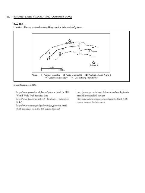
GEOGRAPHICAL INFORMATION SYSTEMS 251 Geographical Information Systems While not exactly a simulation, the computerbased Geographical Information Systems are becoming increasingly used in educational research, for example in discussing patterns of student recruitment and school choice. Educational policy frequently has geographical implications and dimensions, e.g. catchment areas, school closures, open enrolment and school choice, the distribution of resources and financial expenditure, the distribution of assessment scores and examination results. Geographical Information Systems is a computer-based system for capturing, storing, validating, analysing and displaying spatial data, both large scale and small scale, integrating several types of data from different sources (Worrall 1990; Parsons et al. 1996; Gorard et al. 2002). This is useful for teasing out the implications and outcomes of policy initiatives, for example: ‘What is the effect of parental choice on school catchments’; ‘What is the spread of examination scores in a particular region’; ‘How effective is the provision of secondary schools for a given population’; ‘How can a transport system be made more effective for taking students to and from school’; ‘What is the evidence for the creation of ‘magnet’ and ‘sink’ schools in a particular city’. Examples of the data presented here are given in Boxes 10.2 and 10.3. Clearly the political sensitivity and significance of these kinds of data are immense, indicating how research can inform policy-making and its effects very directly. Parsons et al. (1996)provide a straightforward, fully referenced introduction to this field of research in education, and they present case studies of catchment areas and examination performance, the redistribution of school catchments, and the pattern of movements in catchments. Readers wishing to research Geographical Information Systems (GIS) on the Internet can access several sites by keying in ‘education research Geographical Information Systems’ on a search engine for the Internet or by visiting the following web sites: Chapter 10 Box 10.2 Geographical Information Systems in secondary schools School A Scale 0 300m School B Notes Pupils at school A Pupils at schools A and B Pupils at school B Catchment boundary Source: Parsons et al.1996
252 INTERNET-BASED RESEARCH AND COMPUTER USAGE Box 10.3 Location of home postcodes using Geographical Information Systems School A Scale 0 300m School B Notes Pupils at school A Pupils at school B Pupils at schools A and B Catchment boundary Line defining 100m buffer Source: Parsons et al.1996 http://www.geo.ed.ac.uk/home/giswww.html (a GIS World Wide Web resource list) http://www.tec.army.mil/gis/ (includes Education links) http://www.census.gov/geo/www/gis gateway.html (GIS resources from the US census bureau) http://www.geo.uni-bonn.de/members/haack/gisinfo. html (European link server) http://unr.edu/homepage/daved/gislinks.html (GIS resources over the Internet)
- Page 220 and 221: DOCUMENTARY RESEARCH 201 Documentar
- Page 222 and 223: DOCUMENTARY RESEARCH 203 What are
- Page 224 and 225: 9 Surveys, longitudinal, cross-sect
- Page 226 and 227: SOME PRELIMINARY CONSIDERATIONS 207
- Page 228 and 229: PLANNING A SURVEY 209 structured or
- Page 230 and 231: LONGITUDINAL, CROSS-SECTIONAL AND T
- Page 232 and 233: LONGITUDINAL, CROSS-SECTIONAL AND T
- Page 234 and 235: STRENGTHS AND WEAKNESSES OF LONGITU
- Page 236 and 237: STRENGTHS AND WEAKNESSES OF LONGITU
- Page 238 and 239: POSTAL, INTERVIEW AND TELEPHONE SUR
- Page 240 and 241: POSTAL, INTERVIEW AND TELEPHONE SUR
- Page 242 and 243: POSTAL, INTERVIEW AND TELEPHONE SUR
- Page 244 and 245: EVENT HISTORY ANALYSIS 225 may be p
- Page 246 and 247: INTERNET-BASED SURVEYS 227 packages
- Page 248 and 249: INTERNET-BASED SURVEYS 229 instruc
- Page 250 and 251: INTERNET-BASED SURVEYS 231 Box 10.1
- Page 252 and 253: INTERNET-BASED SURVEYS 233 Box 10.1
- Page 254 and 255: INTERNET-BASED SURVEYS 235 Box 10.1
- Page 256 and 257: INTERNET-BASED SURVEYS 237 Witte et
- Page 258 and 259: INTERNET-BASED EXPERIMENTS 239 requ
- Page 260 and 261: INTERNET-BASED INTERVIEWS 241 ‘ne
- Page 262 and 263: SEARCHING FOR RESEARCH MATERIALS ON
- Page 264 and 265: COMPUTER SIMULATIONS 245 autho
- Page 266 and 267: COMPUTER SIMULATIONS 247 computer s
- Page 268 and 269: COMPUTER SIMULATIONS 249 On the oth
- Page 272 and 273: 11 Case studies What is a case stud
- Page 274 and 275: WHAT IS A CASE STUDY 255 (providing
- Page 276 and 277: WHAT IS A CASE STUDY 257 argue that
- Page 278 and 279: EXAMPLES OF KINDS OF CASE STUDY 259
- Page 280 and 281: PLANNING A CASE STUDY 261 accounts
- Page 282 and 283: CONCLUSION 263 In the narrativ
- Page 284 and 285: CO-RELATIONAL AND CRITERION GROUPS
- Page 286 and 287: CHARACTERISTICS OF EX POST FACTO RE
- Page 288 and 289: DESIGNING AN EX POST FACTO INVESTIG
- Page 290 and 291: PROCEDURES IN EX POST FACTO RESEARC
- Page 292 and 293: INTRODUCTION 273 Box 13.1 Independe
- Page 294 and 295: TRUE EXPERIMENTAL DESIGNS 275 motor
- Page 296 and 297: TRUE EXPERIMENTAL DESIGNS 277 2 Sub
- Page 298 and 299: TRUE EXPERIMENTAL DESIGNS 279 textb
- Page 300 and 301: TRUE EXPERIMENTAL DESIGNS 281 Facto
- Page 302 and 303: A QUASI-EXPERIMENTAL DESIGN: THE NO
- Page 304 and 305: PROCEDURES IN CONDUCTING EXPERIMENT
- Page 306 and 307: EXAMPLES FROM EDUCATIONAL RESEARCH
- Page 308 and 309: EVIDENCE-BASED EDUCATIONAL RESEARCH
- Page 310 and 311: EVIDENCE-BASED EDUCATIONAL RESEARCH
- Page 312 and 313: EVIDENCE-BASED EDUCATIONAL RESEARCH
- Page 314 and 315: EVIDENCE-BASED EDUCATIONAL RESEARCH
- Page 316 and 317: 14 Action research Introduction Act
- Page 318 and 319: PRINCIPLES AND CHARACTERISTICS OF A
252 INTERNET-BASED <strong>RESEARCH</strong> AND COMPUTER USAGE<br />
Box 10.3<br />
Location of home postcodes using Geographical Information Systems<br />
School A<br />
Scale<br />
0 300m<br />
School B<br />
Notes<br />
Pupils at school A Pupils at school B Pupils at schools A and B<br />
Catchment boundary Line defining 100m buffer<br />
Source: Parsons et al.1996<br />
http://www.geo.ed.ac.uk/home/giswww.html (a GIS<br />
World Wide Web resource list)<br />
http://www.tec.army.mil/gis/ (includes Education<br />
links)<br />
http://www.census.gov/geo/www/gis gateway.html<br />
(GIS resources from the US census bureau)<br />
http://www.geo.uni-bonn.de/members/haack/gisinfo.<br />
html (European link server)<br />
http://unr.edu/homepage/daved/gislinks.html (GIS<br />
resources over the Internet)


