

Metropolitan Melbourne Investigation Discussion Paper - Victorian ...
Metropolitan Melbourne Investigation Discussion Paper - Victorian ...
Metropolitan Melbourne Investigation Discussion Paper - Victorian ...

Create successful ePaper yourself
Turn your PDF publications into a flip-book with our unique Google optimized e-Paper software.
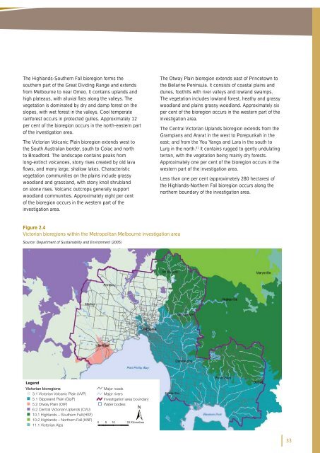
The Highlands-Southern Fall bioregion forms the<br />
southern part of the Great Dividing Range and extends<br />
from <strong>Melbourne</strong> to near Omeo. It contains uplands and<br />
high plateaus, with alluvial fl ats along the valleys. The<br />
vegetation is dominated by dry and damp forest on the<br />
slopes, with wet forest in the valleys. Cool temperate<br />
rainforest occurs in protected gullies. Approximately 12<br />
per cent of the bioregion occurs in the north-eastern part<br />
of the investigation area.<br />
The <strong>Victorian</strong> Volcanic Plain bioregion extends west to<br />
the South Australian border, south to Colac and north<br />
to Broadford. The landscape contains peaks from<br />
long-extinct volcanoes, stony rises created by old lava<br />
fl ows, and many large, shallow lakes. Characteristic<br />
vegetation communities on the plains include grassy<br />
woodland and grassland, with stony knoll shrubland<br />
on stone rises. Volcanic outcrops generally support<br />
woodland communities. Approximately eight per cent<br />
of the bioregion occurs in the western part of the<br />
investigation area.<br />
The Otway Plain bioregion extends east of Princetown to<br />
the Bellarine Peninsula. It consists of coastal plains and<br />
dunes, foothills with river valleys and lowland swamps.<br />
The vegetation includes lowland forest, heathy and grassy<br />
woodland and plains grassy woodland. Approximately six<br />
per cent of the bioregion occurs in the western part of the<br />
investigation area.<br />
The Central <strong>Victorian</strong> Uplands bioregion extends from the<br />
Grampians and Ararat in the west to Porepunkah in the<br />
east; and from the You Yangs and Lara in the south to<br />
Lurg in the north. 51 It contains rugged to gently undulating<br />
terrain, with the vegetation being mainly dry forests.<br />
Approximately one per cent of the bioregion occurs in the<br />
western part of the investigation area.<br />
Less than one per cent (approximately 280 hectares) of<br />
the Highlands-Northern Fall bioregion occurs along the<br />
northern boundary of the investigation area.<br />
Figure 2.4<br />
<strong>Victorian</strong> bioregions within the <strong>Metropolitan</strong> <strong>Melbourne</strong> investigation area<br />
Source: Department of Sustainability and Environment (2005)<br />
Legend<br />
<strong>Victorian</strong> bioregions<br />
Major<br />
3.1 <strong>Victorian</strong> Volcanic Plain (VVP)<br />
5.1 Gippsland Plain (GipP)<br />
5.2 Otway Plain (OtP)<br />
6.2 Central <strong>Victorian</strong> Uplands (CVU)<br />
10.1 Highlands – Southern Fall (HSF)<br />
10.2 Highlands – Northern Fall (HNF)<br />
11.1 <strong>Victorian</strong> Alps<br />
<br />
roads<br />
Major rivers<br />
<strong>Investigation</strong> area boundary<br />
Water bodies<br />
0 5 10 20 Kilometres<br />
33


