Slope stability analysis in hard rocks and prediction of ... - Paas.com.pk
Slope stability analysis in hard rocks and prediction of ... - Paas.com.pk
Slope stability analysis in hard rocks and prediction of ... - Paas.com.pk

You also want an ePaper? Increase the reach of your titles
YUMPU automatically turns print PDFs into web optimized ePapers that Google loves.
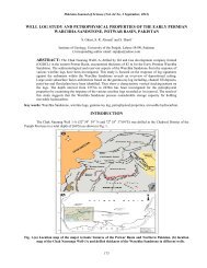
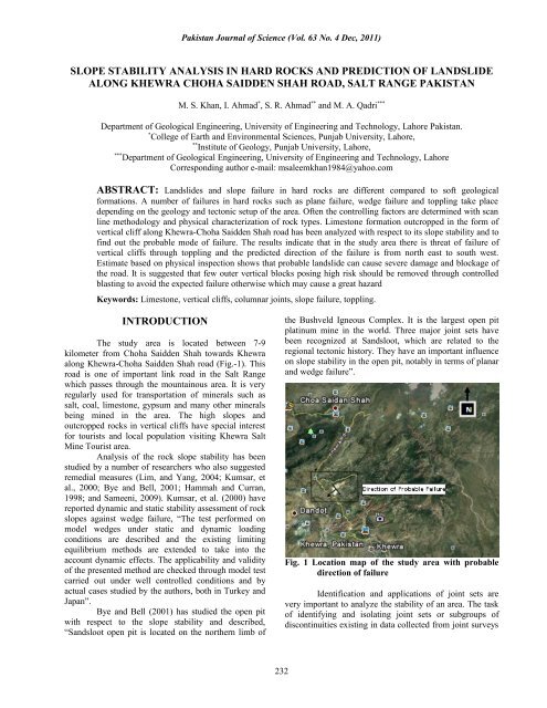
Pakistan Journal <strong>of</strong> Science (Vol. 63 No. 4 Dec, 2011)<br />
SLOPE STABILITY ANALYSIS IN HARD ROCKS AND PREDICTION OF LANDSLIDE<br />
ALONG KHEWRA CHOHA SAIDDEN SHAH ROAD, SALT RANGE PAKISTAN<br />
M. S. Khan, I. Ahmad * , S. R. Ahmad ** <strong>and</strong> M. A. Qadri ***<br />
Department <strong>of</strong> Geological Eng<strong>in</strong>eer<strong>in</strong>g, University <strong>of</strong> Eng<strong>in</strong>eer<strong>in</strong>g <strong>and</strong> Technology, Lahore Pakistan.<br />
*<br />
College <strong>of</strong> Earth <strong>and</strong> Environmental Sciences, Punjab University, Lahore,<br />
**<br />
Institute <strong>of</strong> Geology, Punjab University, Lahore,<br />
***<br />
Department <strong>of</strong> Geological Eng<strong>in</strong>eer<strong>in</strong>g, University <strong>of</strong> Eng<strong>in</strong>eer<strong>in</strong>g <strong>and</strong> Technology, Lahore<br />
Correspond<strong>in</strong>g author e-mail: msaleemkhan1984@yahoo.<strong>com</strong><br />
ABSTRACT: L<strong>and</strong>slides <strong>and</strong> slope failure <strong>in</strong> <strong>hard</strong> <strong>rocks</strong> are different <strong>com</strong>pared to s<strong>of</strong>t geological<br />
formations. A number <strong>of</strong> failures <strong>in</strong> <strong>hard</strong> <strong>rocks</strong> such as plane failure, wedge failure <strong>and</strong> toppl<strong>in</strong>g take place<br />
depend<strong>in</strong>g on the geology <strong>and</strong> tectonic setup <strong>of</strong> the area. Often the controll<strong>in</strong>g factors are determ<strong>in</strong>ed with scan<br />
l<strong>in</strong>e methodology <strong>and</strong> physical characterization <strong>of</strong> rock types. Limestone formation outcropped <strong>in</strong> the form <strong>of</strong><br />
vertical cliff along Khewra-Choha Saidden Shah road has been analyzed with respect to its slope <strong>stability</strong> <strong>and</strong> to<br />
f<strong>in</strong>d out the probable mode <strong>of</strong> failure. The results <strong>in</strong>dicate that <strong>in</strong> the study area there is threat <strong>of</strong> failure <strong>of</strong><br />
vertical cliffs through toppl<strong>in</strong>g <strong>and</strong> the predicted direction <strong>of</strong> the failure is from north east to south west.<br />
Estimate based on physical <strong>in</strong>spection shows that probable l<strong>and</strong>slide can cause severe damage <strong>and</strong> blockage <strong>of</strong><br />
the road. It is suggested that few outer vertical blocks pos<strong>in</strong>g high risk should be removed through controlled<br />
blast<strong>in</strong>g to avoid the expected failure otherwise which may cause a great hazard<br />
Keywords: Limestone, vertical cliffs, columnar jo<strong>in</strong>ts, slope failure, toppl<strong>in</strong>g.<br />
INTRODUCTION<br />
The study area is located between 7-9<br />
kilometer from Choha Saidden Shah towards Khewra<br />
along Khewra-Choha Saidden Shah road (Fig.-1). This<br />
road is one <strong>of</strong> important l<strong>in</strong>k road <strong>in</strong> the Salt Range<br />
which passes through the mounta<strong>in</strong>ous area. It is very<br />
regularly used for transportation <strong>of</strong> m<strong>in</strong>erals such as<br />
salt, coal, limestone, gypsum <strong>and</strong> many other m<strong>in</strong>erals<br />
be<strong>in</strong>g m<strong>in</strong>ed <strong>in</strong> the area. The high slopes <strong>and</strong><br />
outcropped <strong>rocks</strong> <strong>in</strong> vertical cliffs have special <strong>in</strong>terest<br />
for tourists <strong>and</strong> local population visit<strong>in</strong>g Khewra Salt<br />
M<strong>in</strong>e Tourist area.<br />
Analysis <strong>of</strong> the rock slope <strong>stability</strong> has been<br />
studied by a number <strong>of</strong> researchers who also suggested<br />
remedial measures (Lim, <strong>and</strong> Yang, 2004; Kumsar, et<br />
al., 2000; Bye <strong>and</strong> Bell, 2001; Hammah <strong>and</strong> Curran,<br />
1998; <strong>and</strong> Sameeni, 2009). Kumsar, et al. (2000) have<br />
reported dynamic <strong>and</strong> static <strong>stability</strong> assessment <strong>of</strong> rock<br />
slopes aga<strong>in</strong>st wedge failure, “The test performed on<br />
model wedges under static <strong>and</strong> dynamic load<strong>in</strong>g<br />
conditions are described <strong>and</strong> the exist<strong>in</strong>g limit<strong>in</strong>g<br />
equilibrium methods are extended to take <strong>in</strong>to the<br />
account dynamic effects. The applicability <strong>and</strong> validity<br />
<strong>of</strong> the presented method are checked through model test<br />
carried out under well controlled conditions <strong>and</strong> by<br />
actual cases studied by the authors, both <strong>in</strong> Turkey <strong>and</strong><br />
Japan”.<br />
Bye <strong>and</strong> Bell (2001) has studied the open pit<br />
with respect to the slope <strong>stability</strong> <strong>and</strong> described,<br />
“S<strong>and</strong>sloot open pit is located on the northern limb <strong>of</strong><br />
the Bushveld Igneous Complex. It is the largest open pit<br />
plat<strong>in</strong>um m<strong>in</strong>e <strong>in</strong> the world. Three major jo<strong>in</strong>t sets have<br />
been recognized at S<strong>and</strong>sloot, which are related to the<br />
regional tectonic history. They have an important <strong>in</strong>fluence<br />
on slope <strong>stability</strong> <strong>in</strong> the open pit, notably <strong>in</strong> terms <strong>of</strong> planar<br />
<strong>and</strong> wedge failure”.<br />
Fig. 1 Location map <strong>of</strong> the study area with probable<br />
direction <strong>of</strong> failure<br />
Identification <strong>and</strong> applications <strong>of</strong> jo<strong>in</strong>t sets are<br />
very important to analyze the <strong>stability</strong> <strong>of</strong> an area. The task<br />
<strong>of</strong> identify<strong>in</strong>g <strong>and</strong> isolat<strong>in</strong>g jo<strong>in</strong>t sets or subgroups <strong>of</strong><br />
discont<strong>in</strong>uities exist<strong>in</strong>g <strong>in</strong> data collected from jo<strong>in</strong>t surveys<br />
232
Pakistan Journal <strong>of</strong> Science (Vol. 63 No. 4 Dec, 2011)<br />
is not a trivial issue <strong>and</strong> is fundamental to rock<br />
eng<strong>in</strong>eer<strong>in</strong>g design (Hammah <strong>and</strong> Curran, 1998).<br />
In addition to the identification <strong>of</strong> jo<strong>in</strong>t sets<br />
<strong>and</strong> their orientation, the physical characterization <strong>of</strong><br />
the outcropped rock <strong>in</strong> the slopes is very important. It<br />
also <strong>in</strong>cludes identification <strong>of</strong> the rock type, its<br />
weather<strong>in</strong>g grade, roughness <strong>of</strong> the jo<strong>in</strong>ts <strong>and</strong> water<br />
condition along the jo<strong>in</strong>t planes. This study has been<br />
carried out to analyze the slopes <strong>and</strong> to predict the<br />
possible failure mode <strong>in</strong> limestone formation mak<strong>in</strong>g<br />
vertical cliffs which are located along Khewra-Choha<br />
Saidden Shah road <strong>in</strong> tectonically fragile zone <strong>of</strong> Salt<br />
Range, Pakistan.<br />
MATERIALS AND METHODS<br />
Field geological survey was carried out to<br />
collect data by adopt<strong>in</strong>g scan l<strong>in</strong>e methodology along<br />
the critical section <strong>of</strong> Khewra-Choha Saidden Shah<br />
road. The survey <strong>in</strong>dicated that two geological<br />
formations, Tobra <strong>and</strong> Sakesar Limestone are exposed<br />
<strong>in</strong> the study area The Sakesar Limestone forms vertical<br />
cliffs <strong>and</strong> susceptible to slope <strong>stability</strong> problem which<br />
can be further classified <strong>in</strong>to, massive limestone,<br />
nodular limestone <strong>and</strong> argillaceous limestone.<br />
Measurements <strong>of</strong> dip, strike <strong>and</strong> dip direction<br />
(cont<strong>in</strong>uous sampl<strong>in</strong>g).was recorded at every<br />
discont<strong>in</strong>uity. To analyze <strong>and</strong> determ<strong>in</strong>e the possible<br />
failure mode, the DIPS S<strong>of</strong>tware (2005) was used.<br />
Fig. 2. A view <strong>of</strong> possible l<strong>and</strong>slide section with<br />
predicted toppl<strong>in</strong>g block.<br />
RESULTS AND DISCUSSION<br />
The geology <strong>of</strong> the study area is<br />
predom<strong>in</strong>antly <strong>com</strong>posed <strong>of</strong> limestone belong<strong>in</strong>g to<br />
Sakesar Limestone Formation <strong>of</strong> Eocene age. Shah<br />
(2009) reported the Sakesar Limestone as, “the unit<br />
consists dom<strong>in</strong>antly <strong>of</strong> limestone with subord<strong>in</strong>ate marl.<br />
The limestone through out its extent is cream coloured<br />
to light grey, nodular usually massive with considerable<br />
development <strong>of</strong> the chert nodules <strong>in</strong> upper part. The<br />
formation is widely distributed <strong>in</strong> Salt Range <strong>and</strong> the<br />
Surgher Range. In the Salt Range its thickness varies<br />
between 70 m <strong>and</strong> 150 m.”<br />
Generally there are 5-6 feet thick alternate<br />
beds <strong>of</strong> nodular <strong>and</strong> massive limestone. The top most<br />
massive bed is more than 10 feet thick. The bedd<strong>in</strong>g<br />
planes conta<strong>in</strong> fill<strong>in</strong>g <strong>of</strong> argillaceous material which is<br />
weathered <strong>and</strong> eroded. The formation is mak<strong>in</strong>g vertical<br />
cliffs <strong>of</strong> more than 80 feet high nearby road side <strong>in</strong> the<br />
study area. Open vertical columnar jo<strong>in</strong>ts are very<br />
<strong>com</strong>mon <strong>in</strong> Sakesar Limestone <strong>and</strong> at places these<br />
jo<strong>in</strong>ts are up to 2 feet wide <strong>in</strong> upper horizon (Fig.-2).<br />
Fig. 3. Contour plot <strong>of</strong> data <strong>in</strong>dicat<strong>in</strong>g the concentration<br />
areas.<br />
The exercise performed on the basis <strong>of</strong> 51<br />
discont<strong>in</strong>uities read<strong>in</strong>gs <strong>of</strong> jo<strong>in</strong>ts <strong>and</strong> bedd<strong>in</strong>g planes from<br />
the study area are utilized for <strong>analysis</strong> <strong>of</strong> slope <strong>stability</strong>.<br />
The field data is used to develop contour concentration<br />
(Fig.-3). On the basis <strong>of</strong> contour concentration weighted<br />
average planes are generated, which are given <strong>in</strong> the form<br />
<strong>of</strong> rosette plot (Fig.-4). There are 4 numbers <strong>of</strong> major jo<strong>in</strong>t<br />
sets present which contribute towards probable slope<br />
failure <strong>in</strong> various <strong>rocks</strong> outcropped <strong>in</strong> the area.<br />
233
Pakistan Journal <strong>of</strong> Science (Vol. 63 No. 4 Dec, 2011)<br />
The <strong>analysis</strong> made with s<strong>of</strong>tware (Dips, 2005) clearly<br />
<strong>in</strong>dicates toppl<strong>in</strong>g failure <strong>in</strong> the outcropped formation<br />
which is given <strong>in</strong> Figure-5. The orientation <strong>of</strong> the<br />
predicted l<strong>and</strong>slide failure is from north east to south west.<br />
Hence the high risks blocks (Fig.-2) are capable to block<br />
<strong>and</strong> severely damage the road.<br />
Fig. 4 Rosette plot <strong>of</strong> data high light<strong>in</strong>g the orientation <strong>of</strong> toppl<strong>in</strong>g region<br />
Fig. 5. Estimate <strong>of</strong> the toppl<strong>in</strong>g risk region with probable failure plans.<br />
Conclusion: Four jo<strong>in</strong>t planes have been identified <strong>in</strong><br />
the study area which is responsible for slope failure.<br />
The stereographic <strong>analysis</strong> has <strong>in</strong>dicated that failure <strong>in</strong><br />
the vertical cliff through toppl<strong>in</strong>g is expected. It is<br />
suggested to immediately adapt precautionary measures<br />
such as removal <strong>of</strong> toppl<strong>in</strong>g region under high risk through<br />
control blast<strong>in</strong>g to avoid possible hazard.<br />
Acknowledgement: The facilities for field visits <strong>and</strong><br />
test<strong>in</strong>g were provided by the University <strong>of</strong> Eng<strong>in</strong>eer<strong>in</strong>g <strong>and</strong><br />
Technology, Lahore which is greatly acknowledged.<br />
234
Pakistan Journal <strong>of</strong> Science (Vol. 63 No. 4 Dec, 2011)<br />
REFERENCES<br />
Bye, A. R. <strong>and</strong> F. G. Bell, Stability assessment <strong>and</strong><br />
slope design at S<strong>and</strong>sloot open pit, South<br />
Africa. International Journal <strong>of</strong> Rock<br />
Mechanics <strong>and</strong> M<strong>in</strong><strong>in</strong>g Sciences 38, 449–466<br />
(2001)<br />
Hammah, R. E. <strong>and</strong> F. G. Curran, J. H. Fuzzy Cluster<br />
Alogrithm for the Automatic Identification <strong>of</strong><br />
jo<strong>in</strong>t sets. Int. J. Rock Mech. M<strong>in</strong>. Sci. 35,<br />
(7):889-905 (1998).<br />
Kumsar, H., O. E. Aydan, <strong>and</strong> R., Ulusay. Dynamic <strong>and</strong><br />
Static Stability Assessment <strong>of</strong> rock slopes<br />
aga<strong>in</strong>st wedge failures. Rock Mech. Rock Engg.<br />
33 (1):31-51 (2000).<br />
Lim, S.S. <strong>and</strong> H.S. Yang. An <strong>analysis</strong> <strong>of</strong> plane failure <strong>of</strong><br />
rock slopes by quantified stereographic projection.<br />
Int. Jou. <strong>of</strong> Rock Mech. <strong>and</strong> M<strong>in</strong> Sci. 41 (3): 3A<br />
05 (2004):<br />
Sameeni, S.J,. The Salt Range: Pakistan’s unique field<br />
museum <strong>of</strong> geology <strong>and</strong> paleontology. Carnet de<br />
Geology/Notebook on Geology- Book 2009/03<br />
(CG2009_03), chapter 6 (2009).<br />
Shah, S.I. Stratigraphy <strong>of</strong> Pakistan (Memoirs <strong>of</strong> the<br />
Geological Survey <strong>of</strong> Pakistan). Published by<br />
Geological Survey <strong>of</strong> Pakistan, Vol. 22, (2009).<br />
235