Smithtown Groundwater Contamination
Smithtown Groundwater Contamination
Smithtown Groundwater Contamination

Create successful ePaper yourself
Turn your PDF publications into a flip-book with our unique Google optimized e-Paper software.
<strong>Smithtown</strong> <strong>Groundwater</strong> <strong>Contamination</strong><br />
<strong>Smithtown</strong>, New York<br />
EPA Facility ID: NY0002318889<br />
Basin: Long Island Sound<br />
HUC: 02030201<br />
<strong>Smithtown</strong> <strong>Groundwater</strong> <strong>Contamination</strong> 21<br />
Executive Summary<br />
The <strong>Smithtown</strong> <strong>Groundwater</strong> <strong>Contamination</strong> area is approximately 3 km (2 mi) south of <strong>Smithtown</strong><br />
Bay and Long Island Sound in <strong>Smithtown</strong>, New York. Field investigations have identified an area of<br />
VOC-contaminated groundwater of approximately 1,036 hectares (2,560 acres). The primary VOC<br />
of concern is tetrachloroethylene. The presence of VOCs at the site may increase the potential for<br />
other, more persistent contaminants to migrate through the groundwater to NOAA trust resources.<br />
Further analysis for other contaminants has not been conducted, and no other analytes have<br />
been measured in the groundwater. Several commercial and industrial facilities in the area have<br />
been investigated to identify the source of the contamination, but sources of contamination have<br />
not been identified. The Nissequogue River and Stony Brook Harbor estuaries within Long Island<br />
Sound, which are the NOAA habitats of concern, contain NOAA trust resources, including marine<br />
and anadromous fish species, that use the waters for spawning, rearing, and adult residence.<br />
Site Background<br />
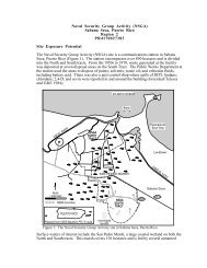
The <strong>Smithtown</strong> <strong>Groundwater</strong> <strong>Contamination</strong> area is approximately 3 km (2 mi) south of <strong>Smithtown</strong><br />
Bay and Long Island Sound in <strong>Smithtown</strong>, Suffolk County, New York. The groundwater contamination<br />
area is approximately 1,036 ha (2,560 acres), bounded to the north by Stony Brook Harbor and<br />
to the west by the Nissequogue River (Figure 1) (CDM 1999b).<br />
Volatile organic compounds (VOCs), primarily tetrachloroethylene (also known as perchloroethylene,<br />
or PCE), were first detected in groundwater at the site in 1997 (Weston 1998). The Suffolk<br />
County Department of Health Services has investigated 11 potential sources of the contaminated<br />
groundwater plume, including current and former commercial and industrial facilities located east<br />
of the contamination. The sources of contamination have not been fully identified (CDM 1999b).<br />
The U.S. Environmental Protection Agency (USEPA) signed an Action Memorandum in July 1998<br />
authorizing removal action activities to be conducted in the groundwater contamination area. The<br />
USEPA proposed that the <strong>Smithtown</strong> <strong>Groundwater</strong> <strong>Contamination</strong> area be placed on the National<br />
Priorities List in January 1999 (CDM 1999b).<br />
The shallow, unconfined water table aquifer over most of Long Island is within the Upper Glacial<br />
aquifer system (CDM 1999a). Regional groundwater flows north toward <strong>Smithtown</strong> Bay and Long<br />
Island Sound, although the Nissequogue River and Stony Brook Harbor induce flow to the west<br />
and east, respectively (CDM 1999b). The minimum depth to the water table is approximately 9 m<br />
(30 ft) below ground surface (CDM 1999a).
22 EPA Region 2<br />
Long Island Sound<br />
<strong>Smithtown</strong><br />
Bay<br />
25A<br />
Nissequogue River<br />
Nissequogue<br />
Stony<br />
Brook<br />
Harbor<br />
Head of<br />
Harbor<br />
Approximate location<br />
of <strong>Smithtown</strong> <strong>Groundwater</strong><br />
<strong>Contamination</strong> area<br />
11<br />
<strong>Groundwater</strong><br />
flow direction<br />
Hamlet of<br />
St. James<br />
<strong>Smithtown</strong><br />
25<br />
25<br />
VT<br />
NH<br />
ME<br />
N<br />
0<br />
kilometers<br />
1 2<br />
miles<br />
0 0.5 1<br />
NY<br />
MA<br />
CT<br />
R I<br />
NJ<br />
PA<br />
Prepared from USGS 1:100,000-scale Long Island West, NY-NJ-CT, 1984<br />
Figure 1. Approximate location of <strong>Smithtown</strong> <strong>Groundwater</strong> <strong>Contamination</strong> area<br />
in <strong>Smithtown</strong>, New York.<br />
NOAA Trust Resources<br />
The NOAA habitats of concern are the Nissequogue River and Stony Brook Harbor, which are estuaries<br />
within Long Island Sound. Many fish and invertebrates, including NOAA trust resources, use<br />
these estuaries for spawning, rearing, and adult habitat (Table 1).
<strong>Smithtown</strong> <strong>Groundwater</strong> <strong>Contamination</strong> 23<br />
Table 1. Fish and invertebrate species commonly found in Long Island Sound estuaries<br />
(Stone et al. 1994).<br />
Species Habitat Use Fisheries<br />
Common Name<br />
Scientific Name<br />
ANADROMOUS/CATADROMOUS FISH<br />
Spawning<br />
Ground<br />
Nursery<br />
Area<br />
Alewife Alosa pseudoharengus <br />
American shad Alosa sapidissima <br />
Blueback herring Alosa aestivalis <br />
Rainbow smelt Osmerus mordax <br />
Adult<br />
Forage Comm. Recr.<br />
Striped bass Morone saxatilis <br />
White perch Morone americana <br />
MARINE/ESTUARINE FISH<br />
American sand lance Ammodytes americanus <br />
Atlantic herring Clupea harengus <br />
Atlantic mackerel Scomber scombrus <br />
Atlantic menhaden Brevoortia tyrannus <br />
Atlantic tomcod Microgadus tomcod <br />
Bay anchovy Anchoa mitchilli <br />
Black sea bass Centropristis striata <br />
Bluefish Pomatomus saltatrix <br />
Butterfish Peprilus triacanthus <br />
Cunner Tautogolabrus adspersus <br />
Gobies Gobiosoma spp. <br />
Hogchoker Trinectes maculatus <br />
Killifish Fundulus spp. <br />
Northern pipefish Syngnathus fuscus <br />
Northern searobin Prionotus carolinus <br />
Oyster toadfish Opsanus tau <br />
Pollock Pollachius virens <br />
Red hake Urophycis chuss <br />
Scup Stenotomus chrysops <br />
Sheepshead minnow Cyprinodon variegatus <br />
Silversides Menidia spp. <br />
Skates Raja spp. <br />
Tautog Tautoga onitis <br />
Weakfish Cynoscion regalis <br />
Windowpane flounder Scophthalmus aquosus <br />
Winter flounder Pleuronectes americanus <br />
INVERTEBRATES<br />
American lobster Homarus americanus <br />
Blue crab Callinectes sapidus <br />
Blue mussel Mytilus edulis <br />
Eastern oyster Crassostrea virginica <br />
Grass shrimp Palaemonetes pugio <br />
Northern quahog Mercenaria spp. <br />
Sevenspine bay shrimp Crangon septemspinosa <br />
Softshell clam Mya arenaria
24 EPA Region 2<br />
Site-Related <strong>Contamination</strong><br />
The sources of the contaminated groundwater plume have not been fully identified (CDM 1999b).<br />
The presence of VOCs at the site may increase the potential for other, more persistent contaminants<br />
to migrate through the groundwater to NOAA trust resources. NOAA is concerned about<br />
contaminants more persistent than VOCs, but the groundwater has yet to be analyzed for contaminants<br />
other than VOCs. Therefore, data on the presence of other, more persistent contaminants<br />
were not available at the time of this report.<br />
References<br />
CDM Federal Programs Corporation (CDM). 1999a. Final quality assurance project plan, Phase I,<br />
<strong>Smithtown</strong> groundwater contamination site, <strong>Smithtown</strong>, New York. New York, NY: U.S. Environmental<br />
Protection Agency.<br />
CDM Federal Programs Corporation (CDM). 1999b. Final work plan, Volume I, <strong>Smithtown</strong> groundwater<br />
contamination site, Phase I remedial investigation, <strong>Smithtown</strong>, New York. New York, NY: U.S.<br />
Environmental Protection Agency.<br />
Roy F. Weston Inc. (Weston). 1998. Hazard ranking system documentation package, <strong>Smithtown</strong><br />
ground water contamination, <strong>Smithtown</strong>, Suffolk County, New York. New York, NY: U.S. Environmental<br />
Protection Agency, Region II Superfund Technical Assessment and Response Team.<br />
Stone, S.L., T.A. Lowery, J.D. Field, C.D. Williams, D.M. Nelson, S.H. Jury, M.E. Monaco, and L. Andreasen.<br />
1994. Distribution and abundance of fishes and invertebrates in Mid-Atlantic estuaries. Silver<br />
Spring, MD: NOAA/NOS Strategic Environmental Assessments Division.