Table of Contents - HUNAGI
Table of Contents - HUNAGI
Table of Contents - HUNAGI

You also want an ePaper? Increase the reach of your titles
YUMPU automatically turns print PDFs into web optimized ePapers that Google loves.
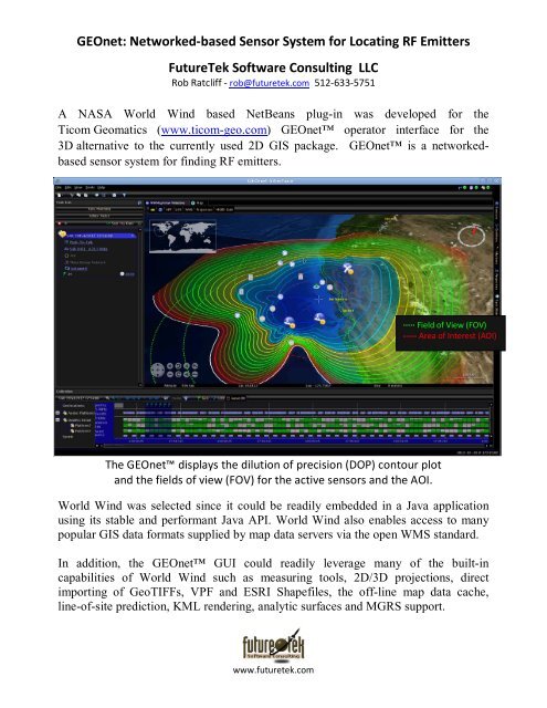
GEOnet: Networked-based Sensor System for Locating RF Emitters<br />
FutureTek S<strong>of</strong>tware Consulting LLC<br />
Rob Ratcliff - rob@futuretek.com 512-633-5751<br />
A NASA World Wind based NetBeans plug-in was developed for the<br />
Ticom Geomatics (www.ticom-geo.com) GEOnet operator interface for the<br />
3D alternative to the currently used 2D GIS package. GEOnet is a networkedbased<br />
sensor system for finding RF emitters.<br />
∙∙∙∙∙ Field <strong>of</strong> View (FOV)<br />
----- Area <strong>of</strong> Interest (AOI)<br />
The GEOnet displays the dilution <strong>of</strong> precision (DOP) contour plot<br />
and the fields <strong>of</strong> view (FOV) for the active sensors and the AOI.<br />
World Wind was selected since it could be readily embedded in a Java application<br />
using its stable and performant Java API. World Wind also enables access to many<br />
popular GIS data formats supplied by map data servers via the open WMS standard.<br />
In addition, the GEOnet GUI could readily leverage many <strong>of</strong> the built-in<br />
capabilities <strong>of</strong> World Wind such as measuring tools, 2D/3D projections, direct<br />
importing <strong>of</strong> GeoTIFFs, VPF and ESRI Shapefiles, the <strong>of</strong>f-line map data cache,<br />
line-<strong>of</strong>-site prediction, KML rendering, analytic surfaces and MGRS support.<br />
www.futuretek.com