Lecture: Introduction to Seismology and Ground Motion Parameters
Lecture: Introduction to Seismology and Ground Motion Parameters
Lecture: Introduction to Seismology and Ground Motion Parameters

Create successful ePaper yourself
Turn your PDF publications into a flip-book with our unique Google optimized e-Paper software.
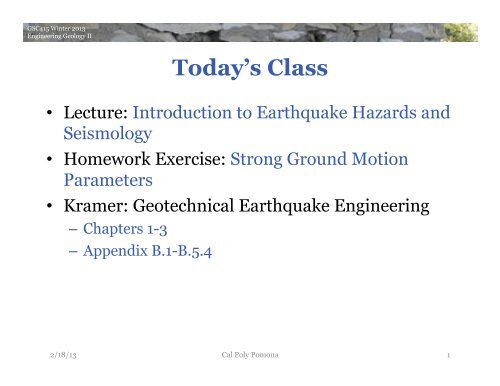
GSC415 Winter 2013<br />
Engineering Geology II<br />
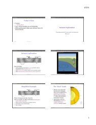
Today’s Class<br />
• <strong>Lecture</strong>: <strong>Introduction</strong> <strong>to</strong> Earthquake Hazards <strong>and</strong><br />
<strong>Seismology</strong><br />
• Homework Exercise: Strong <strong>Ground</strong> <strong>Motion</strong><br />
<strong>Parameters</strong><br />
• Kramer: Geotechnical Earthquake Engineering<br />
– Chapters 1-3<br />
– Appendix B.1-B.5.4<br />
2/18/13 Cal Poly Pomona<br />
1
GSC415 Winter 2013<br />
Engineering Geology II<br />
<strong>Introduction</strong> <strong>to</strong> Earthquake<br />
Hazards <strong>and</strong> <strong>Seismology</strong>
local agency (city or county); show location of fault investigation trenches; 50-foot setbacks perpendicular from fault<br />
plane <strong>and</strong> proposed building footprints.<br />
9. Geologic Hazard Zones (Liquefaction & L<strong>and</strong>slides): (If applicable) Show proposed structures in<br />
relation <strong>to</strong> CGS official map showing zones of required investigation for liquefaction <strong>and</strong> l<strong>and</strong>slide, <strong>and</strong>/or any pertinent<br />
GSC415 Winter geologic 2013 hazard map from the Safety Element of the local agency (city or county).<br />
Engineering Geology II<br />
10. Geotechnical Testing of Representative Samples: Broad suite of appropriate geotechnical tests.<br />
11. Consideration of Geology in Geotechnical Engineering Recommendations:<br />
Checklist Item or Topic Within Consulting Report<br />
NA = not applicable<br />
Discuss California engineering Geological geologic aspects Survey of excavation/grading/fill - Note 48 activities, foundation <strong>and</strong> support of<br />
structures. Checklist for the Include Review geologic of Engineering <strong>and</strong> Geology geotechnical <strong>and</strong> <strong>Seismology</strong> inspections Reports <strong>and</strong> for problems anticipated 16. Site-Specific during <strong>Ground</strong> grading. <strong>Motion</strong> Analysis: (If applicable) Required for sites where<br />
Special California design Public <strong>and</strong> Schools, construction Hospitals, <strong>and</strong> provisions Essential for Services bearing Buildings capacity failure <strong>and</strong>/or footings or foundations<br />
<strong>and</strong> deterministic lower limit. See requirements in CBC §1803A.6.2. Provide design response<br />
founded on weak or expansive January 1, soils. 2011 Consideration of seismic compression of fills; spectrum cut/fill that meets differential<br />
ASCE 7 §21.3. Also provide SDS <strong>and</strong> SD1 values that meet ASCE 7 §21.4.<br />
settlement.<br />
Note 48 is used by the California Geological Survey (CGS) <strong>to</strong> review the geology, seismology, <strong>and</strong> geologic hazards evaluated in<br />
reports that are prepared under California Code of Regulations (CCR), Title 24, California Building Code. CCR Title 24 applies <strong>to</strong> California<br />
Public Schools, Hospitals, Skilled Nursing Facilities, <strong>and</strong> Essential Services Buildings. The Building Official for public schools is the Division of<br />
the State Architect (DSA). Hospitals <strong>and</strong> Skilled Nursing Facilities in California are under the jurisdiction of the Office of Statewide Health<br />
Planning & Development (OSHPD). The California Geological Survey serves under contract with these two state agencies.<br />
<strong>Seismology</strong> & Calculation of Earthquake <strong>Ground</strong> <strong>Motion</strong><br />
<strong>and</strong> scaled time his<strong>to</strong>ries <strong>and</strong> response spectra.<br />
12. Evaluation of His<strong>to</strong>rical Seismicity: Prepare a short description of how his<strong>to</strong>rical<br />
Project Name: ____________________________<br />
Location: ____________________________________<br />
OSHPD or DSA File #: ____________________ Reviewed By: ________________________________<br />
Date 13. Reviewed: Classify __________________________ the Geologic Subgrade California Certified (Site Engineering Class): Geologist 2010 #: _______ CBC Table 1613A.5.2 <strong>and</strong><br />
http://earthquake.usgs.gov/research/hazmaps/design/.<br />
Project Location<br />
1. Site Location Map, Street Address, County Name: Correctly plot site on a<br />
15. 7½-minute Seismic USGS quadrangle Design base-map. Category: Report if S 1 > 0.75<br />
2. Plot Plan with Exploration Data <strong>and</strong> Building Footprint: One boring or exploration<br />
shaft per 5000 ft 2 , with minimum of two for any one building. Explora<strong>to</strong>ry trench locations.<br />
3. Site Coordinates (Latitude & Longitude):<br />
grading.<br />
earthquakes have affected the site.<br />
effectiveness of options <strong>to</strong> mitigate l<strong>and</strong>sliding/slope failure effects. Acceptance criteria for ground-<br />
8. Active Faulting & Coseismic Deformation Across Site: Show conditions proposed structures described in relation <strong>to</strong> in 2010 CBC §1615A.1.227. apply. Dynamic Provide Site Conditions: probabilistic (If applicable) MCE, deterministic Site response analysis MCE <strong>and</strong> <strong>to</strong>pographic effects<br />
Alquist-Priolo Earthquake Fault Zones <strong>and</strong>/or any potential fault rupture hazard identified from the Safety Element of the<br />
should be considered, if appropriate.<br />
local agency (city or county); show location of fault investigation trenches; 50-foot setbacks<br />
<strong>and</strong> deterministic<br />
perpendicular from fault<br />
lower limit. See requirements 28. in Mitigation CBC §1803A.6.2. Options for Provide L<strong>and</strong>sliding/Other design response Slope Failure: (If applicable) Discuss<br />
plane <strong>and</strong> proposed building footprints.<br />
spectrum that meets ASCE 7 §21.3. Also provide S DS <strong>and</strong> S D1 values that meet ASCE 7 §21.4.<br />
9. Geologic Hazard Zones (Liquefaction & L<strong>and</strong>slides): (If applicable) Show proposed structures in<br />
improvement schemes.<br />
relation <strong>to</strong> CGS official map showing zones of required investigation for liquefaction <strong>and</strong> l<strong>and</strong>slide, <strong>and</strong>/or any pertinent<br />
geologic hazard map from the Safety Element of the local agency (city or county).<br />
NR = not addressed by consultant <strong>and</strong> therefore not reviewed at this time<br />
conditions described in 2010 CBC §1615A.1.2 apply. Provide probabilistic MCE, deterministic MCE<br />
17. Deaggregated Seismic Source <strong>Parameters</strong>: (If applicable) Provide controlling<br />
magnitude (Mw) <strong>and</strong> distance <strong>to</strong> fault, if needed for liquefaction, slope stability analysis or for<br />
earthquake record selection.<br />
18. Time His<strong>to</strong>ries of Earthquake <strong>Ground</strong> <strong>Motion</strong>: (If applicable) Compute target spectra,<br />
justify selected earthquake records, scale <strong>to</strong> target <strong>to</strong> meet ASCE 7 §16.1.3 or §17.3 <strong>and</strong> show initial<br />
Liquefaction/Seismic Settlement Analysis<br />
19. Geologic Setting for Occurrence of Liquefaction: Perform screening analysis <strong>to</strong><br />
identify where the following conditions apply:<br />
depth of highest his<strong>to</strong>rical ground water surface
GSC415 Winter 2013<br />
Engineering Geology II<br />
Engineering<br />
<strong>Seismology</strong>:<br />
A Simplified<br />
Picture<br />
• Earthquake source<br />
• Seismic wave propagation<br />
• <strong>Ground</strong> motion<br />
• Building response<br />
2/18/13 Cal Poly Pomona 4
GSC415 Winter 2013<br />
Engineering Geology II<br />
Hazard, Mitigation <strong>and</strong> Risk<br />
Seismic Hazard: any physical phenomenon associated<br />
with an earthquake that may cause damage <strong>and</strong> loss<br />
Hazard is studied <strong>and</strong> evaluated -><br />
Mitigation: design actions <strong>to</strong> reduce loss of life,<br />
injuries <strong>and</strong> damages<br />
Risk: a probability that<br />
social or economic<br />
consequences will<br />
exceed a specified value<br />
2/18/13 Cal Poly Pomona<br />
5
GSC415 Winter 2013<br />
Engineering Geology II<br />
Return Period<br />
Return Period/<br />
Recurrence<br />
Interval: the mean<br />
time period<br />
between samesized<br />
events.<br />
The larger the event,<br />
the longer the<br />
return period.<br />
2/18/13 Cal Poly Pomona<br />
6
GSC415 Winter 2013<br />
Engineering Geology II<br />
Very High Risk:<br />
Tokyo<br />
• One of the world's most<br />
densely populated<br />
metropolitan areas<br />
• In 1923, it suffered a<br />
destructive earthquake, the<br />
Great Kan<strong>to</strong> quake<br />
– 143,000 fatalities<br />
– destroyed two-thirds of<br />
Tokyo<br />
• Estimated recurrence time:<br />
70 years….<br />
2/18/13 Cal Poly Pomona<br />
7
GSC415 Winter 2013<br />
Engineering Geology II<br />
Mitigation: Earthquake Engineering<br />
• Haiti earthquake, 2010:<br />
M7.0, 230,000 deaths<br />
• New Zeal<strong>and</strong> earthquake,<br />
2010: M7.1, 0 deaths<br />
Great earthquake disasters<br />
occur where high population<br />
density, earthquakes, <strong>and</strong><br />
poor construction coincide.<br />
2/18/13 Cal Poly Pomona<br />
8
GSC415 Winter 2013<br />
Engineering Geology II<br />
Fatalities <strong>and</strong> Damages<br />
Vary greatly from year <strong>to</strong> year<br />
Dominated by rare catastrophes<br />
Locations of worst damages are different from those of<br />
fatalities.<br />
Economic Losses:<br />
• Destruction of Infrastructure<br />
• Loss in Productivity<br />
2/18/13 Cal Poly Pomona<br />
9
GSC415 Winter 2013<br />
Engineering Geology II<br />
The Economic <strong>and</strong> Human Impact of Disasters* in the last 12 years<br />
363 Billion<br />
214 Billion<br />
190 Billion<br />
136 Billion<br />
0<br />
46 Billion<br />
27 Billion<br />
52 Billion<br />
69 Billion<br />
34 Billion<br />
74 Billion<br />
46 Billion<br />
131 Billion<br />
659 Million<br />
0<br />
174 Million<br />
108 Million<br />
255 Million<br />
161 Million<br />
160 Million<br />
126 Million<br />
211 Million<br />
221 Million<br />
199 Million<br />
261 Million<br />
162 Million<br />
244,880<br />
242,191<br />
308,152<br />
113,513<br />
93,076<br />
0<br />
39,496<br />
16,666 21,342<br />
29,893<br />
22,424 15,957<br />
32,816<br />
http://www.unisdr.org<br />
2000 2001 2002 2003 2004 2005 2006 2007 2008 2009 2010 2011<br />
KEY<br />
DISASTER<br />
EVENTS<br />
*Disasters refers <strong>to</strong> Natural Disasters as categorized in EM-DAT<br />
Data source: EM-DAT: The OFDA/CRED International Disaster Database<br />
Data version: 10 January 2012 - v12.07<br />
Humanitarian Symbol Set (2008): http://www.ungiwg.org/map/guideline.php<br />
South Asia<br />
July 2002<br />
Europe<br />
Aug 2002<br />
China<br />
Aug 2002<br />
Bam (Iran)<br />
Dec 2003<br />
Indian Ocean<br />
Dec 2004<br />
Kashmir<br />
Oct 2005<br />
Katrina<br />
Aug 2005<br />
Sidr<br />
Nov 2007<br />
Sichuan<br />
May 2008<br />
Nargis<br />
May 2008<br />
2/18/13 Cal Poly Pomona 10<br />
Pakistan<br />
July 2010<br />
Haiti<br />
Dec 2010<br />
Japan<br />
March 2011
GSC415 Winter 2013<br />
Engineering Geology II<br />
Disaster Magnitude <strong>and</strong> Frequency<br />
The occurrence of very<br />
powerful earthquakes is<br />
rare, small scale activity<br />
is common.<br />
2/18/13 Cal Poly Pomona<br />
11
GSC415 Winter 2013<br />
Engineering Geology II<br />
• <strong>Ground</strong> Displacement<br />
Seismic Hazards<br />
• <strong>Ground</strong> Shaking (cause of all other hazards)<br />
• Structural Hazards<br />
– Retaining Structure Failures<br />
– Lifeline Hazards<br />
• Liquefaction<br />
• L<strong>and</strong>slides<br />
• Tsunami <strong>and</strong> Seiche Hazards<br />
2/18/13 Cal Poly Pomona 12
GSC415 Winter 2013<br />
Engineering Geology II<br />
<strong>Ground</strong><br />
Displacement<br />
• Permanent surface offset<br />
on <strong>and</strong> close <strong>to</strong> the fault<br />
2/18/13 Cal Poly Pomona 13
GSC415 Winter 2013<br />
Engineering Geology II<br />
Concrete dam failure resulting from surface fault offset<br />
during the 1999 M7.6 Chi Chi (Taiwan) earthquake<br />
2/18/13 Cal Poly Pomona 14
GSC415 Winter 2013<br />
Engineering Geology II<br />
Greatest Displacement Measured:<br />
2011 Tohoku Earthquake<br />
2/18/13 Cal Poly Pomona 15
GSC415 Winter 2013<br />
Engineering Geology II<br />
How To Estimate Source <strong>Parameters</strong> for<br />
Future Earthquakes<br />
• Use empirical relations between source parameters<br />
compiled for many earthquakes<br />
• Provide estimate, useful average, but: surprises happen!<br />
2/18/13 Cal Poly Pomona 16
GSC415 Winter 2013<br />
Engineering Geology II<br />
Strength of <strong>Ground</strong> Shaking<br />
• Strength <strong>and</strong> duration of<br />
shaking depend on:<br />
– source effects<br />
• orientation<br />
• size<br />
• propagation<br />
direction<br />
– path effects<br />
– site effects<br />
• local rock layering<br />
• immediate soil<br />
conditions<br />
• 3-D basin/hill<br />
<strong>to</strong>pography<br />
2/18/13 Cal Poly Pomona 17
GSC415 Winter 2013<br />
Engineering Geology II<br />
<strong>Ground</strong> Shaking<br />
• For engineering purposes<br />
shaking is usually measured<br />
as acceleration in units of<br />
% g (acceleration of gravity:<br />
9.8 m/s 2 = 100% g = 1 g)<br />
– also used: gal (1 gal = 1 cm/s 2<br />
= 0.01 m/s 2 ~ 0.1% g)<br />
• <strong>Ground</strong> shaking is<br />
perceptible <strong>to</strong> humans if<br />
acceleration exceeds 0.5% g<br />
– “strong ground motion”<br />
• Structural damage in<br />
buildings not designed <strong>to</strong> be<br />
resistant usually occurs at<br />
10% g<br />
2/18/13 Cal Poly Pomona 18
GSC415 Winter 2013<br />
Engineering Geology II<br />
ShakeMaps<br />
2/18/13 Cal Poly Pomona 19
GSC415 Winter 2013<br />
Engineering Geology II<br />
Highest Recorded Acceleration<br />
At a site 3 km from<br />
magnitude 7.2<br />
Nairiku, Japan<br />
earthquake in<br />
2008: over 4g!<br />
2/18/13 Cal Poly Pomona<br />
20
GSC415 Winter 2013<br />
Engineering Geology II<br />
2/18/13 Cal Poly Pomona 21
GSC415 Winter 2013<br />
Engineering Geology II<br />
Christchurch Mw6.3: PGA>2g!<br />
2/18/13 Cal Poly Pomona 22
GSC415 Winter 2013<br />
Engineering Geology II<br />
Highest PGV<br />
2/18/13 Cal Poly Pomona 23
GSC415 Winter 2013<br />
Engineering Geology II<br />
<strong>Ground</strong> Shaking<br />
• Maximum recorded<br />
acceleration for 2008<br />
M5.4 Chino Hills<br />
earthquake: 0.44 g (in<br />
Walnut)<br />
2/18/13 Cal Poly Pomona 24
GSC415 Winter 2013<br />
Engineering Geology II<br />
Liquefaction<br />
Liquefaction:<br />
– strength <strong>and</strong> stiffness of a saturated soil is reduced by<br />
earthquake shaking<br />
• shaking can cause water pressure <strong>to</strong> increase <strong>to</strong> the point where<br />
soil particles can readily move with respect <strong>to</strong> each other<br />
– soil is unable <strong>to</strong> support structures or remain stable<br />
2/18/13 Cal Poly Pomona<br />
25
GSC415 Winter 2013<br />
Engineering Geology II<br />
Liquefaction Lab Experiment<br />
2/18/13 Cal Poly Pomona 26
GSC415 Winter 2013<br />
Engineering Geology II<br />
Liquefaction Examples<br />
S<strong>and</strong> boils/volcanoes in<br />
New Zeal<strong>and</strong> after<br />
2010 earthquake<br />
2/18/13 Cal Poly Pomona 27
GSC415 Winter 2013<br />
Engineering Geology II<br />
Liquefaction Examples<br />
Niigata earthquake in 1964<br />
2/18/13 Cal Poly Pomona 28
GSC415 Winter 2013<br />
Engineering Geology II<br />
Tokyo 2011<br />
2/18/13 Cal Poly Pomona 29
GSC415 Winter 2013<br />
Engineering Geology II<br />
Overturned<br />
apartment<br />
complex<br />
buildings in<br />
Niigata in<br />
1964.<br />
Settling of left section of<br />
building causes destruction<br />
of middle section in Izmit,<br />
1999.<br />
2/18/13 Cal Poly Pomona<br />
30
GSC415 Winter 2013<br />
Engineering Geology II<br />
Haiti Port Damage<br />
2/18/13 Cal Poly Pomona 31
GSC415 Winter 2013<br />
Engineering Geology II<br />
Hazard<br />
Mapping<br />
http://www.conservation.ca.gov/<br />
cgs/shzp/Pages/Index.aspx<br />
2/18/13 Cal Poly Pomona<br />
32
GSC415 Winter 2013<br />
Engineering Geology II<br />
L<strong>and</strong>slides<br />
• may be triggered by<br />
– ground shaking<br />
• slopes marginally stable<br />
under static conditions<br />
– liquefaction<br />
• may create “quake-lakes”<br />
2/18/13 Cal Poly Pomona 33
GSC415 Winter 2013<br />
Engineering Geology II<br />
Tsunami <strong>and</strong><br />
Seiches<br />
• Tsunami: long period<br />
sea waves generated<br />
by rapid vertical<br />
displacement of water<br />
• Seiche: induced waves<br />
in enclosed bodies of<br />
water<br />
• Both can be excited by<br />
earthquakes,<br />
l<strong>and</strong>slides, volcanic<br />
eruptions, etc.<br />
2/18/13 Cal Poly Pomona 34
SAN JU AN CAPISTRAN O<br />
GSC415 Winter 2013<br />
Engineering Geology II<br />
California Emergency Management Agency<br />
California Geological Survey<br />
University of Southern California<br />
118°15'0"W<br />
Tsunami Inundation Map for Emergency Planning<br />
Long Beach Quadrangle<br />
State of California<br />
County of Los Angeles<br />
118°7'30"W<br />
Tsunami<br />
Inundation Maps<br />
33°45'0"N<br />
33°45'0"N<br />
TOPATOPA MOUNTAINS<br />
SANTA PAULA PEAK<br />
SANTA PAULA<br />
CAMARILLO<br />
DEVILS HEART PEAK<br />
FILLMORE<br />
MOORPARK<br />
NEWBURY PARK<br />
COBBLESTONE MTN<br />
PIRU<br />
SIMI VALLEY WEST<br />
THOUSAND OAKS<br />
WHITAKER PEAK<br />
VAL VERDE<br />
SIMI VALLEY EAST<br />
CALABASAS<br />
WARM SPRINGS MOUNTAIN<br />
NEWHALL<br />
OAT MOUNTAIN<br />
CANOGA PARK<br />
GREEN VA LEY<br />
MINT CANYON<br />
SAN FERNANDO<br />
VAN NUYS<br />
SLEEPY VA LEY<br />
AGUA DULCE<br />
SUNLAND<br />
BURBANK<br />
RI TER RIDGE<br />
ACTON<br />
CONDOR PEAK<br />
PASADENA<br />
PALMDALE<br />
PACIFICO MOUNTAIN<br />
CHILAO FLAT<br />
MT WILSON<br />
LITTLEROCK<br />
JUNIPER HILLS<br />
WATERMAN MTN<br />
AZUSA<br />
LOVEJOY BU TES<br />
VALYERMO<br />
CRYSTAL LAKE<br />
GLENDORA<br />
EL MIRAGE<br />
MESCAL CREEK<br />
MOUNT SAN ANTONIO<br />
MT BALDY<br />
http://www.consrv.ca.gov/cgs/<br />
geologic_hazards/Tsunami/<br />
Inundation_Maps/Pages/<br />
Statewide_Maps.aspx<br />
POINT MUGU<br />
TRIUNFO PASS<br />
POINT DUME<br />
MALIBU BEACH<br />
TOPANGA<br />
BEVERLY HILLS<br />
HOLLYWOOD<br />
LOS ANGELES<br />
ELMONTE<br />
BALDWIN PARK<br />
SAN DIMAS<br />
ONTARIO<br />
VENICE<br />
INGLEWOOD<br />
SOUTH GATE<br />
WHITTIER<br />
LA HABRA<br />
YORBA LINDA<br />
PRADO DAM<br />
REDONDO BEACH<br />
TORRANCE<br />
LONG BEACH<br />
LOS ALAMITOS<br />
ANAHEIM<br />
ORANGE<br />
BLACK STAR CANYON<br />
118°15'0"W<br />
2/18/13 118°7'30"W<br />
Cal Poly Pomona 35<br />
METHOD OF PREPARATION<br />
Initial tsunami modeling was performed by the University of Southern California (USC)<br />
Tsunami Research Center funded through the California Emergency Management Agency<br />
(CalEMA) by the National Tsunami Hazard Mitigation Program. The tsunami modeling<br />
process utilized the MOST (Method of Splitting Tsunamis) computational program<br />
(Version 0), which allows for wave evolution over a variable bathymetry <strong>and</strong> <strong>to</strong>pography<br />
used for the inundation mapping (Ti<strong>to</strong>v <strong>and</strong> Gonzalez, 1997; Ti<strong>to</strong>v <strong>and</strong> Synolakis, 1998).<br />
The bathymetric/<strong>to</strong>pographic data that were used in the tsunami models consist of a<br />
series of nested grids. Near-shore grids with a 3 arc-second (75- <strong>to</strong> 90-meters)<br />
resolution or higher, were adjusted <strong>to</strong> “Mean High Water” sea-level conditions,<br />
TSUNAMI INUNDATION MAP<br />
FOR EMERGENCY PLANNING<br />
State of California ~ County of Los Angeles<br />
LONG BEACH QUADRANGLE<br />
SAN PEDRO<br />
SEAL BEACH<br />
NEWPORT BEACH<br />
MAP EXPLANATION<br />
TUSTIN<br />
LAGUNA BEACH<br />
Tsunami Inundation Line<br />
Tsunami Inundation Area
GSC415 Winter 2013<br />
Engineering Geology II<br />
<strong>Seismology</strong><br />
• Science of earthquakes <strong>and</strong><br />
related phenomena. -Richter,<br />
1958<br />
• Basis for all seismic hazard<br />
analysis<br />
• For purpose of engineering<br />
geology, focus on strong<br />
motion seismology<br />
2/18/13<br />
Cal Poly Pomona<br />
36
GSC415 Winter 2013<br />
Engineering Geology II<br />
Seismometers<br />
Seismometers detect <strong>and</strong><br />
record motion (acceleration,<br />
velocity or displacement) of<br />
ground (or building)<br />
2/18/13 Cal Poly Pomona<br />
37
GSC415 Winter 2013<br />
Engineering Geology II<br />
Seismograms<br />
• Each seismogram is composite of:<br />
– Earthquake source effects<br />
– Propagation <strong>and</strong> site effects => Earth structure<br />
• It may therefore be difficult <strong>to</strong> independently resolve either<br />
2/18/13 Cal Poly Pomona<br />
38
GSC415 Winter 2013<br />
Engineering Geology II<br />
Wave<br />
<strong>Parameters</strong><br />
Seismogram<br />
• Amplitude<br />
• Wavelength<br />
• Period = time between waves in seconds<br />
• Frequency = number of waves passing a given point in 1<br />
second (measured in cycles per sec: Hz)<br />
• Velocity (seismic ~ km/sec, depends on material)<br />
2/18/13 Cal Poly Pomona<br />
39
GSC415 Winter 2013<br />
Engineering Geology II<br />
<strong>Ground</strong><br />
<strong>Motion</strong> Period<br />
• Seismograms, like white<br />
light, are composites of<br />
waves of many different<br />
frequencies<br />
• Usually recorded ground<br />
motion will be<br />
combination of short<br />
period motions <strong>and</strong> long<br />
period<br />
2/18/13 Cal Poly Pomona<br />
40
GSC415 Winter 2013<br />
Engineering Geology II<br />
• Body Waves<br />
– Travel through Earth’s interior<br />
– Fastest<br />
– Dominate at short distances<br />
– High frequencies/short period<br />
(1-30 Hz)<br />
• Surface Waves<br />
– Travel along Earth’s surface<br />
– Long period<br />
– Dominate at larger distances<br />
– Generated most efficiently by<br />
shallow earthquakes<br />
• Peak ground motions are<br />
produced by body waves at<br />
distances shorter than ~<br />
twice crustal thickness (30<br />
km)<br />
Seismic Waves<br />
2/18/13 Cal Poly Pomona<br />
41
GSC415 Winter 2013<br />
Engineering Geology II<br />
Body Waves: P-wave<br />
• Primary wave, first <strong>to</strong> arrive<br />
– Used in Early Warning Systems<br />
• Compressional, no rotation<br />
• Particle motion in direction of wave<br />
propagation<br />
• Relatively little damage potential<br />
2/18/13 Cal Poly Pomona<br />
42
GSC415 Winter 2013<br />
Engineering Geology II<br />
Body Waves: S-wave<br />
• Secondary wave, second <strong>to</strong> arrive<br />
• Transverse, shearing, no volume change<br />
• Particle motion at right angles <strong>to</strong> wave<br />
propagation<br />
• Significant damage potential<br />
2/18/13 Cal Poly Pomona<br />
43
GSC415 Winter 2013<br />
Engineering Geology II<br />
Surface Waves: Love waves<br />
• Horizontal, shearing motion<br />
• Contribute <strong>to</strong> damage far from<br />
source<br />
2/18/13 Cal Poly Pomona<br />
44
GSC415 Winter 2013<br />
Engineering Geology II<br />
Surface Waves: Rayleigh waves<br />
• Backward-rotating, elliptical motion<br />
• Vertical as well as horizontal motions<br />
• Contribute <strong>to</strong> damage far from source<br />
2/18/13 Cal Poly Pomona<br />
45
GSC415 Winter 2013<br />
Engineering Geology II<br />
2/18/13 Cal Poly Pomona 46
GSC415 Winter 2013<br />
Engineering Geology II<br />
Southern California Faults<br />
Southern California is traversed<br />
by numerous faults. Some of<br />
these, like the San Andreas<br />
Fault, are major players; others<br />
are minor <strong>and</strong> not so well<br />
known.<br />
2/18/13 Cal Poly Pomona<br />
47
GSC415 Winter 2013<br />
Engineering Geology II<br />
2/18/13 Cal Poly Pomona 48
GSC415 Winter 2013<br />
Engineering Geology II<br />
Geometric Notation<br />
2/18/13 Cal Poly Pomona 49
GSC415 Winter 2013<br />
Engineering Geology II<br />
Geologic Map<br />
2/18/13 Cal Poly Pomona<br />
50
GSC415 Winter 2013<br />
Engineering Geology II<br />
Slip Rate<br />
Map<br />
• Dominance of<br />
SAF, San Jacin<strong>to</strong><br />
fault, <strong>and</strong> Garlock<br />
fault.<br />
• Smaller faults<br />
branching off tend<br />
<strong>to</strong> have moderate<br />
slip rates,<br />
decreasing with<br />
distance from<br />
major fault zones.<br />
2/18/13 Cal Poly Pomona<br />
51
GSC415 Winter 2013<br />
Engineering Geology II<br />
Sense of Slip<br />
• SAF zone: right lateral<br />
• Garlock fault zone, largest<br />
left-lateral strike-slip fault<br />
• Near Transverse Ranges<br />
<strong>and</strong> LA Basin are<br />
numerous reverse faults<br />
• North of Garlock fault:<br />
extension<br />
– normal faulting<br />
– Basin <strong>and</strong> Range tec<strong>to</strong>nic<br />
province<br />
2/18/13 Cal Poly Pomona<br />
52
GSC415 Winter 2013<br />
Engineering Geology II<br />
Earthquake<br />
Failure<br />
• Earthquake failure process is often described as rock fracture<br />
– If rock is subjected <strong>to</strong> stress, eventually fracture occurs<br />
• It may be more appropriate <strong>to</strong> view earthquake faulting as frictional<br />
sliding<br />
– sliding surface ~ earthquake fault, formed by long-term geological<br />
processes, <strong>and</strong> represents weak zone<br />
2/18/13 Cal Poly Pomona<br />
53
GSC415 Winter 2013<br />
Engineering Geology II<br />
Strain Leads <strong>to</strong><br />
Stress: Elastic<br />
Rebound<br />
• Both sides of fault are gradually moving past one another,<br />
whereas fault is locked, accumulating strain<br />
• This flexure places greater <strong>and</strong> greater stress on fault<br />
• When it exceeds strength of fault, fault slips, <strong>and</strong> surrounding<br />
rock rapidly snaps back => earthquake<br />
2/18/13 Cal Poly Pomona<br />
54
GSC415 Winter 2013<br />
Engineering Geology II<br />
Hazard Analysis: Characteristic Earthquake<br />
Elastic rebound: individual<br />
earthquakes on particular fault<br />
segment are not r<strong>and</strong>om<br />
independent events, but depend on<br />
build up of stress<br />
USGS in 1985 predicted M6 along SAF<br />
near Parkfield, between 1987-1993.<br />
Moni<strong>to</strong>ring systems were installed.<br />
Quake occurred in 2004, when most<br />
equipment had been removed.<br />
2/18/13 Cal Poly Pomona<br />
55
GSC415 Winter 2013<br />
Engineering Geology II<br />
Magnitude<br />
Magnitude<br />
= 5.0<br />
• His<strong>to</strong>rically best-known<br />
measure of earthquake size<br />
• All magnitude scales are related<br />
<strong>to</strong> largest amplitude<br />
⇒ Easy <strong>to</strong> measure<br />
• Richter introduced local<br />
magnitude, M L , in 1930s<br />
– Measure A max recorded on Wood-<br />
Anderson seismograph<br />
– Empirical formula:<br />
M L = log 10 A + 2.56log 10 Δ - 1.67<br />
– Measure maximum displacement<br />
amplitude A in 10 -6 m<br />
– Correct for distance, Δ, in km<br />
• Also possible: use nomograph<br />
2/18/13 Cal Poly Pomona<br />
56
GSC415 Winter 2013<br />
Engineering Geology II<br />
• Problems with M L :<br />
– Defined specifically for southern<br />
California<br />
– Depends on outdated Wood-<br />
Anderson instrument<br />
• But: instrument period close <strong>to</strong><br />
resonant frequency of many<br />
buildings (1 Hz)<br />
• More general global scales were<br />
developed, all of general form:<br />
M = log (A/T) + F(h, Δ) + C<br />
– A = amplitude<br />
– T = its dominant period<br />
– F = correction fac<strong>to</strong>r for depth <strong>and</strong><br />
distance<br />
– C = regional scale fac<strong>to</strong>r<br />
Other Scales<br />
2/18/13 Cal Poly Pomona<br />
57
GSC415 Winter 2013<br />
Engineering Geology II<br />
Other<br />
Scales<br />
More general global scales:<br />
• Body wave magnitude, m b<br />
– Dominant period of 1 sec<br />
– Measured from initial part of P-wave<br />
• Surface wave magnitude, M S<br />
– Dominant period of 20 sec<br />
– Only for shallow events: deep events have greatly reduced surface wave<br />
amplitudes<br />
Neither correctly reflects the size of large earthquakes<br />
2/18/13 Cal Poly Pomona<br />
58
GSC415 Winter 2013<br />
Engineering Geology II<br />
Magnitude Saturation<br />
• Measures of earthquake size based on maximum ground<br />
shaking do not account for longer durations of larger events<br />
– M S saturates at about 8.3<br />
– m b at about 6.2<br />
2/18/13 Cal Poly Pomona<br />
59
GSC415 Winter 2013<br />
Engineering Geology II<br />
Moment<br />
Magnitude<br />
Magnitude saturation helped<br />
motivate development of<br />
moment magnitude scale, M w<br />
M w = (log M 0 )/1.5 - 10.73<br />
determined for M 0 , moment, in<br />
dyne-cm<br />
• 10 7 dyne-cm = 1 N-m<br />
M 0 = µ D A, where:<br />
µ : shear modulus<br />
D : average displacement across<br />
fault (slip)<br />
A : area of fault<br />
Gives magnitude directly tied <strong>to</strong><br />
earthquake source processes,<br />
scaled <strong>to</strong> agree with previous<br />
magnitudes for small events.<br />
2/18/13 Cal Poly Pomona<br />
60
GSC415 Winter 2013<br />
Engineering Geology II<br />
Earthquake Intensity<br />
• Described through scales that are based on<br />
intensity of effects experienced by people <strong>and</strong><br />
buildings, developed in the late 1800s.<br />
• Most widely used:<br />
Mercalli scale<br />
2/18/13 Cal Poly Pomona<br />
61
GSC415 Winter 2013<br />
Engineering Geology II<br />
2/18/13 Cal Poly Pomona 62
GSC415 Winter 2013<br />
Engineering Geology II<br />
His<strong>to</strong>ric Earthquakes:<br />
1811/1812 New Madrid<br />
• Intensity can be inferred<br />
from human accounts =><br />
no seismometers are<br />
needed<br />
• His<strong>to</strong>ric earthquakes can<br />
still be analyzed<br />
• Lines of constant intensity:<br />
isoseismals<br />
• Typically, intensity decays<br />
with distance<br />
2/18/13 Cal Poly Pomona<br />
63
GSC415 Winter 2013<br />
Engineering Geology II<br />
Regional Geology<br />
• For fixed earthquake size,<br />
region of strong shaking<br />
can be indication of<br />
regional geologic structure<br />
• Old, eastern section of US<br />
transmits seismic<br />
vibrations very efficiently<br />
relative <strong>to</strong> young California<br />
coastal region<br />
=> for equal-size earthquake,<br />
east is likely <strong>to</strong> experience<br />
a wider extent of damage<br />
than coastal California<br />
2/18/13 Cal Poly Pomona<br />
64
GSC415 Winter 2013<br />
Engineering Geology II<br />
2/18/13 Cal Poly Pomona 65
GSC415 Winter 2013<br />
Engineering Geology II<br />
Strong <strong>Ground</strong> <strong>Motion</strong>
GSC415 Winter 2013<br />
Engineering Geology II<br />
Use of <strong>Ground</strong> <strong>Motion</strong> Measurements<br />
in Reducing Future Losses<br />
Structural engineers must take in<strong>to</strong> account two<br />
fundamental characteristics of earthquake shaking:<br />
1. how ground shaking propagates through the Earth (especially near<br />
the surface)<br />
2. how buildings respond <strong>to</strong> this ground motion<br />
Recordings of ground motion in urban areas by<br />
seismographs/seismometers can be used <strong>to</strong><br />
characterize variability of ground shaking<br />
2/18/13 Cal Poly Pomona 67
GSC415 Winter 2013<br />
Engineering Geology II<br />
<strong>Ground</strong> <strong>Motion</strong> Range<br />
Range of ground motions<br />
of interest <strong>to</strong><br />
seismologists is large,<br />
because earth<br />
deformation occurs at<br />
many different rates<br />
<strong>and</strong> scales.<br />
Different types of<br />
seismometers are used<br />
<strong>to</strong> record ground<br />
motions.<br />
2/18/13 Cal Poly Pomona 68
GSC415 Winter 2013<br />
Engineering Geology II<br />
Seismograph<br />
Simple seismographs (<strong>and</strong> buildings) are Single Degree of<br />
Freedom (SDOF) Oscilla<strong>to</strong>rs<br />
• discrete system whose position can be described by single variable<br />
This system consists of:<br />
• mass m, moving on frictionless surface<br />
• driven by horizontal ground motion with acceleration Ü (dot<br />
notation)<br />
• connected <strong>to</strong> spring with stiffness k <strong>and</strong><br />
• dashpot with coefficient of viscous damping c<br />
Spring <strong>and</strong> dashpot are not rigid, so motion of mass is not<br />
identical <strong>to</strong> that of ground during earthquake<br />
2/18/13 Cal Poly Pomona 69
GSC415 Winter 2013<br />
Engineering Geology II<br />
Review: Free<br />
Vibration Without<br />
Damping<br />
u<br />
Force is proportional <strong>to</strong> amount spring is stretched<br />
“u” with proportionality constant, k:<br />
m˙ u ˙ + ku = 0 !<br />
If we start system by stretching spring by distance A<br />
!<br />
<strong>and</strong> letting go, mass will oscillate with simple<br />
harmonic motion u(t) with amplitude A <strong>and</strong><br />
f<br />
undamped natural n<br />
= 1 k m˙ u ˙ + ku = 0 !<br />
!<br />
frequency f n<br />
!<br />
!<br />
m˙ ! u ˙ + ku = 0!<br />
u(t) ! = Acos(2"f n<br />
t)!<br />
f n ! = 1 k<br />
!<br />
!<br />
2" m !<br />
!<br />
u(t) = Acos(2"f n<br />
t)!<br />
2"<br />
2/18/13 Cal Poly Pomona 70<br />
m !<br />
!<br />
u(t) = Acos(2"f n<br />
t)!<br />
f n<br />
= 1<br />
2"<br />
k<br />
m !
GSC415 Winter 2013<br />
Engineering Geology II<br />
Review: Free<br />
Vibration With<br />
Damping<br />
u<br />
We now add "viscous" damper <strong>to</strong> model, with damping<br />
coefficient c. This adds additional force on mass:<br />
m˙ u ˙ + c˙ u + ku = 0 !<br />
!<br />
u(t) = Ae "#$ nt cos( 1"# 2 2%f<br />
Solution depends u(t) on = amount Ae "#$ cos( of damping, 1"# 2 2%f n<br />
t) !<br />
characterized by<br />
n<br />
!<br />
!<br />
damping ratio:<br />
" =<br />
c<br />
2 km!<br />
m˙ u ˙ + c˙ u + ku = 0!<br />
!<br />
!<br />
which ! is exactly 1 at critical damping, where system returns<br />
<strong>to</strong> equilibrium as quickly as possible without oscillating.<br />
!<br />
" =<br />
c<br />
2 km !<br />
!<br />
!<br />
2/18/13 Cal Poly Pomona 71
GSC415 Winter 2013<br />
Engineering Geology II<br />
Damping<br />
If damping is small enough (damping ratio
GSC415 Winter 2013<br />
Engineering Geology II<br />
Free Vibration With Damping<br />
!<br />
Solution for underdamped<br />
system:<br />
m˙ u ˙ + c˙ u + ku = 0!<br />
!<br />
u(t) = Ae "#$ nt cos( 1"# 2 2%f n<br />
t) !<br />
• exponential determines how fast<br />
system damps down<br />
" =<br />
c<br />
• cosine is oscillation<br />
2 km !<br />
Natural frequency <strong>and</strong><br />
damping determine<br />
behavior of system both in<br />
free <strong>and</strong> forced vibration.<br />
2/18/13 Cal Poly Pomona 73
GSC415 Winter 2013<br />
Engineering Geology II<br />
Forced Vibration With Damping<br />
!<br />
!<br />
We can force SDOF oscilla<strong>to</strong>r<br />
by ground displacement (u g ):<br />
!<br />
!<br />
m˙ u ˙ + c˙ u + ku = "m˙ ˙<br />
If u g is uharmonic " with 2<br />
frequency ω g , displacement response<br />
=<br />
ratio u g<br />
will be: !<br />
!<br />
" = # g<br />
# 0<br />
!<br />
(1# " 2 ) 2 + (2$") 2 !<br />
where β is tuning ratio:<br />
!<br />
!<br />
!<br />
u g<br />
m˙ u ˙ + c˙ u + ku = "m˙ ˙<br />
u<br />
u g<br />
=<br />
" = # g<br />
u g<br />
2/18/13 Cal Poly Pomona 74<br />
" 2<br />
(1# " 2 ) 2 + (2$") 2 !<br />
# 0<br />
!<br />
β = ω g<br />
ω n
GSC415 Winter 2013<br />
Engineering Geology II<br />
Displacement Response Ratio<br />
Displacement response<br />
ratio varies with<br />
frequency <strong>and</strong> damping<br />
• For large β, trace amplitude<br />
is same as ground motion<br />
amplitude<br />
• In lightly damped system<br />
when ground motion<br />
frequency<br />
m˙<br />
nears natural<br />
u ˙ + c˙<br />
frequency, amplitude of<br />
vibration can get very high:<br />
resonance<br />
!<br />
!<br />
u<br />
u g<br />
=<br />
u + ku = "m˙ ˙<br />
" 2<br />
(1# " 2 ) 2 + (2$") 2 !<br />
u g<br />
2/18/13 !<br />
Cal Poly Pomona 75<br />
#<br />
β = ω g<br />
ω n
GSC415 Winter 2013<br />
Engineering Geology II<br />
Forced Vibration<br />
Three identically damped SDOF<br />
oscilla<strong>to</strong>rs, all with natural<br />
frequency f n =1 Hz, are<br />
initially at rest. Harmonic<br />
force is applied <strong>to</strong> each.<br />
Driving frequencies of<br />
applied forces are (matching<br />
colors):<br />
f g =0.4 Hz f g =1.01 Hz f g =1.6 Hz<br />
2/18/13 Cal Poly Pomona 76
GSC415 Winter 2013<br />
Engineering Geology II<br />
Example: Wood-Anderson<br />
• Provided data for early<br />
southern California<br />
earthquake catalog.<br />
• Uses mirror on mass<br />
suspended by vertical wire :<br />
when ground moved<br />
horizontally, wire would<br />
twist, causing deflection of<br />
reflected light<br />
• f n =1.25 Hz<br />
• ζ=0.7<br />
• magnification=2080<br />
2/18/13 Cal Poly Pomona 77
GSC415 Winter 2013<br />
Engineering Geology II<br />
Seismometer<br />
Response Curves<br />
• One way <strong>to</strong><br />
characterize<br />
seismometers:<br />
describe range of<br />
vibration<br />
frequencies that<br />
they can detect<br />
• Plot of amplification<br />
versus frequency is<br />
called seismometer<br />
instrument response<br />
2/18/13 Cal Poly Pomona 78
GSC415 Winter 2013<br />
Engineering Geology II<br />
• Different recording<br />
instruments may<br />
produce different<br />
measurements of<br />
ground motion for an<br />
earthquake due <strong>to</strong> their<br />
instrument response<br />
• Strong ground motion:<br />
motion of sufficient<br />
strength <strong>to</strong> affect<br />
people <strong>and</strong> their<br />
environment<br />
<strong>Ground</strong> <strong>Motion</strong>s<br />
2/18/13 Cal Poly Pomona 79
GSC415 Winter 2013<br />
Engineering Geology II<br />
Accelerometer<br />
• also called accelerograph or strong motion seismometer<br />
• instrument designed <strong>to</strong> record large amplitude <strong>and</strong><br />
high-frequency shaking within few tens of kilometers<br />
near large earthquakes<br />
• strong motion data is basis for all quantitative<br />
earthquake resistant design<br />
2/18/13 Cal Poly Pomona 80
GSC415 Winter 2013<br />
Engineering Geology II<br />
!<br />
Example: SMA-1 Strong <strong>Motion</strong><br />
Accelerograph<br />
• ζ=0.6<br />
– damping similar <strong>to</strong> WA<br />
• high natural frequency: f n = ω n /2π = 18 Hz<br />
!<br />
!<br />
!<br />
u ˙ + 2"# ˙ n<br />
u + # 2 u ˙ + u = $˙ 2"# n<br />
u ˙ + # 2 n<br />
u = $˙ ˙<br />
n<br />
– third term dominates:<br />
u<br />
u g<br />
=<br />
" 2<br />
(1# " 2 ) 2 + (2$") 2 !<br />
=> seismograph trace displacement is proportional <strong>to</strong><br />
acceleration of ground<br />
" = # g<br />
# 0<br />
!<br />
!<br />
!<br />
2/18/13 Cal Poly Pomona 81<br />
u g<br />
!<br />
!<br />
!<br />
u = " 1<br />
# n<br />
2 ˙ ˙ u g<br />
!<br />
" = # g<br />
# 0<br />
!<br />
u g
GSC415 Winter 2013<br />
Engineering Geology II<br />
Strong <strong>Motion</strong> Records<br />
• Usually three components of<br />
ground motion, two horizontals<br />
+ one vertical<br />
• Thous<strong>and</strong>s of acceleration<br />
values measured at increments<br />
of ~ 0.01 sec<br />
2/18/13 Cal Poly Pomona 82
GSC415 Winter 2013<br />
Engineering Geology II<br />
2/18/13 Cal Poly Pomona 83
GSC415 Winter 2013<br />
Engineering Geology II<br />
Deriving Velocity <strong>and</strong> Displacement<br />
• velocity of ground movement can be calculated as<br />
integral of acceleration record<br />
• displacement = integral of velocity<br />
2/18/13 Cal Poly Pomona 84
GSC415 Winter 2013<br />
Engineering Geology II<br />
2/18/13 Cal Poly Pomona 85
GSC415 Winter 2013<br />
Engineering Geology II<br />
March 10, 1933<br />
Mw=6.4 Long Beach Earthquake<br />
First accurate<br />
record of<br />
destructive ground<br />
motions<br />
2/18/13 Cal Poly Pomona<br />
86
GSC415 Winter 2013<br />
Engineering Geology II<br />
National Strong<br />
<strong>Motion</strong> Array<br />
http://nsmp.wr.usgs.gov/<br />
U.S. Geological Survey National Strong-<strong>Motion</strong> Project has<br />
primary Federal responsibility for recording each<br />
damaging earthquake in US on ground <strong>and</strong> in man-made<br />
structures in densely urbanized areas <strong>to</strong> improve public<br />
earthquake safety.<br />
2/18/13 Cal Poly Pomona 87
67&5;&2,K6$,<<br />
:$)K3&++<br />
D7;#,#<br />
!<br />
!<br />
!<br />
!<br />
!<br />
M)7,E2#<br />
M)7,KL7#GG<br />
!<br />
DEL NORTE<br />
HUMBOLDT<br />
}þ1<br />
}þ1<br />
}þ20<br />
MENDOCINO<br />
}þ1<br />
}þ1<br />
!<br />
}þ96<br />
%$++$,5<br />
B9$#C<br />
!<br />
}þ36<br />
}þ20<br />
6+)4&7'#+&<br />
TRINITY<br />
Farallon<br />
Isl<strong>and</strong>s<br />
!<br />
}þ3<br />
}þ29<br />
(#9&.)7,<br />
@&#+'5JE7G<br />
SONOMA<br />
!<br />
!<br />
!<br />
F&J#5,).)+<br />
Lake<br />
Pillsbury<br />
Clear<br />
Lake<br />
6),#,$<br />
}þ1<br />
}þ299<br />
!<br />
LAKE<br />
}þ20<br />
!<br />
MARIN<br />
-)4#,)<br />
!<br />
}þ12<br />
!<br />
!<br />
!<br />
!<br />
}þ3<br />
!(!(!(!(!(!(!(!(!(<br />
S<strong>to</strong>ny Gorge<br />
Reservoir<br />
Indian Va ley<br />
Reservoir<br />
!<br />
!<br />
!<br />
!<br />
!<br />
Clair<br />
Engle<br />
Lake<br />
East Park<br />
Reservoir<br />
!<br />
Lake<br />
!<br />
SAN PABLO BAY<br />
F#2K:#0#&+<br />
}þ1<br />
}þ36<br />
}þ29<br />
}þ37<br />
}þ92<br />
!<br />
!<br />
!<br />
!<br />
! !<br />
! !<br />
Black Butte<br />
Reservoir<br />
!!<br />
!<br />
!<br />
!<br />
!<br />
!<br />
D+#A&'#<br />
SAN<br />
FRANCISCO<br />
}þ35<br />
}þ84<br />
}þ96<br />
87&9#<br />
}þ12}þ121<br />
}þ1<br />
}þ16<br />
BAY<br />
}þ92<br />
}þ9<br />
}þ3<br />
Lake<br />
}þ12<br />
}þ20<br />
6#+$5,)G#<br />
NAPA<br />
F#$2,K@&+&2#<br />
:)C2&7,K=#79<br />
F)2)A#<br />
N$++K#++&<<br />
L7$5J#2&<br />
=#;$0$;#<br />
F#2KN#,&)<br />
@#+0KN))2KL#<<br />
Projection: Teale Albers<br />
North American Datum of 1927 (NAD27)<br />
Plotted Apr 30, 2004<br />
6++#9&<br />
@$GC+#2'5<br />
SAN MATEO<br />
%&&'<br />
! !<br />
!<br />
!<br />
!<br />
!<br />
!<br />
!<br />
Lake<br />
D2'&75)2<br />
!<br />
Lake<br />
Shastina<br />
!<br />
Shasta<br />
!<br />
:&'KL+E00<br />
TEHAMA<br />
GLENN<br />
8)E2,4$++&<br />
!<br />
! !<br />
!<br />
!<br />
!<br />
!<br />
!<br />
!<br />
!<br />
!<br />
!<br />
!<br />
COLUSA<br />
-#.#<br />
:$;CA)2'<br />
F#E5#+$,)<br />
L&79&+&<<br />
}þ24<br />
SISKIYOU<br />
}þ85<br />
!<br />
!<br />
!<br />
!<br />
}þ45<br />
YOLO<br />
}þ1<br />
}þ16<br />
}þ84<br />
!<br />
!<br />
!<br />
}þ17 }þ82<br />
}þ1<br />
!<br />
!<br />
Meiss<br />
Lake<br />
SHASTA<br />
}þ1<br />
}þ45<br />
}þ45<br />
SOLANO<br />
}þ1<br />
!<br />
!<br />
!<br />
}þ36<br />
!<br />
!<br />
!<br />
}þ44<br />
}þ99<br />
!<br />
}þ99<br />
!<br />
}þ89<br />
!<br />
SUTTER<br />
ALAMEDA<br />
SANTA CLARA<br />
N)7G#2K@$++<br />
F;),,5K#++&<<br />
SANTA CRUZ<br />
6#.$,)+# *$+7)<<br />
6#7A&+KL.)7,KL&#;C<br />
Rogers<br />
Dry<br />
Lake<br />
!<br />
}þ1<br />
Salt Lake<br />
()2&K=$2&<br />
}þ60<br />
!<br />
!<br />
!<br />
Airport<br />
Lake<br />
!<br />
!<br />
}þ14 01 395<br />
6#+$0)72$#K6$,<<br />
*+&2')7#<br />
China<br />
Lake<br />
178 }þ178<br />
El Mirage<br />
Lake<br />
D'&+#2,)<br />
! !<br />
}þ83<br />
}þ30<br />
!<br />
Cuddleback<br />
Lake<br />
!<br />
!<br />
Lake<br />
Matthews<br />
!<br />
!<br />
!<br />
!<br />
!<br />
!<br />
Searles<br />
!<br />
Lake<br />
!<br />
Harper<br />
Lake<br />
!<br />
!<br />
Perris<br />
Reservoir<br />
=&77$5<br />
H+5$2)7&<br />
Lake<br />
ORANGE Elsinore<br />
N$55$)2K$&")<br />
}þ74<br />
}þ18<br />
INYO<br />
:$'G&;7&5,<br />
}þ66<br />
}þ60<br />
(#GE2#KL&#;C<br />
F#2KPE#2<br />
6#.$5,7#2)<br />
3#2#K=)$2,<br />
F#2K6+&A&2,&<br />
}þ91<br />
H2;$2$,#5<br />
F)+#2#KL&#;C<br />
3&+KN#7<br />
}þ58<br />
Dry<br />
Lake<br />
!<br />
Lake<br />
Arrowhead<br />
Lake<br />
Skinner<br />
!<br />
!<br />
!<br />
Superior Lake<br />
!<br />
$;,)74$++&<br />
D..+&K#++&< Lucerne<br />
Lake<br />
}þ76<br />
$5,#<br />
6)7)2#')<br />
@&5.&7$#<br />
6#7+5J#'<br />
F#2KN#7;)5<br />
}þ75<br />
}þ79<br />
}þ18<br />
}þ79<br />
!<br />
!<br />
Big Bear<br />
Lake<br />
:&'+#2'5<br />
}þ67<br />
}þ94<br />
!<br />
!<br />
San Vincente<br />
Reservoir<br />
El Capitan<br />
Reservoir<br />
Lovel<strong>and</strong><br />
Reservoir<br />
H+K6#")2<br />
Sweetwater<br />
Reservoir<br />
Cot<strong>to</strong>n Ball<br />
Marsh<br />
L#75,)><br />
Lower Otay<br />
Reservoir<br />
Middle<br />
Basin<br />
Golds<strong>to</strong>ne<br />
Lake<br />
Badwater<br />
Basin<br />
Lost<br />
Lake<br />
Coyote<br />
Lake<br />
Lake<br />
Henshaw<br />
Owl<br />
Lake<br />
Leach Lake<br />
Soggy<br />
Lake<br />
Baldwin<br />
Lake<br />
L$GKLK(#9&<br />
}þ38<br />
}þ38<br />
}þ18<br />
F#2KP#;$2,)<br />
@&A&,<br />
}þ79<br />
}þ74<br />
}þ78 }þ78<br />
=)>#<<br />
F#2,&&<br />
L#22$2G<br />
}þ62<br />
SAN DIEGO<br />
}þ79<br />
Bicycle<br />
Lake<br />
Langford<br />
Well<br />
Lake<br />
!<br />
Melville<br />
Lake<br />
!<br />
!<br />
Galway<br />
Lake<br />
}þ94<br />
Emerson<br />
Lake<br />
6#,C&'7#+K6$,<<br />
:#2;C)KN$7#G&<br />
=#+AK3&5&7,<br />
(#QE$2,#<br />
!<br />
!<br />
Red Pass<br />
Lake<br />
Cronese<br />
Dry Lakes<br />
!<br />
Clark<br />
Lake<br />
}þ78<br />
Dry<br />
Lake<br />
Silurian<br />
Lake<br />
Mojave River Wash<br />
Broadwell<br />
Lake<br />
Silver<br />
Lake<br />
Deadman<br />
Lake<br />
Soda<br />
Lake<br />
SAN BERNARDINO<br />
3&5&7,K@),KF.7$2G5<br />
12'$)<br />
Mesquite<br />
Lake<br />
/>&2,+&<<br />
1A.&7$#+<br />
H+K6&2,7)<br />
!<br />
!<br />
!<br />
!<br />
6#+&I$;)<br />
!<br />
Cadiz<br />
Lake<br />
!<br />
}þ78<br />
Palen<br />
Lake<br />
Danby<br />
Lake<br />
IMPERIAL<br />
@)+,4$++&<br />
}þ62<br />
Ford Dry<br />
Lake<br />
}þ78<br />
-&&'+&5<br />
!<br />
L+
GSC415 Winter 2013<br />
Engineering Geology II<br />
Urban Networks<br />
• Rapid proliferation of arrays in recent years, especially in<br />
urban areas<br />
• Small scale ground motion variability cannot yet be resolved by<br />
most existing arrays: insufficient spatial sampling.<br />
2/18/13 Cal Poly Pomona 89
GSC415 Winter 2013<br />
Engineering Geology II<br />
Building Arrays<br />
• Most seismometers are free<br />
field (i.e. away from large<br />
structures), but some are<br />
located in buildings, dams<br />
or bridges<br />
• For example:<br />
– UCLA Fac<strong>to</strong>r Building<br />
Seismic Array<br />
• 17-s<strong>to</strong>ry moment-resisting<br />
steel frame structure with<br />
embedded 72-channel<br />
accelerometer array<br />
– Bay Bridge<br />
• 72 accelerometers<br />
2/18/13 Cal Poly Pomona 90
GSC415 Winter 2013<br />
Engineering Geology II<br />
2/18/13 Cal Poly Pomona 91
GSC415 Winter 2013<br />
Engineering Geology II<br />
Data<br />
Availability<br />
http://www.strongmotioncenter.org/<br />
• Many strong motion databases are accessible through<br />
Internet<br />
– Parametric data<br />
– Full waveform data<br />
– Some in near real-time<br />
• Format not st<strong>and</strong>ardized<br />
2/18/13 Cal Poly Pomona 92
GSC415 Winter 2013<br />
Engineering Geology II<br />
Data Format<br />
• Most seismogram formats contain:<br />
– header<br />
• event information<br />
• station information: metadata<br />
– location<br />
– response<br />
• time information<br />
– start time<br />
– time interval<br />
– number of points<br />
– ground motion data<br />
2/18/13 Cal Poly Pomona 93