Air Traffic Management Concept Baseline Definition - The Boeing ...
Air Traffic Management Concept Baseline Definition - The Boeing ...
Air Traffic Management Concept Baseline Definition - The Boeing ...

You also want an ePaper? Increase the reach of your titles
YUMPU automatically turns print PDFs into web optimized ePapers that Google loves.
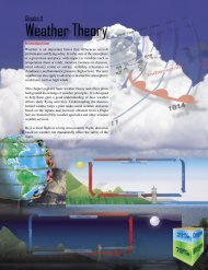
longer-term domestic and international forecasts are made using codes such as the AVN<br />
and MRF prognostic models. Forecasts are usually issued in three to six hour intervals for<br />
periods as short as three hours to as long as several days. AWC meteorologists use these<br />
forecast products and other available information to prepare Terminal Aerodrome<br />
Forecasts for U.S. airports, and to prepare advisories and alerts for weather conditions<br />
that may adversely affect aviation operations (e.g., SIGMETS and convective SIGMETs).<br />
In their present forms, models like the Eta and its counterparts are best suited for<br />
predicting the movement of synoptic scale meteorological features that affect the weather<br />
over regions larger than individual terminal areas and on time scales longer than are<br />
valuable for many aircraft operations. Thus, while these models are useful for general<br />
large-scale weather prediction, they have not been optimized to meet the specific needs of<br />
the aviation weather system. <strong>The</strong> FAA, NASA, MIT-LL, NOAA, and NCAR have been<br />
working on several new technologies designed to provide aviation-specific forecasts.<br />
FSL has developed an analysis and forecasting tool called the Mesoscale Analysis and<br />
Prediction System, which has been recently implemented at NCEP as the Rapid Update<br />
Cycle (RUC). <strong>The</strong> RUC combines objective analyses and short-term (less than 12 hr.)<br />
prediction tools to prepare gridded data sets of surface and upper-air meteorological<br />
conditions that affect aviation operations. <strong>The</strong> RUC is run at NCEP every three hours on<br />
a 60-km grid covering the CONUS, and produces an analysis of current conditions and 3-<br />
hourly forecasts out to 12 hours. An experimental 40 km version is being tested, and<br />
plans call for going to finer horizontal resolutions in the future.<br />
RUC products are currently being tested in new CNS/ATM and aviation weather<br />
technologies. For example, the current implementation of CTAS uses the 3D RUC wind<br />
fields to calculate aircraft descent trajectories. An important issue for the successful<br />
application of RUC data in CNS technologies like CTAS, Conflict Probe, and other flight<br />
management systems is the need for good information on the accuracy and repeatability of<br />
RUC variables (e.g., rms errors in upper-air wind analyses and forecasts). For example,<br />
some preliminary evaluations of RUC upper-air wind forecasts indicate that in the 0-1 hr.<br />
time frame rms errors in vector winds may be on the order of 2-3 m/s, increasing to 5-7<br />
m/s at the end of the RUC forecast period. Likewise, the sensitivity of CNS/ATM<br />
technologies to uncertainties in RUC variables needs to be examined. More information is<br />
also needed on how RUC data sets will be incorporated into the AGFS.<br />
<strong>The</strong> ITWS is an analysis and prediction tool that is currently being developed by MIT-LL<br />
for use in the terminal area. <strong>The</strong> ITWS ingests the RUC gridded wind fields, TDWR and<br />
NEXRAD wind data, ASR-9 weather reflectivity data, MDCRS observations,<br />
ASOS/AWOS and LLWAS data, and other available information. It analyses these data<br />
to determine storm cell locations and movement, areas of precipitation, locations and<br />
intensities of gust fronts and microbursts, low-level winds affecting runway operations,<br />
locations of tornadoes, and other aviation impact variables. It predicts storm cell<br />
movement and the locations of gust fronts at 10 minute and 20 minute intervals from the<br />
analysis time. ITWS also produces three-dimensional gridded fields of winds on scales<br />
varying from 2 km near the terminal area to 60 km at the outer extent of the ITWS<br />
97