Gairloch - Scottish Rock Volume 2 - Pesda Press
Gairloch - Scottish Rock Volume 2 - Pesda Press
Gairloch - Scottish Rock Volume 2 - Pesda Press

Create successful ePaper yourself
Turn your PDF publications into a flip-book with our unique Google optimized e-Paper software.
<strong>Gairloch</strong> BEINN A’ MHUINIDH<br />
131<br />
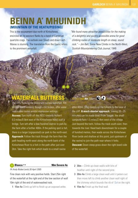
BEINN A’ MHUINIDH<br />
(mountain of the heath/pissing)<br />
This is the escarpment due north of Kinlochewe, “We found many attractive possibilities for the making<br />
encircled on its western flanks by a band of Cambrian of a delightful and quickly accessible arena for good<br />
quartzite crags. The outlook over Slioch and down Loch climbing routes of moderate length on steep, sound<br />
Maree is stunning. The translation from the Gaelic refers rock.” – Jim Bell, Some New Climbs in the North-West,<br />
to the prominent waterfall.<br />
<strong>Scottish</strong> Mountaineering Club Journal, 1949<br />
DESCENT<br />
2<br />
1<br />
WATERFALL BUTTRESS<br />
The cliffs flanking the prominent narrow waterfall, Allt<br />
an Still (swift stream), though a bit broken, offer some<br />
reasonable routes amidst impressive settings.<br />
Access: Turn north off the A832 towards Incheril<br />
0.3 miles/0.5km east of the Kinlochewe Hotel over a<br />
bridge. Turn left after a few hundred metres to park by<br />
the farm after a further 400m. If the parking spot is full,<br />
there is a larger (signposted) car park to the north-east.<br />
Approach: Follow the track through the farm then the<br />
path heading north-west along the north bank of the<br />
Kinlochewe River to a fork in the path after just over<br />
2km. Take the right fork which leads to a small ravine<br />
NH 024 649 Alt: 300m<br />
aF ad 11/4hr<br />
after 400m. Slog steeply up the hillside to the base of<br />
the cliff. A much shorter approach, (saving 20 – 25<br />
minutes) can be made direct from Taagan, the small<br />
campsite/farm 1.5 miles/2.4km west of the village.<br />
Just beyond the farm, follow the track south-east, then<br />
towards the river. Head back downstream for a couple<br />
of hundred metres, then wade across the Kinlochewe<br />
River (wide and shallow at this point, just upstream of<br />
the ravine) to join the path near where it forks.<br />
Descent: Down steep grass down the right (east) side<br />
of the waterfall.<br />
• 1 Blanco 2<br />
FA Andy Nisbet (solo) 26 April 2005<br />
90m Severe 4a<br />
Fine clean rock with very positive holds. Start 25m right<br />
of the waterfall at the right end of the low section of wall<br />
10m right of the end of waterwashed rock.<br />
1 15m 4a Climb up left to finish up an exposed arête.<br />
2 30m – Climb up clean walls with bits of<br />
heather until right of the second pine.<br />
3 30m 4a Climb a large clean wall until it peters out<br />
then move left to climb another clean wall right of<br />
the chimney which bounds the rib of Tuit on the right.<br />
4 15m 4a Finish up the final wall.