file size reduced version, 1.38 MB - Geoscience BC
file size reduced version, 1.38 MB - Geoscience BC file size reduced version, 1.38 MB - Geoscience BC
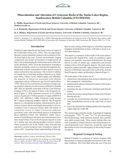
Min er al iza tion and Al ter ation of Cre ta ceous Rocks of the Taseko Lakes Re gion, Southwestern British Columbia (NTS 092O/04) L. Hollis, Department of Earth and Ocean Sciences, University of British Columbia, Vancouver, BC, lhollis@eos.ubc.ca L.A. Kennedy, Department of Earth and Ocean Sciences, University of British Columbia, Vancouver, BC K.A. Hickey, Department of Earth and Ocean Sciences, University of British Columbia, Vancouver, BC Hollis, L., Ken nedy, L.A. and Hickey, K.A. (2009): Min er al iza tion and al ter ation of Cre ta ceous rocks of the Taseko Lakes re gion, south - west ern Brit ish Co lum bia (NTS 092O/04); in Geoscience BC Sum mary of Ac tiv i ties 2008, Geoscience BC, Re port 2009-1, p. 71–86. Introduction Por phyry cop per de pos its are the ma jor source of cop per in the world to day (Titley et al., 1981). They are large hy dro - ther mal sys tems in ti mately re lated to the exsolution of flu - ids from high in the crust. Tec tonic en vi ron ments, magma com po si tion and crustal en vi ron ment of em place ment all play a role in de ter min ing the metal en dow ment of these de - pos its (Rich ards, 2003). From the dis tri bu tion of por phyry de pos its around the world, it is clear that the mag matic-hy - dro ther mal sys tems re spon si ble for their gen e sis oc cur in pulses re stricted in time and space. The west ern Cor dil lera of Can ada has sev eral large por phyry de pos its (e.g., High - land Val ley, Ga lore Creek, Is land Cop per and Gi bral tar), the ma jor ity of which are as so ci ated with al ka line magmatism and are of Me so zoic age (Lowell and Guilbert, 1970). There are less well-known oc cur rences of large cop - per por phyry de pos its in other ter ranes of Brit ish Co lum bia (BC) that are spa tially as so ci ated with the Coast Plutonic Com plex (CPC); the larg est of these is the Pros per ity de - posit (Fig ure 1). With es ti mated re sources of 9.4 mil lion ounces of gold and 3.5 bil lion pounds of cop per (MINFILE 092O 041; MINFILE, 2008), Pros per ity could be come BC’s larg est pro duc ing por phyry de posit. The Pros per ity de posit is a calcalkaline por phyry char ac ter ized by the in - tru sion of quartz diorite and plagioclase por phyry into sur - round ing Lower Cre ta ceous ma rine shale and ma rine to nonmarine Lower to Up per Cre ta ceous andesitic pyroclastic rocks with in ter ca lated mas sive to por phy ritic flows (MINFILE 092O 041; MINFILE, 2008). Oc cur - rences of hy dro ther mal al ter ation and min er al iza tion have been found within 25 km of the Pros per ity de posit in rocks of a sim i lar age and paleogeographic-tec tonic set ting. These oc cur rences lie in the Taseko Lakes area and may rep re sent a tectono-tem po ral suite of por phyry cop per de - pos its in BC. Ac quir ing a better un der stand ing of their age, Keywords: por phyry, cop per, hy dro ther mal, Taseko Lakes This pub li ca tion is also avail able, free of charge, as col our dig i tal files in Adobe Ac ro bat ® PDF for mat from the Geoscience BC website: http://www.geosciencebc.com/s/DataReleases.asp. their tec tonic set ting and the de gree to which they rep re sent mag matic-hy dro ther mal sys tems, will make it eas ier to ac - cess these deposits. This re port is a sum mary of the re sults of the main au thor’s Geoscience BC-funded M.Sc. study on a por phyry cop per de posit and spa tially as so ci ated hy dro ther mal show ings that lie in rocks of sim i lar age, com po si tion and tec tonic set ting to those of the Pros per ity de posit. The study area is lo cated in south west ern BC, ap prox i mately 50 km south of the town of Wil liams Lake and 25 km south of the well-de - fined Pros per ity cop per-gold por phyry de posit (Fig ure 1). The main goals of the pro ject are to char ac ter ize min er al og i cal and chem i cal al ter ation and their paragenetic re la tion ships; un der stand the physicochemical evo lu tion of the hy dro - ther mal sys tems; de ter mine the age of in tru sion, al ter ation and min er al - iza tion; de fine the tec tonic and geo log i cal frame work of hy dro - ther mal ac tiv ity; con sider the hy dro ther mal show ings’ as so ci a tion to other hy dro ther mal ac tiv ity in the same belt of rocks; and as sess the po ten tial for find ing an other belt of por phyry cop per de pos its within BC. The cur rent pa per pres ents re sults of geo log i cal map ping, pe trog ra phy, 206 Pb/ 238 U and 40 Ar/ 39 Ar geo chron ol ogy, thermochronology, fluid in clu sion anal y sis and a pre lim i - nary sta ble iso tope study. These re sults in di cate that a pe - riod of por phyry-re lated in tru sion and min er al iza tion oc - curred dur ing the Late Cre ta ceous, around the same time that sim i lar events were tak ing place in the nearby Pros per - ity de posit. Regional Geological Setting Brit ish Co lum bia is com posed of var i ous orogenic belts that are part of a larger geo graphic area known as the Ca na - dian Cor dil lera. The Coast Belt forms the core of the lon - Geoscience BC Re port 2009-1 75
- Page 2 and 3: Fig ure 1. Lo ca tion of ma jor al
- Page 4 and 5: Lithological Units Tchaikazan River
- Page 6 and 7: Fig ure 4. Plots show ing geo chron
- Page 8 and 9: Fig ure 6. Com par i son of fea tur
- Page 10 and 11: Fig ure 7. Thermochronology re sult
- Page 12 and 13: Pri mary fluid in clu sions (P) wer
- Page 14 and 15: Fig ure 11. Sta ble iso tope anal y
- Page 16: ence dur ing the 2008 field sea son
Min er al iza tion and Al ter ation of Cre ta ceous Rocks of the Taseko Lakes Re gion,<br />
Southwestern British Columbia (NTS 092O/04)<br />
L. Hollis, Department of Earth and Ocean Sciences, University of British Columbia, Vancouver, <strong>BC</strong>,<br />
lhollis@eos.ubc.ca<br />
L.A. Kennedy, Department of Earth and Ocean Sciences, University of British Columbia, Vancouver, <strong>BC</strong><br />
K.A. Hickey, Department of Earth and Ocean Sciences, University of British Columbia, Vancouver, <strong>BC</strong><br />
Hollis, L., Ken nedy, L.A. and Hickey, K.A. (2009): Min er al iza tion and al ter ation of Cre ta ceous rocks of the Taseko Lakes re gion, south -<br />
west ern Brit ish Co lum bia (NTS 092O/04); in <strong>Geoscience</strong> <strong>BC</strong> Sum mary of Ac tiv i ties 2008, <strong>Geoscience</strong> <strong>BC</strong>, Re port 2009-1, p. 71–86.<br />
Introduction<br />
Por phyry cop per de pos its are the ma jor source of cop per in<br />
the world to day (Titley et al., 1981). They are large hy dro -<br />
ther mal sys tems in ti mately re lated to the exsolution of flu -<br />
ids from high in the crust. Tec tonic en vi ron ments, magma<br />
com po si tion and crustal en vi ron ment of em place ment all<br />
play a role in de ter min ing the metal en dow ment of these de -<br />
pos its (Rich ards, 2003). From the dis tri bu tion of por phyry<br />
de pos its around the world, it is clear that the mag matic-hy -<br />
dro ther mal sys tems re spon si ble for their gen e sis oc cur in<br />
pulses re stricted in time and space. The west ern Cor dil lera<br />
of Can ada has sev eral large por phyry de pos its (e.g., High -<br />
land Val ley, Ga lore Creek, Is land Cop per and Gi bral tar),<br />
the ma jor ity of which are as so ci ated with al ka line<br />
magmatism and are of Me so zoic age (Lowell and Guilbert,<br />
1970). There are less well-known oc cur rences of large cop -<br />
per por phyry de pos its in other ter ranes of Brit ish Co lum bia<br />
(<strong>BC</strong>) that are spa tially as so ci ated with the Coast Plutonic<br />
Com plex (CPC); the larg est of these is the Pros per ity de -<br />
posit (Fig ure 1). With es ti mated re sources of 9.4 mil lion<br />
ounces of gold and 3.5 bil lion pounds of cop per (MINFILE<br />
092O 041; MINFILE, 2008), Pros per ity could be come<br />
<strong>BC</strong>’s larg est pro duc ing por phyry de posit. The Pros per ity<br />
de posit is a calcalkaline por phyry char ac ter ized by the in -<br />
tru sion of quartz diorite and plagioclase por phyry into sur -<br />
round ing Lower Cre ta ceous ma rine shale and ma rine to<br />
nonmarine Lower to Up per Cre ta ceous andesitic<br />
pyroclastic rocks with in ter ca lated mas sive to por phy ritic<br />
flows (MINFILE 092O 041; MINFILE, 2008). Oc cur -<br />
rences of hy dro ther mal al ter ation and min er al iza tion have<br />
been found within 25 km of the Pros per ity de posit in rocks<br />
of a sim i lar age and paleogeographic-tec tonic set ting.<br />
These oc cur rences lie in the Taseko Lakes area and may<br />
rep re sent a tectono-tem po ral suite of por phyry cop per de -<br />
pos its in <strong>BC</strong>. Ac quir ing a better un der stand ing of their age,<br />
Keywords: por phyry, cop per, hy dro ther mal, Taseko Lakes<br />
This pub li ca tion is also avail able, free of charge, as col our dig i tal<br />
<strong>file</strong>s in Adobe Ac ro bat ® PDF for mat from the <strong>Geoscience</strong> <strong>BC</strong><br />
website: http://www.geosciencebc.com/s/DataReleases.asp.<br />
their tec tonic set ting and the de gree to which they rep re sent<br />
mag matic-hy dro ther mal sys tems, will make it eas ier to ac -<br />
cess these deposits.<br />
This re port is a sum mary of the re sults of the main au thor’s<br />
<strong>Geoscience</strong> <strong>BC</strong>-funded M.Sc. study on a por phyry cop per<br />
de posit and spa tially as so ci ated hy dro ther mal show ings<br />
that lie in rocks of sim i lar age, com po si tion and tec tonic<br />
set ting to those of the Pros per ity de posit. The study area is<br />
lo cated in south west ern <strong>BC</strong>, ap prox i mately 50 km south of<br />
the town of Wil liams Lake and 25 km south of the well-de -<br />
fined Pros per ity cop per-gold por phyry de posit (Fig ure 1).<br />
The main goals of the pro ject are to<br />
char ac ter ize min er al og i cal and chem i cal al ter ation and<br />
their paragenetic re la tion ships;<br />
un der stand the physicochemical evo lu tion of the hy dro -<br />
ther mal sys tems;<br />
de ter mine the age of in tru sion, al ter ation and min er al -<br />
iza tion;<br />
de fine the tec tonic and geo log i cal frame work of hy dro -<br />
ther mal ac tiv ity;<br />
con sider the hy dro ther mal show ings’ as so ci a tion to<br />
other hy dro ther mal ac tiv ity in the same belt of rocks;<br />
and<br />
as sess the po ten tial for find ing an other belt of por phyry<br />
cop per de pos its within <strong>BC</strong>.<br />
The cur rent pa per pres ents re sults of geo log i cal map ping,<br />
pe trog ra phy,<br />
206 Pb/ 238 U and 40 Ar/ 39 Ar geo chron ol ogy,<br />
thermochronology, fluid in clu sion anal y sis and a pre lim i -<br />
nary sta ble iso tope study. These re sults in di cate that a pe -<br />
riod of por phyry-re lated in tru sion and min er al iza tion oc -<br />
curred dur ing the Late Cre ta ceous, around the same time<br />
that sim i lar events were tak ing place in the nearby Pros per -<br />
ity de posit.<br />
Regional Geological Setting<br />
Brit ish Co lum bia is com posed of var i ous orogenic belts<br />
that are part of a larger geo graphic area known as the Ca na -<br />
dian Cor dil lera. The Coast Belt forms the core of the lon -<br />
<strong>Geoscience</strong> <strong>BC</strong> Re port 2009-1 75
Fig ure 1. Lo ca tion of ma jor al ka line and calcalkaline cop per por phyry de pos its in <strong>BC</strong>. The in set map<br />
shows the lo ca tion of the Pros per ity de posit, past pro duc ers Pellaire (gold mine), Taseko-Em press<br />
(cop per-gold de vel oped pros pect) and Tay lor Wind fall (gold mine), and the Taseko Lakes study area.<br />
gest moun tain belt in the west ern Cor dil lera (Rusmore and<br />
Woodsworth, 1991) and is the su ture zone be tween the<br />
Intermontane Belt (to the east) and the In su lar Belt (to the<br />
west). The Taseko Lakes re gion of south west <strong>BC</strong> is lo cated<br />
near the east ern limit of the CPC. It is along this bound ary<br />
that the Pros per ity de posit is lo cated (Fig ure 1). The<br />
batholith is thought to have been pro duced, from the Ju ras -<br />
sic to the Eocene, by the subduction of the In su lar<br />
Superterrane along the con ti nen tal mar gin of North Amer -<br />
ica.<br />
In south west <strong>BC</strong>, the Coast Belt is di vided into the south -<br />
west and south east Coast belts. The south west Coast Belt<br />
con sists of Mid dle Ju ras sic to mid-Cre ta ceous plutonic<br />
rocks and Early Cre ta ceous vol ca nic rocks. The south east<br />
Coast Belt in cludes Early Cre ta ceous arc rocks and clastic<br />
rocks. The study area is lo cated within the south east Coast<br />
Belt, and in cludes rocks that be long to the Cre ta ceous<br />
Tchaikazan River suc ces sion and the Powell Creek For ma -<br />
tion (Tip per, 1969, 1978; Mc Laren, 1990; Mon ger et al.,<br />
1994; Schiarizza et al., 1997; Is rael, 2001).<br />
Is rael (2001) con cluded that the study area strad dles the<br />
bound ary be tween the Gam bier arc and the Tyaughton Ba -<br />
sin, and sug gested that the up lift of Early Cre ta ceous rocks<br />
pro vided a source of ma te rial for the Tyaughton Ba sin. By<br />
mid-Cre ta ceous time, the plate con fig u ra tion had changed,<br />
lead ing to dom i nantly contractional de for ma tion. Dextral<br />
strike-slip and contractional fault move ments oc curred in<br />
the area from the mid-Cre ta ceous to the Ter tiary (Journeay<br />
and Fried man, 1993; Schiarizza et al., 1997; Is rael et al.,<br />
2006). Dur ing the later Paleocene to Eocene ep ochs,<br />
contractional move ment was su per seded by dom i nantly<br />
dextral strike-slip move ment, form ing large-scale faults<br />
(e.g., Tchaikazan and Yalakom faults).<br />
Ev i dence for hy dro ther mal ac tiv ity and min er al iza tion is<br />
wide spread through out the south east Coast Belt, high -<br />
lighted by nu mer ous small me tal lic show ings, de vel oped<br />
pros pects and al tered hostrocks. These are largely as so ci -<br />
ated with, and lo cated prox i mal to, the in tru sions con tained<br />
within Lower to Up per Cre ta ceous ma rine and nonmarine<br />
sed i men tary and andesitic vol ca nic rocks, which are par tic -<br />
u larly well-de vel oped in the Tchaikazan River suc ces sion<br />
and the Powell Creek For ma tion.<br />
Local Geology<br />
Rocks in the study area range from Perm ian to Early Cre ta -<br />
ceous in age. The two main units rec og nized are the Early<br />
Cre ta ceous vol cano-sed i men tary Tchaikazan River suc ces -<br />
sion and the Late Cre ta ceous Powell Creek For ma tion (Fig -<br />
ure 2a; Mc Laren, 1990; Is rael, 2001). Sev eral large, northdip<br />
ping nor mal faults are ex posed and a large, east-strik ing<br />
thrust sheet, which placed the Tchaikazan River suc ces sion<br />
on top of the Powell Creek For ma tion, di vides the area.<br />
These units host sev eral cop per show ings, the three larg est<br />
of which are re ferred to as Hub, Char lie and North west<br />
Cop per (Fig ure 2a).<br />
76 <strong>Geoscience</strong> <strong>BC</strong> Sum mary of Ac tiv i ties 2008
<strong>Geoscience</strong> <strong>BC</strong> Re port 2009-1 77<br />
Fig ure 2. Maps of the Taseko Lakes study area high light ing: a) the three min eral show ings (Hub, Char lie and North west Cop per) and the ma jor struc tural and geo log i cal bound aries; b) mag -<br />
netic anom a lies that re veal the in ferred subsurface ex tents of ig ne ous bod ies.
Lithological Units<br />
Tchaikazan River Succession<br />
The old est pack ages of rocks lo cated in the study area are<br />
the ap prox i mately 1 km thick (Is rael, 2001) vol cano-sed i -<br />
men tary pack ages of the Tchaikazan River suc ces sion (Fig -<br />
ure 2a), which is split into vol ca nic- and sed i men tary-dom -<br />
i nated fa cies. The vol ca nic fa cies is char ac ter ized by<br />
in ter ca lated sub aque ous to subaerial vol ca nic rocks, typ i -<br />
cally andesitic in com po si tion, and mas sive an de site flows<br />
dom i nate its up per parts. The sed i men tary fa cies is char ac -<br />
ter ized by ma rine sed i men tary rocks that are highly vari -<br />
able in terms of grain <strong>size</strong>, bed thick ness, struc ture and rock<br />
type (Hollis et al., 2008), in clud ing me dium to coarsegrained,<br />
well-sorted sand stone, con glom er ate, siltstone,<br />
and mudstone.<br />
Is rael (2001) sug gested that the Tchaikazan River suc ces -<br />
sion could be as old as 136 Ma, maybe even 146 Ma, and a<br />
min i mum depositional age is con strained by the Mt.<br />
Pilkington in tru sion that cross cuts the suc ces sion and<br />
yields a Pb/U zir con age of 102 ±2 Ma. The Pb/U dat ing of<br />
zir cons for this study yielded ages of 80.7 ±0.8 Ma and 76.6<br />
±0.7 Ma for two feld spar por phyry dikes that cross cut the<br />
vol ca nic fa cies of the Tchaikazan River suc ces sion.<br />
The rocks of the Tchaikazan River suc ces sion can be sub di -<br />
vided into three lithological as so ci a tions: 1) pri mary vol ca -<br />
nic, 2) sed i men tary (ei ther vol ca nic or sed i men tary de -<br />
rived) and 3) hypa bys sal. Pri mary vol ca nic fa cies are<br />
gen er ally the prod uct of ef fu sive vol ca nic erup tion, while<br />
hypa bys sal in tru sions in clude dikes that are mostly dis cor -<br />
dant to stra tig ra phy and sed i men tary fa cies in clude those<br />
formed where vol ca nic pro cesses have had no in flu ence<br />
upon de po si tion, but can nev er the less com prise vol ca nicde<br />
rived ma te rial.<br />
The Tchaikazan River suc ces sion likely rep re sents a ma -<br />
rine rock se quence de pos ited near an ac tive arc re gion. The<br />
in crease in vol ca nic ma te rial to wards the strati graphic top<br />
of the suc ces sion sug gests a pro gres sive in crease in arc-re -<br />
lated vol ca nism. The calcalkaline sig na tures of the vol ca -<br />
nic rocks place them into vol ca nic arc re lated and mar ginalba<br />
sin set tings.<br />
Powell Creek Formation<br />
The youn gest for ma tion in the study area is the Powell<br />
Creek For ma tion, char ac ter ized by an ex ten sive pack age of<br />
interbedded, nonmarine, subaerial vol ca nic and<br />
volcaniclastic rocks. Mas sive vol ca nic flow units, brec cia<br />
flows and resedimented volcaniclastic rocks dom i nate the<br />
for ma tion. The Powell Creek For ma tion is in ferred to be at<br />
least 93.5 ±0.8 to 89.3 ±1 Ma in age (Schiarizza et al., 1997).<br />
The non ho mo ge neous fa cies of the Powell Creek For ma -<br />
tion are highly vari able, con sist ing of mas sive, poorly sor -<br />
ted, ma trix-sup ported volcaniclastic units of sand stone,<br />
siltstone and brec cia. The pre dom i nantly rounded or an gu -<br />
lar clasts lack chilled mar gins, ves i cle zonation or ra dial<br />
joint ing pat terns and are in ter nally mas sive. Dif fer en tial<br />
weath er ing of clasts to the sur round ing ma trix ma te rial is<br />
fre quently ob served, caus ing clasts to pro trude from the<br />
host ma trix (Hollis et al., 2006). The an de site clasts are of -<br />
ten plagioclase phyric and hosted within an apha ni tic, dark<br />
ma roon an de site.<br />
The Powell Creek For ma tion shows as pects of mass flow,<br />
trac tion and sus pen sion, yield ing resedimented<br />
(syneruptive) volcaniclastic de pos its. Sand-<strong>size</strong>d par ti cles<br />
likely dom i nated sed i men ta tion pro cesses dur ing<br />
aggradation, as in di cated by the pres ence of large vol umes<br />
of coarse crys tal line ma te rial (par tic u larly feld spar and<br />
quartz) shed from the sur round ing vol ca nic en vi ron ment.<br />
The weath er ing, ero sion and re work ing of vol ca nic ma te -<br />
rial pro duced a wide spread volcanogenic sed i men tary de -<br />
posit.<br />
Intrusive Rocks<br />
The study area is host to a va ri ety of in tru sive rocks, rang -<br />
ing from dikes to larger plutonic bod ies, the larg est of<br />
which is lo cated within the Tchaikazan River val ley and is<br />
known as the Hub diorite (Fig ures 2, 3). It is this diorite that<br />
hosts much of the por phyry-style min er al iza tion ob served<br />
at the Hub por phyry de posit (see be low).<br />
Hub Intrusive Centre<br />
A suite of sev eral ig ne ous rocks char ac ter izes the Hub por -<br />
phyry de posit; out crops are dom i nated by coarsely crys tal -<br />
line, mas sive, por phy ritic diorite com posed of plagioclase<br />
(~50%), bi o tite (10–25%) and hornblende (25%) pheno -<br />
crysts in an apha ni tic, plagioclase-dom i nated groundmass.<br />
The 40 Ar/ 39 Ar (bi o tite and hornblende) and 206 Pb/ 238 U (zir -<br />
con) geo chron ol ogy con strained the age of the Hub diorite<br />
to ca. 80 Ma (Fig ures 3, 4a–c). The Hub diorite is cut by an<br />
unmineralized plug of equigranular monzonite as well as<br />
by a 5 m wide feld spar-hornblende por phyry dike which,<br />
though unmineralized, con tains up to 7% py rite. Sam ples<br />
from this sin gle feld spar-hornblende dike from the in tru -<br />
sive cen tre yielded an age of ca. 70 Ma. Feld spar por phyry<br />
dikes con sid ered to be part of this in tru sive cen tre were also<br />
sam pled from the Char lie show ing area, where they cross -<br />
cut the Early Cre ta ceous rocks of the Tchaikazan River suc -<br />
ces sion (see above); these yielded ages of 80.7 ±0.8 Ma,<br />
77.49 ±0.97 Ma and 76.6 ±0.7 Ma (Fig ure 4–f).<br />
Northwest Copper Intrusive Centre<br />
The youn gest in tru sive rock in the study area is the North -<br />
west Cop per pluton, which is ex posed in the west ern por -<br />
tion of the study area (Fig ure 2). It is fel sic in com po si tion,<br />
con tain ing ap prox i mately 40% quartz, 30% plagioclase<br />
and 30% other min er als, in clud ing bi o tite and hornblende.<br />
78 <strong>Geoscience</strong> <strong>BC</strong> Sum mary of Ac tiv i ties 2008
This com plex in tru sion, char ac ter ized by sev eral<br />
compositional vari a tions, con tains nu mer ous round xe no -<br />
liths of the Powell Creek For ma tion and cross cut ting aplite<br />
dikes. The North west Cop per pluton yielded a Pb/U zir con<br />
age of 57.33 ±0.85 Ma (Fig ure 4g), while a diorite dike<br />
prox i mal to the North west Cop per pluton gave a 40 Ar/ 39 Ar<br />
hornblende cool ing age of 60.01 ±0.46 Ma (Fig ure 4h). A<br />
small plug of equigranular syenite that oc curs on the north -<br />
ern part of Rav i oli ridge (Fig ure 2) com prises >60%<br />
anhedral neph el ine crys tals, 30% quartz and 10%<br />
hornblende.<br />
Other Intrusive Rocks<br />
Through out the study area, nu mer ous feld spar-hornblende<br />
dikes of un known age cross cut the Cre ta ceous vol ca nic<br />
rocks. These dikes are highly al tered and do not ap pear to<br />
be re lated to the ig ne ous cen tres, but could be re lated to the<br />
Tchaikazan Rap ids pluton (ca. 6 Ma; Is rael, 2001), which is<br />
found to the north of the study area. Subsurface in tru sions<br />
are in ferred from the aero mag net ic data (Fig ure 2b). Some<br />
mag netic highs cor re spond well to known in tru sive bod ies<br />
even though they are sit ting in vol ca nic rocks; oth ers are in -<br />
ter preted as rep re sent ing subsurface in tru sions (Fig ure 2 b)<br />
that are pre sum ably sim i lar in age to the Hub or North west<br />
Cop per in tru sive rocks.<br />
Structure<br />
Thrusts<br />
Large, contractional, north-verg ing thrust faults plac ing<br />
an de site rocks of the Tchaikazan River suc ces sion atop the<br />
youn ger Powell Creek For ma tion are a dom i nant fea ture in<br />
the study area. These faults, dip ping mod er ately to the<br />
south west and gen er ally strik ing east (Fig ure 2), are char -<br />
ac ter ized by gouge-rich zones that are up to sev eral metres<br />
thick. Tim ing of thrust ing is not well con strained, but a<br />
sam ple of fine-grained illite col lected from one of these<br />
large thrust zones yielded a 40 Ar/ 39 Ar cool ing age of<br />
60.53 ±0.33 Ma (Blevings, 2008).<br />
The north west ern part of the mapped area is dis sected by a<br />
large nor mal fault (Fig ure 2) that jux ta poses the early<br />
Tchaikazan River suc ces sion next to the Powell Creek For -<br />
ma tion; it is in ferred to dip steeply to the north and to have a<br />
nor mal off set. The Tchaikazan fault, ob served to the north<br />
of Rav i oli ridge, is a south east-strik ing, high-an gle, right<br />
lat eral fault (Fig ure 2; Is rael, 2001). It is the larg est struc -<br />
ture ob served in the area, with a strike length of nearly<br />
200 km and sug gested dextral off set of 8 km (Is rael, 2001).<br />
Mesoscale stri ated fault sur faces are com mon in many parts<br />
of the study area, but the lack of good mark ing units pre -<br />
vents de ter min ing the ex tent of dis place ment. These fault<br />
sur faces are par tic u larly well-de vel oped in the Char lie<br />
show ing area and around the thrusted area, where faults<br />
typ i cally dip >50º, strike north west and have un known ki -<br />
Fig ure 3. Maps of the Hub por phyry de posit and sur round ing Char -<br />
lie dikes show ing: a) geo log i cal and b) geo chron ol ogi cal data.<br />
ne mat ics. The fault zones are rel a tively nar row, steeply dip -<br />
ping to the south (>60º) and vis i ble over sev eral tens of<br />
metres. Shear zones, brit tle frac tur ing and vein den sity in -<br />
crease to the north west of the Tchaikazan River val ley.<br />
Character of Alteration and Mineralization<br />
The study area can be di vided into three do mains show ing<br />
ev i dence for hy dro ther mal al ter ation re ferred to as the Hub<br />
por phyry, the Char lie show ing (where gold-bear ing veins<br />
were pre vi ously re ported) and the North west Cop per show -<br />
ing (where na tive cop per and chal co py rite-bear ing veins<br />
have been ob served).<br />
Hub Porphyry<br />
The Hub por phyry, hosted in the Hub diorite, is lo cated<br />
within the Tchaikazan River val ley and ex posed along the<br />
Tchaikazan River it self (Fig ures 2, 3). Ex po sure is gen er -<br />
ally poor and lim ited to a few hun dred metres along man-<br />
<strong>Geoscience</strong> <strong>BC</strong> Re port 2009-1 79
Fig ure 4. Plots show ing geo chron ol ogi cal data: a)<br />
206 Pb/ 238 U age de ter mi na tion for the Hub diorite; b) 40 Ar/ 39 Ar (bi o tite)<br />
age de ter mi na tion for Hub diorite; c)<br />
40 Ar/ 39 Ar (bi o tite) age de ter mi na tion for the diorite phase at the Hub show ing; d)<br />
206 Pb/ 238 U age de ter mi na tion for the cross cut ting dike at Char lie show ing; e) 206 Pb/ 238 U (zir con) age de ter mi na tion for a<br />
sim i lar feld spar por phyry dike at the Char lie show ing; f) 40 Ar/ 39 Ar (hornblende) cool ing age de ter mi na tion for the same<br />
dike as in e); g) 206 Pb/ 238 U (zir con) age de ter mi na tion for the North west Cop per pluton; and h) 40 Ar/ 39 Ar hornblende cool -<br />
ing age de ter mi na tion for the diorite dike at the North west Copper showing.<br />
80 <strong>Geoscience</strong> <strong>BC</strong> Sum mary of Ac tiv i ties 2008
made geo log i cal trenches and to drillcore from four<br />
drillholes. Hy dro ther mal ac tiv ity is pre served by a phase of<br />
hy dro ther mal brec cia and bi o tite-mag ne tite al ter ation, lo -<br />
cally in tense seri cite and propylitic al ter ation, and chal co -<br />
py rite±bornite±mo lyb de nite min er al iza tion.<br />
Alteration<br />
Hydrothermal Breccia<br />
A mag ne tite-bi o tite–al tered hy dro ther mal brec cia (Fig -<br />
ures 5, 6a, b) is vol u met ri cally the sec ond-most prom i nent<br />
rock type ob served at the Hub show ing, af ter the dom i nant<br />
diorite phase (see above). Re cent drill ing has shown the<br />
brec cia ex tends to a depth of at least 260 m (Fig ure 5). The<br />
hy dro ther mal brec cia typ i cally con sists of ~60% ma trix/ce -<br />
ment, 30% clast ma te rial and 0–10% open space. Frag -<br />
ments are dom i nated by com po si tions re flect ing the im me -<br />
di ate wallrocks, in clud ing fine-grained an de site, diorite,<br />
quartz-vein frag ments (Fig ure 6c, d) and rare monzonite.<br />
Most of the frag ments, es pe cially those of diorite and<br />
monzonite, are subangular to subrounded and typ i cally<br />
mea sure a few centi metres in di am e ter; how ever, it ap pears<br />
that blocks of an de site (metres in <strong>size</strong>), likely rep re sent ing<br />
pieces of the host wallrocks, are pres ent within the stra tig -<br />
ra phy. The brec cia is most com mon in the up per parts of<br />
drillholes, where it forms along the mar gin of a gently<br />
south east erly () dip ping sheet of Hub diorite.<br />
Biotite-Magnetite Alteration<br />
Brown, fine-grained bi o tite is the dom i nant al ter ation min -<br />
eral in the hy dro ther mal brec cia, but it also con tains vari -<br />
able amounts of mag ne tite and quartz (Fig ure 6). The bi o -<br />
tite-mag ne tite as sem blage is con fined to the Hub show ing.<br />
Hy dro ther mal bi o tite typ i cally re places mag matic bi o tite<br />
and hornblende, and is of ten pseudomorphed by later<br />
chlorite.<br />
Sericite Alteration<br />
Seri cite par tially re places plagioclase pheno crysts lo cally<br />
within the Hub diorite. In tense seri cite al ter ation is ob -<br />
served within the youn gest feld spar-hornblende dike at the<br />
Hub show ing. Weak to mod er ate seri cite al ter ation is ob -<br />
served through out the Hub diorite, where fine-grained seri -<br />
cite se lec tively re places plagioclase pheno crysts.<br />
Fig ure 5. Cross-sec tion of four drillholes from the Hub por phyry look ing north east show ing rock types, al ter ation and min er al iza tion. In set<br />
map shows the in ferred mag netic anom aly.<br />
<strong>Geoscience</strong> <strong>BC</strong> Re port 2009-1 81
Fig ure 6. Com par i son of fea tures ob served from drillcore and out crop within the mag ne tite-bi o tite–al tered hy dro ther mal brec cia: a) hole<br />
08TSK-02 sam ple (depth of 100.2 m) show ing the con tact be tween the Hub diorite and the hy dro ther mal brec cia; b) same re la tion ship as<br />
ob served in (a) for sam ple taken from trenches at the Hub show ing; c) hole 08TSK-06 (depth of 89 m), show ing clastic brec cia with an de site<br />
and quartz vein clasts; and d) same tex tural and compositional re la tion ship as ob served in (c).<br />
Chlorite-Epidote (Propylitic) Al ter ation<br />
Chlorite re places pri mary bi o tite, plagioclase and<br />
hornblende lo cally in the Hub diorite; sec ond ary bi o tite of<br />
the mag ne tite-bi o tite al ter ation is also pseudomorphed by<br />
chlorite (see above). Fine-grained epidote al ter ation is rare.<br />
Later chlorite al ter ation has af fected the mag matic, dis sem -<br />
i nated and vein re place ment bi o tite in the potassic al ter -<br />
ation zone.<br />
Mineralization<br />
The Hub por phyry con tains cop per and mo lyb de nite min er -<br />
al iza tion. The min er al iza tion takes sev eral forms, in clud -<br />
ing those of sul phide-bear ing quartz stockwork vein ing,<br />
dis sem i nated sulphides in the Hub diorite and sul phide<br />
phases as ce ment in the hy dro ther mal brec cia. Chal co py -<br />
rite, bornite, mo lyb de nite and ga lena are among the com -<br />
mon sul phide min eral as sem blages ob served. Dis sem i -<br />
nated chal co py rite, py rite and rare bornite and ga lena were<br />
ob served within rocks of the Hub diorite and the hy dro ther -<br />
mal brec cia. Dis sem i nated sulphides are typ i cally 5 cm thick) through out the<br />
drillcore. Frac ture-coats of fine-grained mo lyb de nite were<br />
ob served in the Hub diorite. In the hy dro ther mal brec cia,<br />
chal co py rite and py rite ex hibit void-fill ing or in ter sti tial<br />
tex tures.<br />
Stable Isotope Results<br />
A to tal of four quartz veins and one mag ne tite vein were<br />
sam pled us ing stan dard mean ocean wa ter (SMOW) anal y -<br />
sis. The quartz veins typ i cally hosted chal co py rite min er al -<br />
iza tion and mea sured up to 1 cm in thick ness. The suite of<br />
quartz veins from the Hub diorite dis played ä 18 O (SMOW)<br />
rock val ues rang ing from 8.7 to 10.3, while the mag ne tite<br />
vein yielded a ä 18 O rock value of 3.4. These val ues cor re -<br />
82 <strong>Geoscience</strong> <strong>BC</strong> Sum mary of Ac tiv i ties 2008
late with typ i cal val ues for hy dro ther mal flu ids de rived<br />
from a mag matic source.<br />
Depth of Emplacement<br />
The evo lu tion of por phyry cop per de pos its is strongly af -<br />
fected by the depth of em place ment and the ef fect this has<br />
on the sol u bil ity of volatiles and met als in the hy dro ther mal<br />
fluid. Fluid in clu sion sam ples were pre pared from sev eral<br />
veins from the Hub diorite, but yielded no in de pend ent ev i -<br />
dence of pres sure and, hence, depth. In stead, low-tem per a -<br />
ture fis sion-track thermochronology was used in an at tempt<br />
to re con struct the depth at which min er al iza tion oc curred,<br />
as this tech nique can pro vide es ti mates of ex hu ma tion.<br />
A sam ple of the Hub diorite was col lected from the val ley<br />
base for zir con (ZFT) and ap a tite (AFT) fis sion track anal y -<br />
sis (Fig ure 7a, b). A sam ple from the Hub in tru sive com plex<br />
yielded a ZFT date of 85.6 ±1.8 Ma, which cor re sponds to<br />
the time of em place ment of the Hub diorite de ter mined<br />
from Ar/Ar and Pb/U dat ing (Fig ure 3). In the case of geo -<br />
log i cally re al is tic ex hu ma tion rates, the clo sure tem per a -<br />
ture for ZFT is 200–240ºC (Reiners and Brandon, 2006).<br />
The cor re spon dence be tween Pb/U, Ar/Ar and ZFT de ter -<br />
mi na tions im plies that the Hub diorite cooled to be low<br />
200–240 ºC im me di ately af ter em place ment which; for<br />
geo ther mal gra di ents of 25–30ºC/km, would im ply an em -<br />
place ment depth of
Fig ure 7. Thermochronology re sults and re lated cross-sec tion show ing a) ap a tite fis sion track age vs. el e va tion plot (m) for five sam ples of<br />
Cre ta ceous in tru sive rocks col lected within the Taseko Lakes study area and best-fit line through the data that yields an av er age ex hu ma -<br />
tion rate of 55 to 30 Ma; b) ta ble of the col lected thermochronology sam ples’ char ac ter, lo ca tion and el e va tion; and c) sche matic cross-sec -<br />
tion of the study area from north west to south east, re con struct ing the sur face ex pres sion at 6 km (80 Ma), 4 km (30 Ma) and pres ent-day.<br />
84 <strong>Geoscience</strong> <strong>BC</strong> Sum mary of Ac tiv i ties 2008
Fig ure 8. Lo ca tion of al ter ation zones in the Taseko Lakes study area show ing al ter -<br />
ation min er als and al ter ation as sem blages, in clud ing the ‘propylitic’ chlorite-epidote,<br />
‘ad vanced argillic’ clay-dom i nated and ‘potassic’ bi o tite-mag ne tite al ter ation zones.<br />
styles of min er al iza tion are de scribed in greater de tail be -<br />
low:<br />
Comb-tex ture, sul phide-bear ing quartz veins are a style<br />
of vein char ac ter ized by mas sive, comb tooth quartz<br />
with a cen tre-fill of chal co py rite or py rite, and rare ga -<br />
lena. Veins are on av er age 2 cm thick, reach ing a max i -<br />
mum thick ness of 5 cm.<br />
Coarse tetrahedrite, mal a chite, and az ur ite. Tetrahedrite<br />
was lo cated in nu mer ous sam ples from a subcrop of<br />
quartz-dia spore vein ma te rial; it is typ i cally coarsegrained<br />
and ac counts for up to 5% of the vein ma te rial.<br />
Mal a chite and az ur ite were de vel oped in the si lici fied<br />
ma te rial sur round ing the tetrahedrite-bear ing zone.<br />
String ers of, and dis sem i nated na tive cop per were lo -<br />
cated in two lo ca tions near the North west Cop per thrust<br />
fault. The na tive cop per was as so ci ated with milky<br />
white, mas sive quartz veinlets. Mal a chite and<br />
chrysocolla al ter ation around the veins was an in di ca tor<br />
to their cop per con tent. Na tive cop per veins are also re -<br />
ported from the south ern part of Rav i oli ridge.<br />
<br />
Epidote-chal co py rite-py rite-mag ne tite veins oc cur<br />
only within the area of the North west Cop per show ing,<br />
prox i mal to the North west Cop per pluton. Chal co py rite<br />
is typ i cally coarse grained and as so ci ated with py rite<br />
and mi nor coarse mag ne tite. Mag ne tite forms thin, dis -<br />
con tin u ous string ers as so ci ated with the epidote and<br />
chal co py rite. Py rite forms mas sive ag gre gates in centi -<br />
metre-thick veins. The veins typ i cally ex hibit 1–5 cm<br />
wide al ter ation selvages of illite and chlorite.<br />
Fluid Inclusion Analysis<br />
A to tal of ten dou bly pol ished thin sec tions of quartz vein<br />
ma te rial were cho sen af ter petrographic anal y sis us ing<br />
plane po lar ized light. Many of the typ i cally coarse-grained<br />
and mas sive veins were host to sul phide min er al iza tion.<br />
The fluid in clu sions within were vari able in type, dis tri bu -<br />
tion pat tern, ho mog e ni za tion tem per a ture, phase con tent<br />
and vol ume-per cent vapour, a pat tern com monly found in<br />
other por phyry cop per de pos its.<br />
<strong>Geoscience</strong> <strong>BC</strong> Re port 2009-1 85
Pri mary fluid in clu sions (P) were rarely suf fi ciently de vel -<br />
oped, or too small, to be readily an a lyzed (Fig ure 10). This<br />
is not un com mon in sam ples from the por phyry en vi ron -<br />
ment and is the rea son be hind the need to an a lyze larger in -<br />
clu sions. Growth zones in quartz crys tals are the usual host<br />
to these P in clu sions (Fig ure 10a); how ever, these were too<br />
small for anal y sis (
proved in con clu sive in gen er at ing a paleodepth or re al is tic<br />
tem per a ture for the mag matic-hy dro ther mal system.<br />
Stable Isotope Results<br />
A to tal of nine sam ples of vein cal cite were taken from ar eas<br />
of the Char lie and North west Cop per show ings (re sults<br />
shown in Fig ure 11a–c). These veins were typ i cally mas -<br />
sive cal cite-only veins or quartz veins with a cal cite cen trefill.<br />
The sam ples dis play ä 13 C fluid val ues rang ing from<br />
–9.853 to –3.265, and ä 18 O fluid val ues, from 5.891 to<br />
11.088 (Fig ure 11c). These val ues are within the range of<br />
val ues sug gested as cor re spond ing to a deep-seated or mag -<br />
matic source for the CO 2 car bon which is char ac ter ized by<br />
ä 13 C fluid val ues rang ing from –3 to –8, with a mean at<br />
–6 per mil (Ford and Green, 1977; Dreher et al., 2008).<br />
How ever, Kerrich and Wyman (1990) stated that the same<br />
sig na ture could be cre ated by leach ing of car bon ate<br />
hostrocks or ox i da tion of free car bon, and does not nec es -<br />
sar ily in di cate that the CO 2 is of man tle or mag matic or i gin.<br />
There fore the C and O iso tope data pre sented in this re port<br />
do not clearly dis crim i nate be tween the pos si ble fluid<br />
sources.<br />
The suite of quartz veins from the Hub show ing dis played<br />
ä 18 O (SMOW) rock val ues rang ing from 8.7 to 10.3 (Fig -<br />
ure 11a). These veins dis play typ i cal ig ne ous val ues (Tay -<br />
lor, 1968), whereas sam ples taken from the Char lie and<br />
North west Cop per show ings re vealed ä 18 O val ues pro -<br />
gress ing out ward from the Hub por phyry (Fig ure 11b).<br />
Sam ples from quartz-mag ne tite veins near the North west<br />
Cop per pluton yielded for ma tion tem per a tures of 490ºC for<br />
ä 18 O from coprecipitating quartz and mag ne tite (Fig -<br />
ure 11b), cal cu lated us ing iso tope frac tion ation data to gain<br />
an ap pro pri ate tem per a ture of for ma tion. A kaolinite min -<br />
eral sam ple from the North west Cop per ‘ad vanced argillic’<br />
al ter ation zone yielded a ä 18 O rock value of 6.6, and a äH<br />
rock value of –113 (Fig ure 11a).<br />
Interpretation<br />
The Hub por phyry sys tem dis plays the ig ne ous, al ter ation<br />
and met al lo gen ic sig na tures of a calcalkaline cop per por -<br />
phyry de posit. Min er al iza tion is hosted in the 80 Ma Hub<br />
diorite and cut by 69 Ma feld spar-hornblende dikes, con -<br />
strain ing the age of min er al iza tion to be tween ca. 80 and<br />
70 Ma. The Hub diorite ap pears to have been emplaced at a<br />
depth of 5–6 km at this time. Thrust ing at ap prox i mately<br />
60 Ma led to the place ment of the Tchaikazan River suc ces -<br />
sion over the Powell Creek For ma tion. Sub se quent ex hu -<br />
ma tion at a rate of 40 m/Ma from 80 to 31 Ma and of<br />
>100 m/Ma from 31 Ma to the pres ent day gives a depth of<br />
3–4 km.<br />
The dom i nance of the potassic min eral as sem blage (higher<br />
tem per a ture hy dro ther mal al ter ation) at the Hub por phyry<br />
is in ferred to be prox i mal to the cen tre of the por phyry sys -<br />
tem. Weak seri cite al ter ation oc curs as a lower tem per a ture<br />
over print. There is no phys i cal ev i dence of a fault lo cated<br />
be tween the Hub and Char lie show ings, nor would the re -<br />
con structed strati graphic re la tion ships re quire that one<br />
have oc curred. There fore, the ‘propylitic’ and ‘illite’ al ter -<br />
ations in the Char lie show ing area ap pear to be placed a true<br />
800 m above the core zone of potassic al ter ation at the Hub<br />
show ing and are thought to be a dis tal ex pres sion of the<br />
mag matic-hy dro ther mal sys tem. The strong vein-as so ci -<br />
ated epidote al ter ation of hostrocks and vein epidote lo -<br />
cated near thrust faults may well re flect hy dro ther mal ac -<br />
tiv ity as so ci ated with the de vel op ment of these struc tures<br />
post-por phyry ac tiv ity, around 60 Ma ago. Seri cite al ter -<br />
ation, which is most de vel oped on Rav i oli ridge, may lie<br />
above the in ferred subsurface in tru sion and there fore be a<br />
re sult of the dis tal ef fects of mag matic-de rived flu ids. The<br />
‘ad vanced argillic’ al ter ation zone rep re sents a near-sur -<br />
face al ter ation and its acidic na ture was likely a prod uct of<br />
acidic mag matic vapour con den sa tion. The epidote al ter -<br />
ation ap pears re lated to fluid flow around faults, and the<br />
North west Cop per pluton, sug gest ing a prob a ble hy dro -<br />
ther mal al ter ation age of ca. 60 Ma.<br />
Fig ure 10. Pho to mi cro graphs of fluid in clu sions as seen in plane-po lar ized light: a) pri mary fluid in clu sions in growth zones in quartz crys -<br />
tals; and b) sec ond ary fluid-in clu sion trail cross cut ting ear lier pri mary as sem blage.<br />
<strong>Geoscience</strong> <strong>BC</strong> Re port 2009-1 87
Fig ure 11. Sta ble iso tope anal y sis re sults and hy dro ther mal fluid tem per a ture plots: a) top o graphic map of the lo ca tion of sta ble iso tope<br />
sam ples taken from vein ma te rial and kaolinite rock sam ple high light ing the Hub, Char lie and North west Cop per show ings; b) ä 18 O plot for<br />
the min eral pair quartz-mag ne tite show ing that the quartz and mag ne tite veins at the North west Cop per show ing formed at ~490ºC, as de -<br />
ter mined us ing equa tions from Zhang et al. (1989) and Chacko et al. (2004) for Ä(A-B) = 10.8‰ (just within the lim its of nor mal ig ne ous<br />
rocks); and c) plot of ä 18 O vs. ä 13 C val ues for hy dro ther mal vein cal cite sam ples (see blue squares in(a)) for a hy poth e <strong>size</strong>d tem per a ture of<br />
300 ºC.<br />
Discussion and Implications<br />
The sim i lar ity of the ages and geo log i cal com po si tion of<br />
the in tru sive rocks of the Hub por phyry to those ob served in<br />
the Char lie show ing area sug gests that the min er al iza tion at<br />
both lo cal i ties may be linked to the same pe riod of<br />
magmatism re spon si ble for the 77 Ma Pros per ity de posit.<br />
The North west Cop per show ing is dif fer ent in terms of<br />
min er al ogy, al ter ation and age, and is prob a bly linked to<br />
sep a rate mag matic ac tiv ity, per haps a youn ger hy dro ther -<br />
mal event re lated to the thrust ing at around 60–55 Ma.<br />
The Hub por phyry de posit is the same age as other de pos its<br />
in the re gion, in par tic u lar the 80 Ma Taseko-Em press<br />
show ing (Fig ure 1; see Blevings, 2008) and the larger Pros -<br />
per ity de posit. The same age and sim i lar depth of the Hub<br />
por phyry, Taseko-Em press and Pros per ity de pos its may<br />
point to an 80 Ma suite of por phyry de pos its formed by<br />
subduction-re lated magmatism that was ca pa ble of pro duc -<br />
ing por phyry-style min er al iza tion. The por phyry sys tem at<br />
Taseko Lakes formed at the deep end of the spec trum of<br />
known por phyry de pos its (Sillitoe, 1972, 1973). Given the<br />
cal cu lated AFT and ZFT depth of the Hub por phyry, two<br />
pos si bil i ties arise: Ei ther much of the over ly ing de posit has<br />
been lost, or the por phyry de posit was in her ently smaller or<br />
per haps trun cated (by thrust ing of the late Cre ta ceous<br />
crunch) por phyry de posit. While these Cre ta ceous rocks<br />
do pres ent ev i dence of mag matic hy dro ther mal al ter ation,<br />
the ev i dence sup port ing their abil ity to host Pros per itystyle<br />
min er al iza tion is lim ited.<br />
Conclusions<br />
The Cre ta ceous ig ne ous rocks of the Tchaikazan River suc -<br />
ces sion and Powell Creek For ma tion are host to cop per<br />
min er al iza tion which oc curred be tween ca. 80 and 70 Ma<br />
(Fig ure 12). Min er al ized cen tres in this area in clude the<br />
Hub diorite, prox i mal to the North west Cop per pluton, and<br />
the small, vein-re lated Char lie show ing. The char ac ter of<br />
the min er al iza tion and the hy dro ther mal al ter ation is typ i -<br />
cal of that at trib uted to por phyry de pos its. High tem per a -<br />
ture potassic al ter ation is con fined to the core of the Hub<br />
por phyry and is char ac ter ized by bi o tite-mag ne tite al ter -<br />
ation of the hy dro ther mal brec cia. Dis tal re gions are al tered<br />
to a chlorite-epidote-cal cite al ter ation that can, and should,<br />
be dif fer en ti ated from an in tense epidote-only al ter ation as -<br />
sem blage prox i mal to fault zones. Seri cite al ter ation is lo -<br />
cally re stricted and is per va sive in late cross cut ting feld -<br />
spar-hornblende dikes as so ci ated with the Hub por phyry.<br />
The ages for the struc tures in the study area are not wellcon<br />
strained, but an illite (Ar/Ar) age for a thrust fault at the<br />
North west Cop per show ing yielded an age of<br />
60.53 ±0.33 Ma, which in di cates that min er al iza tion likely<br />
oc curred post-de for ma tion or dur ing the same pe riod of<br />
88 <strong>Geoscience</strong> <strong>BC</strong> Sum mary of Ac tiv i ties 2008
Fig ure 12. Sche matic di a gram de pict ing the evo lu tion of the Hub show ing’s hy dro ther mal sys tem in the Taseko Lakes study area: a) a large<br />
granodiorite pluton at depth de vel ops a cu pola at its top; b) quartz-mag ne tite and quartz-sul phide veins form, af ter vol a tile in put from depth;<br />
c) brecciation of the granodiorite and sur round ing an de site wallrocks oc curs, infill of mag ne tite, bi o tite and quartz oc curs as ce ment; and d)<br />
cool ing of the mag matic sys tem and in tru sion of feld spar por phyry dikes at ca. 70 Ma.<br />
magmatism as the 57 Ma North west Cop per pluton. This<br />
age is con sis tent with that of the Poi son Moun tain<br />
(Cu±Mo±Au) por phyry pros pect, where K-Ar dat ing<br />
(hornblende and bi o tite) has yielded an age of 59–56 Ma<br />
(MINFILE 092O 046; MINFILE, 2008) for the in tru sion,<br />
potassic al ter ation and min er al iza tion.<br />
Both sta ble iso tope stud ies and microthermometric data<br />
from fluid in clu sion anal y sis on the Taseko Lakes area<br />
proved un cer tain. How ever, low-tem per a ture<br />
thermochronology us ing AFT and ZFT pro vided an es ti -<br />
mated av er age ero sion rate of 40 m/Ma, which in di cates<br />
that the por phyry sys tem was emplaced at a depth of 5–<br />
6 km. The sim i lar ity in age, com po si tion, min er al ogy and<br />
geo log i cal set ting of the Hub por phyry to that of the neigh -<br />
bour ing Pros per ity de posit is en cour ag ing, and in di cates<br />
that Late Cre ta ceous con di tions were con du cive to pro duc -<br />
ing large por phyry cop per de pos its.<br />
The re sults gath ered over three field sea sons of work in di -<br />
cate that the Taseko Lakes area dis plays ev i dence of por -<br />
phyry-style in tru sion, al ter ation and min er al iza tion. The<br />
re la tion ships de rived from field map ping and lab o ra tory<br />
work pro vide a use ful back ground for the ef fec tive con tin -<br />
ued ex plo ra tion of the study area.<br />
Acknowledgments<br />
The au thors would like to thank J. Mortensen for re view ing<br />
this pa per prior to sub mis sion and Ga lore Re sources Inc.<br />
for their lo gis ti cal sup port. Thanks also go to Eq uity Ex plo -<br />
ra tion Con sul tants for pro vid ing in valu able field ex pe ri -<br />
<strong>Geoscience</strong> <strong>BC</strong> Re port 2009-1 89
ence dur ing the 2008 field sea son and ac cess to drill ing in -<br />
for ma tion. Ga lore Re sources Inc. and <strong>Geoscience</strong> <strong>BC</strong> are<br />
thanked for their fi nan cial con tri bu tion to the pro ject.<br />
References<br />
Blevings, S.K. (2008): Geo logic frame work for Late Cre ta ceous<br />
mag matic-hy dro ther mal min er al iza tion in the Taseko Lakes<br />
re gion, south west ern B.C.; M.Sc. the sis, Uni ver sity of Brit -<br />
ish Co lum bia, 244 p.<br />
Chacko, T., Cole, D.R. and Horita, J. (2001): Equi lib rium ox y gen,<br />
hy dro gen and car bon iso tope frac tion ation fac tors ap pli ca -<br />
ble to geo logic sys tems; Re views in Min er al ogy and Geo -<br />
chem is try, v. 43, no. 1, p. 1–81.<br />
Dreher, A.M., Xa vier, R.P., Tay lor, B.E. and Mar tini, S.L. (2008):<br />
New geo logic, fluid in clu sion and sta ble iso tope stud ies on<br />
the Con tro ver sial Igarapé Bahia Cu-Au de posit, Carajá<br />
Prov ince, Brazil; Mineralium Deposita, v. 43, no. 2, p. 161–<br />
184.<br />
Ford, J. H. and Green, D. C. (1977): An ox y gen- and hy dro gen-iso -<br />
tope study of the Panguna por phyry-cop per de posit,<br />
Bougainville; Aus tra lian Jour nal of Earth Sci ences, v. 24,<br />
no. 1-2, p. 63–80, doi: 10.1080/00167617708728967.<br />
Hollis, L., Blevings, S.K., Cham ber lain, C.M., Hickey, K.A. and<br />
Ken nedy, L.A. (2006): Min er al iza tion, al ter ation, and struc -<br />
ture of the Taseko Lakes re gion, south west ern Brit ish Co -<br />
lum bia: pre lim i nary anal y sis; in <strong>Geoscience</strong> <strong>BC</strong> Sum mary<br />
of Ac tiv i ties, <strong>Geoscience</strong> <strong>BC</strong>, Re port 2007-1, p. 297–306.<br />
Hollis, L., Hickey, K. and Ken nedy, L.A. (2008): Min er al iza tion<br />
and al ter ation as so ci ated with an hy poth e <strong>size</strong>d cop per (mo -<br />
lyb de num) por phyry sys tem in the Taseko Lakes area,<br />
south west ern Brit ish Co lum bia (NTS 092O/04); in<br />
<strong>Geoscience</strong> <strong>BC</strong> Sum mary of Ac tiv i ties, <strong>Geoscience</strong> <strong>BC</strong>, Re -<br />
port 2008-1, p. 55–66.<br />
Is rael, S. (2001): Struc tural and strati graphic re la tion ships within<br />
the Tchaikazan River area, south west ern Brit ish Co lum bia:<br />
im pli ca tions for the tec tonic evo lu tion of the south ern Coast<br />
Belt; M.Sc. the sis,, Uni ver sity of Brit ish Co lum bia, 129 p.<br />
Is rael, S., Ken nedy, L.A., Schiarizza, P., Fried man, R.M. and<br />
Villeneuve, M. (2006): Ev i dence for Early to Late Cre ta -<br />
ceous, sinistral de for ma tion in the Tchaikazan River area,<br />
south west ern Brit ish Co lum bia: im pli ca tions for the tec -<br />
tonic evo lu tion of the south ern Coast Belt; in<br />
Paleogeography of the west ern North Amer i can Cor dil lera,<br />
J. Haggart, R.J. Enkin and J.W.H. Mon ger (ed.), Geo log i cal<br />
As so ci a tion of Can ada, Spe cial Pa per 46, p. 331–350.<br />
Journeay, J. M. and Fried man, R.M. (1993): The Coast Belt Thrust<br />
Sys tem: ev i dence of Late Cre ta ceous short en ing in south -<br />
west Brit ish Co lum bia; Tec ton ics, v. 12, no. 3, p. 756–775.<br />
Kerrich, R. and Wyman, D. (1990): Geodynamic set ting of<br />
mesothermal gold de pos its: an as so ci a tion with accretionary<br />
tec tonic re gimes; Ge ol ogy, v. 18, no. 9, p. 882–885.<br />
Lowell, D.J. and Guilbert, J.M. (1970): Lat eral and ver ti cal al ter -<br />
ation-min er al iza tion zon ing in por phyry ore de pos its; Eco -<br />
nomic Ge ol ogy, v. 65, no. 4, p. 373–408.<br />
Mc Laren, G. P. (1990): A min eral re source as sess ment of the<br />
Chilko Lake plan ning area; <strong>BC</strong> Min is try of En ergy, Mines<br />
and Pe tro leum Re sources, Bul le tin 81, 117 p.<br />
MINFILE (2008): MINFILE <strong>BC</strong> min eral de pos its da ta base; <strong>BC</strong><br />
Min is try of En ergy, Mines and Pe tro leum Re sources, URL<br />
[Oc to ber 2008].<br />
Mon ger, J. W. H., van der Heyden, P. J., Journeay, M., Evenchick,<br />
C. A. and Mahoney, J. B. (1994): Ju ras sic-Cre ta ceous bas ins<br />
along the Ca na dian Coast Belt; their bear ing on pre-Mid-<br />
Cre ta ceous sinistral dis place ments; Ge ol ogy, v. 22, p. 175–<br />
178.<br />
Reiners, P.W. and Brandon, M.T. (2006): Us ing thermochronology<br />
to un der stand orogenic ero sion; An nual Re view of Earth and<br />
Plan e tary Sci ences, v. 34, p. 419–466.<br />
Rich ards, J.P. (2003): Tectono-mag matic pre cur sors for por phyry<br />
Cu-(Mo-Au) de posit for ma tion; Eco nomic Ge ol ogy, v. 98,<br />
no. 8, p. 1515–1533.<br />
Rusmore, M. E. and G. J. Woodsworth (1991): Coast Plutonic<br />
Com plex: a mid-Cre ta ceous contractional orogen; Ge ol ogy,<br />
v. 19, no. 9, p. 941–944.<br />
Schiarizza, P., Gaba, R.G., Glover, J.K., Garver, J.I. and Umhoefer,<br />
P.J. (1997): Ge ol ogy and min eral oc cur rences of the<br />
Taseko–Bridge River area; <strong>BC</strong> Min is try of En ergy, Mines<br />
and Pe tro leum Re sources, Bul le tin 100, 291 p.<br />
Sillitoe, R.H. (1972): A plate tec tonic model for the or i gin of por -<br />
phyry cop per de pos its; Eco nomic Ge ol ogy, v. 67, no. 2,<br />
p. 184–197.<br />
Sillitoe, R.H. (1973): The tops and bot toms of por phyry cop per de -<br />
pos its; Eco nomic Ge ol ogy, v. 68, no. 6, p. 799–815.<br />
Tay lor, H.P. (1968): The ox y gen iso tope geo chem is try of ig ne ous<br />
rocks; Con tri bu tions to Min er al ogy and Pe trol ogy, v. 19,<br />
no. 1, p. 1–70.<br />
Tip per, H.W. (1969): Me so zoic and Ce no zoic ge ol ogy of the<br />
north east part of the Mount Waddington map-area (92N),<br />
Coast dis trict, Brit ish Co lum bia. Geo log i cal Sur vey of Can -<br />
ada, Pa per 68-33.<br />
Tip per, H.W. (1978): Ge ol ogy of Taseko Lakes map-area (92 O),<br />
Brit ish Co lum bia; Geo log i cal Sur vey of Can ada, Open File<br />
534.<br />
Titley, S.R. and Beane, R.E. (1981): Por phyry cop per de pos its;<br />
part I, geo logic set tings, pe trol ogy, and tectonogenesis; Eco -<br />
nomic Ge ol ogy and the Bul le tin of the So ci ety of Eco nomic<br />
Ge ol o gists, v. 75, 214 p.<br />
Umhoefer, P.J. and Schiarizza, P. (1996): Lat est Cre ta ceous to<br />
early Ter tiary dextral strike-slip fault ing on the south east ern<br />
Yalakom fault sys tem, south east ern Coast Belt, Brit ish Co -<br />
lum bia; Geo log i cal So ci ety of Amer ica Bul le tin, v. 108,<br />
no. 7, p. 768–785.<br />
Zhang, X., Nesbitt, B. E. and Muehlenbachs, K. (1989): Gold min -<br />
er al iza tion in the Okanagan Val ley, south ern Brit ish Co lum -<br />
bia: fluid in clu sion and sta ble iso tope stud ies; Eco nomic<br />
Ge ol ogy, v. 84, no. 2, p. 410–424.<br />
90 <strong>Geoscience</strong> <strong>BC</strong> Sum mary of Ac tiv i ties 2008


