

Pájaro River Watershed Flood Protection Plan - The Pajaro River ...
Pájaro River Watershed Flood Protection Plan - The Pajaro River ...
Pájaro River Watershed Flood Protection Plan - The Pajaro River ...

Create successful ePaper yourself
Turn your PDF publications into a flip-book with our unique Google optimized e-Paper software.
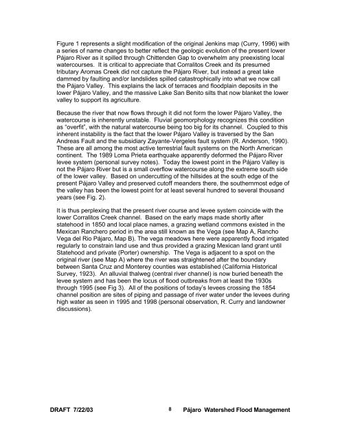
Figure 1 represents a slight modification of the original Jenkins map (Curry, 1996) with<br />
a series of name changes to better reflect the geologic evolution of the present lower<br />
<strong>Pájaro</strong> <strong>River</strong> as it spilled through Chittenden Gap to overwhelm any preexisting local<br />
watercourses. It is critical to appreciate that Corralitos Creek and its presumed<br />
tributary Aromas Creek did not capture the <strong>Pájaro</strong> <strong>River</strong>, but instead a great lake<br />
dammed by faulting and/or landslides spilled catastrophically into what we now call<br />
the <strong>Pájaro</strong> Valley. This explains the lack of terraces and floodplain deposits in the<br />
lower <strong>Pájaro</strong> Valley, and the massive Lake San Benito silts that now blanket the lower<br />
valley to support its agriculture.<br />
Because the river that now flows through it did not form the lower <strong>Pájaro</strong> Valley, the<br />
watercourse is inherently unstable. Fluvial geomorphology recognizes this condition<br />
as “overfit”, with the natural watercourse being too big for its channel. Coupled to this<br />
inherent instability is the fact that the lower <strong>Pájaro</strong> Valley is traversed by the San<br />
Andreas Fault and the subsidiary Zayante-Vergeles fault system (R. Anderson, 1990).<br />
<strong>The</strong>se are all among the most active terrestrial fault systems on the North American<br />
continent. <strong>The</strong> 1989 Loma Prieta earthquake apparently deformed the <strong>Pájaro</strong> <strong>River</strong><br />
levee system (personal survey notes). Today the lowest point in the <strong>Pájaro</strong> Valley is<br />
not the <strong>Pájaro</strong> <strong>River</strong> but is a small overflow watercourse along the extreme south side<br />
of the lower valley. Based on undercutting of the hillsides at the south edge of the<br />
present <strong>Pájaro</strong> Valley and preserved cutoff meanders there, the southernmost edge of<br />
the valley has been the lowest point for at least several hundred to several thousand<br />
years (see Fig. 2).<br />
It is thus perplexing that the present river course and levee system coincide with the<br />
lower Corralitos Creek channel. Based on the early maps made shortly after<br />
statehood in 1850 and local place names, a grazing wetland commons existed in the<br />
Mexican Ranchero period in the area still known as the Vega (see Map A, Rancho<br />
Vega del Rio <strong>Pájaro</strong>, Map B). <strong>The</strong> vega meadows here were apparently flood irrigated<br />
regularly to constrain land use and thus provided a grazing Mexican land grant until<br />
Statehood and private (Porter) ownership. <strong>The</strong> Vega is adjacent to a spot on the<br />
original river (see Map A) where the river was straightened after the boundary<br />
between Santa Cruz and Monterey counties was established (California Historical<br />
Survey, 1923). An alluvial thalweg (central river channel) is now buried beneath the<br />
levee system and has been the locus of flood outbreaks from at least the 1930s<br />
through 1995 (see Fig 3). All of the positions of today’s levees crossing the 1854<br />
channel position are sites of piping and passage of river water under the levees during<br />
high water as seen in 1995 and 1998 (personal observation, R. Curry and landowner<br />
discussions).<br />
DRAFT 7/22/03<br />
8<br />
<strong>Pájaro</strong> <strong>Watershed</strong> <strong>Flood</strong> Management

