Pájaro River Watershed Flood Protection Plan - The Pajaro River ...
Pájaro River Watershed Flood Protection Plan - The Pajaro River ... Pájaro River Watershed Flood Protection Plan - The Pajaro River ...
Fig 9: Lake San Benito “terrace” Fig 8: Recently abandoned active floodplain Fig 10. Abandoned floodplain surface 1 km north of Mitchell Road. Active channel on the left, Lake San Benito “terrace” on the right with power poles. View west, downstream. This is an example of easily recovered flood storage, now only 6-8 feet above the overwide (1 km) adjacent riverbed. DRAFT 7/22/03 58 Pájaro Watershed Flood Management
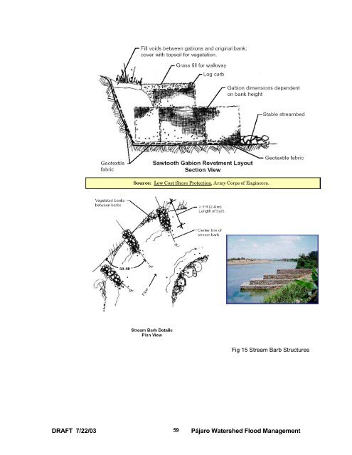
Fig 15 Stream Barb Structures DRAFT 7/22/03 59 Pájaro Watershed Flood Management
- Page 9 and 10: Map B. 1908 Parcel Map of a portion
- Page 11 and 12: Map A 1875 based on 1854 land surve
- Page 13 and 14: Upper Watershed, San Benito and San
- Page 15 and 16: Himalaya and Alaska are there possi
- Page 17 and 18: DRAFT 7/22/03 17 Pájaro Watershed
- Page 19 and 20: The current project attempts to rec
- Page 21 and 22: California State University Robert
- Page 23 and 24: where: g adj is the adjusted skew g
- Page 25 and 26: 70000 Hollister upper confidence in
- Page 27 and 28: value for the maximum possible 100-
- Page 29 and 30: Regional Analysis The trend in perc
- Page 31 and 32: Interestingly, the maximum consecut
- Page 33 and 34: California State University Robert
- Page 35 and 36: We also find that on the order of 6
- Page 37 and 38: Figure11 Cartoon showing how incisi
- Page 39 and 40: Although Hospital Road shows some a
- Page 41 and 42: clearly attenuate (reduce) flood pe
- Page 43 and 44: average 8-foot depth of water that
- Page 45 and 46: culverts and fill. Other parts of t
- Page 47 and 48: Our modeling of enhanced flood stor
- Page 49 and 50: APPENDICES & Figures APPENDIX 1: No
- Page 51 and 52: APPENDIX 5 Example of Historical Ch
- Page 53 and 54: APPENDIX 2: 1995 and 1998 Storm Com
- Page 55 and 56: http://12.45.109.6/pls/portal30/get
- Page 57 and 58: 50 Corralitos Creek Hydrograph & Co
- Page 59: Figure 16 - San Benito River channe
- Page 63 and 64: Corps’ Data presented Alternative
- Page 65 and 66: California State University Robert
- Page 67 and 68: . illustrations, on an interim repo
- Page 69 and 70: APPENDIX 3 Streambank Property Owne
- Page 71: Historical Change in San Benito Riv
Fig 15 Stream Barb Structures<br />
DRAFT 7/22/03<br />
59<br />
<strong>Pájaro</strong> <strong>Watershed</strong> <strong>Flood</strong> Management


