

Pájaro River Watershed Flood Protection Plan - The Pajaro River ...
Pájaro River Watershed Flood Protection Plan - The Pajaro River ...
Pájaro River Watershed Flood Protection Plan - The Pajaro River ...

You also want an ePaper? Increase the reach of your titles
YUMPU automatically turns print PDFs into web optimized ePapers that Google loves.
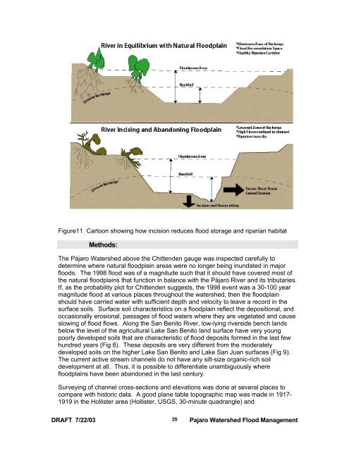
Figure11 Cartoon showing how incision reduces flood storage and riparian habitat<br />
Methods:<br />
<strong>The</strong> <strong>Pájaro</strong> <strong>Watershed</strong> above the Chittenden gauge was inspected carefully to<br />
determine where natural floodplain areas were no longer being inundated in major<br />
floods. <strong>The</strong> 1998 flood was of a magnitude such that it should have covered most of<br />
the natural floodplains that function in balance with the <strong>Pájaro</strong> <strong>River</strong> and its tributaries.<br />
If, as the probability plot for Chittenden suggests, the 1998 event was a 30-100 year<br />
magnitude flood at various places throughout the watershed, then the floodplain<br />
should have carried water with sufficient depth and velocity to leave a record in the<br />
surface soils. Surface soil characteristics on a floodplain reflect the depositional, and<br />
occasionally erosional, passages of flood waters where they are vegetated and cause<br />
slowing of flood flows. Along the San Benito <strong>River</strong>, low-lying riverside bench lands<br />
below the level of the agricultural Lake San Benito land surface have very young<br />
poorly developed soils that are characteristic of flood deposits formed in the last few<br />
hundred years (Fig 8). <strong>The</strong>se deposits are very different from the moderately<br />
developed soils on the higher Lake San Benito and Lake San Juan surfaces (Fig 9).<br />
<strong>The</strong> current active stream channels do not have any silt-size organic-rich soil<br />
development at all. Thus, it is possible to differentiate unambiguously where<br />
floodplains have been abandoned in the last century.<br />
Surveying of channel cross-sections and elevations was done at several places to<br />
compare with historic data. A good plane table topographic map was made in 1917-<br />
1919 in the Hollister area (Hollister, USGS, 30-minute quadrangle) and<br />
DRAFT 7/22/03<br />
35<br />
<strong>Pajaro</strong> <strong>Watershed</strong> <strong>Flood</strong> Management

