

Pájaro River Watershed Flood Protection Plan - The Pajaro River ...
Pájaro River Watershed Flood Protection Plan - The Pajaro River ...
Pájaro River Watershed Flood Protection Plan - The Pajaro River ...

Create successful ePaper yourself
Turn your PDF publications into a flip-book with our unique Google optimized e-Paper software.
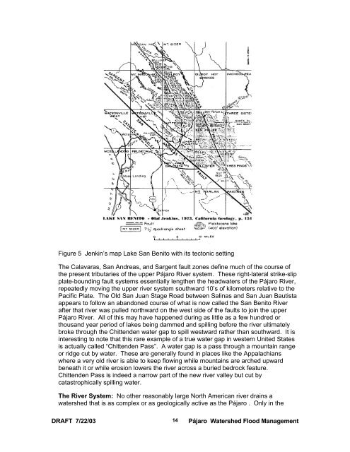
Figure 5 Jenkin’s map Lake San Benito with its tectonic setting<br />
<strong>The</strong> Calavaras, San Andreas, and Sargent fault zones define much of the course of<br />
the present tributaries of the upper <strong>Pájaro</strong> <strong>River</strong> system. <strong>The</strong>se right-lateral strike-slip<br />
plate-bounding fault systems essentially lengthen the headwaters of the <strong>Pájaro</strong> <strong>River</strong>,<br />
repeatedly moving the upper river system southward 10’s of kilometers relative to the<br />
Pacific Plate. <strong>The</strong> Old San Juan Stage Road between Salinas and San Juan Bautista<br />
appears to follow an abandoned course of what is now called the San Benito <strong>River</strong><br />
after that river was pulled northward on the west side of the faults to join the upper<br />
<strong>Pájaro</strong> <strong>River</strong>. All of this may have happened during as little as a few hundred or<br />
thousand year period of lakes being dammed and spilling before the river ultimately<br />
broke through the Chittenden water gap to spill westward rather than southward. It is<br />
interesting to note that this rare example of a true water gap in western United States<br />
is actually called “Chittenden Pass”. A water gap is a pass through a mountain range<br />
or ridge cut by water. <strong>The</strong>se are generally found in places like the Appalachians<br />
where a very old river is able to keep flowing while mountains are arched upward<br />
beneath it or while erosion lowers the river across a buried bedrock feature.<br />
Chittenden Pass is indeed a narrow part of the new river valley but cut by<br />
catastrophically spilling water.<br />
<strong>The</strong> <strong>River</strong> System: No other reasonably large North American river drains a<br />
watershed that is as complex or as geologically active as the <strong>Pájaro</strong> . Only in the<br />
DRAFT 7/22/03<br />
14<br />
<strong>Pájaro</strong> <strong>Watershed</strong> <strong>Flood</strong> Management

