Parameter Estimation Guidelines for Risk-Based Corrective Action ...
Parameter Estimation Guidelines for Risk-Based Corrective Action ...
Parameter Estimation Guidelines for Risk-Based Corrective Action ...

You also want an ePaper? Increase the reach of your titles
YUMPU automatically turns print PDFs into web optimized ePapers that Google loves.
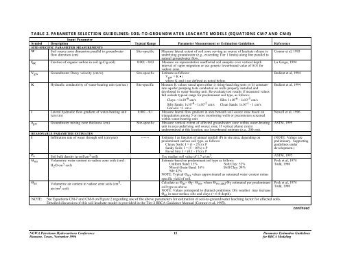
TABLE 2. PARAMETER SELECTION GUIDELINES: SOIL-TO-GROUNDWATER LEACHATE MODELS (EQUATIONS CM-7 AND CM-8)<br />
Input <strong>Parameter</strong><br />
Symbol Description Typical Range <strong>Parameter</strong> Measurement or <strong>Estimation</strong> <strong>Guidelines</strong> Reference<br />
SITE-SPECIFIC PARAMETER MEASUREMENTS<br />
W<br />
Soil source zone dimension parallel to groundwater<br />
flow direction (cm)<br />
Site-specific<br />
Measure lateral extent of soil zone serving as source of leachate release to<br />
underlying groundwater (e.g., exceeding Tier 1 limits) along line parallel to<br />
natural groundwater flow.<br />
f oc Fraction of organic carbon in soil (g-C/g-soil) 0.001 - 0.03 Measure on representative unaffected soil samples over vertical depth<br />
interval of vapor migration or use generic lowerbound value of 0.01 <strong>for</strong><br />
vadose zone.<br />
V gw Groundwater Darcy velocity (cm/w) Site-specific Estimate as follows:<br />
V gw = K • i<br />
where K and i are defined as noted below.<br />
K Hydraulic conductivity of water-bearing unit (cm/sec) Site-specific Measure K values vased upon either i) rising-head slug tests or ii) constantrate<br />
aquifer pumping tests conducted on wells properly installed and<br />
developed in water-bearing unit. Re-evaluate test results if measured values<br />
fall outside typical range <strong>for</strong> predominant soil type, as follows:<br />
Clays: 1 cm.s<br />
i<br />
Lateral hydraulic flow gradient of water-bearing unit 0.001 - 0.1 Measure lateral flow gradient in area beneath soil source zone based on<br />
(cm/cm)<br />
triangulation among 3 or more monitoring wells or piezometers screened<br />
within water-bearing unit.<br />
δ gw Groundwater mixing zone thickness (cm) Site-specific Measure vertical extent of affected groundwater zone within water-bearing<br />
unit in area underlying soil source zone. If vertical plume extent<br />
undetermined at this location, use lowerbound estimate (e.g., 200 cm).<br />
REASONABLE PARAMETER ESTIMATES<br />
I Infiltration rate of water through soil (cm/year) ------ Estimate I as function of annual rainfall (P) in site area, depending on<br />
predominant surface soil type, as follows:<br />
Clayey Soils: I = (1 - 2%) x P<br />
Sandy Soils: I = (5 - 10%) x P<br />
Paved Site: I = (0.1 - 1%) x P<br />
Connor et al, 1995<br />
La Grega, 1994<br />
Bedient et al, 1994<br />
Bedient et al, 1994<br />
Newell et al, 1996<br />
ASTM, 1995<br />
(NOTE: Values are<br />
preliminary. Supporting<br />
guidelines under<br />
development.)<br />
P s Soil bulk density (g-soil/cm 3 -soil) Use median soil value of 1.7 g/cm 3 . ASTM, 1995<br />
Θ ws<br />
Volumetric water content in vadose zone soils (cm3-<br />
H 2 O/cm 3 -soil)<br />
Θ as Volumetric air content in vadose zone soils (cm 3 -<br />
air/cm 3 -soil)<br />
NOTE:<br />
Estimate based on predominant soil type as follows:<br />
Uni<strong>for</strong>m Sand: 13% Soft Clay: 52%<br />
Mixed-Grain-Sand: 16% Stiff Clay: 34%<br />
Silt: 42%<br />
NOTE: Typical Θ ws values approximated as saturated water content minus<br />
specific yield of soil.<br />
Calculate as Θ as = Θ T - Θ ws , where Θ ws and Θ T estimated per predominant<br />
soil type as above.<br />
NOTE: Values correspond to drained conditions. Dry weather may increase<br />
Θ as in near-surface silts and clays (< 6 ft depth).<br />
See Equations CM-7 and CM-8 on Figure 2 regarding use of the above parameters <strong>for</strong> estimation of soil-to-groundwater leaching factor <strong>for</strong> affected soils.<br />
Detailed discussion of this soil leachate model is provided in the Tier 2 RBCA Guidance Manual (Connor et al, 1995).<br />
Peck et al, 1974<br />
Todd, 1980<br />
Peck et al, 1974<br />
Todd, 1980<br />
continued<br />
NGWA Petroleum Hydrocarbons Conference 15 <strong>Parameter</strong> <strong>Estimation</strong> <strong>Guidelines</strong><br />
Houston, Texas, November 1996<br />
<strong>for</strong> RBCA Modeling