Executive Summary of the 2008 State of the Watershed Report
Executive Summary of the 2008 State of the Watershed Report
Executive Summary of the 2008 State of the Watershed Report

Create successful ePaper yourself
Turn your PDF publications into a flip-book with our unique Google optimized e-Paper software.
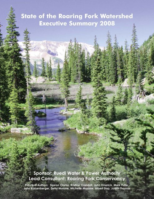
<strong>State</strong> <strong>of</strong> <strong>the</strong> Roaring Fork <strong>Watershed</strong><br />
<strong>Executive</strong> <strong>Summary</strong> <strong>2008</strong><br />
Sponsor: Ruedi Water & Power Authority<br />
Lead Consultant: Roaring Fork Conservancy<br />
Principal Authors: Sharon Clarke, Kristine Crandall, John Emerick, Mark Fuller,<br />
John Katzenberger, Delia Malone, Michelle Masone, Albert Slap, Judith Thomas
Paul Hilts<br />
Preface<br />
This “<strong>State</strong> <strong>of</strong> <strong>the</strong> <strong>Watershed</strong> <strong>Report</strong>,” which comprises<br />
Phase I <strong>of</strong> <strong>the</strong> Roaring Fork <strong>Watershed</strong> Plan, is <strong>the</strong><br />
product <strong>of</strong> dedicated effort by a host <strong>of</strong> people including<br />
technical experts, government planners and administrators,<br />
conservation pr<strong>of</strong>essionals, and water managers.<br />
Also involved are residents<br />
<strong>of</strong> <strong>the</strong> Roaring Fork <strong>Watershed</strong><br />
who care about issues<br />
<strong>of</strong> water quality and<br />
quantity and have<br />
expressed that caring by<br />
participating in <strong>the</strong> public<br />
meetings, forums, and<br />
interviews that have been<br />
part <strong>of</strong> this project. We<br />
would like to thank all <strong>of</strong> <strong>the</strong>se participants for <strong>the</strong>ir<br />
time, energy, and thoughtfulness and to invite <strong>the</strong>m,<br />
along with all o<strong>the</strong>r readers <strong>of</strong> this report, to stay<br />
involved in <strong>the</strong> future phases <strong>of</strong> <strong>the</strong> Roaring Fork<br />
<strong>Watershed</strong> Plan.<br />
The <strong>Watershed</strong> Plan had its origins in <strong>the</strong> Roaring<br />
Fork <strong>Watershed</strong> Collaborative, an informal group <strong>of</strong><br />
planners, government <strong>of</strong>ficials, and interested citizens<br />
who began meeting several years ago to discuss issues <strong>of</strong><br />
valleywide interest including transportation, affordable<br />
housing, open space and trails, and, <strong>of</strong> course, water.<br />
That group eventually appointed a Water Subcommittee<br />
to focus on <strong>the</strong> need to address water concerns in<br />
<strong>the</strong> valley without regard to political or jurisdictional<br />
boundaries. When <strong>the</strong> Ruedi Water and Power Authority<br />
and Roaring Fork Conservancy took on <strong>the</strong>ir respective<br />
roles <strong>of</strong> institutional overseer and principal author<br />
<strong>of</strong> <strong>the</strong> <strong>Watershed</strong> Plan, <strong>the</strong> project developed real<br />
momentum. All who will benefit from this plan owe<br />
gratitude to <strong>the</strong> groups and individuals who had a role<br />
in this work and to <strong>the</strong> elected and appointed <strong>of</strong>ficials<br />
who encouraged <strong>the</strong>m to think beyond <strong>the</strong>ir own<br />
bureaucratic boundaries.<br />
Few question that healthy water resources, along<br />
with air, soil, wildlife, and vegetation, are critical to <strong>the</strong><br />
maintenance <strong>of</strong> a healthy environment and to <strong>the</strong><br />
outdoors-oriented lifestyle enjoyed by those <strong>of</strong> us who<br />
live in <strong>the</strong> Roaring Fork <strong>Watershed</strong>. Two things set<br />
water apart from <strong>the</strong>se o<strong>the</strong>r basic resources. First, water<br />
is inherently scarce in some areas and becoming more<br />
so. Despite an occasional heavy snow year like 2007-08,<br />
ample evidence exists that <strong>the</strong> arid West is becoming<br />
more arid, and that increasing development and population<br />
will bring ever more pressure to bear on existing<br />
water resources. Second, water, at least in Colorado, is<br />
bought and sold in <strong>the</strong> open marketplace as a commodity.<br />
This means that water management is <strong>of</strong>ten subject<br />
to <strong>the</strong> ebbs and flows <strong>of</strong> <strong>the</strong> free market economy and<br />
also to <strong>the</strong> interests <strong>of</strong> those who own water rights.<br />
These two factors add unique challenges to any<br />
attempts at water resource planning. However, it has<br />
been clear from <strong>the</strong> beginning <strong>of</strong> this process that a<br />
Roaring Fork <strong>Watershed</strong> Plan is needed and welcomed<br />
both by those who are charged with managing local<br />
water resources and by <strong>the</strong> public at large.<br />
The following report illustrates <strong>the</strong> current status <strong>of</strong><br />
<strong>the</strong> Roaring Fork <strong>Watershed</strong> in terms <strong>of</strong> its water quality<br />
and quantity and its water-dependent ecosystems. It also<br />
points out areas where insufficient data prevent an<br />
accurate assessment <strong>of</strong> that status. Finally, <strong>the</strong> report<br />
provides a starting point for Phase II <strong>of</strong> <strong>the</strong> Plan, which<br />
will translate <strong>the</strong> data and findings in <strong>the</strong> report into<br />
recommended action steps aimed at preserving and<br />
enhancing local water resources.<br />
The next step in <strong>the</strong> Roaring Fork <strong>Watershed</strong> Plan<br />
will be <strong>the</strong> development <strong>of</strong> a series <strong>of</strong> goals and objectives,<br />
which are based on <strong>the</strong> findings <strong>of</strong> <strong>the</strong> <strong>State</strong> <strong>of</strong> <strong>the</strong><br />
<strong>Watershed</strong> <strong>Report</strong>.<br />
These goals and<br />
objectives <strong>the</strong>n will<br />
be translated into<br />
action steps that<br />
can be taken by<br />
water managers,<br />
governments, and<br />
individual water<br />
users. This Phase II<br />
<strong>of</strong> <strong>the</strong> Plan will move forward through 2009 and eventually<br />
will be turned over to local governments and<br />
water management agencies to adopt and codify within<br />
<strong>the</strong>ir individual policy frameworks. As with Phase I,<br />
Phase II will feature many opportunities for public<br />
input, education, and discussion. We look forward to<br />
that process and to a healthy future for <strong>the</strong> waters <strong>of</strong> <strong>the</strong><br />
Roaring Fork <strong>Watershed</strong>.<br />
Mark Fuller<br />
Director<br />
Ruedi Water and Power Authority<br />
The <strong>State</strong> <strong>of</strong> <strong>the</strong> <strong>Watershed</strong> <strong>Report</strong> is available<br />
online at: www.roaringfork.org/watershedplan<br />
2 <strong>State</strong> <strong>of</strong> <strong>the</strong> Roaring Fork <strong>Watershed</strong> <strong>Executive</strong> <strong>Summary</strong>
1. Introduction<br />
The <strong>State</strong> <strong>of</strong> <strong>the</strong> Roaring Fork <strong>Watershed</strong> <strong>Report</strong> is <strong>the</strong><br />
result <strong>of</strong> a growing awareness <strong>of</strong> <strong>the</strong> interconnectedness <strong>of</strong><br />
<strong>the</strong> watershed’s parts. It is becoming more apparent how<br />
actions upstream affect conditions downstream, and how<br />
large issues such as increased water development in <strong>the</strong><br />
West, drought, climate change, population growth, and<br />
rapidly changing land uses present serious implications for<br />
<strong>the</strong> watershed as a whole. While environmental concerns<br />
have been jurisdictionally focused in <strong>the</strong> past, <strong>the</strong><br />
streng<strong>the</strong>ning commitment across towns, counties,<br />
resource agencies, interest groups, and citizens to a collaborative<br />
process for addressing water issues has energized<br />
<strong>the</strong> Roaring Fork <strong>Watershed</strong> Plan process <strong>of</strong> which this<br />
report is <strong>the</strong> first phase. Additionally, interests throughout<br />
<strong>the</strong> watershed are gaining a better understanding <strong>of</strong> <strong>the</strong><br />
values provided by <strong>the</strong> watershed’s environmental attributes,<br />
ranging from water-based outdoor recreation activities<br />
and <strong>the</strong>ir associated economic benefits to <strong>the</strong> ecosystem<br />
services supported by properly functioning streams<br />
and <strong>the</strong>ir habitats.<br />
The context <strong>of</strong> <strong>the</strong> report is grounded in a “watershed”<br />
perspective, a perspective which also defines <strong>the</strong><br />
collaborative effort <strong>of</strong> <strong>the</strong> public, non-pr<strong>of</strong>it, and private<br />
sectors to initiate <strong>the</strong> Roaring Fork <strong>Watershed</strong> Plan. A<br />
watershed is defined as <strong>the</strong> landscape drained by a stream<br />
and its tributaries. The Roaring Fork River’s watershed<br />
extends from <strong>the</strong> river’s headwaters near Independence<br />
Pass to its confluence with <strong>the</strong> Colorado River at<br />
Glenwood Springs, 70 miles downstream.<br />
The river flows through Aspen<br />
and joins <strong>the</strong> Fryingpan River in Basalt<br />
and <strong>the</strong> Crystal River just downstream <strong>of</strong><br />
Carbondale. The Roaring Fork <strong>Watershed</strong><br />
(1,453 square miles) is located in<br />
Pitkin, Eagle, Garfield, and a small<br />
portion <strong>of</strong> Gunnison counties, in westcentral<br />
Colorado. It comprises an area <strong>of</strong> Colorado<br />
high mountainous terrain and deep intervening<br />
valleys, with altitudes ranging<br />
from 14,235 feet to 5,717 feet. In<br />
addition to its diverse governing entities,<br />
<strong>the</strong> watershed’s land uses cross various<br />
management boundaries. Although 76<br />
percent <strong>of</strong> <strong>the</strong> watershed is federally<br />
managed, <strong>the</strong> percent <strong>of</strong> public land<br />
within 150 feet <strong>of</strong> streams is only 32<br />
percent, indicating that a majority <strong>of</strong> <strong>the</strong><br />
watershed’s riparian corridors are in<br />
private or local government ownership.<br />
The Roaring Fork River is <strong>the</strong> second<br />
largest tributary <strong>of</strong> <strong>the</strong> Colorado River in<br />
<strong>the</strong> state, yielding an average <strong>of</strong> almost one million acrefeet<br />
per year.<br />
The purpose <strong>of</strong> this report is to summarize existing<br />
studies and information in order to present a comprehensive<br />
understanding <strong>of</strong> <strong>the</strong><br />
watershed’s natural and<br />
cultural attributes as well as<br />
issues and challenges that<br />
bear fur<strong>the</strong>r scrutiny within<br />
Phase II <strong>of</strong> <strong>the</strong> <strong>Watershed</strong><br />
Plan process. The following<br />
executive summary <strong>of</strong>fers<br />
an overview <strong>of</strong> <strong>the</strong> waterfocused<br />
topics covered<br />
within <strong>the</strong> main report, starting with regional water management<br />
policies and activities that influence past and<br />
future development <strong>of</strong> <strong>the</strong> watershed’s resources. This<br />
executive summary, which mirrors <strong>the</strong> sequence <strong>of</strong> <strong>the</strong><br />
main report, <strong>the</strong>n covers <strong>the</strong> watershed’s physical and biological<br />
components <strong>of</strong> water quantity and quality, and<br />
riparian and aquatic ecosystems, along with key findings<br />
on <strong>the</strong> condition <strong>of</strong> <strong>the</strong>se resources in each <strong>of</strong> nine subwatersheds.<br />
With <strong>the</strong> aim <strong>of</strong> allowing readers to access<br />
whatever level <strong>of</strong> information most interests <strong>the</strong>m, <strong>the</strong><br />
main report is accompanied by an exhaustive complement<br />
<strong>of</strong> appendices and references for those seeking more indepth<br />
information on a particular topic and/or <strong>the</strong> original<br />
studies.<br />
Roaring Fork <strong>Watershed</strong><br />
Eliza Hotchkiss<br />
<strong>State</strong> <strong>of</strong> <strong>the</strong> Roaring Fork <strong>Watershed</strong> <strong>Executive</strong> <strong>Summary</strong><br />
3
2. Regional Water Management<br />
The adage “everything is connected to everything else” is<br />
<strong>of</strong>ten called <strong>the</strong> “first law <strong>of</strong> ecology,” and could also be<br />
thought <strong>of</strong> as <strong>the</strong> “first law <strong>of</strong> water management” in<br />
Colorado. During <strong>the</strong> last decade, Colorado has seen<br />
rapidly increasing demands placed on water by both traditional<br />
consumptive uses and, more recently, by non-consumptive<br />
uses (recreational and environmental). By <strong>the</strong><br />
year 2030, Colorado’s population is expected to grow to<br />
about 7.1 million people<br />
from <strong>the</strong> current estimate <strong>of</strong><br />
4.5 million. This population<br />
growth, toge<strong>the</strong>r with <strong>the</strong><br />
recent drought (1999-2004)<br />
and global climate change,<br />
raises serious concerns about<br />
water supplies that Colorado<br />
has available to meet <strong>the</strong><br />
needs <strong>of</strong> its citizens and <strong>the</strong><br />
environment.<br />
Water use and stream flows in <strong>the</strong> Roaring Fork<br />
<strong>Watershed</strong> are affected by transmountain diversions, water<br />
rights both within <strong>the</strong> watershed and <strong>the</strong> broader Upper<br />
Colorado River Basin, multi-state river compacts, and<br />
pressure by many interests to develop water supplies for<br />
future growth and development. What happens in <strong>the</strong><br />
Roaring Fork <strong>Watershed</strong> has a significant impact on water<br />
management in <strong>the</strong> region and in <strong>the</strong> state, and vice versa.<br />
Water distribution and management in <strong>the</strong> watershed<br />
is influenced primarily by Colorado’s Prior Appropriation<br />
Doctrine, which determines timing and allocations <strong>of</strong><br />
water rights. O<strong>the</strong>r important factors include water management<br />
agreements like <strong>the</strong> Colorado River Compact,<br />
and planning initiatives and policies including <strong>the</strong><br />
Colorado Interbasin Compact negotiation process, Endangered<br />
Species Act, and Wild and Scenic Rivers Act.<br />
Finally, structural projects play a key role in <strong>the</strong> watershed,<br />
with <strong>the</strong> Fryingpan-Arkansas Project and Independence<br />
Pass Transmountain Diversion System directly affecting<br />
water availability and stream flows. Looking to <strong>the</strong> future,<br />
<strong>the</strong> prospective development <strong>of</strong> conditional water rights,<br />
uncertainty surrounding <strong>the</strong> Colorado River Compact,<br />
additional water demands, and structural project proposals<br />
such as <strong>the</strong> Ruedi Pumpback, Colorado River Return<br />
Project, and Preferred Storage Options Plan are some <strong>of</strong><br />
<strong>the</strong> issues with potential implications for water availability<br />
and management in <strong>the</strong> Roaring Fork <strong>Watershed</strong>.<br />
4 <strong>State</strong> <strong>of</strong> <strong>the</strong> Roaring Fork <strong>Watershed</strong> <strong>Executive</strong> <strong>Summary</strong>
3. Water Topic Overview<br />
Within <strong>the</strong> Roaring Fork <strong>Watershed</strong>, <strong>the</strong> topics <strong>of</strong> water<br />
quantity, water quality, and riparian and instream areas are<br />
<strong>of</strong> extreme interest from both a human and environmental<br />
perspective. Their importance can be demonstrated by<br />
<strong>the</strong> fact that <strong>the</strong>y each have been targeted over <strong>the</strong> past<br />
several years by well-supported initiatives including <strong>the</strong><br />
Stream Flow Survey Project (Clarke, 2006), Water<br />
Quality Retrospective Study (U.S. Geological Survey),<br />
Stream Health Initiative (Malone and Emerick, 2007),<br />
Measures <strong>of</strong> Conservation Success (The Nature Conservancy,<br />
<strong>2008</strong>), <strong>the</strong> Hydrologic Systems Analysis studies<br />
carried out in Pitkin County (Kolm and van der Heijde,<br />
2006 and Kolm et al., 2007), and Climate Change and<br />
Aspen: An Assessment <strong>of</strong> Climate Change Impacts and<br />
Potential Responses (Aspen Global Change Institute,<br />
2006). These data sources, along with o<strong>the</strong>r available<br />
information, provide a detailed view <strong>of</strong> <strong>the</strong> condition <strong>of</strong><br />
water quantity and quality, and riparian and instream areas<br />
throughout much <strong>of</strong> <strong>the</strong> Roaring Fork <strong>Watershed</strong>. The<br />
following pages examin e each topic more specifically and<br />
are followed in Section 4 by key findings for each <strong>of</strong> <strong>the</strong><br />
nine sub-watersheds that make up <strong>the</strong> overall watershed.<br />
3.1 Surface and Groundwater Quantity<br />
Major consequences can result from not having enough<br />
water in a stream. These consequences are <strong>of</strong>ten highly<br />
visible, such as water rights not being met, a dewatered<br />
stream reach, or, in extreme cases, dying fish. Flood flows<br />
that exceed<br />
streambed capacity<br />
can also have noticeable<br />
consequences,<br />
such as threats to<br />
human safety and<br />
property. These flows<br />
also have benefits,<br />
because <strong>the</strong>y<br />
maintain healthy<br />
creeks and riparian areas, recharge <strong>the</strong> groundwater that<br />
contributes to stream baseflow, and provide water for wells.<br />
Snowpack in Colorado provides approximately 75 percent<br />
<strong>of</strong> streamflow (http://waterknowledge.colostate.edu/). Most<br />
<strong>of</strong> Colorado’s snow falls on <strong>the</strong> state’s western mountain<br />
ranges, while most <strong>of</strong> <strong>the</strong> state’s human population and agricultural<br />
production occurs on <strong>the</strong> semi-arid East Slope.<br />
Many West Slope headwater streams have been diverted to<br />
support <strong>the</strong>se East Slope consumptive needs.<br />
The Roaring Fork <strong>Watershed</strong> is one <strong>of</strong> Colorado’s<br />
important headwater areas, receiving on its high mountains<br />
large amounts <strong>of</strong> snow that is <strong>the</strong>n released during spring<br />
and summer into streams and groundwater. Established<br />
water uses within <strong>the</strong> watershed include consumptive<br />
domestic, industrial, and agricultural uses. In addition,<br />
hydropower production occurs in <strong>the</strong> watershed, most<br />
notably below Ruedi Dam, and non-consumptive uses <strong>of</strong><br />
water are becoming better understood and valued, specifically<br />
in <strong>the</strong> form <strong>of</strong> flowing streams for streamside and<br />
aquatic ecosystem support, recreational activities (angling<br />
and boating draw many tourists to <strong>the</strong> area), and ecosystem<br />
services.<br />
Various data sources help paint a picture <strong>of</strong> water availability<br />
and use in <strong>the</strong> watershed. These range from stream<br />
gage, water rights and diversion, instream flow, and stream<br />
modeling data to climate station, flood mapping, and nonconsumptive<br />
use information. However, data are not available<br />
for all streams in <strong>the</strong> watershed and are not always<br />
available for establishing baseline conditions and detecting<br />
trends. Also, a significant gap exist for much <strong>of</strong> <strong>the</strong> watershed<br />
in information about groundwater hydrology. Finally,<br />
in addition to gaps in data, <strong>the</strong>re is a limitation in <strong>the</strong> scientific<br />
community’s understanding <strong>of</strong> <strong>the</strong> complex interaction<br />
between individual flow components, inter-annual<br />
variation, and physical alterations to <strong>the</strong> channel and<br />
riparian areas. These factors, toge<strong>the</strong>r with inherent differences<br />
among streams, make relating flow to ecological and<br />
geomorphological processes a difficult task.<br />
Factors affecting water quantity in <strong>the</strong> watershed<br />
include transmountain diversions, directly reducing water<br />
availability for both consumptive (surface and groundwater)<br />
and non-consumptive uses; inbasin diversions, which<br />
can impact local stream flows;<br />
downstream calls that can<br />
lessen <strong>the</strong> amount <strong>of</strong> water<br />
available for local diversions;<br />
and groundwater well<br />
pumping, which can deplete<br />
groundwater tables and/or <strong>the</strong><br />
amount <strong>of</strong> water available to<br />
replenish surface waterways.<br />
In addition, perhaps most<br />
importantly, drought occurrences and climate change represent<br />
major influences on water availability, as <strong>the</strong>y determine<br />
precipitation amount and flow regime patterns. Pages<br />
14-31 contain specific key findings about water quantity<br />
conditions for <strong>the</strong> nine sub-watersheds.<br />
<strong>State</strong> <strong>of</strong> <strong>the</strong> Roaring Fork <strong>Watershed</strong> <strong>Executive</strong> <strong>Summary</strong><br />
5
3.2 Water Quality<br />
In addition to <strong>the</strong> quantity <strong>of</strong> water available to support<br />
various uses, <strong>the</strong> quality <strong>of</strong> <strong>the</strong> water is a critical parameter<br />
when evaluating <strong>the</strong> health <strong>of</strong> water supplies and<br />
ecosystems. The Clean<br />
Water Act (CWA), administered<br />
by <strong>the</strong> U.S. Environmental<br />
Protection Agency,<br />
represents <strong>the</strong> cornerstone <strong>of</strong><br />
surface water-quality protection<br />
in <strong>the</strong> United <strong>State</strong>s.<br />
The broad goal <strong>of</strong> <strong>the</strong> CWA<br />
is to restore and maintain <strong>the</strong><br />
chemical, physical, and biological<br />
integrity <strong>of</strong> <strong>the</strong> nation’s waters. The Colorado<br />
Department <strong>of</strong> Public Health and Environment (CDPHE)<br />
is <strong>the</strong> state agency in charge <strong>of</strong> water-quality protection,<br />
including surface and groundwater monitoring, protection,<br />
and restoration. It regulates <strong>the</strong> discharge <strong>of</strong> pollutants<br />
into <strong>the</strong> state’s surface and ground waters and<br />
enforces <strong>the</strong> Colorado Primary Drinking Water Regulations.<br />
Colorado’s water-quality protection framework has three<br />
main components:<br />
• Use classifications<br />
• Water-quality standards<br />
• Anti-degradation provisions<br />
The CDPHE’s Water Quality Control Commission<br />
adopts use classifications for each current or future use to<br />
be protected based on how <strong>the</strong> water is currently used and<br />
what beneficial uses are desired in <strong>the</strong> future. To protect<br />
<strong>the</strong>se uses <strong>the</strong> state sets numerical and narrative waterquality<br />
standards. The primary purpose <strong>of</strong> anti-degradation<br />
provisions is to protect current water quality, especially<br />
where that quality is better than is necessary to protect<br />
a water body’s classified uses.<br />
Although <strong>the</strong> Roaring Fork <strong>Watershed</strong> is a headwater<br />
and thus is not impacted by upstream water uses, its water<br />
quality is susceptible to pollution sources originating<br />
within <strong>the</strong> watershed, especially stormwater run<strong>of</strong>f and<br />
sediment loading from changing land use patterns, heavy<br />
metal infiltration from geologic sources and historic<br />
mining disturbances, and changes in water chemistry (for<br />
example, water temperature and dissolved oxygen concentrations)<br />
caused by lower stream flow levels. These waterquality<br />
changes have direct effects on aquatic ecosystems<br />
and can influence human uses such as drinking water.<br />
Water quality in <strong>the</strong> Roaring Fork <strong>Watershed</strong> has<br />
been monitored for more than five decades, and many<br />
studies have been conducted on water quality and related<br />
issues by organizations that include Roaring Fork Conservancy,<br />
Colorado Department <strong>of</strong> Natural Resources,<br />
CDPHE, Colorado Division <strong>of</strong> Wildlife River Watch<br />
(Colorado River Watch), U.S. Environmental Protection<br />
Agency, U.S. Forest Service, and U.S. Geological Survey.<br />
In addition, several site- or parameter-specific studies have<br />
been done in <strong>the</strong> watershed to address various land use<br />
practices, restoration efforts, and water-quality processes.<br />
In spite <strong>of</strong> <strong>the</strong><br />
large body <strong>of</strong> waterquality<br />
data for <strong>the</strong><br />
Roaring Fork <strong>Watershed</strong>,<br />
gaps in data<br />
collection exist.<br />
Many streams do not<br />
have sufficient<br />
water-quality data to<br />
assess conditions,<br />
and/or do not have stream flow data available to aid in <strong>the</strong><br />
interpretation <strong>of</strong> water-quality data. Throughout <strong>the</strong><br />
watershed, water-quality data are lacking for groundwater<br />
sources, microorganisms, and wastewater compounds<br />
(emerging contaminants). Additionally, it is difficult to<br />
assess water-quality concerns regarding phosphorus and<br />
suspended solids because <strong>the</strong>re are no state standards for<br />
<strong>the</strong>se constituents. Key water-quality findings by subwatershed<br />
can be found on pages 14–31.<br />
3.3 Riparian Areas<br />
Riparian ecosystems are unique kinds <strong>of</strong> wetlands located<br />
adjacent to streams and rivers. Moisture-loving plants and<br />
periodically-flooded soils define and characterize riparian<br />
areas. In <strong>the</strong> Roaring Fork <strong>Watershed</strong>, <strong>the</strong> landscape has<br />
sharp transitions between uplands and riparian areas.<br />
Mountain uplift and volcanism followed by glaciations<br />
have sculpted a dramatic landscape with steep valleys<br />
fur<strong>the</strong>r eroded by streams. Riparian areas have formed<br />
where gradients decrease so that streams flow outside <strong>of</strong><br />
<strong>the</strong>ir channel, or where meandering creates point bars or<br />
mid-channel islands suitable for establishment <strong>of</strong> new vegetation.<br />
In this narrow area where soils and soil moisture<br />
are influenced by <strong>the</strong> adjacent stream, a distinct zone <strong>of</strong><br />
vegetation develops.<br />
Riparian systems have <strong>the</strong> highest species richness <strong>of</strong><br />
all major ecosystem types in Colorado, but <strong>the</strong>y cover only<br />
one to two percent <strong>of</strong> <strong>the</strong> land area (Fitzgerald et al.,<br />
1994). In addition to providing high quality wildlife<br />
6 <strong>State</strong> <strong>of</strong> <strong>the</strong> Roaring Fork <strong>Watershed</strong> <strong>Executive</strong> <strong>Summary</strong>
habitat and supporting biological diversity, <strong>the</strong>se systems<br />
also perform numerous o<strong>the</strong>r critical natural functions.<br />
Riparian systems act as living filters by helping to process<br />
and take up nutrients and o<strong>the</strong>r constituents that can<br />
impair water quality. They enhance <strong>the</strong> structural diversity<br />
<strong>of</strong> aquatic habitat, and <strong>the</strong>y also support hydrologic<br />
processes and patterns as riparian vegetation stabilizes<br />
stream channels, helps maintain natural channel shape,<br />
and facilitates infiltration <strong>of</strong> flooding flows into <strong>the</strong><br />
ground. Finally, riparian areas provide aes<strong>the</strong>tically and<br />
naturally rich places for human use.<br />
Data sources that help inform <strong>the</strong> condition <strong>of</strong><br />
riparian areas throughout <strong>the</strong> watershed include <strong>the</strong><br />
Stream Health Initiative (SHI) (Malone and Emerick,<br />
2007), which looks at elements <strong>of</strong> riparian areas including<br />
zone width, protective cover, soil condition, vegetation<br />
quality, noxious weed occurrences, and terrestrial wildlife<br />
potential. Additional information is available for some<br />
parts <strong>of</strong> <strong>the</strong> watershed from bird surveys and Colorado<br />
Natural Heritage Program (CNHP) information. Data are<br />
lacking to assess riparian condition for some tributaries<br />
and to identify trends in condition throughout <strong>the</strong> watershed.<br />
Data on upland habitat conditions (which influence<br />
riparian systems), and distribution<br />
information for many<br />
wildlife species are also<br />
needed.<br />
Factors within <strong>the</strong> watershed<br />
that affect <strong>the</strong> health<br />
and function <strong>of</strong> riparian areas<br />
include development activities,<br />
establishment <strong>of</strong> roads,<br />
grazing, deforestation, recreation<br />
activities, mining, and beaver eradication. Key<br />
findings related to riparian conditions can be found for<br />
each sub-watershed on pages 14-31.<br />
3.4 Instream Areas<br />
Streams in <strong>the</strong> Roaring Fork <strong>Watershed</strong> are dominated by<br />
montane cold headwater streams that provide highquality<br />
water for downstream habitats and thus support a<br />
wide array <strong>of</strong> aquatic and terrestrial species. Stream<br />
systems serve as important conduits for natural materials<br />
by transporting water, nutrients, sediments, and o<strong>the</strong>r substances.<br />
They provide recreational opportunities for<br />
humans such as boating, fishing, wildlife viewing, and<br />
general enjoyment <strong>of</strong> streams’ scenic settings, and support<br />
hydropower production and consumptive water uses like<br />
agricultural irrigation, domestic and industrial activities,<br />
The following physical changes usually<br />
occur as a continuum when progressing in<br />
<strong>the</strong> upstream to downstream direction:<br />
• Stream gradient and <strong>the</strong> size <strong>of</strong> <strong>the</strong><br />
stream’s bottom material decrease;<br />
• Nutrients become more abundant<br />
and food particle size becomes smaller;<br />
• Colder temperatures in headwater<br />
streams become progressively warmer;<br />
and<br />
• Aquatic wildlife richness and abundance<br />
increases in <strong>the</strong> downstream direction<br />
corresponding to changes in nutrients<br />
and biological communities.<br />
and municipal drinking water.<br />
Stream characteristics are very different at <strong>the</strong> headwaters<br />
<strong>of</strong> <strong>the</strong> Roaring Fork River from those same characteristics<br />
at its confluence with <strong>the</strong> Colorado River in<br />
Glenwood Springs.<br />
To evaluate <strong>the</strong> status <strong>of</strong> instream areas in <strong>the</strong> watershed,<br />
<strong>the</strong> SHI provides data about channel condition<br />
(including channel alteration, riffle frequency, sinuosity),<br />
stream balance (i.e. bank stability, sediment deposition,<br />
occurrence <strong>of</strong> downcutting), aquatic wildlife potential,<br />
and information about fish and aquatic insect habitat.<br />
Additional studies include fish and aquatic habitat surveys<br />
and evaluation <strong>of</strong> channel instability. However, some<br />
spatial data is lacking because not all major streams have<br />
been assessed. Very little information is available to detect<br />
trends in <strong>the</strong> condition <strong>of</strong> instream areas. In addition,<br />
little is known about invasive species and knowledge gaps<br />
exist in understanding ecological processes governing<br />
stream systems.<br />
Stream systems are affected by direct factors such as<br />
modification <strong>of</strong> stream channels, which <strong>of</strong>ten arises<br />
through development activities along streams, and<br />
changes in <strong>the</strong> stream flow regime resulting primarily from<br />
water diversions. Indirect factors influencing stream<br />
channels and habitat include modification <strong>of</strong> riparian<br />
and/or upland habitat (through activities such as urbanization<br />
or grazing), which can alter <strong>the</strong> flow regime and<br />
water-quality conditions. Pages 14-31 present key findings<br />
for instream channel and habitat condition for each <strong>of</strong> <strong>the</strong><br />
nine sub-watersheds.<br />
<strong>State</strong> <strong>of</strong> <strong>the</strong> Roaring Fork <strong>Watershed</strong> <strong>Executive</strong> <strong>Summary</strong><br />
7
3.5 Climate Change<br />
Global warming from greenhouse gas (GHG) emissions<br />
and land use changes affect <strong>the</strong> temperature, precipitation,<br />
and streamflow <strong>of</strong> <strong>the</strong> Roaring Fork <strong>Watershed</strong> and <strong>the</strong><br />
greater Colorado River Basin. These physical climate<br />
changes will impact <strong>the</strong> ecosystems and socioeconomics <strong>of</strong><br />
<strong>the</strong> Roaring Fork <strong>Watershed</strong>. A recent review <strong>of</strong> six major<br />
studies on <strong>the</strong> Colorado River finds that stream flow levels<br />
will likely be reduced due to climate change (Udall, 2007).<br />
This has major significance for resource management as<br />
water supplies are projected to decrease in <strong>the</strong> face <strong>of</strong><br />
increasing demand. High elevation tributaries such as <strong>the</strong><br />
Roaring Fork River provide 85 percent <strong>of</strong> <strong>the</strong> total<br />
Colorado River Basin flow (IPCC, <strong>2008</strong>; Milly et al.,<br />
2005).<br />
Change to <strong>the</strong> physical and biological aspects <strong>of</strong> <strong>the</strong><br />
river system will also impact <strong>the</strong> built environment and<br />
Key direct effects <strong>of</strong> climate change projected<br />
for <strong>the</strong> Roaring Fork <strong>Watershed</strong> are:<br />
• Warmer temperatures,<br />
• More precipitation as rain, with less<br />
as snow,<br />
• Decreased snow cover and<br />
snowpack,<br />
• Earlier snowmelt and run<strong>of</strong>f, and<br />
• Decreased run<strong>of</strong>f.<br />
These changes will drive secondary<br />
changes within <strong>the</strong> watershed, such<br />
as:<br />
• Earlier drying <strong>of</strong> soil moisture and<br />
riparian habitats;<br />
• Increase in evapotranspiration and<br />
water demand;<br />
• Increase in fire risk and insect<br />
outbreaks;<br />
• Elevational shifts in plant and<br />
animal communities and reduction<br />
or loss <strong>of</strong> alpine tundra;<br />
• Shifts in <strong>the</strong> geographic ranges,<br />
reproductive timing, competitive<br />
interactions, and relative<br />
abundances <strong>of</strong> aquatic species;<br />
• Potential for more extreme wea<strong>the</strong>r<br />
events (e.g. droughts and floods);<br />
and<br />
• Less insulating snow cover leading<br />
to greater risk <strong>of</strong> frost exposure to<br />
roots and soil organisms.<br />
affect how water resources are managed. Some <strong>of</strong> <strong>the</strong>se<br />
effects will include altered timing and amount <strong>of</strong> water<br />
available for irrigation and groundwater recharge, stresses<br />
on municipal water supplies and o<strong>the</strong>r consumptive uses<br />
such as snowmaking, and greater demand from diversions<br />
and downstream calls. Overall, competition for water will<br />
increase among municipal, agricultural, recreational,<br />
industrial, and ecological uses.<br />
It is imperative that a better understanding <strong>of</strong> how<br />
climate change will alter <strong>the</strong> hydrology, ecosystems, and<br />
socioeconomics <strong>of</strong> <strong>the</strong> Roaring Fork <strong>Watershed</strong> be incorporated<br />
in <strong>the</strong> next phase <strong>of</strong> <strong>the</strong> <strong>Watershed</strong> Plan process. The<br />
nexus <strong>of</strong> global warming, natural variability, and human<br />
population growth will put unprecedented pressure on<br />
water resources in <strong>the</strong> West in <strong>the</strong> 21st century, and sets a<br />
broader context for assessing <strong>the</strong> present state <strong>of</strong> Roaring<br />
Fork <strong>Watershed</strong> and planning for managing its future.<br />
The following diagram demonstrates <strong>the</strong> interconnectedness<br />
<strong>of</strong> <strong>the</strong> watershed’s various water<br />
resources and human activities, and from a larger perspective<br />
shows how climate change is influencing<br />
<strong>the</strong>se interactions and outcomes.<br />
8 <strong>State</strong> <strong>of</strong> <strong>the</strong> Roaring Fork <strong>Watershed</strong> <strong>Executive</strong> <strong>Summary</strong>
4. <strong>Watershed</strong> Resource Discussion<br />
The Roaring Fork <strong>Watershed</strong> is comprised<br />
<strong>of</strong> nine sub-watersheds derived<br />
from National Resource Conservation<br />
Service 10-digit hydrologic units.<br />
These sub-watersheds include <strong>the</strong><br />
higher elevation headwaters <strong>of</strong> <strong>the</strong><br />
upper Roaring Fork River, <strong>the</strong> Maroon-<br />
Castle and Snowmass-Capitol Creek<br />
sub-watersheds, <strong>the</strong> large tributaries <strong>of</strong><br />
<strong>the</strong> Fryingpan and Crystal River subwatersheds,<br />
<strong>the</strong> Cattle Creek drainage,<br />
and <strong>the</strong> lower elevation segments <strong>of</strong><br />
<strong>the</strong> Roaring Fork River. The highest<br />
point in <strong>the</strong> watershed, at <strong>the</strong> pinnacle<br />
<strong>of</strong> <strong>the</strong> Maroon-Castle Creek Subwatershed,<br />
is 14,235-foot Castle Peak.<br />
The lowest point is in <strong>the</strong> Lower<br />
Roaring Fork Sub-watershed where <strong>the</strong><br />
Roaring Fork River joins <strong>the</strong> Colorado<br />
River at an elevation <strong>of</strong> 5,717 feet. The<br />
Fryingpan River Sub-watershed contains <strong>the</strong> largest<br />
number <strong>of</strong> stream miles with 279, while <strong>the</strong> Crystal River<br />
Sub-watershed has <strong>the</strong> largest area, comprising 325 square<br />
miles. The accompanying map shows <strong>the</strong> various subwatersheds.<br />
The landscapes <strong>of</strong> <strong>the</strong>se sub-watersheds differ<br />
in both <strong>the</strong>ir natural characteristics ranging across<br />
geology, climate,<br />
biodiversity, soils,<br />
and topography, and<br />
in <strong>the</strong>ir humaninfluenced<br />
land use<br />
characteristics. Both<br />
natural and human<br />
characteristics influence<br />
water quality<br />
and quantity as well<br />
as riparian and instream areas. Pages 10-13 provide a<br />
watershed-wide depiction <strong>of</strong> <strong>the</strong>se resources, followed by<br />
key findings for each sub-watershed. An important part <strong>of</strong><br />
<strong>the</strong> sub-watershed summaries are <strong>the</strong> maps that accompany<br />
<strong>the</strong>m. The following information will help <strong>the</strong> reader<br />
better understand <strong>the</strong> symbols used in <strong>the</strong> legend for each<br />
map and chart.<br />
Recent modeling <strong>of</strong> daily pre-developed and developed<br />
flows from 1975-2005 (CWCB and CDWR, 2007)<br />
was used to assess flow alteration. The map with <strong>the</strong> histograms<br />
on page 11 shows <strong>the</strong> magnitude <strong>of</strong> monthly flow<br />
alteration with interpretation provided on page 10. The<br />
sub-watershed maps found within pages 15-31 use symbols<br />
to portray overall flow alteration. If pre-developed flows<br />
were statistically significantly different for any <strong>of</strong> <strong>the</strong> four<br />
flow descriptors (magnitude, duration, frequency, or rate<br />
<strong>of</strong> change), <strong>the</strong> location was considered to be “flow<br />
altered.” Arrows in <strong>the</strong> flow-altered symbols on <strong>the</strong> map<br />
indicate if <strong>the</strong> developed flows were lower, higher, or both<br />
higher and lower than pre-developed flows. Refer to<br />
Chapter 4 and Appendix 3.1.2 for specific information on<br />
<strong>the</strong> type and degree <strong>of</strong> flow alteration within each subwatershed.<br />
For each stream reach evaluated by <strong>the</strong> SHI (Malone<br />
and Emerick, 2007), field-based visual assessments were<br />
made <strong>of</strong> riparian, flood-prone, and upland vegetation, and<br />
<strong>of</strong> <strong>the</strong> condition <strong>of</strong> stream banks and <strong>the</strong> channel. The<br />
charts on page 13 compare<br />
riparian and instream habitat<br />
quality across <strong>the</strong> surveyed<br />
streams. The SHI assessments<br />
were used to rank <strong>the</strong><br />
condition <strong>of</strong> <strong>the</strong> surveyed<br />
stream’s left and right bank<br />
riparian and instream<br />
habitat. Five categories<br />
ranging from high quality to<br />
severely degraded are portrayed<br />
on <strong>the</strong> sub-watershed maps (“left” bank and “right”<br />
bank correspond to looking downstream). Refer to<br />
Chapter 4 and Appendix 3.3.1 for specific information on<br />
<strong>the</strong> reaches shown on <strong>the</strong>se sub-watershed maps.<br />
<strong>State</strong> <strong>of</strong> <strong>the</strong> Roaring Fork <strong>Watershed</strong> <strong>Executive</strong> <strong>Summary</strong><br />
9
Water Quantity<br />
Stream flows in many reaches within <strong>the</strong><br />
watershed are different today than <strong>the</strong>y<br />
were before settlement.<br />
The degree <strong>of</strong> change in<br />
flow levels and timing <strong>of</strong><br />
flows depends on <strong>the</strong><br />
cause <strong>of</strong> alteration. The<br />
following is a listing <strong>of</strong> key<br />
flow alterations, comparing<br />
modeled pre-developed<br />
and developed<br />
conditions, for streams<br />
and rivers throughout <strong>the</strong><br />
watershed:<br />
• Transmountain diversions <strong>of</strong>ten reduce<br />
spring peak flows by at least 50 percent in<br />
<strong>the</strong> upper Roaring Fork and Fryingpan rivers,<br />
and Hunter and Lincoln creeks.<br />
• A large flow reduction occurs in summer for<br />
<strong>the</strong> upper Roaring Fork River (38 percent)<br />
and Lincoln Creek (52 percent). Flows are<br />
reduced by at least 10 percent in <strong>the</strong>se two<br />
streams for all o<strong>the</strong>r months with <strong>the</strong> exception<br />
<strong>of</strong> October.<br />
• Two streams that are used for snowmaking,<br />
Maroon and Castle creeks, experience at<br />
least a 20 percent flow reduction in <strong>the</strong> late<br />
fall, winter, and early spring.<br />
• Due to Ruedi Reservoir releases, developed<br />
flows for both <strong>the</strong> lower Fryingpan<br />
and lower Roaring<br />
Fork rivers are higher in fall<br />
and winter and lower in<br />
spring and early summer<br />
compared with pre-developed<br />
flows.<br />
• Flow reductions ranging<br />
from 46 to 72 percent occur<br />
in <strong>the</strong> lower Crystal River<br />
from August to October.<br />
• Spring peak flows and<br />
summer and early fall flows are reduced by<br />
at least 20 percent in West Sopris, lower<br />
Cattle, and Fourmile creeks.<br />
• West Willow and lower Thompson creeks<br />
show a reduction <strong>of</strong> approximately 20<br />
percent in August and September.<br />
• Water from upper Threemile Creek is<br />
diverted out <strong>of</strong> <strong>the</strong> watershed, dewatering<br />
<strong>the</strong> creek in May and June.<br />
• There is a year-round flow reduction <strong>of</strong> at<br />
least 20 percent for both Nettle Creek and<br />
Cattle Creek above <strong>the</strong> confluence with<br />
Coulter Creek.<br />
The map on page 11 shows <strong>the</strong> magnitude <strong>of</strong><br />
monthly flow alteration which is represented by a<br />
histogram for each node. These two example histograms<br />
show how to interpret <strong>the</strong>se data. In Histogram<br />
a, developed flows are lower than predeveloped<br />
flows throughout <strong>the</strong> year, with <strong>the</strong><br />
greatest percent flow alteration in <strong>the</strong> spring,<br />
summer, and early fall (April-October). In Histogram<br />
b, developed flows are higher than predeveloped<br />
flows in <strong>the</strong> late summer, fall, winter,<br />
and early spring (August-April), and are lower<br />
during peak run<strong>of</strong>f months (May, June, and July).<br />
10<br />
<strong>State</strong> <strong>of</strong> <strong>the</strong> Roaring Fork <strong>Watershed</strong> <strong>Executive</strong> <strong>Summary</strong>
<strong>State</strong> <strong>of</strong> <strong>the</strong> Roaring Fork <strong>Watershed</strong> <strong>Executive</strong> <strong>Summary</strong><br />
11
Subwatersheds<br />
!<br />
Fourmile Creek<br />
!<br />
!<br />
Upper Roaring Fork River<br />
!<br />
Thompson Creek<br />
Explanation<br />
Water quality sites<br />
!<br />
Individual samples did not<br />
exceed standard<br />
Individual samples exceeded<br />
!<br />
standard 1 or more times<br />
25 (pH, TotP, Al, Fe, Se)<br />
24 (pH, Temp, TotP, Cd, Fe, FC, EC)<br />
Upper Middle Roaring Fork River<br />
Lower Middle Roaring Fork River<br />
Lower Roaring Fork River<br />
Maroon/Castle Creek<br />
Snowmass/Capitol Creek<br />
Fryingpan River<br />
Crystal River<br />
Cattle Creek<br />
23 (pH, Temp, TotP, Al, Fe, Pb, Se)<br />
22 (Temp, TotP, Fe, Se)<br />
47 (pH, Mn, Se)<br />
21 (pH, Temp, TotP, Al, Fe, Se)<br />
! !!<br />
!<br />
Crystal River<br />
!<br />
! 41<br />
!<br />
! 37<br />
36<br />
W Sopris Creek<br />
Avalanche Creek<br />
Cattle Creek<br />
45 (Temp, Al, Fe)<br />
46 (Fe, FC)<br />
20 (pH, DO, Al)<br />
19 (DO) 17 (pH, Temp)<br />
44 (TotP, Al,<br />
Fe, Se)<br />
!<br />
18<br />
16 ! 15 31<br />
(pH, FC)<br />
29<br />
(Temp, SO4, Al, Fe)<br />
E Sopris Creek<br />
42 (TotP, Al, Fe, EC)<br />
43 (DO, Fe)<br />
(TotP, Al, Fe, Se)<br />
(DO, SO4, TotP, Al, Cu, Fe, Pb)<br />
! 39<br />
40 (pH, TotP, Al, Fe)<br />
38 (Al, Fe)<br />
Snowmass Creek<br />
Fryingpan River<br />
! 35<br />
34 (Cd)<br />
32<br />
14 (pH, Temp, DO,<br />
!<br />
! 33<br />
1312<br />
!<br />
Al, Fe, Se)<br />
(TotP, Pb)<br />
11 (pH, DO, TotP)<br />
!<br />
! 30 (Temp, SO4, Al, Fe)<br />
! 10 (pH, Fe, Se)<br />
Capitol Creek<br />
Roaring Fork <strong>Watershed</strong><br />
Water Quality Sites<br />
(1995-2007)<br />
! 8<br />
9<br />
(pH, Temp, DO,<br />
TotP, Al, Fe, Se)<br />
Maroon Creek<br />
Abbreviation = Constituent<br />
DO = Dissolved Oxygen<br />
pH = pH<br />
Temp = Temperature<br />
Cl = Chloride<br />
SO4 = Sulfate<br />
EC = E coli<br />
FC = Fecal coliform<br />
NO3 = Nitrate<br />
NO2 = Nitrite<br />
Castle Creek<br />
Woody Creek<br />
! 7<br />
! 6<br />
28 !!<br />
!<br />
(Fe)<br />
(DO, Se)<br />
!<br />
TotP = Total Phosphorus<br />
Al = Aluminum<br />
Cd = Cadmium<br />
Cu = Copper<br />
Fe = Iron<br />
Pb = Lead<br />
Mn = Manganese<br />
Se = Selenium<br />
Zn = Zinc<br />
!<br />
27 (Cd)<br />
Hunter Creek<br />
5 (Pb, Se)<br />
4 (pH, NO2, Cd)<br />
3 (pH, TotP, Cd)<br />
1 (Zn)<br />
2 (EC)<br />
´<br />
! 26<br />
0 2 4 8 12 16<br />
Miles<br />
Note: Findings presented on this map are subject to<br />
revision based on additional analysis which is<br />
needed for a complete assessment <strong>of</strong> water quality<br />
conditions in <strong>the</strong> Roaring Fork <strong>Watershed</strong><br />
The above map shows <strong>the</strong> water-quality sites<br />
discussed in <strong>the</strong> <strong>State</strong> <strong>of</strong> <strong>the</strong> <strong>Watershed</strong><br />
<strong>Report</strong>. The map also shows at each site if a<br />
constituent exceeded ei<strong>the</strong>r <strong>State</strong> or Federal<br />
standards one or more times. Only constituents<br />
that have a <strong>State</strong> or Federal<br />
standard are shown on <strong>the</strong> above map.<br />
Sites summarized here in <strong>the</strong> report represent<br />
sites with more than five samples collected<br />
since 1995. Water quality constituents<br />
analyzed included field parameters, major<br />
ion data, nutrient data, trace elements,<br />
microorganism data, and suspended<br />
sediment data. Of <strong>the</strong> constituents that frequently<br />
exceeded water quality standards in<br />
<strong>the</strong> above map, <strong>the</strong>y include <strong>the</strong> following:<br />
pH, temperature, total phosphorus, total<br />
recoverable iron, and selenium. Fur<strong>the</strong>r<br />
analysis would be needed to determine <strong>the</strong><br />
importance <strong>of</strong> <strong>the</strong>se exceedances.<br />
12<br />
<strong>State</strong> <strong>of</strong> <strong>the</strong> Roaring Fork <strong>Watershed</strong> <strong>Executive</strong> <strong>Summary</strong>
The Stream Health Initiative (SHI) assessed riparian<br />
and stream quality for 185 stream miles.<br />
• Half <strong>of</strong> <strong>the</strong> upper Roaring Fork River’s instream<br />
habitat and 34 percent <strong>of</strong> <strong>the</strong> riparian habitat quality<br />
ranges from moderately modified to severely degraded.<br />
• Riparian habitat quality along <strong>the</strong> Roaring Fork<br />
River decreased in <strong>the</strong> upstream to downstream direction,<br />
ranging from 60 percent <strong>of</strong> <strong>the</strong> riparian zone with<br />
high quality in <strong>the</strong> upper Roaring Fork River to no<br />
high quality and more than 75 percent severely<br />
degraded habitat in <strong>the</strong> lower Roaring Fork River.<br />
• Stream habitat follows a similar, but less extreme<br />
pattern, ranging from 36 percent high quality instream<br />
habitat in <strong>the</strong> upper Roaring Fork River to no high or<br />
slightly modified quality habitat and just above 20<br />
percent severely degraded habitat in <strong>the</strong> lower Roaring<br />
Fork River.<br />
• Of <strong>the</strong> surveyed tributary streams, Castle and<br />
Maroon creeks have <strong>the</strong> highest percentages <strong>of</strong> high<br />
and slightly modified quality riparian and instream<br />
habitats.<br />
• At least half <strong>of</strong> <strong>the</strong> riparian and instream habitats for<br />
Brush, Fourmile, and Cattle creeks and <strong>the</strong> Crystal<br />
River are heavily modified or severely degraded.<br />
• The highest percentage <strong>of</strong> riparian and instream<br />
habitat quality type in Snowmass Creek is moderately<br />
modified (36 percent and 54 percent, respectively).<br />
• On <strong>the</strong> Fryingpan River, more than 30 percent <strong>of</strong> <strong>the</strong><br />
riparian habitat is high quality or slightly modified, but<br />
almost 50 percent <strong>of</strong> <strong>the</strong> instream habitat is moderately<br />
modified and <strong>the</strong> rest is heavily modified or severely<br />
degraded.<br />
<strong>State</strong> <strong>of</strong> <strong>the</strong> Roaring Fork <strong>Watershed</strong> <strong>Executive</strong> <strong>Summary</strong><br />
13
4.1 Upper Roaring Fork Sub-watershed<br />
The Upper Roaring Fork Sub-watershed, which extends from<br />
<strong>the</strong> Continental Divide downstream to Aspen, is surrounded<br />
by <strong>the</strong> Sawatch Range and <strong>the</strong> Elk Mountains with several<br />
peaks rising above 12,000 feet (Twining, Grizzly, Truro, and<br />
New York peaks, and Green and Independence mountains).<br />
Numerous small, glacial lakes are found in <strong>the</strong> headwaters,<br />
including Independence Lake<br />
at an elevation <strong>of</strong> 12,490 feet<br />
where <strong>the</strong> Roaring Fork River<br />
begins. The sub-watershed’s<br />
ecological setting is influenced<br />
by <strong>the</strong> valley’s directional trend<br />
and a stair-stepped valley floor.<br />
Stream, riparian, and upland<br />
environments are dominated<br />
by natural processes in <strong>the</strong><br />
uppermost part <strong>of</strong> <strong>the</strong> sub-watershed with increasing development<br />
closer to Aspen and an urban setting within Aspen.<br />
Highway 82, recently designated as a Scenic Byway from<br />
Aspen to Twin Lakes, is a significant landscape feature, cutting<br />
a route down <strong>the</strong> valley from Independence Pass. The Independence<br />
Pass Transmountain Diversion System (IPTDS) has<br />
a significant influence on water resources in <strong>the</strong> sub-watershed.<br />
The two ecoregions in this sub-watershed are <strong>the</strong> Alpine Zone<br />
and Crystalline Subalpine Forests.<br />
Key Findings<br />
• The IPTDS affects all <strong>of</strong> <strong>the</strong> major headwater streams except<br />
Difficult Creek. The upper Roaring Fork River’s hydrologic<br />
regime – including flow magnitude, duration, and inter-annual<br />
variation – has been dramatically changed, with an average <strong>of</strong><br />
37 percent <strong>of</strong> <strong>the</strong> sub-watershed’s yield diverted to <strong>the</strong> East<br />
Slope annually.<br />
• The cumulative impacts <strong>of</strong> <strong>the</strong> Fryingpan-Arkansas Project<br />
and inbasin diversions on Hunter Creek result in lower flows in<br />
May, June, and July. However, bypass requirements for <strong>the</strong><br />
Project and Colorado Water Conservation Board (CWCB)<br />
instream flow rights (ISF) lessen flow alteration in this basin.<br />
• CWCB ISF on Lincoln Creek, <strong>the</strong> upper Roaring Fork River,<br />
and Hunter Creek, <strong>of</strong>ten are not met, depending on <strong>the</strong> season,<br />
because <strong>the</strong>y are junior to <strong>the</strong> Twin Lakes Reservoir and Canal<br />
Company’s water rights and/or those <strong>of</strong> local inbasin diversions.<br />
• Shallow subsurface flow is one <strong>of</strong> <strong>the</strong> most significant components<br />
<strong>of</strong> run<strong>of</strong>f in <strong>the</strong> sub-watershed, and is an important<br />
part <strong>of</strong> North Star’s hydrologic system.<br />
• There are seven direct-flow conditional water rights greater<br />
than 10 cubic feet per second in this sub-watershed.<br />
• With respect to water quality, compared with current state<br />
and national water-quality standards, Hunter Creek and <strong>the</strong><br />
Roaring Fork River continue to have good water quality<br />
suitable for all uses.<br />
• More than 25 percent <strong>of</strong> <strong>the</strong> surveyed section <strong>of</strong> <strong>the</strong> Roaring<br />
14 <strong>State</strong> <strong>of</strong> <strong>the</strong> Roaring Fork <strong>Watershed</strong> <strong>Executive</strong> <strong>Summary</strong><br />
Fork River within <strong>the</strong> sub-watershed is impacted by trails and<br />
development, and on 23 percent weeds are common to<br />
abundant.<br />
• Across <strong>the</strong> areas surveyed, <strong>the</strong>re is high-quality riparian<br />
habitat condition along 55 percent <strong>of</strong> <strong>the</strong> right bank and 65<br />
percent <strong>of</strong> <strong>the</strong> left bank. Riparian wildlife potential is rated<br />
optimal in 56 percent <strong>of</strong> <strong>the</strong> riparian area, suboptimal in 19<br />
percent, marginal in 19 percent, and poor in 5 percent.<br />
• In general, wildlife potential in riparian areas is high in headwater<br />
reaches and decreases in <strong>the</strong> downstream direction with<br />
increased habitat alteration and human activity.<br />
• Several CNHP elements, species designated sensitive by <strong>the</strong><br />
U.S. Forest Service, and Audubon watch-list bird species are<br />
frequently found in stream reaches in <strong>the</strong> upper sub-watershed.<br />
• CNHP has identified <strong>the</strong> Roaring Fork River corridor from<br />
<strong>the</strong> headwaters through North Star Nature Preserve as a Potential<br />
Conservation Area (PCA). The SHI identified seven Conservation<br />
Areas <strong>of</strong> Concern along <strong>the</strong> Roaring Fork River and<br />
on Lost Man Creek. CNHP identified five o<strong>the</strong>r<br />
riparian/instream PCAs in this sub-watershed: Lost Man<br />
Creek, New York Creek, <strong>the</strong> Grottos, Hunter Creek, and<br />
Grizzly Creek.<br />
• For those areas surveyed, instream habitat quality, as<br />
measured by <strong>the</strong> ability <strong>of</strong> <strong>the</strong> stream to sustain aquatic wildlife,<br />
has diminished over much <strong>of</strong> <strong>the</strong> sub-watershed: 36 percent <strong>of</strong><br />
instream habitat is high quality, 13 percent slightly modified,<br />
25 percent moderately modified, 12 percent heavily modified,<br />
and 14 percent severely degraded.<br />
• Riparian and instream data are not available for all headwater<br />
streams that are part <strong>of</strong> <strong>the</strong> IPTDS; however, two stream<br />
reaches surveyed by <strong>the</strong> SHI are directly affected by <strong>the</strong><br />
IPTDS, with moderate modification <strong>of</strong> instream habitat resulting<br />
from stream dewatering. These reaches include several<br />
miles <strong>of</strong> <strong>the</strong> Roaring Fork River below <strong>the</strong> IPTDS dam and<br />
Lost Man Creek below <strong>the</strong> Lost Man Reservoir dam.<br />
• The North Star Nature Preserve provides essential breeding<br />
habitat for a large diversity <strong>of</strong> native wildlife (including birds,<br />
leading to its classification by Audubon as an Important Bird<br />
Area), an important groundwater hydrologic system, and a<br />
popular location for outdoor recreation activities.<br />
• The James H. Smith open space property provides an important<br />
example <strong>of</strong> historic channel conditions with optimal sinuosity,<br />
intact native riparian vegetation, stable stream banks,<br />
and resulting healthy riparian and aquatic habitat. This reach<br />
provides an important contrast to <strong>the</strong> rest <strong>of</strong> <strong>the</strong> lower part <strong>of</strong><br />
<strong>the</strong> sub-watershed, which generally has been degraded through<br />
development activities.<br />
• Boreal toads have been documented in several locations in<br />
this sub-watershed, with one known breeding population.<br />
• Five streams in <strong>the</strong> sub-watershed contain native Colorado<br />
River cutthroat trout.
<strong>State</strong> <strong>of</strong> <strong>the</strong> Roaring Fork <strong>Watershed</strong> <strong>Executive</strong> <strong>Summary</strong><br />
15
4.2 Upper Middle Roaring Fork Sub-watershed<br />
The Upper Middle Roaring Fork Sub-watershed covers <strong>the</strong> area<br />
from <strong>the</strong> Roaring Fork River’s confluence with Hunter Creek to<br />
its confluence with <strong>the</strong> Fryingpan River. The Roaring Fork River<br />
flows through distinct scenic canyons in this sub-watershed,<br />
including along Red Butte, Shale Bluffs, and Snowmass Canyon.<br />
Ecoregions range from Foothill Shrublands to Crystalline Subalpine<br />
Forests. The western portion <strong>of</strong> Aspen, including Buttermilk<br />
Ski Area and <strong>the</strong> airport, is located within this sub-watershed,<br />
as is Snowmass Village, Snowmass Ski Area, <strong>the</strong> sou<strong>the</strong>astern<br />
outskirts <strong>of</strong> Basalt, and <strong>the</strong> rural enclave <strong>of</strong> Woody Creek.<br />
<strong>State</strong> Highway 82 receives major use in this sub-watershed as<br />
people commute from Basalt and fur<strong>the</strong>r down valley to Aspen.<br />
The highway affects <strong>the</strong> river corridor through road improvement<br />
and maintenance activities. The sub-watershed is subject<br />
to water quantity issues due to transmountain diversion influences<br />
in <strong>the</strong> headwaters and several large agricultural diversions<br />
near Basalt. In addition, <strong>the</strong> urbanized areas <strong>of</strong> Aspen and<br />
Snowmass Village create water-quality issues for <strong>the</strong> stretch <strong>of</strong> <strong>the</strong><br />
Roaring Fork River in this sub-watershed, which is located fairly<br />
high in <strong>the</strong> watershed and thus has less dilution potential than<br />
downstream reaches.<br />
Key Findings<br />
The following refer to <strong>the</strong> overall sub-watershed:<br />
• Woody, Little Woody, and Collins creeks are <strong>of</strong>ten dried up<br />
downstream <strong>of</strong> large diversion structures in <strong>the</strong> summer and fall,<br />
disconnecting <strong>the</strong>m from <strong>the</strong> Roaring Fork River.<br />
• The sub-watershed contains local permeable groundwater<br />
systems that can be influenced by surface and/or o<strong>the</strong>r groundwater<br />
sources. The groundwater in some areas <strong>of</strong> <strong>the</strong> sub-watershed<br />
is vulnerable to pollution and partially recharged from irrigation<br />
return flows.<br />
• There are three direct-flow conditional water rights greater<br />
than 10 cubic feet per second and one conditional storage right<br />
greater than 1,000 acre-feet in <strong>the</strong> sub-watershed.<br />
• CNHP identified four riparian areas as Potential Conservation<br />
Areas: Roaring Fork River at Brush Creek, <strong>the</strong> Roaring Fork at<br />
Old Snowmass, Woody Creek at Horseshoe Draw, and <strong>the</strong><br />
Woody Creek Headwaters.<br />
• The sub-watershed has several SHI Conservation Areas <strong>of</strong><br />
Concern with riparian and instream habitats that support high<br />
terrestrial and aquatic wildlife potential.<br />
The following refer to <strong>the</strong> Roaring Fork River:<br />
• The CWCB instream flow right on <strong>the</strong> Roaring Fork River<br />
between <strong>the</strong> confluences with Maroon Creek and <strong>the</strong> Fryingpan<br />
River is met throughout <strong>the</strong> year in <strong>the</strong> upper section (measured<br />
at <strong>the</strong> Roaring Fork River below Maroon Creek gage). The new<br />
stream gage located on <strong>the</strong> Roaring Fork River above Basalt will<br />
help administer this right and determine how <strong>of</strong>ten it is met in<br />
<strong>the</strong> lower section.<br />
• A number <strong>of</strong> pH results on <strong>the</strong> Roaring Fork River below<br />
Brush Creek were ei<strong>the</strong>r below or above water-quality standards<br />
in winter and spring.<br />
• Total phosphorus exceeded water-quality standards on more<br />
than one occasion at <strong>the</strong> Roaring Fork River at <strong>the</strong> Snowmass<br />
Bridge site. Elevated concentrations <strong>of</strong> phosphorus could be<br />
attributed to a combination <strong>of</strong> anthropogenic (wastewater treatment<br />
plant discharges) and natural sources.<br />
• Thirty-two percent <strong>of</strong> <strong>the</strong> Roaring Fork River segment’s<br />
riparian and instream habitat is impacted by development, 24<br />
percent is affected by trails, and almost 50 percent <strong>of</strong> <strong>the</strong> segment<br />
has a common to abundant presence <strong>of</strong> weeds.<br />
• On <strong>the</strong> Roaring Fork segment, less than 10 percent <strong>of</strong> <strong>the</strong><br />
riparian habitat is high quality due to impacts from highway construction,<br />
recreational trails, and residential, commercial, and<br />
agricultural development. On <strong>the</strong> left bank, 44 percent <strong>of</strong> <strong>the</strong><br />
habitat is severely degraded.<br />
• Breeding bird surveys conducted on <strong>the</strong> Roaring Fork River<br />
above Brush Creek in riparian and adjacent upland habitat identified<br />
numerous breeding bird species, including some species <strong>of</strong><br />
conservation concern.<br />
• Fifty-five percent <strong>of</strong> <strong>the</strong> Roaring Fork segment’s instream<br />
habitat is ei<strong>the</strong>r heavily modified or severely degraded.<br />
• Although significant channel alteration and riparian degradation<br />
has occurred along <strong>the</strong> Roaring Fork mainstem from urbanization<br />
and highway construction, <strong>the</strong> river still maintains a<br />
robust population <strong>of</strong> brown trout that is popular with anglers.<br />
Non-native, naturally reproducing rainbow trout populations<br />
have been severely affected by whirling disease.<br />
The following refer to Brush Creek:<br />
• There were frequent observations <strong>of</strong> pH exceeding <strong>the</strong> waterquality<br />
standard on Brush Creek. These pH levels could be associated<br />
with low flow conditions.<br />
• Total phosphorus exceeded water-quality standards on more<br />
than one occasion at <strong>the</strong> Brush Creek site. Elevated concentrations<br />
<strong>of</strong> phosphorus could be attributed to a combination <strong>of</strong><br />
anthropogenic (wastewater treatment plant discharges) and<br />
natural sources.<br />
• Thirty-eight percent <strong>of</strong> <strong>the</strong> surveyed Brush Creek segment’s<br />
riparian and instream habitat is impacted by development, and<br />
almost <strong>the</strong> entire segment has a common to abundant presence<br />
<strong>of</strong> weeds.<br />
• Brush Creek’s riparian corridor has significant amounts <strong>of</strong><br />
severely degraded habitat – 27 percent <strong>of</strong> <strong>the</strong> right bank and 42<br />
percent <strong>of</strong> <strong>the</strong> left bank.<br />
• Much <strong>of</strong> <strong>the</strong> Brush Creek segment’s stream channel has been<br />
altered through straightening, moving, riprapping, and location<br />
into culverts. As a result, instream habitat is severely degraded in<br />
51 percent <strong>of</strong> <strong>the</strong> segment.<br />
• Beaver activity has improved instream habitat in some areas.<br />
Beaver dams have created deep pools where sediment drops out<br />
<strong>of</strong> <strong>the</strong> water column. These pools also provide excellent fish<br />
habitat and foraging habitat for mink, great blue herons, and<br />
waterfowl.<br />
16 <strong>State</strong> <strong>of</strong> <strong>the</strong> Roaring Fork <strong>Watershed</strong> <strong>Executive</strong> <strong>Summary</strong>
<strong>State</strong> <strong>of</strong> <strong>the</strong> Roaring Fork <strong>Watershed</strong> <strong>Executive</strong> <strong>Summary</strong> 17
4.3 Lower Middle Roaring Fork Sub-watershed<br />
The Lower Middle Roaring Fork Sub-watershed extends<br />
from <strong>the</strong> confluence <strong>of</strong> <strong>the</strong> Fryingpan River to <strong>the</strong> confluence<br />
<strong>of</strong> <strong>the</strong> Crystal River. Its ecoregions are primarily<br />
Foothill Shrublands, with some Sedimentary Mid-elevation<br />
Forests and Sedimentary Subalpine Forests. The<br />
town <strong>of</strong> Basalt, which is experiencing a large increase in<br />
population and development,<br />
is <strong>the</strong> largest community<br />
within <strong>the</strong> sub-watershed. It<br />
has two distinct sections – <strong>the</strong><br />
old town, located where <strong>the</strong><br />
Fryingpan River joins <strong>the</strong><br />
Roaring Fork, and a newly<br />
developing area a few miles<br />
down valley that includes part<br />
<strong>of</strong> El Jebel. Additional residential<br />
areas in <strong>the</strong> sub-watershed include Emma, The<br />
Ranch at Roaring Fork, and parts <strong>of</strong> both Missouri<br />
Heights and <strong>the</strong> town <strong>of</strong> Carbondale. This sub-watershed<br />
has <strong>the</strong> challenging circumstance <strong>of</strong> falling within three<br />
county jurisdictions, making collaborative efforts particularly<br />
important. A changing landscape from rural to<br />
more developed land uses represents a key issue for this<br />
sub-watershed, especially in relation to protection <strong>of</strong><br />
riparian habitat and water quality.<br />
Key Findings<br />
• Compared with pre-developed flow patterns, <strong>the</strong> lower<br />
middle segment <strong>of</strong> <strong>the</strong> Roaring Fork River has a reduction<br />
in summer-month flows (May through July) and <strong>the</strong><br />
number <strong>of</strong> small floods.<br />
• Reduced flows occur in West Sopris Creek from April<br />
to October.<br />
• CWCB instream flows are met in <strong>the</strong> sub-watershed’s<br />
stretch <strong>of</strong> <strong>the</strong> Roaring Fork River throughout <strong>the</strong> year.<br />
• Ruedi Reservoir releases increase late summer, fall, and<br />
winter flows, moderate water temperatures, and enhance<br />
fishing opportunities in <strong>the</strong> lower Roaring Fork River.<br />
• There are two direct-flow conditional water rights<br />
greater than 10 cubic feet per second in <strong>the</strong> sub-watershed.<br />
• Compared with current state and national waterquality<br />
standards, Sopris Creek has good water quality<br />
suitable for all uses.<br />
• The sub-watershed generally has good water quality.<br />
pH was observed to exceed water-quality standards on<br />
<strong>the</strong> mainstem <strong>of</strong> <strong>the</strong> Roaring Fork River, specifically in<br />
observations at The Ranch at Roaring Fork and Roaring<br />
Fork at Emma. Fur<strong>the</strong>r analysis would be needed to<br />
understand <strong>the</strong> significance <strong>of</strong> <strong>the</strong>se exceedances<br />
• More than 50 percent <strong>of</strong> <strong>the</strong> Roaring Fork River’s<br />
riparian and instream habitats in this sub-watershed has<br />
been directly impacted by developed land use activities<br />
and <strong>the</strong> spread <strong>of</strong> weeds.<br />
• Due to impacts <strong>of</strong> livestock grazing, transportation corridors,<br />
and recreational and residential development, no<br />
high-quality riparian habitat was found in <strong>the</strong> surveyed<br />
parts <strong>of</strong> this sub-watershed. On <strong>the</strong> right bank, 78<br />
percent <strong>of</strong> <strong>the</strong> riparian corridor is classified as ei<strong>the</strong>r<br />
severely degraded or heavily modified, and 88 percent <strong>of</strong><br />
<strong>the</strong> left bank is so classified.<br />
• Olive-sided and cordilleran flycatcher, osprey, great<br />
blue heron, American dipper, and a wintering bald eagle<br />
population represent important species identified in<br />
high-quality riparian areas in this sub-watershed.<br />
• Throughout much <strong>of</strong> <strong>the</strong> sub-watershed, lack <strong>of</strong> sufficient<br />
flooding flows has resulted in a decline in cottonwood<br />
regeneration and, in combination with drying<br />
soils, has enabled <strong>the</strong> invasion <strong>of</strong> plants from adjacent<br />
upland communities. Patches <strong>of</strong> healthy native riparian<br />
habitat can be found along <strong>the</strong> Roaring Fork River near<br />
El Jebel.<br />
• CNHP identified two riparian Potential Conservation<br />
Areas based on <strong>the</strong>ir biodiversity significance: The<br />
Ranch at Roaring Fork, considered one <strong>of</strong> <strong>the</strong> largest<br />
good-condition riparian areas in <strong>the</strong> entire watershed;<br />
and several reaches near El Jebel that include a great blue<br />
heron nesting colony and a globally vulnerable riparian<br />
plant community. The SHI identified four Conservation<br />
Areas <strong>of</strong> Concern.<br />
• Spring Park Reservoir has been designated as an<br />
Important Bird Area<br />
by Audubon<br />
Colorado.<br />
• Seventy percent <strong>of</strong><br />
<strong>the</strong> stream channel<br />
assessed in this subwatershed<br />
has been<br />
heavily modified<br />
because <strong>of</strong> hydrologic<br />
alteration and <strong>the</strong><br />
effects <strong>of</strong> agricultural, residential, and commercial development<br />
within <strong>the</strong> riparian and flood plain zones.<br />
Higher-quality aquatic habitat is found in those areas<br />
with intact riparian habitat and channel structure.<br />
• The longest Gold Medal Fishery in <strong>the</strong> state occurs<br />
from Ruedi Dam to Glenwood Springs, including <strong>the</strong><br />
Roaring Fork River segment in <strong>the</strong> sub-watershed. It is<br />
comprised mainly <strong>of</strong> brown trout. Brown trout have<br />
replaced rainbow trout because <strong>the</strong>y are not susceptible<br />
to whirling disease.<br />
18 <strong>State</strong> <strong>of</strong> <strong>the</strong> Roaring Fork <strong>Watershed</strong> <strong>Executive</strong> <strong>Summary</strong>
<strong>State</strong> <strong>of</strong> <strong>the</strong> Roaring Fork <strong>Watershed</strong> <strong>Executive</strong> <strong>Summary</strong> 19
4.4 Lower Roaring Fork Sub-watershed<br />
20<br />
The Lower Roaring Fork Sub-watershed extends from <strong>the</strong><br />
Roaring Fork River’s confluence with <strong>the</strong> Crystal River to its<br />
confluence with <strong>the</strong> Colorado River. Its elevation ranges from<br />
5,717 to more than 10,000 feet, covering Foothill Shrublands,<br />
Sedimentary Mid-elevation Forests, and some Sedimentary<br />
Subalpine Forest ecoregions. It includes <strong>the</strong> wide river bottomland<br />
and terraces in <strong>the</strong> lower part <strong>of</strong> <strong>the</strong> Roaring Fork <strong>Watershed</strong>.<br />
A significant portion <strong>of</strong> <strong>the</strong> land adjacent to <strong>the</strong> river has<br />
existing or planned residential development. Golf courses and<br />
active or reclaimed gravel mining operations are also located<br />
on <strong>the</strong> terraces that parallel <strong>the</strong> river’s course. Historically, <strong>the</strong><br />
valley bottomlands were irrigated for livestock pasture and hay<br />
crops. The sub-watershed also includes <strong>the</strong> watershed’s largest<br />
municipality, Glenwood Springs, situated in a narrow strip <strong>of</strong><br />
<strong>the</strong> lower Roaring Fork Valley. Hot springs, a mild climate, and<br />
access to many surrounding attractions including Sunlight<br />
Mountain Resort, have drawn visitors to Glenwood Springs for<br />
well over a century. Given <strong>the</strong> sub-watershed’s population<br />
growth and land use development, <strong>the</strong> most immediate water<br />
resource issues are <strong>the</strong> effects <strong>of</strong> development on <strong>the</strong> availability<br />
and quality <strong>of</strong> water, and on riparian and instream habitat.<br />
Key Findings<br />
The following refer to <strong>the</strong> overall sub-watershed:<br />
• No designated CWCB instream flow reaches are in this subwatershed.<br />
• The sub-watershed contains three direct-flow conditional<br />
water rights greater than 10 cubic feet per second.<br />
The following refer to <strong>the</strong> lower Roaring Fork River:<br />
• Compared with pre-developed flows, <strong>the</strong> frequency <strong>of</strong> small<br />
floods has been reduced and base flows have increased in <strong>the</strong><br />
lower Roaring Fork River.<br />
• Ruedi Reservoir releases increase late summer, fall, and<br />
winter stream flows, moderate water temperatures, and<br />
enhance fishing opportunities in <strong>the</strong> lower Roaring Fork River.<br />
• Total recoverable iron exceeded water-quality standards,<br />
with exceedances <strong>of</strong> chronic Table Value Standards at all four<br />
monitoring sites on <strong>the</strong> Roaring Fork River.<br />
• Selenium, total phosphorus, water temperature, and pH<br />
exceeded water-quality standards on more than one occasion.<br />
All four sites on <strong>the</strong> Roaring Fork River had total phosphorus<br />
exceedances. Elevated phosphorus concentrations could be<br />
related to naturally occurring phosphorus that enters <strong>the</strong> river<br />
during spring run<strong>of</strong>f.<br />
• Microorganism data results showed exceedances for fecal<br />
coliform and E. coli at Site 24 (Roaring Fork River at<br />
Glenwood Springs) three different times from 1995 to 2000.<br />
No exceedances occurred after August 2000. Sampling was discontinued<br />
in October, 2003.<br />
• More than 75 percent <strong>of</strong> <strong>the</strong> Roaring Fork River’s riparian<br />
and instream habitat in this sub-watershed has been directly<br />
impacted by developed land use activities and <strong>the</strong> related<br />
spread <strong>of</strong> weeds.<br />
<strong>State</strong> <strong>of</strong> <strong>the</strong> Roaring Fork <strong>Watershed</strong> <strong>Executive</strong> <strong>Summary</strong><br />
• All riparian habitat on <strong>the</strong> right bank and 78 percent on <strong>the</strong><br />
left bank is severely degraded. The remaining 22 percent on<br />
<strong>the</strong> left bank is heavily modified.<br />
• The native cottonwood woodlands that historically lined <strong>the</strong><br />
riverbanks are dying and not being replaced because <strong>of</strong> channel<br />
downcutting, riprap, and flow alteration. Upland plant species<br />
have invaded <strong>the</strong>se riparian habitats.<br />
• Small areas <strong>of</strong> riparian wetlands have been protected in some<br />
locations and provide habitat for wildlife and bird species.<br />
• The SHI identified several Conservation Areas <strong>of</strong> Concern<br />
(CAC) including riparian wetlands in <strong>the</strong> Aspen Glen area,<br />
<strong>the</strong> Cattle Creek confluence area, and trout-spawning areas at<br />
<strong>the</strong> confluences <strong>of</strong> Fourmile and Threemile creeks.<br />
• No high quality or slightly modified instream habitat exists;<br />
13 percent is moderately modified, 66 percent heavily<br />
modified, and 21 percent severely degraded.<br />
• The brown trout is <strong>the</strong> dominant trout in <strong>the</strong> lower Roaring<br />
Fork River. The longest Gold Medal Fishery in <strong>the</strong> state occurs<br />
from Ruedi Dam to Glenwood Springs, including <strong>the</strong> lower<br />
Roaring Fork River.<br />
The following refer to Fourmile Creek:<br />
• Reduced flows occur in Fourmile Creek from April through<br />
October due to irrigation diversions, and from November<br />
through March from hydropower diversions.<br />
• Total recoverable iron exceeded water-quality standards,<br />
with observed exceedances <strong>of</strong> chronic Table Value Standards.<br />
• Selenium, total phosphorus, water temperature, and pH<br />
exceeded water-quality standards on occasion.<br />
• Fourmile Creek had two temperature values at <strong>the</strong> 20°C<br />
(68°F) standard in July <strong>of</strong> 2003 and 2006.<br />
• Fifty-nine percent <strong>of</strong> Fourmile Creek’s surveyed riparian and<br />
instream habitat has been impacted by developed land use<br />
activities and 71 percent by <strong>the</strong> spread <strong>of</strong> weeds.<br />
• No high quality riparian habitat exists on ei<strong>the</strong>r bank. On<br />
<strong>the</strong> left bank, 100 percent is moderately or heavily modified, as<br />
is 89 percent <strong>of</strong> <strong>the</strong> right bank.<br />
• Cumulative grazing and development impacts have resulted<br />
in moderate modification to 29 percent <strong>of</strong> <strong>the</strong> instream habitat,<br />
heavy modification to 23 percent, and severe degradation to 48<br />
percent.<br />
• Aquatic wildlife is limited over <strong>the</strong> majority <strong>of</strong> <strong>the</strong> segment.<br />
Only one American dipper was observed in <strong>the</strong> drainage, indicating<br />
impaired aquatic habitat.<br />
• Brook trout is <strong>the</strong> main salmonid in upper Fourmile Creek,<br />
while brown trout dominate lower Fourmile Creek. Fourmile<br />
and Threemile creeks are important tributaries for brown trout<br />
spawning.<br />
• The SHI identified three contiguous reaches as CACs with<br />
important wildlife value. The CNHP designated <strong>the</strong> upland<br />
and riparian habitat in <strong>the</strong> area near Sunlight Mountain Resort<br />
as a Potential Conservation Area.
<strong>State</strong> <strong>of</strong> <strong>the</strong> Roaring Fork <strong>Watershed</strong> <strong>Executive</strong> <strong>Summary</strong><br />
21
4.5 Maroon/Castle Creek Sub-watershed<br />
Eliza Hotchkiss<br />
The Maroon/Castle Creek Sub-watershed has many spectacular<br />
mountain peaks, including several that exceed 14,000<br />
feet. Three “fourteeners” are found in <strong>the</strong> headwaters <strong>of</strong><br />
Maroon Creek (North Maroon, Maroon, and Pyramid<br />
peaks), and two in <strong>the</strong> headwaters <strong>of</strong> Castle Creek (Castle<br />
and Conundrum peaks). The Maroon Bells represent what is<br />
arguably one <strong>of</strong> <strong>the</strong> most-photographed<br />
natural features in<br />
<strong>the</strong> country, and draw more<br />
than 200,000 visitors annually.<br />
The sub-watershed’s primary<br />
ecoregions are Sedimentary<br />
Subalpine Forests and Alpine<br />
Zone. The old silver mining<br />
town <strong>of</strong> Ashcr<strong>of</strong>t in upper<br />
Castle Creek is now a ghost<br />
town. Land use within <strong>the</strong> lower parts <strong>of</strong> <strong>the</strong> Maroon and<br />
Castle creek drainages is primarily residential with a majority<br />
<strong>of</strong> <strong>the</strong> sub-watershed composed <strong>of</strong> public lands, including<br />
wilderness. Given <strong>the</strong> sub-watershed’s generally pristine character,<br />
an important issue for preserving its overall hydrologic<br />
and ecologic integrity is adequate stream flows in <strong>the</strong> lower<br />
creeks – flows that are affected by local diversions.<br />
Key Findings<br />
The following refer to <strong>the</strong> overall sub-watershed:<br />
• Through proactive conservation measures, Aspen has<br />
reduced its municipal water use by 48 percent since 1993<br />
(affecting both Maroon and Castle creeks, sources for <strong>the</strong><br />
city’s water supply).<br />
• The sub-watershed has one direct-flow conditional water<br />
right greater than 10 cubic feet per second and two conditional<br />
storage rights greater than 1,000 acre-feet.<br />
• Based on existing water-quality standards, <strong>the</strong> sub-watershed<br />
has overall good water quality.<br />
• Two breeding populations <strong>of</strong> boreal toad have been documented<br />
in <strong>the</strong> sub-watershed. CNHP identified one <strong>of</strong> <strong>the</strong>se<br />
areas as a Potential Conservation Area (PCA) - Conundrum<br />
Creek.<br />
The following refer to <strong>the</strong> Maroon Creek drainage:<br />
• Compared to pre-developed flow patterns on lower<br />
Maroon Creek, <strong>the</strong>re has been a 15-20 percent flow reduction<br />
from October to April.<br />
• A significant flow reduction was seen on Willow Creek in<br />
September when compared with pre-developed flows.<br />
• In <strong>the</strong> surveyed section <strong>of</strong> Maroon Creek, recreation activities<br />
(including trails) represent <strong>the</strong> greatest cause <strong>of</strong> impacts<br />
and threats to riparian and instream habitat, affecting 34<br />
percent <strong>of</strong> <strong>the</strong> surveyed area. Development, flow alteration,<br />
and weeds also impact or threaten <strong>the</strong> stream corridor.<br />
• Because much <strong>of</strong> <strong>the</strong> riparian corridor is not developed, it<br />
22 <strong>State</strong> <strong>of</strong> <strong>the</strong> Roaring Fork <strong>Watershed</strong> <strong>Executive</strong> <strong>Summary</strong><br />
is generally characterized as high quality, with some areas that<br />
are slightly modified.<br />
• No heavily modified or severely degraded instream habitat<br />
was found in <strong>the</strong> surveyed section <strong>of</strong> Maroon Creek; 14<br />
percent is high quality, 49 percent slightly modified, and 37<br />
percent moderately modified.<br />
• CNHP identified Maroon-Castle Creek and East and West<br />
Maroon Creeks as PCAs.<br />
• The SHI identified a Conservation Area <strong>of</strong> Concern<br />
(CAC) in <strong>the</strong> lowest reach on Maroon Creek.<br />
• Breeding bird surveys showed high species diversity, indicating<br />
high-quality habitat, and also documented several<br />
species <strong>of</strong> concern, including Nor<strong>the</strong>rn goshawk, olive-sided<br />
and cordilleran flycatcher, and MacGillivray’s warbler.<br />
• Aquatic wildlife habitat is optimal on 48 percent <strong>of</strong> <strong>the</strong><br />
stream and suboptimal on 52 percent.<br />
The following refer to Castle Creek drainage:<br />
• Compared with pre-developed flow patterns, flows in lower<br />
Castle Creek were significantly reduced by 20-30 percent<br />
from November to March.<br />
• Within <strong>the</strong> surveyed section <strong>of</strong> Castle Creek, <strong>the</strong> greatest<br />
factor impacting or threatening riparian and instream habitat<br />
is flow alteration (affecting 24 percent <strong>of</strong> <strong>the</strong> surveyed stream<br />
corridor). Trails, roads, and development each impact or<br />
threaten from 12 to 18 percent <strong>of</strong> <strong>the</strong> stream corridor’s<br />
habitat.<br />
• High-quality riparian habitat is found on approximately 60<br />
percent <strong>of</strong> both <strong>the</strong> left and right banks in <strong>the</strong> surveyed<br />
sections <strong>of</strong> <strong>the</strong> creek. Because <strong>of</strong> development activities along<br />
<strong>the</strong> lower creek, more than a quarter <strong>of</strong> <strong>the</strong> riparian habitat<br />
has been moderately modified on both <strong>the</strong> right and left<br />
banks.<br />
• For <strong>the</strong> surveyed reaches, most <strong>of</strong> <strong>the</strong> instream habitat in<br />
<strong>the</strong> upper creek is in sustainable condition. It becomes progressively<br />
modified and degraded going downstream. Overall,<br />
15 percent <strong>of</strong> instream habitat is high quality, 47 percent<br />
slightly modified, 33 percent moderately modified, and 5<br />
percent heavily modified. Castle Creek has no severely<br />
degraded instream habitat.<br />
• Wildlife potential is high in <strong>the</strong> uppermost reaches <strong>of</strong><br />
Castle Creek. Neotropical migrant songbirds find highquality<br />
breeding habitat in <strong>the</strong>se undeveloped reaches.<br />
• CNHP has identified one PCA on Castle Creek.<br />
•The SHI identified one CAC as a good example <strong>of</strong> a narrowleaf<br />
cottonwood/blue spruce/thinleaf alder forest community<br />
(ranked as vulnerable by CNHP).<br />
•Aquatic wildlife potential is optimal on 63 percent <strong>of</strong> Castle<br />
Creek and suboptimal on 37 percent.<br />
•Brook trout is <strong>the</strong> dominant trout species (making up 75<br />
percent <strong>of</strong> salmonid numbers) on Castle Creek, with rainbow<br />
trout making up <strong>the</strong> remaining 25 percent.
<strong>State</strong> <strong>of</strong> <strong>the</strong> Roaring Fork <strong>Watershed</strong> <strong>Executive</strong> <strong>Summary</strong><br />
23
4.6 Snowmass/Capitol Creek Sub-watershed<br />
Snowmass Creek and Capitol Creek toge<strong>the</strong>r drain a<br />
portion <strong>of</strong> <strong>the</strong> Elk Mountains in <strong>the</strong> south-central part <strong>of</strong><br />
<strong>the</strong> Roaring Fork <strong>Watershed</strong>. The 100-square mile<br />
Snowmass/Capitol Creek Sub-watershed contains public<br />
land, most <strong>of</strong> which is designated wilderness, along with<br />
rural residential and agricultural land uses. This sub-watershed<br />
contains an area known<br />
as “Old Snowmass,” primarily<br />
a collection <strong>of</strong> residences that<br />
spreads out along <strong>the</strong> lower<br />
Snowmass Creek valley from<br />
<strong>State</strong> Highway 82. The subwatershed’s<br />
ecoregions<br />
include Alpine Zone, Sedimentary<br />
Subalpine Forests,<br />
Sedimentary Mid-elevation<br />
Forests, and Foothill Shrublands.<br />
Since <strong>the</strong> 1970s <strong>the</strong>re has been a debate about <strong>the</strong><br />
diversions <strong>of</strong> water from East Snowmass Creek and<br />
Snowmass Creek for use in <strong>the</strong> Brush Creek drainage<br />
(where <strong>the</strong> Town <strong>of</strong> Snowmass Village is located), and <strong>the</strong><br />
effects <strong>of</strong> such diversions on <strong>the</strong> creek’s aquatic ecosystem.<br />
Key Findings<br />
• The greatest flow reduction on East Snowmass Creek<br />
occurs in August and September due to transbasin and<br />
inbasin diversions. A dewatered creek has been observed at<br />
times.<br />
• On Capitol Creek, severe flow shortages in <strong>the</strong> late<br />
summer and early fall are rare because <strong>of</strong> irrigation return<br />
flow, springs, and voluntary agreements between water -<br />
right holders.<br />
• Compared with pre-developed flow patterns, <strong>the</strong> greatest<br />
reduction in flows on lower Snowmass Creek occurred in<br />
May (10 percent) and September (19 percent).<br />
• An innovative multi-stage CWCB instream flow right<br />
on Snowmass Creek takes into account natural year-toyear<br />
variability in stream flows.<br />
• There are two direct-flow conditional water rights<br />
greater than 10 cubic feet per second in this sub-watershed.<br />
• There is indication <strong>of</strong> <strong>the</strong> presence <strong>of</strong> local groundwater<br />
sources within <strong>the</strong> sub-watershed. These sources appear to<br />
be shallow and potentially vulnerable to contamination.<br />
• The following trace elements sampled in both Snowmass<br />
and Capitol creeks exceeded chronic water-quality standards<br />
on occasion:<br />
~Total recoverable iron,<br />
~Selenium (most likely related to irrigation <strong>of</strong> land<br />
underlain by Mancos Shale),<br />
~Total recoverable aluminum, which <strong>of</strong>ten had high<br />
concentrations (> 750 µg/L), and<br />
~Sulfate and hardness concentrations were elevated<br />
compared to o<strong>the</strong>r sub-watersheds, but were generally consistent<br />
with expected conditions for streams that drain<br />
areas underlain by Mancos Shale.<br />
• In <strong>the</strong> surveyed section <strong>of</strong> Snowmass Creek, <strong>the</strong> greatest<br />
factors impacting and threatening riparian and instream<br />
habitat sustainability are flow reduction (affecting 83<br />
percent <strong>of</strong> habitat) and development (residential, agricultural,<br />
recreational, and commercial – affecting 48 percent).<br />
Weeds are also prevalent, affecting 23 percent <strong>of</strong> <strong>the</strong> left<br />
bank and 34 percent <strong>of</strong> <strong>the</strong> right bank.<br />
• For reaches surveyed in Snowmass Creek, past and<br />
present land use activities have influenced riparian habitat<br />
quality. No high quality reaches were found. On <strong>the</strong> left<br />
bank, 22 percent <strong>of</strong> riparian habitat is slightly modified, 31<br />
percent moderately modified, 23 percent heavily modified,<br />
and 24 percent severely degraded; on <strong>the</strong> right bank 22<br />
percent <strong>of</strong> riparian habitat is slightly modified, 42 percent<br />
moderately modified, 12 percent heavily modified, and 24<br />
percent severely degraded.<br />
• CNHP identified three Potential Conservation Areas<br />
(PCAs) in <strong>the</strong> sub-watershed. One PCA is at <strong>the</strong> base <strong>of</strong><br />
Eagle Mountain and was identified because <strong>of</strong> <strong>the</strong> presence<br />
<strong>of</strong> a great blue heron nesting colony. The o<strong>the</strong>r two are<br />
located on East Snowmass Creek and Snowmass Creek at<br />
Snowmass Peak. All were assigned a rank <strong>of</strong> B3 (“high”<br />
biodiversity significance).<br />
• In lower Snowmass Creek observed vulnerable or indicator<br />
bird species included Nor<strong>the</strong>rn pygmy owl (CNHP<br />
watch-list species), American dipper, and MacGillivray’s<br />
warbler.<br />
• Overall, riparian and aquatic wildlife potential is suboptimal<br />
on a majority <strong>of</strong> <strong>the</strong> surveyed section <strong>of</strong> Snowmass<br />
Creek.<br />
• No high quality or severely degraded stream reaches exist<br />
in <strong>the</strong> assessment area, with 22 percent <strong>of</strong> instream habitat<br />
slightly modified, 54 percent moderately modified, and 24<br />
percent heavily modified. Causes <strong>of</strong> modification include<br />
historic and current agricultural activities, residential<br />
development, reduced beaver activity, and stream diversions.<br />
• The question <strong>of</strong> whe<strong>the</strong>r existing and future winter<br />
diversions affect fish populations and aquatic habitat in<br />
Snowmass Creek has been studied and debated for more<br />
than 30 years and has yet to be resolved. However, flow and<br />
fishery monitoring is ongoing to inform this debate.<br />
• The sub-watershed contains two conservation populations<br />
<strong>of</strong> Colorado River cutthroat trout and a breeding<br />
population <strong>of</strong> boreal toads.<br />
24 <strong>State</strong> <strong>of</strong> <strong>the</strong> Roaring Fork <strong>Watershed</strong> <strong>Executive</strong> <strong>Summary</strong>
<strong>State</strong> <strong>of</strong> <strong>the</strong> Roaring Fork <strong>Watershed</strong> <strong>Executive</strong> <strong>Summary</strong><br />
25
4.7 Fryingpan River Sub-watershed<br />
The headwaters <strong>of</strong> <strong>the</strong> Fryingpan River Sub-watershed drain<br />
westward from <strong>the</strong> Continental Divide into <strong>the</strong> Fryingpan<br />
River, which meets <strong>the</strong> Roaring Fork River at Basalt. The<br />
Colorado Midland Railroad, which passed under <strong>the</strong> Continental<br />
Divide through <strong>the</strong> Hagerman Tunnel, operated in <strong>the</strong> Fryingpan<br />
River Valley from 1887<br />
until 1918. It linked Colorado<br />
Springs and Leadville with <strong>the</strong><br />
Roaring Fork Valley. The Fryingpan-Arkansas<br />
(Fry-Ark)<br />
Project, constructed in <strong>the</strong><br />
1960s, is a large transmountain<br />
diversion project whose infrastructure<br />
is evident throughout<br />
<strong>the</strong> sub-watershed’s headwaters<br />
in <strong>the</strong> form <strong>of</strong> diversion tunnels<br />
and Ruedi Reservoir, which was built to compensate <strong>the</strong> West<br />
Slope for <strong>the</strong> Fry-Ark Project’s water depletions. The small<br />
communities <strong>of</strong> Meredith and Thomasville lie in <strong>the</strong> upper subwatershed,<br />
and a number <strong>of</strong> homes ring <strong>the</strong> perimeter <strong>of</strong> Ruedi<br />
Reservoir. The Fryingpan River valley serves as a popular destination<br />
for outdoor recreation including reservoir-based activities,<br />
camping, angling (including ice-fishing), hunting, snowmobiling,<br />
bicycling, and hiking. Ecoregions in <strong>the</strong> sub-watershed<br />
include Alpine Zone, Crystalline Subalpine Forests, Sedimentary<br />
Subalpine Forests, and Sedimentary Mid-elevation<br />
Forests in <strong>the</strong> lower elevations around and above Basalt. One <strong>of</strong><br />
<strong>the</strong> largest issues in this sub-watershed has been how management<br />
<strong>of</strong> Ruedi Reservoir affects streamflows, <strong>the</strong> aquatic ecosystem,<br />
and angling activities in <strong>the</strong> lower Fryingpan River.<br />
26 <strong>State</strong> <strong>of</strong> <strong>the</strong> Roaring Fork <strong>Watershed</strong> <strong>Executive</strong> <strong>Summary</strong><br />
Key Findings<br />
• Most <strong>of</strong> <strong>the</strong> sub-watershed’s major headwater streams are<br />
strongly influenced by <strong>the</strong> transmountain diversions related to<br />
<strong>the</strong> Fry-Ark Project. The upper Fryingpan River’s hydrologic<br />
regime – including flow magnitude, duration, and inter-annual<br />
variation – has been dramatically changed, with an average <strong>of</strong><br />
41 percent <strong>of</strong> <strong>the</strong> sub-watershed’s yield diverted to <strong>the</strong> East<br />
Slope annually.<br />
• Flows are significantly altered below Ruedi Reservoir in each<br />
month with <strong>the</strong> exception <strong>of</strong> April. From August to April<br />
developed flows are higher than pre-developed flows due to<br />
reservoir releases. During <strong>the</strong> peak flow months <strong>of</strong> May through<br />
July, developed flows are significantly less than pre-developed<br />
flows as water is diverted by <strong>the</strong> Fry-Ark Project or held in <strong>the</strong><br />
reservoir for release later in <strong>the</strong> season. There is also a reduction<br />
in small and large floods.<br />
• Ruedi Reservoir releases increase late summer, fall, and winter<br />
flows, moderate water temperatures, and enhance fishing opportunities<br />
in <strong>the</strong> lower Fryingpan River.<br />
• In addition to <strong>the</strong> conditional water rights associated with <strong>the</strong><br />
Fry-Ark Project, <strong>the</strong>re are two direct-flow conditional water<br />
rights greater than 10 cubic feet per second and three conditional<br />
storage rights greater than 1,000 acre-feet in this sub-watershed.<br />
• Compared with current state and national water-quality standards<br />
and previous studies, <strong>the</strong> Fryingpan River continues to<br />
have good water quality suitable for all uses.<br />
• Impacts and threats to riparian and instream habitat sustainability<br />
below Ruedi Reservoir include trails and related disturbance<br />
(25 percent); roadcuts, bridges, and culverts (37 percent);<br />
development (12 percent); weeds (48 percent on <strong>the</strong> left bank<br />
and 89 percent on <strong>the</strong> right bank); and flow alteration (76<br />
percent).<br />
• Riparian habitat quality has been modified over a majority <strong>of</strong><br />
<strong>the</strong> Fryingpan River below Ruedi Reservoir. On <strong>the</strong> left bank, 9<br />
percent <strong>of</strong> riparian habitat is high quality, 58 percent slightly<br />
modified, 33 percent moderately modified, and no heavily<br />
modified or severely degraded habitat was found. The right bank<br />
has no high quality or slightly modified riparian habitat, with 13<br />
percent moderately modified, 57 percent heavily modified, and<br />
30 percent severely degraded.<br />
• SHI breeding bird surveys indicated <strong>the</strong> presence <strong>of</strong> a greater<br />
diversity <strong>of</strong> human-sensitive and vulnerable bird species in<br />
higher quality habitats compared to disturbed or developed<br />
reaches. Vulnerable species (CNHP or Audubon watch-list)<br />
observed included willow flycatcher, olive-sided flycatcher, and<br />
Nor<strong>the</strong>rn goshawk; human-sensitive species included Western<br />
tanager, Swainson’s thrush, and MacGillivray’s warbler.<br />
• Instream habitat in <strong>the</strong> lower Fryingpan River has been<br />
altered by <strong>the</strong> cumulative impacts <strong>of</strong> modifications to stream<br />
flow and riparian habitat, with no high quality instream habitat<br />
found in <strong>the</strong> assessment area. Forty-nine percent <strong>of</strong> instream<br />
habitat is moderately modified, 32 percent heavily modified,<br />
and 19 percent severely degraded.<br />
• Upstream <strong>of</strong> Ruedi Reservoir brown and brook trout are <strong>the</strong><br />
dominant trout species. Four isolated populations <strong>of</strong> Colorado<br />
River cutthroat trout have been observed in headwater streams.<br />
• The longest Gold Medal Fishery in <strong>the</strong> state occurs from<br />
Ruedi Dam to Glenwood Spings, including <strong>the</strong> lower Fryingpan<br />
River. It is mainly comprised <strong>of</strong> brown trout.<br />
• There is one known boreal toad breeding population in <strong>the</strong><br />
sub-watershed.<br />
• CNHP identified three Potential Conservation Areas (PCA)<br />
for riparian biodiversity attributes, and five PCAs that contain<br />
important instream biodiversity values. The SHI identified two<br />
Conservation Areas <strong>of</strong> Concern in <strong>the</strong> lower Fryingpan River.<br />
• The Seven Castles Creek area in <strong>the</strong> lower Fryingpan River<br />
Valley has been identified by <strong>the</strong> Roaring Fork and Fryingpan<br />
Rivers Multi-Objective Study (BRW, Inc. et al., 1999) as a<br />
major debris flow site that delivers high sediment loads to <strong>the</strong><br />
river. It experienced a significant debris flow event in <strong>the</strong><br />
summer <strong>of</strong> 2007.
<strong>State</strong> <strong>of</strong> <strong>the</strong> Roaring Fork <strong>Watershed</strong> <strong>Executive</strong> <strong>Summary</strong> 27
4.8 Crystal River Sub-watershed<br />
The Crystal River Sub-watershed is in <strong>the</strong> southwestern part <strong>of</strong><br />
<strong>the</strong> Roaring Fork <strong>Watershed</strong>. It is <strong>the</strong> largest sub-watershed and<br />
extends from peaks in <strong>the</strong> Elk Mountain Range to Carbondale,<br />
where <strong>the</strong> Crystal River joins <strong>the</strong> Roaring Fork River. Ecoregions<br />
in this sub-watershed are <strong>the</strong> Alpine Zone in <strong>the</strong> headwaters,<br />
a large extent <strong>of</strong> Sedimentary Subalpine Forests, a short<br />
band <strong>of</strong> Sedimentary Mid-elevation<br />
Forests, and Foothill<br />
Shrublands in <strong>the</strong> lower<br />
reaches. Extensive areas <strong>of</strong> sedimentary<br />
rock formations significantly<br />
influence <strong>the</strong> sub-watershed’s<br />
landscape, vegetation<br />
patterns, and streams and rivers.<br />
The sub-watershed is known for<br />
its mining history. The Mid-<br />
Continent Resources Coal Mine operated in Coal Creek basin,<br />
and historic coke ovens can still be seen at Redstone, along with<br />
Redstone Castle, all originally developed by Charles Osgood.<br />
Marble mining continues at <strong>the</strong> Yule quarry near Marble, and a<br />
historic water-driven ore-processing mill is at <strong>the</strong> old townsite <strong>of</strong><br />
Crystal. The main valley is accessed by <strong>State</strong> Highway 133, a<br />
designated Scenic Byway, from Carbondale over McClure Pass<br />
(9,500 feet) to <strong>the</strong> North Fork <strong>of</strong> <strong>the</strong> Gunnison Basin and its<br />
communities <strong>of</strong> Paonia and Hotchkiss. The Crystal River is one<br />
<strong>of</strong> <strong>the</strong> few rivers on Colorado’s West Slope not affected by dams<br />
or transmountain diversions.<br />
Key Findings<br />
• Reductions in late summer/fall stream flows in <strong>the</strong> lower<br />
Crystal River and Thompson Creek are due to agricultural and<br />
municipal diversions.<br />
• A 2003 study by Grand River Consulting that combined<br />
historic real and simulated data estimated that 27 percent <strong>of</strong> <strong>the</strong><br />
years between 1955 and 2000 would have had an irrigation<br />
shortage in August at <strong>the</strong> confluence <strong>of</strong> <strong>the</strong> Crystal and Roaring<br />
Fork rivers. It was estimated that an irrigation shortage would<br />
have occurred in 22 percent <strong>of</strong> <strong>the</strong> years in September and 18<br />
percent <strong>of</strong> <strong>the</strong> years in October.<br />
• Nettle Creek, <strong>the</strong> municipal water supply for Carbondale,<br />
showed significant flow alteration for most <strong>of</strong> <strong>the</strong> year. Peak<br />
flows in May and June were not significantly altered.<br />
• Based on combined historic real and simulated data, Grand<br />
River Consulting (2003) estimated that 66 percent <strong>of</strong> <strong>the</strong> years<br />
between 1955 and 2000 would have had stream flows below <strong>the</strong><br />
presently-established CWCB instream flow rights (ISF) in <strong>the</strong><br />
month <strong>of</strong> August at <strong>the</strong> confluence <strong>of</strong> <strong>the</strong> Crystal and Roaring<br />
Fork rivers. It is estimated that an ISF shortage would have<br />
occurred in 75 percent <strong>of</strong> <strong>the</strong> years in September and 44 percent<br />
<strong>of</strong> <strong>the</strong> years in October.<br />
• Eight direct-flow conditional water rights greater than 10<br />
cubic feet per second and six conditional storage rights greater<br />
than 1,000 acre-feet are in this sub-watershed.<br />
28 <strong>State</strong> <strong>of</strong> <strong>the</strong> Roaring Fork <strong>Watershed</strong> <strong>Executive</strong> <strong>Summary</strong><br />
• The following constituents exceeded water-quality standards<br />
on several occasions at sites on <strong>the</strong> Crystal River and Coal<br />
Creek:<br />
~ Total phosphorus (with exceedances on Coal Creek and <strong>the</strong><br />
lower Crystal River),<br />
~ Dissolved oxygen at Crystal River at Penny Hot Springs,<br />
~ Total recoverable iron (<strong>the</strong> major source is in <strong>the</strong> Coal Creek<br />
drainage where a historic coal mine is a point source <strong>of</strong> iron and<br />
sediment),<br />
~ Selenium (a major source is Mancos Shale),<br />
~ Total recoverable aluminum (which <strong>of</strong>ten had high concentrations<br />
in <strong>the</strong> lower Crystal River, exceeding 750 µg/l),<br />
~ Coal Creek contributes to <strong>the</strong> higher suspended solid concentrations<br />
found downstream <strong>of</strong> its confluence with <strong>the</strong><br />
Crystal River. Coal Creek is on <strong>the</strong> state’s (CDPHE) monitoring<br />
and evaluation list for sediment.<br />
• Throughout much <strong>of</strong> its surveyed length, <strong>the</strong> Crystal River<br />
has been channelized. Roadcuts have resulted in <strong>the</strong> removal<br />
and degradation <strong>of</strong> streambank vegetation and habitat loss on<br />
27 percent <strong>of</strong> <strong>the</strong> segment. Agricultural and residential development<br />
in <strong>the</strong> riparian zone has impacted 39 percent <strong>of</strong> native<br />
riparian habitat. Weeds impact more than 50 percent <strong>of</strong> <strong>the</strong><br />
surveyed reaches.<br />
• Both historic and recent land uses have altered <strong>the</strong> condition<br />
<strong>of</strong> riparian habitat. Riparian habitat on both banks is heavily<br />
modified or severely degraded on more than 70 percent <strong>of</strong> <strong>the</strong><br />
surveyed reaches.<br />
• Along much <strong>of</strong> <strong>the</strong> surveyed segment, native cottonwood<br />
woodlands that historically lined <strong>the</strong> river banks are dying and<br />
not being replaced. Nesting by Lewis’s woodpecker, a species <strong>of</strong><br />
concern, has been documented in a few <strong>of</strong> those sites where cottonwood<br />
stands remain.<br />
• CNHP has identified nine Potential Conservation Areas in<br />
<strong>the</strong> sub-watershed including Lost Trail Creek, Big Kline Creek,<br />
East Creek, Avalanche Creek, Middle Thompson Creek,<br />
Crystal River at Potato Bill, and Sutank. The SHI identified<br />
seven Conservation Areas <strong>of</strong> Concern.<br />
• Vegetation degradation, channelization, and flow reduction<br />
have impacted instream habitat quality. No high quality<br />
instream habitat is present in <strong>the</strong> assessment area with 7 percent<br />
slightly modified, 18 percent moderately modified, 56 percent<br />
heavily modified, and 19 percent severely degraded.<br />
• In general, brown trout are found in <strong>the</strong> lower reaches <strong>of</strong> <strong>the</strong><br />
sub-watershed, mixed stocks <strong>of</strong> brook trout and brown trout in<br />
middle reaches, and brook trout in <strong>the</strong> upper reaches. Whirling<br />
disease is present in <strong>the</strong> Crystal River, causing limited natural<br />
reproduction <strong>of</strong> rainbow trout.<br />
• Six tributary streams within <strong>the</strong> sub-watershed have populations<br />
<strong>of</strong> Colorado River cutthroat trout (CRCT) and some <strong>of</strong><br />
<strong>the</strong>se fish migrate into <strong>the</strong> main river. These CRCT populations<br />
are generally isolated from non-native trout populations by<br />
natural barriers.
<strong>State</strong> <strong>of</strong> <strong>the</strong> Roaring Fork <strong>Watershed</strong> <strong>Executive</strong> <strong>Summary</strong> 29
4.9 Cattle Creek Sub-watershed<br />
The Cattle Creek Sub-watershed is located in <strong>the</strong><br />
northwest part <strong>of</strong> <strong>the</strong> overall watershed, where Cattle<br />
Creek’s headwaters are fed by Basalt Mountain. The<br />
area, including much <strong>of</strong> what is known as Missouri<br />
Heights, has been dominated by agricultural ranching<br />
for generations, a practice steadily being replaced by residential<br />
development, including large-lot “ranchettes.”<br />
Pronounced commercial/industrial<br />
activities lie<br />
along Cattle Creek before<br />
its confluence with <strong>the</strong><br />
Roaring Fork River. The<br />
sub-watershed is dominated<br />
by <strong>the</strong> Foothill Shrublands<br />
Ecoregion, with some Sedimentary<br />
Mid-elevation<br />
Forests and Sedimentary<br />
Subalpine Forests Ecoregions at higher elevations. The<br />
effect <strong>of</strong> land use activities directly adjacent to Cattle<br />
Creek, including grazing and development, represent an<br />
important issue for water quality and riparian and<br />
instream habitat health.<br />
Key Findings<br />
• Although primarily used for agriculture, year-round<br />
diversions from Cattle Creek to Spring Park Reservoir<br />
contribute to year-round flow alteration. Flows are most<br />
greatly affected from March through October. Overall,<br />
Cattle Creek has more extreme low flow conditions and<br />
fewer occurrences <strong>of</strong> high flows and associated floods<br />
when compared with its natural, undiverted flow<br />
regime.<br />
• For <strong>the</strong> one water-quality monitoring site at <strong>the</strong><br />
mouth <strong>of</strong> Cattle Creek, selenium frequently exceeded<br />
<strong>the</strong> chronic standard (<strong>the</strong> likely source is Mancos Shale<br />
within <strong>the</strong> sub-watershed).<br />
• Native riparian<br />
habitat in <strong>the</strong><br />
surveyed part <strong>of</strong><br />
Cattle Creek has<br />
been altered by<br />
ranching and irrigated<br />
agriculture,<br />
rural development,<br />
and <strong>the</strong> more recent<br />
trend <strong>of</strong> urban<br />
development.<br />
Riparian habitat quality has been reduced in a majority<br />
<strong>of</strong> <strong>the</strong> surveyed area. On <strong>the</strong> right bank, 15 percent <strong>of</strong><br />
riparian habitat is high quality, 9 percent slightly<br />
modified, 21 percent heavily modified, and 55 percent<br />
severely degraded. On <strong>the</strong> left bank, 15 percent is high<br />
quality, 9 percent slightly modified, 22 percent moderately<br />
modified, and 54 percent severely degraded.<br />
• All riparian and instream habitat on <strong>the</strong> surveyed<br />
segment is threatened or impacted by weeds, and most <strong>of</strong><br />
it is affected by reduced flows and development activities.<br />
• A rich and abundant community <strong>of</strong> Neotropical<br />
migrant songbirds breeds in <strong>the</strong> headwaters region, indicating<br />
high quality habitat. Notable bird species<br />
observed in <strong>the</strong> upper surveyed reach include Nor<strong>the</strong>rn<br />
goshawk (CNHP watch-list species), Swainson’s hawk,<br />
golden eagle, great blue heron (CNHP watch-list<br />
species), willow flycatcher, and golden-crowned kinglet.<br />
• There is one CNHP Potential Conservation Area,<br />
which supports globally vulnerable plant communities<br />
in its riparian area and surrounding upland.<br />
• Two Conservation Areas <strong>of</strong> Concern were identified<br />
by <strong>the</strong> SHI in <strong>the</strong><br />
sub-watershed.<br />
• Instream habitat<br />
quality is reduced<br />
over <strong>the</strong> entire<br />
surveyed segment<br />
with no high quality<br />
habitat, 15 percent<br />
slightly modified, 31<br />
percent moderately<br />
modified, and 54 percent severely degraded.<br />
• In Cattle Creek, beavers are an integral part <strong>of</strong><br />
healthy riparian and instream habitat. In those few areas<br />
where beaver remain active, riparian and instream functions,<br />
including <strong>the</strong> support <strong>of</strong> diverse wildlife communities,<br />
are preserved.<br />
• Brown trout dominate <strong>the</strong> lower reaches and are codominant<br />
with brook trout throughout <strong>the</strong> rest <strong>of</strong> <strong>the</strong><br />
sub-watershed.<br />
• Headwater reaches <strong>of</strong> <strong>the</strong> sub-watershed, above <strong>the</strong><br />
SHI surveyed segment, are in good condition and<br />
contain two populations <strong>of</strong> Colorado River cutthroat<br />
trout.<br />
30 <strong>State</strong> <strong>of</strong> <strong>the</strong> Roaring Fork <strong>Watershed</strong> <strong>Executive</strong> <strong>Summary</strong>
<strong>State</strong> <strong>of</strong> <strong>the</strong> Roaring Fork <strong>Watershed</strong> <strong>Executive</strong> <strong>Summary</strong> 31
References<br />
AGCI (Aspen Global Change Institute).<br />
2006. Climate change and<br />
Aspen: An assessment <strong>of</strong> impacts and<br />
potential responses. J. Katzenberger,<br />
editor. Aspen, Colorado.<br />
http://www.agci.org/aspenStudy.html.<br />
BRW Inc. with Dames & Moore, and<br />
Colorado <strong>State</strong> University. 1999.<br />
Roaring Fork and Frying Pan Rivers<br />
multi-objective planning project.<br />
Prepared for <strong>the</strong> Colorado Water Conservation<br />
Board.<br />
Clarke, S. 2006. Stream Flow Survey<br />
<strong>Report</strong>.<br />
www.roaringfork.org/publications.<br />
CWCB (Colorado Water Conservation<br />
Board) and CDWR (Colorado Division<br />
<strong>of</strong> Water Resources). 2007. The Upper<br />
Colorado River Basin water resource<br />
planning model dataset. Developed<br />
under <strong>the</strong> Colorado Decision Support<br />
System (CDSS).<br />
Fitzgerald, J.P., C.A. Meaney, and D.M.<br />
Armstrong. 1994. Mammals <strong>of</strong><br />
Colorado. Denver Museum <strong>of</strong> Natural<br />
History and University Press <strong>of</strong><br />
Colorado.<br />
Grand River Consulting. 2003. West<br />
Divide project: evaluation <strong>of</strong> potential<br />
water demands within <strong>the</strong> Crystal<br />
River Watsershed. Prepared for <strong>the</strong><br />
West Divide Conservancy District and<br />
Colorado River Water Conservation<br />
District.<br />
IPCC (Intergovernmental Panel on<br />
Climate Change). <strong>2008</strong>. IPCC technical<br />
paper on climate change and water.<br />
B. Bates, editor.<br />
Kolm, K E., P.K.M. van der Heijde, and<br />
M. Dechesne. 2007. GIS-based groundwater<br />
resources evaluation <strong>of</strong> <strong>the</strong><br />
Capitol and Snowmass Creek (CSC)<br />
study areas, Pitkin County, Colorado.<br />
Prepared for Pitkin County Board <strong>of</strong><br />
County Commissioners.<br />
http://www.aspenpitkin.com/pdfs/depts/<br />
12/2007HSAFinal<strong>Report</strong>_capitol.pdf.<br />
Kolm, K. E. and P.K.M. van der Heijde.<br />
2006. Development <strong>of</strong> GIS-Based<br />
ground water resources evaluation <strong>of</strong><br />
<strong>the</strong> upper and middle Roaring Fork<br />
Valley Area, Pitkin County, Colorado.<br />
Prepared for Pitkin County Board <strong>of</strong><br />
County Commissioners.<br />
http://www.aspenpitkin.com/pdfs/depts/<br />
12/HSA_<strong>Report</strong>2005v1.1.pdf.<br />
Milly, P. C. D., K. A. Dunne, and A. V.<br />
Vecchia. 2005. Global pattern <strong>of</strong> trends<br />
in streamflow and water availability in<br />
a changing climate. Nature 438(7066):<br />
347-350.<br />
Malone, D.G. and J.C. Emerick. 2007.<br />
Catalog <strong>of</strong> stream and riparian habitat<br />
quality for <strong>the</strong> Roaring Fork River and<br />
tributaries, Central Colorado. Roaring<br />
Fork Stream Health Initiative.<br />
www.roaringfork.org/collaborative/shi.<br />
The Nature Conservancy. <strong>2008</strong>.<br />
Roaring Fork <strong>Watershed</strong>: Measures <strong>of</strong><br />
Conservation Success.<br />
Udall, B. 2007. Recent research on <strong>the</strong><br />
effects <strong>of</strong> climate change on <strong>the</strong><br />
Colorado River. Intermountain West<br />
climate summary.<br />
USGS (U.S. Geological Survey).<br />
Roaring Fork River <strong>Watershed</strong> Retrospective<br />
Assessment Program.<br />
http://co.water.usgs.gov/projects/CO426<br />
/data.html.<br />
Acknowledgements<br />
The Ruedi Water and Power Authority, an intergovernmental agency made up <strong>of</strong><br />
<strong>the</strong> towns and counties in <strong>the</strong> Roaring Fork Valley, is sponsoring <strong>the</strong> <strong>Watershed</strong><br />
Plan process. All <strong>of</strong> <strong>the</strong> members <strong>of</strong> <strong>the</strong> Ruedi Water & Power Authority support<br />
<strong>the</strong> concept <strong>of</strong> comprehensive water planning for <strong>the</strong> Roaring Fork <strong>Watershed</strong> and<br />
have contributed both funding and services towards Phase I <strong>of</strong> <strong>the</strong> Plan. Roaring<br />
Fork Conservancy is <strong>the</strong> lead consultant on <strong>the</strong> <strong>State</strong> <strong>of</strong> <strong>the</strong> <strong>Watershed</strong> <strong>Report</strong>.<br />
The following people and organizations contributed to this <strong>Report</strong>: Jane Clancey;<br />
Stewart Cohen, University <strong>of</strong> British Columbia; Dick Hunt, Basalt Water Conservancy<br />
District; Gary Zabel, Colorado Mountain College; Irene Davidson, Matt<br />
Grove, Maribeth Gustafson, Andrea Holland-Sears, Mike Kenealy, and Phil<br />
Nyland, White River National Forest; Denise Gergen, BLM; David Brown, Dave<br />
Mueller, Lori Sprague, and Kirby Wynn, U.S. Geological Survey; Willa Holgate,<br />
Natural Resource Conservation Service; Mark Henneberg; U.S. Bureau <strong>of</strong> Reclamation;<br />
Linda Bassi, Rick Brown, Carolyn Fritz, Michelle Garrison, Chris Sturm,<br />
and Rob Viehl, CWCB; Dan Birch, Mike Eytel, Eric Kuhn, Dave Merritt, Don<br />
Meyer, and Chris Treese, Colorado River Water Conservation District; Shanna<br />
Koenig and Lane Wyatt, Northwest Colorado Council <strong>of</strong> Governments; Bill<br />
Blakeslee and Brian Epstein, Colorado Division <strong>of</strong> Water Resources; David Graf,<br />
John Groves, Sherman Hebein, Kay Horton Knudsen, Barry Nehring, Jenn Logan,<br />
Kendall Ross, and Harry Vermillion, Colorado Division <strong>of</strong> Wildlife; Cindy<br />
Houben, Pitkin County; Dave Pesnichak, Garfield County; Mary Lackner, City <strong>of</strong><br />
Aspen and Pitkin County; Scott Fleming, Leslie Kehmeier, and Ray Merry, Eagle<br />
County; Robi Darcy and Larry Thompson, Town <strong>of</strong> Basalt; Mark O'Meara, Town<br />
<strong>of</strong> Carbondale; Buddy Burns and A’Lissa Gerum, City <strong>of</strong> Glenwood Springs; Tricia<br />
Aragon and Phil Overeynder, City <strong>of</strong> Aspen; Kit Hamby, Snowmass Water and<br />
Sanitation District; Gary Beach, Beach Resource Management; Cheryl Morgan,<br />
Brush Creek Metro District; Mike White, Roaring Fork Water and Sanitation<br />
District; John Chromy, Redstone Water and Sanitation District; Kevin Lusk,<br />
Colorado Springs Utility; Phil Reynolds, Sou<strong>the</strong>astern Colorado Water Conservancy<br />
District; Allen Ringle, Twin Lakes Reservoir and Canal Company; Catie<br />
Fleming, Sarah Johnson, Carlyle Kyzer, Rick L<strong>of</strong>aro, Tim O’Keefe, Ed Perragaux,<br />
and Chad Rudow, Roaring Fork Conservancy; Tom Fitzhugh, Tom Iseman, John<br />
Sanderson, and Terri Schulz; The Nature Conservancy; Jacob Bornstein, Colorado<br />
<strong>Watershed</strong> Network; Joshua Ruschhaupt, Sierra Club; Kevin Lusk, Colorado<br />
Springs Utility; James Heath, Leonard Rice Engineers, Inc.; Rebecca Farmer and<br />
Nicole Rowan, Camp Dresser and McKee, Inc. (CDM); Bob Harris, Blazing<br />
Adventures; Katie Etienne, Aspen Field Biology Laboratory; Tom Kinney, Hill,<br />
Kinney & Wood, LLC; Kerry Sundeen and Carolyn Bradford, Grand River Consulting;<br />
Chelsea Brundige, Sue Helm, and Tim McFlynn, Snowmass-Capitol Creek<br />
Caucus; Matt Hamilton, Aspen Skiing Company; Marc Alston, Resource Conservation<br />
Coaching; Louis Meyer and Chris Romeyn, Schmueser/Gordon/Meyer;<br />
Scott Fifer and Graham Gilbert, Resource Engineering; Bill Miller, Miller Ecological<br />
Consultants; Michael Menefee, Colorado Natural Heritage Program; Jonathan<br />
Lowksy, Colorado Wildlife Science, LLC; Lisa Tasker, E.M. Ecological, LLC; Bill<br />
Lorah, Wright Water Engineers; Andre Wille, Aspen High School; J.E. DeVilbiss,<br />
Leroy Duroux, Sara Fisher, Michael Hassig, Jack Hatfield, Tresi Houpt, Jack<br />
Johnson, Reed Lewis, Arn Menconi, Michael Owsley, and Rachel Richards, Ruedi<br />
Water and Power Authority Board; Steve Aitkin, Aspen Golf Course; Scott<br />
Miller, Maroon Creek Club; Matt Brewer, Roaring Fork Club; Eric Forester, Ironbridge;<br />
Tom Vail, Ranch at Roaring Fork; Steve Ehnes, River Valley Ranch; Al<br />
Ogren, Snowmass Club; Jason Miller, Aspen Glen Club; Tom Hays, Sunlight<br />
Mountain Resort; and Paul Conrad and Mark Fox, Aspen Times.<br />
Grants & O<strong>the</strong>r Funding Support<br />
Garfield County; Eagle County; Pitkin County; Gunnison County; City <strong>of</strong> Aspen;<br />
City <strong>of</strong> Glenwood Springs; Town <strong>of</strong> Basalt; Town <strong>of</strong> Snowmass Village; Town <strong>of</strong><br />
Carbondale; Colorado River Water Conservation District; National Fish and<br />
Wildlife Foundation; Water Supply Reserve Account, Colorado Water Conservation<br />
Board; Colorado <strong>Watershed</strong> Protection Fund; 319 Grant, Colorado Department<br />
<strong>of</strong> Public Health and <strong>the</strong> Environment; Environmental Foundation; ESRI;<br />
Healthy Rivers Fund; and Ruedi Water and Power Authority.<br />
Sponsor:<br />
Ruedi<br />
Water &<br />
Power<br />
Authority<br />
Lead Consultant:<br />
Principal Authors:<br />
Sharon Clarke, Kristine Crandall, John<br />
Emerick, Mark Fuller, John Katzenberger,<br />
Delia Malone, Michelle Masone, Albert Slap,<br />
Judith Thomas<br />
Contributors: Sami Dinar, Moss Driscoll, Mark<br />
Lacy, Warren Rider, Rose Ann Sullivan<br />
Cover Photo: Near Geneva Lake by Jeff Bier<br />
<strong>Report</strong> Printing Underwritten By:<br />
PITKIN COUNTY


![View Powerpoint Slides [PDF]](https://img.yumpu.com/32486693/1/190x146/view-powerpoint-slides-pdf.jpg?quality=85)


![View Powerpoint Slides [PDF]](https://img.yumpu.com/29411106/1/190x143/view-powerpoint-slides-pdf.jpg?quality=85)