You also want an ePaper? Increase the reach of your titles
YUMPU automatically turns print PDFs into web optimized ePapers that Google loves.
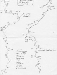
East Ledges Descent<br />
EL CAPITAN<br />
wild white dikes<br />
on black wall<br />
STEEP<br />
cross drainage, move<br />
down 40', then exit<br />
to shoulder<br />
WALL<br />
edge<br />
A<br />
4th<br />
150'<br />
A, B<br />
4th<br />
B<br />
135'<br />
100'<br />
B<br />
90'<br />
B<br />
120'<br />
or 5.5<br />
C<br />
155'<br />
C<br />
5.6 East<br />
Ledges route<br />
165' 100'<br />
200'<br />
165'<br />
A, B<br />
C<br />
Area overview<br />
55'<br />
150'<br />
Complete Yosemite Valley overview on pages 36–37<br />
to Yosemite Falls Trail<br />
and Camp 4<br />
B<br />
100'<br />
5.2<br />
to Tamarack Flat<br />
3rd<br />
Southwest<br />
Face<br />
El Capitan<br />
Southeast<br />
Face<br />
East Ledges<br />
descent<br />
Zodiac talus<br />
approach<br />
raps<br />
enlarged<br />
at right<br />
Manure Pile Buttress<br />
parking<br />
When trail meets<br />
drainage, cut across<br />
to trees and follow trail<br />
to Manure Pile buttress<br />
parking lot<br />
drainage<br />
standard<br />
approach<br />
one way<br />
El Capitan<br />
Meadow<br />
path<br />
to falls<br />
Cathedral Rocks<br />
FOR CURRENT ROUTE INFORMATION, VISIT SUPERTOPO.COM