Create successful ePaper yourself
Turn your PDF publications into a flip-book with our unique Google optimized e-Paper software.
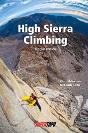
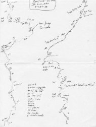
Yosemite Valley<br />
COPYRIGHT © 2000 SUPERTOPO LLC. ALL RIGHTS RESERVED. DUPLICATION PROHIBITED.<br />
Legend<br />
Road<br />
Bike path<br />
Park service trail<br />
Climber approach<br />
or descent trail<br />
Parking area<br />
to Hwy 120,<br />
west entrance,<br />
Hwy 140<br />
to south<br />
entrance,<br />
Hwy 41<br />
one way<br />
Bridalveil Fall<br />
parking<br />
one way<br />
to Tamarack Flat<br />
Southwest<br />
Face<br />
path<br />
to falls<br />
chimney<br />
descent<br />
Leaning Tower<br />
standard<br />
approach<br />
El Capitan<br />
Meadow<br />
Cathedral Rocks<br />
El Capitan<br />
Southeast<br />
Face<br />
to Yosemite Falls Trail<br />
and Camp 4<br />
East Ledges<br />
descent<br />
Zodiac talus<br />
approach<br />
raps<br />
Manure Pile Buttress<br />
parking<br />
one way<br />
Merced<br />
River<br />
Camp 4<br />
N<br />
one way<br />
Yosemite<br />
Lodge<br />
Continued on<br />
next page