GEOTOUR & IRSE 2012.pdf - Fakulta BERG - TUKE
GEOTOUR & IRSE 2012.pdf - Fakulta BERG - TUKE
GEOTOUR & IRSE 2012.pdf - Fakulta BERG - TUKE

You also want an ePaper? Increase the reach of your titles
YUMPU automatically turns print PDFs into web optimized ePapers that Google loves.
<strong>GEOTOUR</strong> & <strong>IRSE</strong> 2012<br />
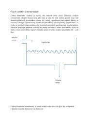
Fig. 4 Delius Pavilion<br />
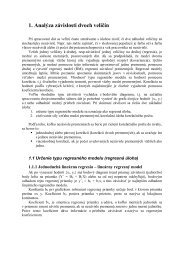
Fig. 5 The resulting model the chapel, Source: [6]<br />
development of information technology has become part of 3D navigation for tourists. Very<br />
popular are virtual tours towns, castles, nature trails eventually inaccessible underground<br />
spaces, caves and etc. When using a presentation created spatial model through the Internet so<br />
tourists have the possibility to explore and prepare for their interest target. Similarly, hotels<br />
and restaurants can offer added value to their complex visualization, attractions, and views<br />
from the windows of the towers and the like. Attractive is also visiting a museums and<br />
exhibits. In historical research to create models taking into account the time factor and creates<br />
a model object or a country allowing study the historical development and change.<br />
CONCLUSION<br />
The issue of spatial models is considerably extensive and time consumption. In the the<br />
primary phase, it is necessary to obtain data about the object, where are to use the best<br />
methods of surveying whether digital photogrammetry or laser scanning. Applicable methods<br />
are much more and selection is largely subjective. The subsequent processing of the measured<br />
data and the creation of the model is usually very time consumption. Creating detail requires<br />
precision work and quality software. However, use of the created models is widespread in<br />
various fields of human activity, even of science and research.<br />
71