Geological Survey Program
Geological Survey Program
Geological Survey Program

You also want an ePaper? Increase the reach of your titles
YUMPU automatically turns print PDFs into web optimized ePapers that Google loves.
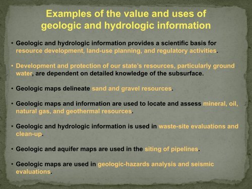
Examples of the value and uses of<br />
geologic and hydrologic information<br />
• Geologic and hydrologic information provides a scientific basis for<br />
resource development, land-use planning, and regulatory activities.<br />
• Development and protection of our state’s resources, particularly ground<br />
water, are dependent on detailed knowledge of the subsurface.<br />
• Geologic maps delineate sand and gravel resources.<br />
• Geologic maps and information are used to locate and assess mineral, oil,<br />
natural gas, and geothermal resources.<br />
• Geologic and hydrologic information is used in waste-site evaluations and<br />
clean-up.<br />
• Geologic and aquifer maps are used in the siting of pipelines.<br />
• Geologic maps are used in geologic-hazards analysis and seismic<br />
evaluations.