brochure laser scanner copertina ENGLISH - Geotec SpA
brochure laser scanner copertina ENGLISH - Geotec SpA
brochure laser scanner copertina ENGLISH - Geotec SpA

Create successful ePaper yourself
Turn your PDF publications into a flip-book with our unique Google optimized e-Paper software.
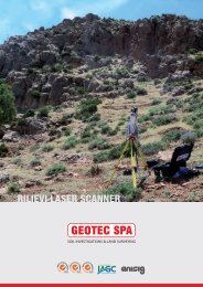
3D LASER SCANNING<br />
ISO 14001<br />
OHSAS 18001<br />
ISO 9001:2000
3D Laser Scanning Surveys<br />
<strong>Geotec</strong> S.p.A.<br />
<strong>Geotec</strong> <strong>SpA</strong> can provide a professional 3D<br />
Laser scanning service<br />
Laser scanning creates an organised, highly accurate, digital representation of<br />
a subject quickly and efficiently. This new and emerging technology allows for<br />
the 3D digital acquisition of objects in the form of geo-referenced and geometrically<br />
correct point clouds. These clouds can then be reconstructed to give<br />
them a surface, and rendered with colour or images added to give a realistic<br />
texture to the 3D model. The accuracy of the <strong>laser</strong> together with the precision<br />
of high resolution images makes <strong>laser</strong> scanning surveys realistic and complete.<br />
The uses of Laser scanning technology are endless. Real world environments,<br />
people, equipment and items are captured in 3D exactly as they are. 3D <strong>laser</strong><br />
scanning technology can provide a detailed spatial representation of particularly<br />
complex objects, in unreachable and inaccessible survey locations.<br />
Particularly useful in the survey of cultural artefacts and historical sites and<br />
buildings, and in situations which would be otherwise difficult to research.<br />
The raw point cloud data acquired can be used:<br />
To automatically obtain plane sections and generate plans and section<br />
views as well as axonometric projections and 3D models;<br />
To produce high resolution Digital Terrain Models (DTM);<br />
To create orthophotos;<br />
To develop mathematical equations;<br />
To automatically identify surfaces (meshes), volume, contours, break lines<br />
and aspect ratio;<br />
For environmental, structural, infrastructural and archaeological monitoring;<br />
To easily integrate the surveys with topography and photogrammetry;<br />
To navigate virtually;<br />
To simulate possible solutions, changes and alterations to brightness and colour;<br />
For conservation and deterioration analysis.
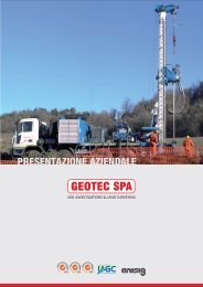
3D Laser Scanning Surveys <strong>Geotec</strong> S.p.A.<br />
With regard to Laser scanning surveys<br />
<strong>Geotec</strong> S.p.A. can also provide:<br />
All types of topographical surveys<br />
Temporary traffic management when scanning on roads<br />
Made to measure tools by CNC turning experts from our workshop and<br />
personalised preparation of the Laser scanning support vehicle according<br />
to specific needs<br />
Preparation of survey locations (excavator, chain saw etc.) that would<br />
otherwise be inaccessible<br />
3D scanning services are applied to:<br />
Civil engineering<br />
Environmental engineering<br />
Architecture<br />
Heritage sites and archaeology<br />
<strong>Geotec</strong> S.p.A. can offer:<br />
Planning, analysis and development of the Laser scanning survey<br />
Topographical land surveys using GPS or electro-optical instrumentation<br />
Processing and rendering of scan data according to client’s needs<br />
Research and experimentation for innovative Laser scanning applications<br />
Laser scanning experience<br />
Laser scanning services were provided to ANAS S.p.A. – The Italian National<br />
Road works Company – in various projects in central Italy and the Abruzzo<br />
region. Structures and infrastructures with no previous designs or plans were<br />
scanned and subsequently reconstructed. Approximately 200 surveys were<br />
carried out of buildings, viaducts and bridges.<br />
<strong>Geotec</strong> S.p.A. has also provided Laser scanning services to another Italian<br />
company “Società italiana per Condotte d’Acqua S.p.A.”, in a project regarding<br />
the new Tlelat – Tlemcen railway line in Algeria. A high resolution 3D digital<br />
model was created of the slopes where the railway line will pass.<br />
The University of Rome “La Sapienza” also made use of <strong>Geotec</strong> <strong>SpA</strong>’s Laser<br />
scanning services for the Farnesian bastion of “Domus Tiberiana”, a very<br />
important Roman landmark. Sections, plans and detailed orthophotos were<br />
produced and presented as part of a study regarding safety improvements for<br />
the preservation of the landmark.<br />
<strong>Geotec</strong> S.p.A. is also capable of scanning objects and creating digital models.<br />
Through the use of 3D printers scale models are reproduced.
3D Laser Scanning Surveys <strong>Geotec</strong> S.p.A.<br />
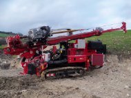
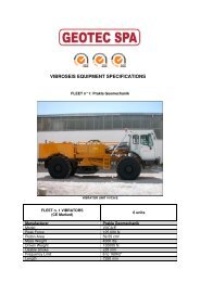
Our scanning equipment and software includes:<br />
Riegl LMS Z390i Terrestrial Laser Scanner<br />
Riegl VZ400 Terrestrial Laser Scanner<br />
Zoller+Fröhlich Z+F IMAGER® 5010 Terrestrial Laser Scanner<br />
External calibrated Nikon D90 Camera<br />
External calibrated Nikon D700 Camera<br />
RIEGL_VZ400 Laser <strong>scanner</strong><br />
SCHNEIDER KREUZNACH CINECON 1.8/4.8-0902 Industrial<br />
Camera<br />
Leica TPS 1200 Total Station<br />
Leica Receiver GNSS - GS 15<br />
Leica Viva CS 15 Controller<br />
Z+F MAGER 5010 Laser <strong>scanner</strong><br />
TRIMBLE 5601 DR 200 Total Station<br />
Riegl RiSCAN PRO Software<br />
Z+F Laser Control Software<br />
Point cloud Display Software<br />
Point tools Software<br />
RIEGL LMS-Z390 Laser <strong>scanner</strong><br />
Traversetolo (Parma)<br />
Tirana (Albania)<br />
Campobasso<br />
S. Caterina Villarmosa (Caltanissetta)<br />
Administrative headquarters Operational site Albanian branch Sicilian branch<br />
Via Barbato, 20 - 86100 Campobasso ITALY - Tel. +39 0874 699077 Fax +39 0874 699218 info@geotecspa.com - www.geotecspa.com