Kids Running - Adirondack Sports & Fitness
Kids Running - Adirondack Sports & Fitness
Kids Running - Adirondack Sports & Fitness

You also want an ePaper? Increase the reach of your titles
YUMPU automatically turns print PDFs into web optimized ePapers that Google loves.
10 <strong>Adirondack</strong> <strong>Sports</strong> & <strong>Fitness</strong><br />
A s<br />
the last glacier began to recede<br />
from the <strong>Adirondack</strong>s, swift rivers<br />
of meltwater coursed through the<br />
fissures and fractures in the ice. These<br />
rivers carried many tons of sediment, and<br />
when they dried up they deposited this<br />
sediment in long, snakelike mounds<br />
across the landscape. These mounds,<br />
which are distinguished by their narrow<br />
ridgelines, are called eskers, or sometimes<br />
“hogsbacks.” They are common features<br />
all across glaciated North America.<br />
A part of the longest esker in the northern<br />
<strong>Adirondack</strong> region borders the west<br />
side of Long and Black ponds at the base<br />
of Jenkins Mountain. These two ponds,<br />
which are managed as part of the<br />
<strong>Adirondack</strong> Park Visitor Interpretive<br />
Center (VIC) campus at Paul Smiths, are<br />
scenic gems encircled by excellent hiking<br />
trails. They provide a somewhat more<br />
rugged <strong>Adirondack</strong> experience than the<br />
well-groomed interpretive trails nearer<br />
the main complex, and they rarely lead<br />
the hiker out of view of the ponds.<br />
They are also the beginning of a 4.1mile<br />
hike to Jenkins Mountain, with its<br />
gradual 880-foot climb. Jenkins’ partially<br />
wooded summit offers a fine view to the<br />
south, and this route that takes you there<br />
by way of the two ponds and the esker is<br />
one of the finest in the northern<br />
<strong>Adirondack</strong>s. All of these trails are very<br />
well suited for winter use, although many<br />
cross country skiers and snowshoers may<br />
prefer to travel across the open ice, where<br />
the traveling is easier.<br />
How to Get There<br />
The main entrance to the VIC is located<br />
just north of Paul Smiths on NY Route<br />
30, and the facility is open all year long,<br />
seven days a week. However, the Black<br />
Pond trailhead is located on the outer edge<br />
of the VIC campus. To find it, drive west<br />
from NY Route 30 in Paul Smiths for 2.5<br />
miles on Keese Mills Road. The St. Regis<br />
Presbyterian Church is on the south side of<br />
the road, and opposite it to the north, just<br />
across a stream, is a parking area that can<br />
accommodate eight to ten cars.<br />
The Trail<br />
The main orange-marked trail takes<br />
you along the west bank of the outlet for<br />
0.2-mile to Black Pond. There are three<br />
lean-tos on the two ponds. They were built<br />
by forestry management students and are<br />
currently open to the public, but only for<br />
daytime use. Camping is not allowed anywhere<br />
on this property. The first lean-to is<br />
a five-minute trek from the road, at the<br />
southwest corner of Black Pond.<br />
The narrow trail is pinched between<br />
the steep slopes of the esker to your left<br />
PERCEPTION • PLATYPUS • PRIMUS • PUR • STOLQUIST • SWIFT • TEVA • WERNER • WILDERNESS • YAKIMA<br />
CROSS COUNTRY SKIING & SNOWSHOEING<br />
and the pond to your right. Rarely is the<br />
view impeded. You pass a canoe landing<br />
at 0.8-mile, and then leave the pond to<br />
reach the outlet stream of Long Pond. At<br />
one-mile, you reach a marked intersection<br />
where the orange trail bears right to<br />
loop around the east side of Black Pond<br />
back to Keese Mills Road. To reach Long<br />
Pond and Jenkins Mountain, follow the<br />
red-marked trail straight ahead.<br />
ADK BOOKS • AQUA BOUND • BELL CANOES • BOMBER GEAR • BOREAL DESIGN • CHACO • CURRENT DESIGNS<br />
It’s Never Too Soon<br />
To Gear Up For A Great Time.<br />
Kayaks, Canoes & Paddling Accessories,<br />
Outdoor Clothing, Books,<br />
Camping Gear and More.<br />
Sales, Lessons, Rentals, Tours.<br />
518.644.9366<br />
www.lakegeorgekayak.com<br />
Paddle Shop: Main Street<br />
Bolton Landing, NY 12814 Not Just Inventory. Answers.<br />
Service. Selection. Knowledge. Satisfaction. Your Resource for In-Stock Composite Boats.<br />
KELTY • KOKATAT • LIFE IS GOOD • LOTUS • MARMOT • MITCHELL • MSR • NECKY • NRS • OR • PATAGONIA<br />
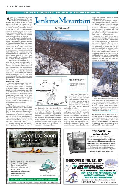
JenkinsMountain<br />
0 1<br />
Scale in Miles<br />
MAP BY<br />
JEFF CARON<br />
Jenkins<br />
Mtn. ▲<br />
Keese Mill<br />
Black<br />
Pond<br />
by Bill Ingersoll<br />
Long<br />
Pond<br />
Keese Mills<br />
DAGGER • EDDYLINE • EXTRASPORT • FEATHERCRAFT • GAIA • IMPEX • KATADYNE • KAVU • KEEN<br />
Road<br />
To NY Rt. 30<br />
& Paul Smiths<br />
� MCKENZIE RANGE FROM<br />
JENKINS MOUNTAIN.<br />
� WHITEFACE FROM JENKINS<br />
MOUNTAIN.<br />
PHOTOS BY BILL INGERSOLL<br />
The Beaver Lodge Lean-To is<br />
located near the north end of<br />
Long Pond. The trail passes the<br />
pond and its lean-to and continues<br />
north. You pass beside an<br />
open wetland and into a balsam<br />
forest to reach the intersection<br />
with the Jenkins Mountain<br />
road/trail at 1.5 miles.<br />
Bear left on this blue-marked trail,<br />
heading northwest. Shortly beyond, the<br />
road bends sharply south. The trail narrows<br />
and winds along the top of the series<br />
of eskers, with one huge beaver meadow<br />
below the steep slopes to your right. Over<br />
the beaver pond you have a lovely view<br />
north to the rock slopes of Jenkins’ eastern<br />
summit. The travel along the eskers con-<br />
tinues for another half-mile before<br />
angling sharply right.<br />
At 2.5 miles, the trail begins a long traverse<br />
along the foot of Jenkins’ steep southern<br />
slopes. You have wonderful views up<br />
to the rock ledges that front this part of the<br />
mountain. Notice how tall, straight, yet<br />
small in diameter are the trees that grace<br />
the slopes. In one place there is a stand of<br />
paper birch – sure signs of an old forest fire<br />
– but most of the trees are maples.<br />
Just short of 3.5 miles, the trail makes<br />
a sharp turn to the right and climbs more<br />
steeply to a turn back west. The grade then<br />
moderates again as the trail approaches<br />
the summit. Gradually, the trail curves<br />
east to head up the northwest slopes. As<br />
the slopes become steeper, the trail zigzags<br />
back and forth to keep the grades<br />
gentle, thus making it possible that determined<br />
cross country skiers, capable of<br />
negotiating the few truly steep sections,<br />
could make their way up this mountain.<br />
Just below the western summit, the trail<br />
zags back left, west to the rock knob that<br />
tops the far western edge.<br />
From the knob you can see Follensby Jr.<br />
Pond to the north, St. Regis Mountain just<br />
west of south, the McKenzie Range, and<br />
the High Peaks from the Sewards around to<br />
Whiteface. The return trip, retracing your<br />
steps, takes little more than two hours, but<br />
pause frequently to discover what you may<br />
have missed on the trip up.<br />
Bill Ingersoll lives in Barneveld. He is<br />
revising Barbara McMartin’s Discover<br />
series and is co-author of several books.<br />
For more information about this<br />
region consult Discover the Northern<br />
<strong>Adirondack</strong>s (Lake View Press); the third<br />
edition will be in stores this month.<br />
Discover Inlet, NY<br />
And all the beauty that surrounds us<br />
Free Cross-country Ski & Snowshoe<br />
Trails. Free Ice Skating Rink<br />
with Warming Hut. Free Sledding Hill.<br />
Great Food , Cozy Accommod ations,<br />
Groomed Snowmobile Tra ils,<br />
Fun for the W hole Family<br />
For maps & more: Inlet Area Information Office<br />
1-866-GO INLET www.inletny.com