Leica Viva GNSS GS08plus receiver Datasheet - GeoWILD
Leica Viva GNSS GS08plus receiver Datasheet - GeoWILD
Leica Viva GNSS GS08plus receiver Datasheet - GeoWILD

You also want an ePaper? Increase the reach of your titles
YUMPU automatically turns print PDFs into web optimized ePapers that Google loves.
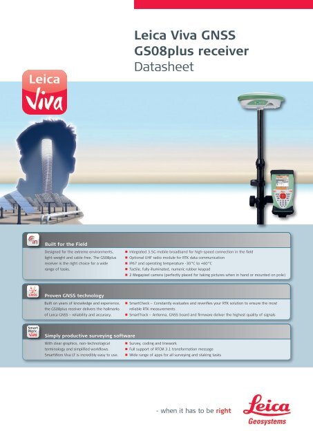
<strong>Leica</strong> <strong>Viva</strong> <strong>GNSS</strong><br />
<strong>GS08plus</strong> <strong>receiver</strong><br />
<strong>Datasheet</strong><br />
Built for the Field<br />
Designed for the extreme environments,<br />
light-weight and cable-free. The <strong>GS08plus</strong><br />
<strong>receiver</strong> is the right choice for a wide<br />
range of tasks.<br />
• n Integrated 3.5G mobile broadband for high-speed connection in the field<br />
• n Optional UHF radio module for RTK data communication<br />
• n IP67 and operating temperature -30 °C to +60 °C<br />
• n Tactile, fully illuminated, numeric rubber keypad<br />
• n 2 Megapixel camera (perfectly placed for taking pictures when in hand or mounted on pole)<br />
Proven <strong>GNSS</strong> technology<br />
Built on years of knowledge and experience,<br />
the <strong>GS08plus</strong> <strong>receiver</strong> delivers the hallmarks<br />
of <strong>Leica</strong> <strong>GNSS</strong> – reliability and accuracy.<br />
• n SmartCheck – Constantly evaluates and reverifies your RTK solution to ensure the most<br />
reliable RTK measurements<br />
• n SmartTrack – Antenna, <strong>GNSS</strong> board and firmware deliver the highest quality of signals<br />
Smart<br />
Worx<br />
Simply productive surveying software<br />
With clear graphics, non-technological<br />
terminology and simplified workflows.<br />
SmartWorx <strong>Viva</strong> LT is incredibly easy to use.<br />
• n Survey, coding and linework<br />
• n Full support of RTCM 3.1 transformation message<br />
• n Wide range of apps for all surveying and staking tasks
Technical Specifications<br />
<strong>Leica</strong> <strong>GS08plus</strong> SmartAntenna<br />
CS10 Field Controller<br />
Operating System Microsoft Windows CE 6.0<br />
Processor<br />
Freescale iMX31 533 MHz ARM Core with 512 MB DDR SDRAM<br />
Display<br />
8.9 cm (3.5") 640 x 480 pixel (VGA) colour touch screen, sunlight-readable, backlight<br />
Keyboard<br />
26 keys, numeric keypad, fully illuminated<br />
Data storage<br />
1 GB internal flash, SD-card slot, CF-card Type I / II slot, USB connector port<br />
Audio<br />
Integrated sealed speaker and microphone<br />
Camera<br />
Integrated 2 Megapixel fixed focus camera<br />
Wireless connectivity<br />
Bluetooth ® 2.0 Class 2, Wireless LAN 802.11b/g (option), high speed broadband 3.5G GSM & UMTS (option),<br />
UHF radio module (option)<br />
Application Software<br />
<strong>Leica</strong> SmartWorx <strong>Viva</strong> LT<br />
Standard Software<br />
Internet Explorer Mobile, File Explorer, Word Mobile, Windows Media Player, Camera Software, Online Help<br />
<strong>GS08plus</strong> SmartAntenna<br />
<strong>GNSS</strong> technology<br />
<strong>Leica</strong> SmartTrack technology:<br />
• Advanced measurement engine<br />
• Jamming resistant measurements<br />
• High precision pulse aperture multipath correlator for pseudorange measurements<br />
No. of channels<br />
120 channels<br />
Satellite signals tracking<br />
GPS: L1, L2, L2C (C/A, P, C Code)<br />
GLONASS: L1, L2 (C/A, P narrow Code)<br />
SBAS: WAAS, EGNOS, GAGAN, MSAS<br />
User interface<br />
On / Off key. Satellite tracking, Bluetooth ® communication & battery power LED status indicators<br />
Communication ports<br />
Bluetooth ® 2.0 Class 2, 8-pin Lemo combined USB / power port<br />
Field controller connection<br />
By Bluetooth ® or with GEV237 Lemo plug cable<br />
Accuracy and reliability 1<br />
RTK Static mode<br />
Horizontal: 5 mm + 0.5 ppm (rms)<br />
Vertical: 10 mm + 0.5 ppm (rms)<br />
Compliant to ISO 17123-8 standard<br />
RTK Moving mode<br />
Horizontal: 10 mm + 1 ppm (rms)<br />
Vertical: 20 mm + 1 ppm (rms)<br />
Post Processing static mode<br />
Horizontal: 3 mm + 0.5 ppm (rms)<br />
Vertical: 6 mm + 0.5 ppm (rms)<br />
Reliability<br />
Better than 99,9 % using <strong>Leica</strong> SmartCheck technology<br />
Time for initalisation Typically 6 sec 2<br />
Real time kinematic specifications<br />
RTK data formats<br />
<strong>Leica</strong> proprietary formats (<strong>Leica</strong>, <strong>Leica</strong> 4G), CMR+, RTCM2.x, RTCM3.x, full support of RTCM 3.1 transformation message<br />
Position update rate<br />
1 Hz standard, Optional 5 Hz (0.2 sec)<br />
Network positioning<br />
VRS, FKP, iMAX, MAX, Nearest Station<br />
RTK base station (option)<br />
Transmit RTCM3 RTK data at 1 Hz (1 sec)<br />
Physical specifications<br />
Weight of pole setup<br />
2.60 kg for complete rover setup, including batteries and telescopic pole<br />
Temperature, operating -30°C to +60°C (-22°F to +140°F), <strong>GS08plus</strong> only: -40°C to +65°C (-40°F to +149°F) 3<br />
Temperature, storage -40°C to +80°C (-40°F to +176°F) 3<br />
Humidity 100 % 4<br />
Sealed against water, sand and dust IP67: Temporary submersion into water (max. depth 1m)<br />
Protected against blowing rain and dust<br />
Vibration<br />
Withstands vibrations in compliance with ISO9022-36-05<br />
Drops<br />
Withstands 1 m drop onto hard surface<br />
Topple over<br />
Withstands topple over from a 2 m survey pole onto hard surface<br />
Functional shock<br />
No loss of lock to satellite signals when used on a pole setup and submitted to pole bumps up to 100 mm<br />
Power management<br />
Supply Voltage<br />
Nominal 12V DC, Range 10.5 – 28V DC<br />
Internal power supply<br />
Operation time<br />
Battery charging<br />
Removable & rechargable Li-Ion battery, 2.6 Ah / 7.4 V (1x in CS10 and 1x in <strong>GS08plus</strong>)<br />
10 hours <strong>GNSS</strong> only, 7 hours <strong>GNSS</strong> RTK 5<br />
2 hours with GKL211 charger or with GEV235 field controller power supply<br />
1<br />
Measurement precision, accuracy and reliability are dependent upon various factors including number of satellites, geometry,<br />
obstructions, observation time, ephemeris accuracy, ionospheric conditions, multipath etc. Figures quoted assume normal to<br />
favorable conditions. GPS and GLONASS can increase performance and accuracy by up to 30% relative to GPS only.<br />
2<br />
May vary due to atmospheric conditions, multipath, obstructions, signal geometry and number of tracked signals.<br />
3<br />
Compliance with ISO9022-10-08, ISO9022-11-special and MIL-STD 810G Method 502.5-II, MIL-STD 810G Method 501.5-II,<br />
MIL-STD 810G Method 502.5-I, MIL-STD 810G Method 501.5-I<br />
4<br />
Compliance with ISO9022-13-06, ISO9022-12-04 and MIL-STD 810G Method 507.5-I<br />
5<br />
May vary with temperature, battery age and power of RTK of data link device.<br />
Total Quality Management –<br />
our commitment to total<br />
customer satisfaction.<br />
The Bluetooth ® word mark and<br />
logos are owned by Bluetooth<br />
SIG, Inc. and any use of such<br />
marks by <strong>Leica</strong> Geosystems AG<br />
is under license.<br />
Illustrations, descriptions and technical data are not binding. All rights reserved. Printed in Switzerland –<br />
Copyright <strong>Leica</strong> Geosystems AG, Heerbrugg, Switzerland, 2012. 798713en – XI.12 – galledia<br />
Windows CE, Internet Explorer Mobile,<br />
File Explorer, Word Mobile & Windows<br />
Media Player are either registered<br />
trademarks or trademarks of<br />
Microsoft Corporation in the united<br />
States and / or other countries.<br />
Other trademark and trade<br />
names are those of their<br />
respective owners.<br />
<strong>Leica</strong> Geosystems AG<br />
Heerbrugg, Switzerland<br />
www.leica-geosystems.com