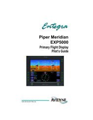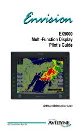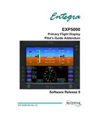
Avidyne's FlightMax EX5000 brings affordable, large- format ...
Avidyne's FlightMax EX5000 brings affordable, large- format ...
Avidyne's FlightMax EX5000 brings affordable, large- format ...

You also want an ePaper? Increase the reach of your titles
YUMPU automatically turns print PDFs into web optimized ePapers that Google loves.
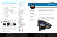
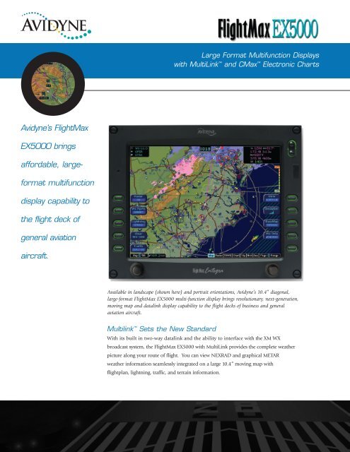
Large Format Multifunction Displays<br />
with MultiLink and CMax Electronic Charts<br />
Avidyne’s <strong>FlightMax</strong><br />
<strong>EX5000</strong> <strong>brings</strong><br />
<strong>affordable</strong>, <strong>large</strong><strong>format</strong><br />
multifunction<br />
display capability to<br />
the flight deck of<br />
general aviation<br />
aircraft.<br />
Available in landscape (shown here) and portrait orientations, Avidyne’s 10.4” diagonal,<br />
<strong>large</strong>-<strong>format</strong> <strong>FlightMax</strong> <strong>EX5000</strong> multi-function display <strong>brings</strong> revolutionary, next-generation,<br />
moving map and datalink display capability to the flight decks of business and general<br />
aviation aircraft.<br />
Multilink Sets the New Standard<br />
With its built in two-way datalink and the ability to interface with the XM WX<br />
broadcast system, the <strong>FlightMax</strong> <strong>EX5000</strong> with MultiLink provides the complete weather<br />
picture along your route of flight. You can view NEXRAD and graphical METAR<br />
weather in<strong>format</strong>ion seamlessly integrated on a <strong>large</strong> 10.4” moving map with<br />
flightplan, lightning, traffic, and terrain in<strong>format</strong>ion.
Multi-Function Display<br />
The Best Map Available<br />
Available in portrait and landscape<br />
configurations, the <strong>FlightMax</strong> <strong>EX5000</strong><br />
is the most advanced, yet easy-to-use<br />
<strong>large</strong>-<strong>format</strong> MFD available for general<br />
aviation aircraft. All special-use and<br />
class airspaces are color-keyed for added<br />
clarity, and can be displayed at the same<br />
time as NEXRAD or weather radar data<br />
for a more complete picture. Full<br />
overlay capability allows you to add<br />
or remove traffic, lightning, and radar,<br />
with 180-degree forward view and<br />
360-degree center view maps.<br />
The landscape <strong>FlightMax</strong> <strong>EX5000</strong> interfaces with the Bendix/King<br />
RDR 2000 radar which can be overlaid right on the map page or<br />
viewed on a dedicated radar page. Vertical Profile can also be viewed<br />
from the radar page for a more accurate picture of imminent weather.<br />
All The In<strong>format</strong>ion At A Glance<br />
The Trip Page provides in<strong>format</strong>ion about your route of flight<br />
including a list of all remaining waypoints in the active flightplan,<br />
with distances and times for each leg. Graphical METARs for all<br />
reporting airports are also listed, which can help you in determining<br />
an alternate airport in the event of inclement weather or an<br />
emergency situation. Textual METARs are also available for each<br />
reporting airport. <strong>FlightMax</strong> translates the METAR abbreviations<br />
into plain English for easy interpretation.<br />
The Easiest To Use<br />
The <strong>FlightMax</strong> <strong>EX5000</strong>’s user interface dramatically improves<br />
your ability to access and display critical flight data. This design<br />
philosophy keeps operation simple and consistent by allowing you<br />
to select and display what you need on a single easy-to-interpret<br />
integrated moving map. The <strong>FlightMax</strong> <strong>EX5000</strong> can also act as the<br />
on-board radar display, providing easy access to radar modes, tilt<br />
control, and bearing adjust.
With the <strong>FlightMax</strong> <strong>EX5000</strong>’s “map-centric”<br />
operation, you can display a moving map of your<br />
flight plan along with radar and datalink weather.<br />
And special-use airspace. And traffic. And terrain.<br />
And lightning. Without ever leaving the map page.<br />
It’s the only <strong>large</strong>-<strong>format</strong> display that provides the<br />
complete picture and it’s the easiest to use.<br />
CMax - Maximizing Your Approach<br />
Avidyne’s CMax Electronic Charts option offers a<br />
world-wide library of geo-referenced approach charts<br />
and airport diagrams, helping you manage and access<br />
critical flight in<strong>format</strong>ion and reducing the amount<br />
of paper required on board your aircraft.<br />
CMax Approach Charts allow <strong>FlightMax</strong>® customers<br />
to view approach charts and airport diagrams along<br />
with their aircraft’s position and flight plan for<br />
improved situational awareness during the most<br />
critical phases of flight.<br />
CMax automatically switches to the destination airport<br />
diagram when ground speed drops below 40kts and shows your<br />
aircraft’s position on the runway and taxiways.<br />
Utilizing Jeppesen’s trusted JeppView Electronic<br />
Airway Manual, CMax makes accessing an approach<br />
or viewing an airport diagram a breeze. At startup,<br />
your departure airport chart is automatically loaded<br />
for ease of orientation, especially at unfamiliar<br />
fields.<br />
Your destination airport diagram and the list of<br />
available approaches are automatically loaded at<br />
the time your flight plan is entered, and can be<br />
viewed easily using the Auto-fill capability, or you<br />
can easily select and view any approach at any<br />
airport in the database.<br />
CMax shows your position all along the approach for enhanced<br />
situational awareness and safety during the most critical phase of flight.
Specifications<br />
Applicable TSOs:<br />
• TSO C63c Airborne Weather Radar*<br />
• TSO C110a Airborne Passive<br />
Thunderstorm Detection<br />
• TSO C113 Airborne Multipurpose<br />
Electronic Display<br />
• TSO C147 Traffic Advisory System (TAS)<br />
Display:<br />
• 10.4” Diagonal, Color Active-Matrix<br />
LCD Sunlight readable<br />
• 800x600 pixels, 65,536 colors<br />
Physical Dimensions:<br />
• 8.5”H x 10.7”W x 4.62”D (landscape)<br />
• 10.7”H x 8.5”W x 4.6”D (portrait)<br />
Weight:<br />
• 6.75 lbs<br />
Power Requirements:<br />
• Max 5.0A @ 28VDC<br />
Environmental:<br />
• DO 160D to 50,000 ft.<br />
• -20C to +55C Operating<br />
• +70C Short Term<br />
Cooling:<br />
• Internal forced air cooling provided<br />
Warranty:<br />
• 2 years parts & labor included<br />
• Extended warranty service available<br />
Functionality<br />
MultiLink Interface<br />
• Heads Up Technologies XMD-076 using<br />
XM WX Satellite Weather Service<br />
• Internal datalink transceiver using<br />
<strong>FlightMax</strong> Datalink Weather Service &<br />
ORBCOMM satellite network.<br />
Vector-Graphic Moving Map<br />
• Americas Jeppesen NavData<br />
• International Jeppesen NavData - Optional<br />
• Portable Dataloader - Optional<br />
GPS/FMS Interface<br />
• RS-232<br />
• ARINC 429 GAMA Graphics<br />
Approach Charts<br />
• CMax - Jeppesen Electronic<br />
Airway Manual Charts - Optional<br />
Traffic Interfaces<br />
• Avidyne TAS 600 Series<br />
• Ryan TCAD 9900BX<br />
• Honeywell KTA870/KMH880 TAS/IHAS<br />
• L3 Skywatch/Skywatch HP<br />
• Garmin GTX 330 TIS Transponder<br />
Terrain Awareness<br />
• Color-Contoured Terrain Base Map Built in<br />
- Americas Terrain & US Obstacle Data<br />
- International Terrain Data - Optional<br />
• EGPWS/TAWS Interface - Optional<br />
- Honeywell KMH880 IHAS<br />
- Honeywell KGP 560 G.A.<br />
Lightning Sensor Interface<br />
• L3 WX 500 Stormscope<br />
Heading Interface<br />
• ARINC 429<br />
Radar Interface<br />
• Bendix/King RDR 2000 (landscape only)<br />
The <strong>EX5000</strong>'s MultiLink capability delivers<br />
NEXRAD, METAR, AIRMET/SIGMET, and<br />
TFRs in near-real time. In addition, you will<br />
also have access to datalinked Lightning, TAFs,<br />
Winds Aloft, Freezing Levels, NEXRAD Cell<br />
Movement, and Hail Alerts.<br />
*<br />
The <strong>FlightMax</strong> <strong>EX5000</strong> presents<br />
navigation, radar*, datalink<br />
weather, lightning, traffic,<br />
and terrain data in an easy-tointerpret<br />
<strong>format</strong>, dramatically<br />
improving situational awareness<br />
and enhancing safety through all<br />
phases of flight.<br />
* Radar only available on landscape.<br />
Avionics installations require special skills and test equipment. Avidyne’s limited<br />
warranty is valid only for equipment installed by an authorized Avidyne Service<br />
Center. Avidyne reserves the right to make changes to product specifications and<br />
design features without notice.<br />
All other trademarks are the property of their respective companies.<br />
Avidyne Corporation<br />
55 Old Bedford Rd. • Lincoln, MA 01773<br />
Ph: 781-402-7400 • Toll Free: 800-AVIDYNE<br />
Fax: 781-402-7599<br />
www.avidyne.com • info@avidyne.com<br />
©2006 Avidyne Corporation All Rights Reserved.<br />
AV628 3/06 5000