AABSYS GEOSPATIAL FACILITIES â GIS - AABSyS IT
AABSYS GEOSPATIAL FACILITIES â GIS - AABSyS IT
AABSYS GEOSPATIAL FACILITIES â GIS - AABSyS IT

You also want an ePaper? Increase the reach of your titles
YUMPU automatically turns print PDFs into web optimized ePapers that Google loves.
Tel: +91 (674) 662 1009 E-mail: info@aabsys.com Web: http://www.aabsys.com<br />
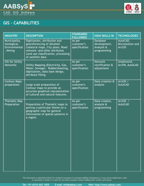
<strong>GIS</strong> – CAPABIL<strong>IT</strong>IES<br />
INDUSTRY<br />
Municipality,<br />
Geological,<br />
Environmental<br />
, Mining<br />
DESCRIPTION<br />
Digitization, attribution and<br />
georeferencing of detailed<br />
cadastral maps, City plans, Road<br />
network, and other attributes<br />
Land use classification, processing<br />
of satellite data<br />
STANDARDS<br />
FOLLOWED<br />
As per<br />
customer’s<br />
specification<br />
HIGH SKILLS IN<br />
Database<br />
development,<br />
Analysis &<br />
programming<br />
TECHNOLOGIES<br />
AutoCAD,<br />
Microstation and<br />
Arc<strong>GIS</strong><br />
<strong>GIS</strong> for Utility<br />
Networks<br />
Utility Mapping (Electricity, Gas,<br />
Water, Sewage) - Rubbersheeting,<br />
digitization, data base design,<br />
attribute filling<br />
As per<br />
customer’s<br />
specification<br />
Network<br />
rectification &<br />
adjustment<br />
Smallworld,<br />
ArcFM, AutoCAD<br />
Contour Maps<br />
preparation<br />
Large scale preparation of<br />
Contour maps to provide an<br />
accurate graphical representation<br />
of cultural and natural features.<br />
As per<br />
customer's<br />
specification<br />
Data creation &<br />
analysis<br />
Arc<strong>GIS</strong> /<br />
AutoCAD<br />
Thematic Map<br />
Preparation<br />
Preparation of Thematic maps to<br />
portray a particular theme on a<br />
geographic map for general<br />
information of spatial patterns in<br />
a region.<br />
As per<br />
customer’s<br />
specification<br />
Data creaton,<br />
analysis &<br />
programming<br />
Arc<strong>GIS</strong> /<br />
AutoCAD<br />
This document is submitted solely for recipient's purposes to evaluate <strong>AABSyS</strong> Competency. It may not be duplicated, used,<br />
or disclosed in whole or in part for any other purpose without <strong>AABSyS</strong> prior written permission.