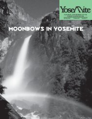
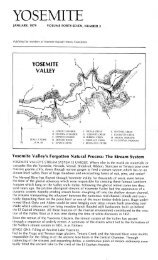
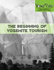
YA summer '01 - Yosemite Online
YA summer '01 - Yosemite Online
YA summer '01 - Yosemite Online

Create successful ePaper yourself
Turn your PDF publications into a flip-book with our unique Google optimized e-Paper software.
atively narrow V-shaped valley, it can be shown that the<br />
ice would have a maximum velocity gradient some distance<br />
up the sides of the valley walls (Figure 4). 2 At this<br />
location the shear stress, a measure of erosive force,<br />
would be greatest. Thus the valley sides would be preferentially<br />
eroded there, and the V-shaped profile gradually<br />
changed to a U-shaped profile (Figure 5).<br />
Prominent planar fractures, known as joints, are common<br />
in granite and can exert significant control over glacial<br />
excavation, so not all glaciated valleys in Sierran<br />
granite will acquire a distinct U-shaped profile. If the<br />
rock has prominent joints, known as “sheet joints,” subparallel<br />
to the sides of a V-shaped canyon, the glacier will<br />
simply pluck off the rock sheet-by-sheet, and so maintain<br />
a modified, but still V-shaped, canyon profile.<br />
Examples are the Grand Canyon of the Tuolumne River<br />
above Hetch Hetchy Valley (which contained the largest<br />
and most active valley glacier in the Sierra Nevada), the<br />
Merced Gorge between <strong>Yosemite</strong> Valley and El Portal,<br />
and Tenaya Canyon, all of which have retained roughly<br />
V-shaped cross-profiles. If joints trend across a canyon,<br />
or are otherwise irregular, glacial excavation will produce<br />
a more prominently U-shaped profile, such as in<br />
<strong>Yosemite</strong> Valley or Hetch Hetchy.<br />
Once a glacier has sculpted a U-shaped bed, it can<br />
continue to excavate its bed to any depth. Where much<br />
ice has to flow through a narrower segment of the valley,<br />
or at the point of convergence of two glaciers, the ice<br />
must flow more rapidly through the slot to accommodate<br />
the combined volume of ice. Rapid flow tends to excavate<br />
deeply, and the glacier bed can be locally deepened to create<br />
a basin that later fills with water to form a lake after<br />
the ice melts. The deep bedrock basin in upper <strong>Yosemite</strong><br />
ValleymayhavebeencarvedbyicefromtheMercedand<br />
Tenaya glaciers that converged there during the extensive<br />
Sherwin glaciation. During the millennia following<br />
retreat of the Sherwin ice, that basin was mostly filled, in<br />
part by entrained material released by the melting ice, in<br />
part by stream-transported sediment and, in part by<br />
debris weathered and spalled from the valley walls.<br />
The processes described above are best exemplified by<br />
the development of such long, straight, U-shaped valleys<br />
as those displayed by Stubblefield, Matterhorn, and<br />
Virginia Canyons in northern <strong>Yosemite</strong> National Park,<br />
and Lyell Canyon above Tuolumne Meadows (Figure 6).<br />
These valleys are high enough in the range to have<br />
undergone multiple full-scale glaciations, including the<br />
last one, the Tioga glaciation, which peaked about 20,000<br />
years ago.<br />
In many ways, Hetch Hetchy Valley, on the Tuolumne<br />
River some 15 miles north of <strong>Yosemite</strong> Valley, is a<br />
“fresher” example of a glacial valley than <strong>Yosemite</strong>. Even<br />
during the most recent Tioga-age glaciation, the<br />
Tuolumne River canyon was filled to its rim with ice. In<br />
Figure 3. Diagram showing<br />
variation in steepness of<br />
ice-surface slope on opposite<br />
sides of bends in a valley<br />
glacier. Dashed lines are<br />
elevation contours on the<br />
upper surface of the glacier.<br />
Figure 4. Schematic<br />
cross-section showing<br />
velocity contours within<br />
a glacier in a V-shaped<br />
valley. The maximum<br />
velocity gradient, where<br />
the shear stress is greatest,<br />
is part way up the valley<br />
sides. After Johnson (1970).<br />
Figure 5. Diagrams illustrating<br />
steps in the possible<br />
evolution of a U-shaped<br />
glacial valley. Black areas<br />
indicate “dead” areas of<br />
low velocity; arrows indicate<br />
places of intense glacial<br />
erosion. After Johnson<br />
(1970).<br />
YOSEMITE ASSOCIATION, FALL 2003<br />
7
![(March 1982) [PDF] “We Are Pleased to Announce†- Yosemite Online](https://img.yumpu.com/51299748/1/190x242/march-1982-pdf-aeuroewe-are-pleased-to-announceaeur-yosemite-online.jpg?quality=85)
![[PDF] Old Horny, Yosemite's Unicorn Buck - Yosemite Online](https://img.yumpu.com/51269869/1/184x260/pdf-old-horny-yosemites-unicorn-buck-yosemite-online.jpg?quality=85)
![1985 [PDF] - Yosemite](https://img.yumpu.com/48128837/1/184x260/1985-pdf-yosemite.jpg?quality=85)