Ecology of Red Maple Swamps in the Glaciated Northeast: A ...
Ecology of Red Maple Swamps in the Glaciated Northeast: A ... Ecology of Red Maple Swamps in the Glaciated Northeast: A ...
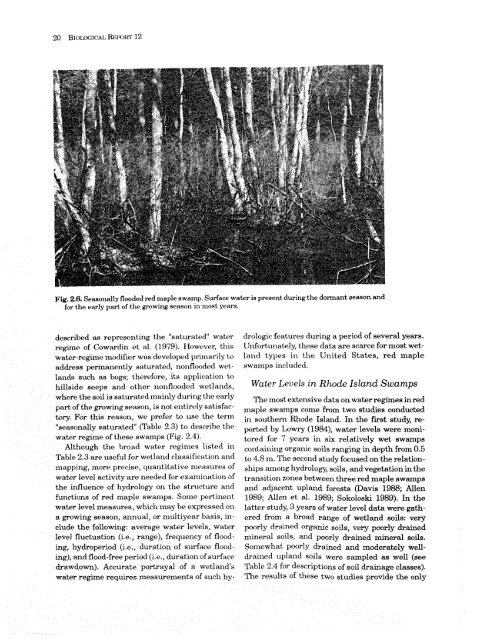
in the 1-m-thick organic soils was rapidly depleted by evapotranspiration. During the study period (April to November), total evapotranspiration from the wetland was roughly equal to rainfall, and streamflow out of the swamp was maintained by streamflow in. Water storage in the peat was insufficient to sustain flows in tributary channels throughout the year, but the swamp soils absorbed much of the rainfall from summer storms, thereby temporarily maintaining flow in some of the wetland streams. In light of the great variety of hydrogeologic settings in which red maple swamps occur, the results reported by O wen (1977) and Woo and Vdverde (1981) probably represent only a fraction of the hydrologic variability to be encountered in this wetland type. The magnitude of the various components in the water budget of individual wetlands can be expected to vary with topographic and hydrogeologic setting, watershed size, soil composition, relative development of surface-water drainage systems, and other site factors. Until detailed water-balance studies are conducted in red maple swamps in a wide variety of settings, relationships between these wetlands and associated groundwater and surface-water systems can be described only in general terms. Water Regimes Definitions and Key Churacterist ics The net result of all inflow and outflow of water to and from a wetland at any point in time is indicated by the position of the water level in the wetland. The elevation and degree of fluctuation of the water table with respect to the land surface over time is referred to as the wetland's water regime (Golet and Lowry 1987). Because of the wide variation in water levels among years in many wetlands, water-regime descriptions are most meaningful, particularly from an ecological standpoint, when expressed as the condition to be expected in most years. Cowardin et d. (1979) recognized eight nontidal water regimes, two of which accurately depict the hydrologic conditions found in northeastern red maple swamps Cfable 2.3). Most red maple forested wetlands located in basins and fed by groundwater as well as overland flow (i.e., groundwater depression wetlands) are seasonally flooded (see Fig. 2.6). The temporarily flooded regime occurs primarily in surface-water depression wet- Table 2.3. Water regimes of northeusten red maple swamps. Water regime Definition Seasonally floodeda Surface water is present for extended periods, especially early in the growing season, but is absent by the end of the season in most years; when surface water is absent. the water table is often near the land surface Temporarily floodeda Surface water is present for brief periods during the growing season, but the water table usually lies well below the soil surface for most of the season Seasonally saturatedb The soil is saturated to the surface, especially early in the growing season, but unsaturated conditions prevail by the end of the season in most years; surface water is absent except for groundwater seepage and overland flow - alldinition according to Cowardin et al. (1979). b~efinition by the authors of this community profile. lands and surface-water slope wetlands, where groundwater inflow is minimal and overland flow or overbank flooding by streams and lakes provides the principal source of water for the wetland. Red maple is found in temporarily flooded situations, but frequently the duration of flooding and soil saturation at such sites during the growing season is so brief that species better adapted to those conditions predominate. In southern Rhode Island, for example, pin oak and swamp white oak commonly dominate the temporarily flooded zone of surface-water depression wetlands located in till. On northeastern stream floodplains, a variety of tree species, including silver maple, ashes, cottonwood, black willow, boxelder (Acer negundo), American elm, and sycamore, usually dominates the temporarily flooded zone, while red maple is found mainly in seasonally flooded depressions, where soils are saturated for longer periods. In rare instances, red maple swamps located along tidal fresh rivers may be tidally influenced (e.g., McVaugh 1958). Red maple swamps on hillsides fed by groundwater discharge (i.e., groundwater slope wetlands) are not flooded, in the strict sense, but are best
Fig, 23.6,Soasonally flmded red maple tlwamp. SurfRce w ~tr is present during the dormant season and for the exrrly part af thc growing Reasoil in most years. dowrikad as rpre13~xxting the "saturated" water mgirrre of (lowardirx et ;ti. (1979), fiowcver, wabar-~>girnc> x~nr~tlifirr ww cievc'ioyx?cj primarily tx, ktddrerss ~pc;'rnxar~r?ntty sakurabd, r~o~iflcmded wet - lax~ds such RN bogs; fl~c:r~for~, it8 applicaLioll Lo hilleide suul>a sirid other ~xoxtflooclc-d w~tlntlds, wkprt3 tho mil is sattlrakd rnaillfy durixlg the emiy part of the vowing Reason, is rxot t.rh,irc>ly satisfacbrye For this reaeon, WC? prefer to UT)C~ the kml "scasondly saturat~~c1" (Trltrlc 2.3) to dcscriba tho wnkr regime of tll~t*t.st* swamps (Fig. 2.4). Rltilough Ule t)rc)nd wnler regi1nc.s listed in 'rt~blo 2.3 are UBG~LI~ for wetland c1ar;sific;ttioa and mappimrg, nlorr* precise, t ~~~~ltitativ~ 1~1e;tstlres of water level activity arc xlt*~ded for cxnzllir~at~iorl of the influences of hydroloo on the structure axrd funcliox~ri of red maple swm~ps. Some pertinent. watxr level nleasures, whidl may be expressed on a growing sectson, sirumua1, or nlultiyear basis, include the following: average wakr levels, water level fluctuation (i.e., range), frequency of flooding, hydroperiod (Lo., duration of surfnee floocting), and flood-free period (i.e., duration of surface &awdomf. hecarate portrayal of a w~etlctnd"~ wahr reghe requires measuremen& of such by- clrologic feat,ures during a period of several years. Illnfortur~ntely, these data are scarce for most wetland types in the United States, red maple swamps irrrluded. Water Levels ir-t Rho& Island Swamps 'I%e nrost extensive data on water regimes in red rnaple swamps come from two studies conducted in south en^ Rhode Island. In the first study, reported by Lowry (1984), water levels were monitux-od for 7 years in six relatively wet swamps
- Page 2 and 3: Technical IIbpg~rt Series U.S. Fish
- Page 5 and 6: Preface In many areas of the glacia
- Page 7 and 8: Acer rubrum (red maple) diagnostic
- Page 9 and 10: Zone 111 . St . Lawrence Valley and
- Page 11 and 12: Fig . 3.7. Red maple swap with unde
- Page 13 and 14: Table 4.5. Flood tolerance of trees
- Page 15 and 16: Chapter I. Introduction Wetland kbr
- Page 17 and 18: Regional Setting throughout the gla
- Page 19 and 20: C-J Spruce-Fa Beech-Birch-Maple Mit
- Page 21 and 22: Fig. 1.4. The range of red maple (a
- Page 23 and 24: ~ b 1.5, h fircort~ of Wet landc Ir
- Page 25 and 26: Fig. 22. &~lrit~ve Irtndtici~pe yos
- Page 27 and 28: egional groundwakr table by the roc
- Page 29 and 30: y e~rr~mtrtm~~,irzst ion. Cat~t,inu
- Page 31: inflow^ Outflows OF SWQ SWI Fig. 25
- Page 35 and 36: Fig. 27. Water levels in six mode I
- Page 37 and 38: The duration of soil saturation has
- Page 39 and 40: Organic soils are always very poorl
- Page 41 and 42: Chapter 3. The Plant Community The
- Page 43 and 44: .dar02f 'B Xi? s%u?mma -?sway+xqq p
- Page 47 and 48: Community S tructare Red maple swam
- Page 49 and 50: suggesta a strong correlation betwe
- Page 51 and 52: Table 3.2. Stmtuml chumcteristics o
- Page 53 and 54: Table 3.3. Continued. "- -- - Speci
- Page 55 and 56: Table __ 3.3. _ Continued ._.lll.__
- Page 57 and 58: Table 3.3. Continued. . * - __.. ^.
- Page 59 and 60: Zone I II III TV C" Drppnmriad* sp.
- Page 61 and 62: on Long Island, pin oak, swamp whit
- Page 63 and 64: fern moea (?ki.c&inz &limfulum), an
- Page 65 and 66: countered (Table 3.3). The herb lay
- Page 67 and 68: ~akareous Seepage Swamps England si
- Page 69 and 70: and globeflower are. listed in four
- Page 71 and 72: was the most likely reason for diff
- Page 73 and 74: kvei fluctuation during the gmwing
- Page 75 and 76: Table 4.2. .Rektit.e ~bmchnce w Q)
- Page 77 and 78: difficuit to delineate in many inst
- Page 79 and 80: in the librature btlx>~ithe moi~ttl
- Page 81 and 82: Origin. an$ Relationship to Water R
Fig, 23.6,Soasonally flmded red maple tlwamp. SurfRce w ~tr is present dur<strong>in</strong>g <strong>the</strong> dormant season and<br />
for <strong>the</strong> exrrly part af thc grow<strong>in</strong>g Reasoil <strong>in</strong> most years.<br />
dowrikad as rpre13~xxt<strong>in</strong>g <strong>the</strong> "saturated" water<br />
mgirrre <strong>of</strong> (lowardirx et ;ti. (1979), fiowcver,<br />
wabar-~>girnc> x~nr~tlifirr ww cievc'ioyx?cj primarily tx,<br />
ktddrerss ~pc;'rnxar~r?ntty sakurabd, r~o~iflcmded wet -<br />
lax~ds such RN bogs; fl~c:r~for~, it8 applicaLioll Lo<br />
hilleide suul>a sirid o<strong>the</strong>r ~xoxtflooclc-d w~tlntlds,<br />
wkprt3 tho mil is sattlrakd rnaillfy durixlg <strong>the</strong> emiy<br />
part <strong>of</strong> <strong>the</strong> vow<strong>in</strong>g Reason, is rxot t.rh,irc>ly satisfacbrye<br />
For this reaeon, WC? prefer to UT)C~ <strong>the</strong> kml<br />
"scasondly saturat~~c1" (Trltrlc 2.3) to dcscriba tho<br />
wnkr regime <strong>of</strong> tll~t*t.st* swamps (Fig. 2.4).<br />
Rltilough Ule t)rc)nd wnler regi1nc.s listed <strong>in</strong><br />
'rt~blo 2.3 are UBG~LI~<br />
for wetland c1ar;sific;ttioa and<br />
mappimrg, nlorr* precise, t ~~~~ltitativ~ 1~1e;tstlres <strong>of</strong><br />
water level activity arc xlt*~ded for cxnzllir~at~iorl <strong>of</strong><br />
<strong>the</strong> <strong>in</strong>fluences <strong>of</strong> hydroloo on <strong>the</strong> structure axrd<br />
funcliox~ri <strong>of</strong> red maple swm~ps. Some pert<strong>in</strong>ent.<br />
watxr level nleasures, whidl may be expressed on<br />
a grow<strong>in</strong>g sectson, sirumua1, or nlultiyear basis, <strong>in</strong>clude<br />
<strong>the</strong> follow<strong>in</strong>g: average wakr levels, water<br />
level fluctuation (i.e., range), frequency <strong>of</strong> flood<strong>in</strong>g,<br />
hydroperiod (Lo., duration <strong>of</strong> surfnee flooct<strong>in</strong>g),<br />
and flood-free period (i.e., duration <strong>of</strong> surface<br />
&awdomf. hecarate portrayal <strong>of</strong> a w~etlctnd"~<br />
wahr reghe requires measuremen& <strong>of</strong> such by-<br />
clrologic feat,ures dur<strong>in</strong>g a period <strong>of</strong> several years.<br />
Illnfortur~ntely, <strong>the</strong>se data are scarce for most wetland<br />
types <strong>in</strong> <strong>the</strong> United States, red maple<br />
swamps irrrluded.<br />
Water Levels ir-t Rho& Island <strong>Swamps</strong><br />
'I%e nrost extensive data on water regimes <strong>in</strong> red<br />
rnaple swamps come from two studies conducted<br />
<strong>in</strong> south en^ Rhode Island. In <strong>the</strong> first study, reported<br />
by Lowry (1984), water levels were monitux-od<br />
for 7 years <strong>in</strong> six relatively wet swamps<br />


