

Ecology of Red Maple Swamps in the Glaciated Northeast: A ...
Ecology of Red Maple Swamps in the Glaciated Northeast: A ...
Ecology of Red Maple Swamps in the Glaciated Northeast: A ...

Create successful ePaper yourself
Turn your PDF publications into a flip-book with our unique Google optimized e-Paper software.
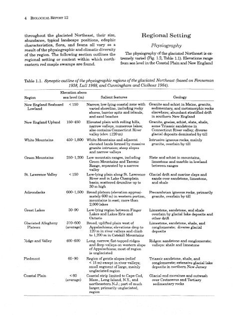
Regional Sett<strong>in</strong>g<br />
throughout <strong>the</strong> glaciated Nor<strong>the</strong>ast, <strong>the</strong>ir size,<br />
-<br />
abundance, typicd landscape positions, edaphic<br />
characteristics, flora, and fauna all vary as a<br />
Pk~ysiography<br />
result <strong>of</strong> <strong>the</strong> physiographic and climatic diversity<br />
<strong>of</strong> <strong>the</strong> region. The follow<strong>in</strong>g section outl<strong>in</strong>es <strong>the</strong> The physiogrcbphy <strong>of</strong> <strong>the</strong> glaciated Nor<strong>the</strong>ast is exregional<br />
sett<strong>in</strong>g or context with<strong>in</strong> which north- tremely varied (Fig. 1.2, Table 1.1). Elevations<br />
eastern red maple swamps are found.<br />
from sea level <strong>in</strong> <strong>the</strong> Goastal Ra<strong>in</strong> arid New England<br />
Table 1 .I, Synoptic outl<strong>in</strong>e <strong>of</strong> <strong>the</strong> physiographic regions <strong>of</strong> <strong>the</strong> glaciated Nortkmt (based on Fenneman<br />
1938, Lull 1968, and Cunn<strong>in</strong>ghum and Ciolkosz 1984).<br />
Elevation above<br />
Region sea level (m) Salient features Geology<br />
New England Seaboard<br />
Lowland<br />
New England Upland<br />
White Mounta<strong>in</strong>s<br />
Green Mounta<strong>in</strong>s<br />
St. Lawrence Valley<br />
Great Lakes<br />
<strong>Glaciated</strong> ,4llegheny<br />
Plateau<br />
Xidge and Valley<br />
Piedmont<br />
Coastal Pla<strong>in</strong><br />
370-600<br />
(average)<br />
< 60<br />
(average)<br />
Narrow, low-ly<strong>in</strong>g coastal zone with<br />
varied shorel<strong>in</strong>e, <strong>in</strong>clud<strong>in</strong>g rocky<br />
shores, barrier spits and islands,<br />
and sand beaches<br />
Elevated pla<strong>in</strong> with roll<strong>in</strong>g hills,<br />
narrow valleys, numerous lakes;<br />
also conta<strong>in</strong>s Connecticut River<br />
valley (elev. 5120 m)<br />
White Mounta<strong>in</strong>s and adjacent<br />
elevated lands formed by massive<br />
granite <strong>in</strong>trusion; steep slopes<br />
and narrow valleys<br />
Low mounta<strong>in</strong> ranges, <strong>in</strong>clud<strong>in</strong>g<br />
Green Mounta<strong>in</strong>s and Taconic<br />
Range, separated by a narrow<br />
valley<br />
Low-ly<strong>in</strong>g pla<strong>in</strong> along St. Lawrence<br />
Ever and <strong>in</strong> Lake Champla<strong>in</strong><br />
bas<strong>in</strong>; scattered druml<strong>in</strong>s up to<br />
30 m high<br />
Broad plateau (elevation approximately<br />
600 m) <strong>in</strong> western portion,<br />
mounta<strong>in</strong>s <strong>in</strong> east; more than<br />
2,000 lakes<br />
Low-ly<strong>in</strong>g region between F<strong>in</strong>ger<br />
Lakes and skes Erie and<br />
Ontario<br />
Broad, uplifted pla<strong>in</strong> west <strong>of</strong><br />
Appalachians; elevations drop to<br />
120 m <strong>in</strong> river valleys and climb<br />
to 1,200 m <strong>in</strong> Catskill Mounta<strong>in</strong>s<br />
Long, narrow, flat-topped ridges<br />
and deep valleys on western slope<br />
<strong>of</strong> Appalachians; most <strong>of</strong> region<br />
is unglaciakd<br />
Region <strong>of</strong> gentle slopes (relief<br />
< 15 m) except <strong>in</strong> river valleys;<br />
sndl segment <strong>of</strong> large, mairJy<br />
unglaciated region<br />
Coastal strip limited to Cape Cod,<br />
Mass., hng Island, N.Y., and<br />
nor<strong>the</strong>astern N.J.; part <strong>of</strong> much<br />
larger, primarily unglaciated,<br />
region<br />
Granite and schist <strong>in</strong> Ma<strong>in</strong>e, granite,<br />
sedimentary, and metamorphic rocks<br />
elsewhere; abundant stratified drift<br />
<strong>in</strong> sou<strong>the</strong>rn New England<br />
Granite, gneiss, schist, slate, shale,<br />
some Thassic sandstone <strong>in</strong><br />
Connecticut River valley; diverse<br />
glacial deposits dom<strong>in</strong>ated by till<br />
Intrusive igneous rocks, ma<strong>in</strong>ly<br />
granite, overla<strong>in</strong> by till<br />
Slate and schist <strong>in</strong> mounta<strong>in</strong>s,<br />
limestone and marble <strong>in</strong> lowland<br />
between ranges<br />
Glacial drift and mar<strong>in</strong>e clays and<br />
sands over sandstone, limestone,<br />
and shale<br />
Precambrian igneous rocks, primarily<br />
granite, overla<strong>in</strong> by till<br />
Limestone, sandstone, and shale<br />
overla<strong>in</strong> by glacial Iake deposib and<br />
o<strong>the</strong>r drift<br />
Limestone, sandstone, shale, and<br />
conglomerate; diverse glacial<br />
deposits<br />
Ridges: sandstone and conglomerate;<br />
valleys: shale and limestone<br />
Triassic sandstone, shale, and<br />
conglomerate; extensive glacial lake<br />
deposits -h nor<strong>the</strong>rn New Jersey<br />
Glacial end mora<strong>in</strong>es and outwash<br />
over Cretaceous and Tertiary<br />
sedimentary rocks


