corrosive species and scaling in wells at olkaria ... - Orkustofnun
corrosive species and scaling in wells at olkaria ... - Orkustofnun
corrosive species and scaling in wells at olkaria ... - Orkustofnun

You also want an ePaper? Increase the reach of your titles
YUMPU automatically turns print PDFs into web optimized ePapers that Google loves.
the Western Sectors. The<br />
Olkaria III plant, oper<strong>at</strong>ed by<br />
Orpower 4 Inc., a subsidiary<br />
of Orm<strong>at</strong> Intern<strong>at</strong>ional<br />
gener<strong>at</strong>es 12 MWe <strong>and</strong> ~ 2<br />
MWe are gener<strong>at</strong>ed by a<br />
flower farm, Oserian<br />
Development Company from<br />
<strong>wells</strong> leased from KenGen.<br />
These two plants are organic<br />
Rank<strong>in</strong>e Orm<strong>at</strong> cycle plants.<br />
Plans are underway to exp<strong>and</strong><br />
the capacity of Olkaria II<br />
plant <strong>in</strong> the Olkaria North<br />
East Field from 70 MWe to<br />
105 MWe by the year 2007<br />
(Mwangi, 2005) <strong>and</strong> the<br />
Orpower 4 Inc. plant from 12<br />
Mwe to 48 Mwe by 2006<br />
(Reshef <strong>and</strong> Citr<strong>in</strong>, 2003).<br />
The geology around Olkaria<br />
has been studied by<br />
North<strong>in</strong>gs (m)<br />
9906000<br />
9905000<br />
9904000<br />
9903000<br />
9902000<br />
9901000<br />
9900000<br />
9899000<br />
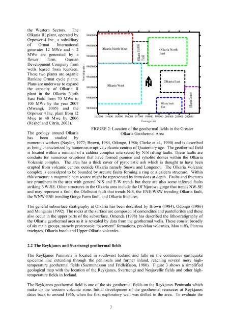
Olkaria North West<br />
Olkaria West<br />
193000 194000 195000 196000 197000 198000 199000 200000 201000 202000<br />
East<strong>in</strong>gs (m)<br />
FIGURE 2: Loc<strong>at</strong>ion of the geothermal fields <strong>in</strong> the Gre<strong>at</strong>er<br />
Olkaria Geothermal Area<br />
numerous workers (Naylor, 1972; Brown, 1984, Odongo, 1986; Clarke et al., 1990) <strong>and</strong> is described<br />
as be<strong>in</strong>g characterized by numerous eruptive volcanic centres of Qu<strong>at</strong>ernary age. The geothermal field<br />
is loc<strong>at</strong>ed with<strong>in</strong> a remnant of a caldera complex <strong>in</strong>tersected by N-S rift<strong>in</strong>g faults. These faults are<br />
conduits for numerous eruptions th<strong>at</strong> have formed pumice <strong>and</strong> ryholite domes with<strong>in</strong> the Olkaria<br />
Volcanic complex. The area has a thick cover of pyroclastic ash which is thought to have been<br />
erupted from volcanic centres outside Olkaria namely Suswa <strong>and</strong> Longonot. The Olkaria Volcanic<br />
complex is considered to be bounded by arcu<strong>at</strong>e faults form<strong>in</strong>g a r<strong>in</strong>g or a caldera structure. With<strong>in</strong><br />
this structure a magm<strong>at</strong>ic he<strong>at</strong> source might be represented by <strong>in</strong>trusions <strong>at</strong> depth. Faults <strong>and</strong> fractures<br />
are prom<strong>in</strong>ent <strong>in</strong> the area with general N-S <strong>and</strong> E-W trends but there are also some <strong>in</strong>ferred faults<br />
strik<strong>in</strong>g NW-SE. Other structures <strong>in</strong> the Olkaria area <strong>in</strong>clude the Ol’Njorowa gorge th<strong>at</strong> trends NW-SE<br />
<strong>and</strong> may represent a fault, the Ololbutot fault th<strong>at</strong> trends N-S, the ENE-WSW trend<strong>in</strong>g Olkaria fault,<br />
the WNW-ESE trend<strong>in</strong>g Gorge Farm fault, <strong>and</strong> Olkaria fractures.<br />
The general subsurface str<strong>at</strong>igraphy <strong>at</strong> Olkaria has been described by Brown (1984), Odongo (1986)<br />
<strong>and</strong> Mungania (1992). The rocks <strong>at</strong> the surface are composed of comendites <strong>and</strong> pantellerites <strong>and</strong> these<br />
also occur <strong>in</strong> the upper parts of the subsurface. Omenda (1998) has described the lithostr<strong>at</strong>igraphy of<br />
the Olkaria geothermal area as it is revealed by d<strong>at</strong>a from the geothermal <strong>wells</strong>. These consist broadly<br />
of six ma<strong>in</strong> groups, namely proterozoic “basement” form<strong>at</strong>ions, pre-Mau volcanics, Mau tuffs, Pl<strong>at</strong>eau<br />
trachytes, Olkaria basalt <strong>and</strong> Upper Olkaria volcanics.<br />
Olkaria Central<br />
Field<br />
Olkaria North<br />
East<br />
Olkaria East<br />
Olkaria South<br />
East<br />
Olkaria Domes<br />
2.2 The Reykjanes <strong>and</strong> Svartsengi geothermal fields<br />
The Reykjanes Pen<strong>in</strong>sula is loc<strong>at</strong>ed <strong>in</strong> southwest Icel<strong>and</strong> <strong>and</strong> falls on the cont<strong>in</strong>uous earthquake<br />
epicentre l<strong>in</strong>e extend<strong>in</strong>g through the pen<strong>in</strong>sula <strong>and</strong> further <strong>in</strong>l<strong>and</strong>, reach<strong>in</strong>g several more hightemper<strong>at</strong>ure<br />
geothermal fields (Saemundsson <strong>and</strong> Fridleifsson, 1980). Figure 3 shows a simplified<br />
geological map with the loc<strong>at</strong>ion of the Reykjanes, Svartsengi <strong>and</strong> Nesjavellir fields <strong>and</strong> other hightemper<strong>at</strong>ure<br />
fields <strong>in</strong> Icel<strong>and</strong>.<br />
The Reykjanes geothermal field is one of the six geothermal fields on the Reykjanes Pen<strong>in</strong>sula which<br />
make up the western volcanic zone. Initial development of the geothermal resources <strong>at</strong> Reykjanes<br />
d<strong>at</strong>es back to around 1956, when the first explor<strong>at</strong>ory well was drilled <strong>in</strong> the area. To evalu<strong>at</strong>e the<br />
7