Appendix C - Cultural Heritage Impact Assessment - Peabody Energy
Appendix C - Cultural Heritage Impact Assessment - Peabody Energy Appendix C - Cultural Heritage Impact Assessment - Peabody Energy
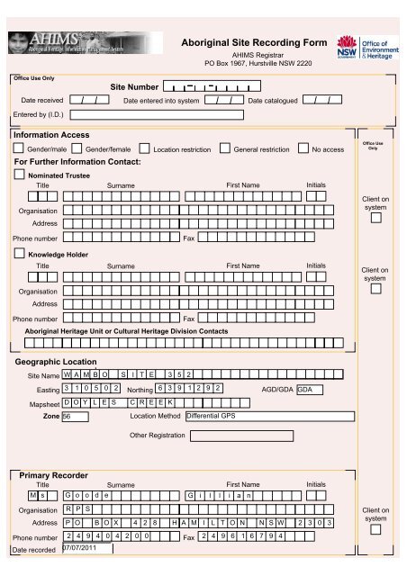
Office Use Only Entered by (I.D.) Site Number Aboriginal Site Recording Form AHIMS Registrar PO Box 1967, Hurstville NSW 2220 Date received Date entered into system Date catalogued Information Access Gender/male For Further Information Contact: Gender/female Location restriction General restriction No access Nominated Trustee Title Surname First Name Organisation Address Initials Office Use Only Client on system Phone number Fax Knowledge Holder Title Surname First Name Organisation Address Phone number Fax Aboriginal Heritage Unit or Cultural Heritage Division Contacts Initials Client on system Geographic Location Site Name W A M B O S I T E 3 5 2 Easting 3 1 0 5 0 2 Northing 6 3 9 1 2 9 2 Mapsheet D O Y L E S C R E E K Zone 56 Location Method Differential GPS AGD/GDA GDA Other Registration Primary Recorder Title Surname First Name M s G o o d e G i l l i a n Initials Organisation Address Phone number Date recorded R P S P O B O X 4 2 8 H A M I L T O N N S W 2 3 0 3 2 4 9 4 0 4 2 0 0 Fax 2 4 9 6 1 6 7 9 4 07/07/2011 Client on system
NPWS Aboriginal Site Recording Form - Site Information OPEN/CLOSE SITE Site Context Landform Landform Unit Open Site page 2 Mountainous Beach Tidal Flat Upper slope Stream bank ✔ Plain Rolling hills Coastal rock platform Dune Cliff Crest Plain Ridge Stream channel Swamp Steep hills Undulating plain Intertidal flat Lagoon ✔ Flat Lower slope Tor Valley flat Terrace Terrace flat Slope Tidal Creek Mid slope Levy degrees Vegetation Closed forest Grasslands Isolated clumps of trees Open forest ✔ Open woodland Scrub Woodland ✔ Cleared Revegetated N/A Land use Conservation Established urban Farming-intensive Farming-low intensity Forestry Industrial Mining ✔ Pastoral/grazing Recreation Semi-rural Service corridor Transport corridor Urban expansion Residential Water Distance to permanent water source Distance to temporary water source 700 300 metres metres Name of nearest permanent water source Stony Creek Name of nearest temporary water 1st order tributary Directions for Relocation See attached map and GPS coordinates. Site Location Map NW N NE Current Land Tenure National Park / other Government Public Dept. ✔ Private Primary report I.D. (I.D. Office Use only) W N E SW S SE
- Page 156 and 157: Office Use Only Entered by (I.D.) S
- Page 158 and 159: NPWS Aboriginal Site Recording Form
- Page 160 and 161: NPWS FEATURE RECORDING FORM - ARTEF
- Page 162 and 163: Table: Artefact Attributes ID Artef
- Page 173 and 174: Office Use Only Entered by (I.D.) S
- Page 175 and 176: NPWS Aboriginal Site Recording Form
- Page 177 and 178: NPWS FEATURE RECORDING FORM - ARTEF
- Page 179 and 180: Site Description Wambo Site 348 (AS
- Page 188 and 189: Office Use Only Entered by (I.D.) S
- Page 190 and 191: NPWS Aboriginal Site Recording Form
- Page 192 and 193: NPWS FEATURE RECORDING FORM - ARTEF
- Page 194 and 195: Site Description This artefact scat
- Page 198 and 199: NPWS Aboriginal Site Recording Form
- Page 200 and 201: NPWS FEATURE RECORDING FORM - ARTEF
- Page 202 and 203: Site Description Wambo Site 352 (Ar
- Page 204 and 205: Office Use Only Entered by (I.D.) S
- Page 206 and 207: NPWS Aboriginal Site Recording Form
- Page 208 and 209: NPWS FEATURE RECORDING FORM - ARTEF
- Page 210 and 211: Site Description Wambo Site 353 (Ar
- Page 212 and 213: Office Use Only Entered by (I.D.) S
- Page 214 and 215: NPWS Aboriginal Site Recording Form
- Page 216 and 217: NPWS FEATURE RECORDING FORM - ARTEF
- Page 218 and 219: Site Description This artefact scat
- Page 220 and 221: Office Use Only Entered by (I.D.) S
- Page 222 and 223: NPWS Aboriginal Site Recording Form
- Page 224 and 225: NPWS FEATURE RECORDING FORM - ARTEF
- Page 226 and 227: Site Description This artefact scat
- Page 228 and 229: Office Use Only Entered by (I.D.) S
- Page 230 and 231: NPWS Aboriginal Site Recording Form
- Page 232 and 233: NPWS FEATURE RECORDING FORM - ARTEF
- Page 234 and 235: Site Description This artefact scat
- Page 236 and 237: NPWS Aboriginal Site Recording Form
- Page 238 and 239: NPWS Aboriginal Site Recording Form
- Page 240 and 241: NPWS FEATURE RECORDING TABLE - ARTE
- Page 242: Wambo Site 358 isolated find pink m
Office Use Only<br />
Entered by (I.D.)<br />
Site Number<br />
Aboriginal Site Recording Form<br />
AHIMS Registrar<br />
PO Box 1967, Hurstville NSW 2220<br />
Date received Date entered into system Date catalogued<br />
Information Access<br />
Gender/male<br />
For Further Information Contact:<br />
Gender/female Location restriction General restriction No access<br />
Nominated Trustee<br />
Title Surname First Name<br />
Organisation<br />
Address<br />
Initials<br />
Office Use<br />
Only<br />
Client on<br />
system<br />
Phone number<br />
Fax<br />
Knowledge Holder<br />
Title Surname First Name<br />
Organisation<br />
Address<br />
Phone number<br />
Fax<br />
Aboriginal <strong>Heritage</strong> Unit or <strong>Cultural</strong> <strong>Heritage</strong> Division Contacts<br />
Initials<br />
Client on<br />
system<br />
Geographic Location<br />
Site Name W A M B O S I T E 3 5 2<br />
Easting 3 1 0 5 0 2 Northing 6 3 9 1 2 9 2<br />
Mapsheet D O Y L E S C R E E K<br />
Zone 56<br />
Location Method Differential GPS<br />
AGD/GDA<br />
GDA<br />
Other Registration<br />
Primary Recorder<br />
Title Surname First Name<br />
M s G o o d e G i l l i a n<br />
Initials<br />
Organisation<br />
Address<br />
Phone number<br />
Date recorded<br />
R P S<br />
P O B O X 4 2 8 H A M I L T O N N S W 2 3 0 3<br />
2 4 9 4 0 4 2 0 0 Fax 2 4 9 6 1 6 7 9 4<br />
07/07/2011<br />
Client on<br />
system


