

Soils of the - Agriculture and Agri-Food Canada
Soils of the - Agriculture and Agri-Food Canada
Soils of the - Agriculture and Agri-Food Canada

You also want an ePaper? Increase the reach of your titles
YUMPU automatically turns print PDFs into web optimized ePapers that Google loves.
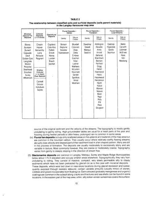
TABLE 2<br />
The relationship between classified soils <strong>and</strong> surf icial deposits (soils parent materials )<br />
in <strong>the</strong> Langley-Vancouver map area<br />
Morainal<br />
(Glacial Till )<br />
Deposits<br />
Colluvial<br />
Deposits<br />
(>1 m thick)<br />
Glaci<strong>of</strong>luvial<br />
Deposits<br />
Fluvial Deposits-<br />
Deltaic<br />
S<strong>and</strong>y<br />
Fluvial Deposits-<br />
Floodplain<br />
Fluvial Deposits-<br />
Local Stream s<br />
Silty or silty or silty or<br />
Clayey<br />
S<strong>and</strong>y Clayey S<strong>and</strong>y Clayey<br />
Blaney Cheam Capilano Benson Blundell Dewdney Addington Eastcap Bates<br />
Buntzen Hoover Columbia Neptune Crescent Grevell Alouette Hopedale Carvolt h<br />
Burwell Kenworthy Defehr Seaview Deas Matsqui Annis Sardis Lickma n<br />
Cascade Lions Errock Tsawwassen Delta Seabird Arnold Seymour McElvee<br />
Devil Palisade Haney Embree Beharrel Ros s<br />
Golden Ears Poignant Lynden Guichon Blackburn Si m<br />
Langdale Roach Kilter Bonson Westlan g<br />
Marion Sechelt Ladner Fairfiel d<br />
Porpoise Ma<strong>the</strong>ws Grig g<br />
Steelhead shallow McLellan Hallert<br />
Strachan Colluvial Nicomekl Hammon d<br />
Surrey<br />
S<strong>and</strong>el<br />
Hatzi c<br />
ôve Bedrock<br />
Whonnock<br />
Spetifore<br />
Hazelwood<br />
Vinod<br />
Henderso n<br />
Cannell<br />
Westham<br />
Hjort h<br />
Grouse<br />
Hollyburn<br />
Sayres<br />
Katzi e<br />
Monro e<br />
Neaves<br />
Nive n<br />
Pag e<br />
Pell y<br />
Pitt<br />
Prest<br />
Sturgeon<br />
(iv)<br />
source <strong>of</strong> <strong>the</strong> original sediment <strong>and</strong> <strong>the</strong> velocity <strong>of</strong> <strong>the</strong> streams . The topography is mostly gentl y<br />
undulating to gently rolling . High groundwater tables are usual for at least parts <strong>of</strong> <strong>the</strong> year an d<br />
flooding during freshet periods or after heavy, prolonged rain is common in some areas .<br />
Fluvial fan deposits occupy only scattered areas on <strong>the</strong> upl<strong>and</strong>s <strong>and</strong> lowl<strong>and</strong>s <strong>of</strong> <strong>the</strong> map area bu t<br />
are common in <strong>the</strong> mountain valleys . They usually occur where relatively swiftly flowing stream s<br />
abruptly lose velocity <strong>and</strong> deposit part <strong>of</strong> <strong>the</strong>ir sediment load in a fan shaped pattern . Many are stil l<br />
in <strong>the</strong> process <strong>of</strong> formation . The deposits are usually moderately to excessively stony <strong>and</strong> ar e<br />
variable in texture . Most commonly however, <strong>the</strong>y are coarse or moderately coarse . Topograph y<br />
varies from gently to steeply sloping in <strong>the</strong> direction <strong>of</strong> stream flow .<br />
(5) Glaciomarine deposits are common in Langley, Matsqui, Surrey <strong>and</strong> Maple Ridge Municipalitie s<br />
below about 175 m elevation <strong>and</strong> occupy smaller areas elsewhere . Topographically, <strong>the</strong>y vary fro m<br />
undulating to rolling . They consist <strong>of</strong> massive, compact, very slowly permeable silty to claye y<br />
sediments which have not been preloaded by glacial ice as is <strong>the</strong> case with morainal deposits .<br />
These deposits, which were laid down in near-shore locations during glacial recession <strong>and</strong> subsequently<br />
exposed through isostatic rebound, contain variable amounts (usually minor) <strong>of</strong> stones ,<br />
cobbles <strong>and</strong> gravel incorporated from floating ice . Dark coloured (probably manganese <strong>and</strong> organic )<br />
coatings are common in <strong>the</strong> subsoil along cracks <strong>and</strong> fractures <strong>and</strong> sea shells can be found in som e<br />
locations . In <strong>the</strong> eastern part <strong>of</strong> <strong>the</strong> map area, a thin, silty eolian veneer sometimes covers <strong>the</strong> surface .<br />
1 0


