

Soils of the - Agriculture and Agri-Food Canada
Soils of the - Agriculture and Agri-Food Canada
Soils of the - Agriculture and Agri-Food Canada

Create successful ePaper yourself
Turn your PDF publications into a flip-book with our unique Google optimized e-Paper software.
R<strong>and</strong> designated as agriculture l<strong>and</strong> reserves by <strong>the</strong> British Columbia <strong>Agri</strong>cultural L<strong>and</strong> Commission . Many lar<br />
parcels . particularly in <strong>the</strong> 'upl<strong>and</strong>' areas . are small in size <strong>and</strong> are used basically as urban sites in a ru r :<br />
setting. Adjacent to <strong>the</strong> existing metropolitan area <strong>and</strong> around most <strong>of</strong> <strong>the</strong> larger towns much good agricultura l<br />
l<strong>and</strong> has in <strong>the</strong> past been converted to urban . commercial or industrial uses .<br />
Forestry is a major [<strong>and</strong> use in <strong>the</strong> mountainous nor<strong>the</strong>rn part <strong>of</strong> <strong>the</strong> report area. Several managed ar<br />
protected watersheds north <strong>of</strong> Vancouver provide <strong>the</strong> metropolitan area with abundant, excellent qualit y<br />
domestic water Several provincial <strong>and</strong> regional parks . providing a wide variety <strong>of</strong> year-around . recreationa l<br />
facilities are also present Cottaging <strong>and</strong> water oriented recreation uses are important on <strong>the</strong> Sunshine Coas t<br />
<strong>and</strong> on Bowen <strong>and</strong> Gambier Isl<strong>and</strong>s .<br />
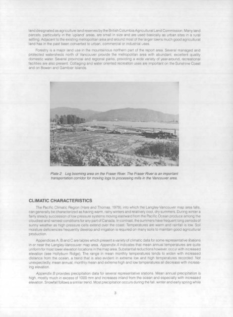
Plate 2 Log booming area on <strong>the</strong> Fraser River. The Fraser River is an importan t<br />
transportation corridor for moving logs to processing mills in <strong>the</strong> Vancouver area .<br />
CLIMATIC CHARACTERISTIC S<br />
The Pacific Climatic Region (Hare <strong>and</strong> Thomas . 1979), into which <strong>the</strong> Langley-Vancouver map area falls ,<br />
-, can generally be characterized as having warm, rainy winters <strong>and</strong> relatively cool, dry summers . During winter a<br />
~-- fairly steady succession <strong>of</strong> low pressure systems moving eastward from <strong>the</strong> Pacific Ocean produce among t h<br />
cloudiest <strong>and</strong> rainiest conditions for any part <strong>of</strong> <strong>Canada</strong> . In contrast. <strong>the</strong> summers have frequent long period s<br />
lit-- =s sunny wea<strong>the</strong>r as high pressure cells extend over <strong>the</strong> coast . Temperatures are warm <strong>and</strong> rainfall is low. Soi l<br />
r<br />
-aim moisture deficiencies frequently develop <strong>and</strong> irrigation is required on many soils to maintain good agricultura l<br />
production .<br />
Appendices A, B <strong>and</strong> C are tables which present a variety <strong>of</strong> climatic data for some representative stato r<br />
in or near <strong>the</strong> Langley-Vancouver map area . Appendix A indicates that mean annual temperatures are quit e<br />
uniform for most lower elevation locations in <strong>the</strong> map area . Substantial reductions however, occur with increase d<br />
elevation (see Hollyburn Ridge) . The range in mean monthly temperatures tends to widen with increase d<br />
distance from <strong>the</strong> ocean, a trend that is slso evident in extreme , iai <strong>and</strong> high temperatures recorded . No t<br />
unexpectedly. mean annual mortal t, xacme high r ineratures al l dec rease with increasing<br />
elevatio n<br />
Appendix B prov aes precipitation dn• . : ' representative statics ; Mean annual precipitation i s<br />
high, mostly much in excess <strong>of</strong> 1000 mm aria -creases inl<strong>and</strong> from <strong>the</strong> ocea' , 1 especial l y .v!Ih .ncrease d<br />
elevation . Snowfall follows a similar trend . Most precipitation occurs during 'h .-<br />
,


