Metro Vancouver's Watershed Management Plan
Metro Vancouver's Watershed Management Plan
Metro Vancouver's Watershed Management Plan

Create successful ePaper yourself
Turn your PDF publications into a flip-book with our unique Google optimized e-Paper software.
Greater<br />
Vancouver<br />
Regional<br />
District<br />
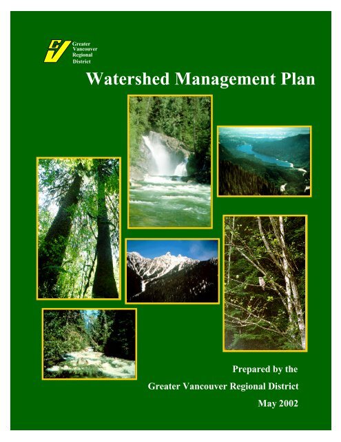
<strong>Watershed</strong> <strong>Management</strong> <strong>Plan</strong><br />
Prepared by the<br />
Greater Vancouver Regional District<br />
May 2002
<strong>Watershed</strong> <strong>Management</strong> <strong>Plan</strong><br />
For more information, contact:<br />
GVRD Policy and <strong>Plan</strong>ning Department<br />
4330 Kingsway<br />
Burnaby, B.C.<br />
V5H 4G8<br />
Tel: (604) 432-6375 Fax: (604) 436-6970<br />
Web site: www.gvrd.bc.ca<br />
Greater<br />
Vancouver<br />
Regional<br />
District
TABLE OF CONTENTS<br />
TABLE OF CONTENTS ..........................................................................................................................................................1<br />
PURPOSE AND SCOPE...........................................................................................................................................................2<br />
GOAL .........................................................................................................................................................................................2<br />
PRINCIPLES .............................................................................................................................................................................2<br />
MANAGEMENT STRATEGIES.............................................................................................................................................5<br />
IMPLEMENTATION PROGRAMS.......................................................................................................................................6<br />
1. Water Monitoring & Forecasting...............................................................................................................................6<br />
2. Forest Ecosystem <strong>Management</strong>..................................................................................................................................6<br />
3. Fire <strong>Management</strong> .......................................................................................................................................................7<br />
4. Erosion Control..........................................................................................................................................................8<br />
5. Road Network.............................................................................................................................................................9<br />
6. Water System Infrastructure.....................................................................................................................................12<br />
7. Communication and Education ................................................................................................................................12<br />
8. <strong>Watershed</strong> Security...................................................................................................................................................13<br />
9. Emergency Preparedness.........................................................................................................................................13<br />
PLANNING PROCESS...........................................................................................................................................................14<br />
ADAPTIVE MANAGEMENT ...............................................................................................................................................16<br />
FIVE-YEAR IMPLEMENTATION PLAN ..........................................................................................................................16<br />
ANNUAL REPORT.................................................................................................................................................................16<br />
GLOSSARY .............................................................................................................................................................................17<br />
REFERENCES ........................................................................................................................................................................20<br />
MAPS<br />
MAP 1: Greater Vancouver <strong>Watershed</strong>s<br />
MAP 2: Biogeoclimatic Zones<br />
MAP 3: Road System
Purpose and Scope<br />
This document is a management plan for the three watersheds from which the Greater Vancouver Regional<br />
District and its affiliate, the Greater Vancouver Water District supply water to their members. This <strong>Plan</strong> is<br />
consistent with the intent of the Crown leases providing a long-term source of water supply and will constitute the<br />
basis for more detailed watershed, five-year implementation plans as well as related activities such as the<br />
preparation of water use plans.<br />
This <strong>Plan</strong> applies to both Crown and private lands held by the GVRD, that are on-drainage. The Lower Seymour<br />
Conservation Reserve (LSCR), is off-drainage and subject to a separate planning process. During the term of this<br />
<strong>Plan</strong>, the objectives for the Or Creek sub-watershed will be reviewed as the area is off-drainage and provides<br />
important fish habitat. In addition, the Grouse Mountain Recreation Area (GMRA) provides popular recreation<br />
facilities off-drainage and is not included in this <strong>Plan</strong>. The location of the GVRD’s Capilano, Seymour and<br />
Coquitlam watersheds, as well as the LSCR, Or Creek sub-watershed and GMRA, are shown on Map 1.<br />
The <strong>Plan</strong> is based upon the GVRD Board’s overall vision statement, Creating Our Future, which states that “The<br />
purpose of Greater Vancouver’s watersheds is to produce clean, safe water.” It is also based upon the Board’s<br />
regional growth strategy, the Livable Region Strategic <strong>Plan</strong>, which includes the watersheds in the regional Green<br />
Zone that is to be protected from urban development. These lands are included in the Green Zone because they<br />
are important to community health (water supply) and are ecologically important lands that are part of an<br />
integrated system of park/wilderness areas in the region.<br />
This <strong>Plan</strong> is an integral part of the multiple barrier approach that minimizes the risk to drinking water. The<br />
multiple barrier approach includes steps to protect the water at the source and throughout the system to the<br />
consumer. GVRD’s Drinking Water <strong>Management</strong> <strong>Plan</strong> is currently being developed to provide comprehensive<br />
long-term strategies for regional water supply.<br />
GOAL<br />
The Board’s overall Goal in this <strong>Plan</strong> is “<strong>Watershed</strong>s that provide clean, safe water and are managed and<br />
protected as natural assets of the highest importance to the Greater Vancouver region.”<br />
PRINCIPLES<br />
The management strategy for the watersheds will be based upon an ecologically sensitive and minimum<br />
intervention approach. The management strategies will be based on the five Principles endorsed by the GVRD<br />
Board in November 1999.<br />
1. The primary purpose of Greater Vancouver’s watersheds is to provide clean, safe water.<br />
Managing the watersheds on a risk management approach is used to minimize risks to water quality. Water<br />
quality issues occasionally initiate in the watersheds from time-to-time that can only be resolved by water<br />
treatment and by temporarily isolating the degraded water supply from the distribution system by switching the<br />
water supply to a cleaner and safer source.<br />
2. The watersheds will be managed to reflect and advance the region’s commitment to the environmental<br />
stewardship and protection of those lands and their biological diversity.<br />
As stated within the Green Zone Strategy Livable Region Strategic <strong>Plan</strong>, the watersheds provide an important<br />
opportunity for conserving lands in a natural state. <strong>Management</strong> strategies will promote forest conservation to<br />
maintain ecosystem integrity. Environmental stewardship initiatives will be undertaken to support fish, wildlife<br />
and biodiversity objectives.<br />
W ATERSHED M ANAGEMENT P LAN 2
3. The region’s <strong>Management</strong> <strong>Plan</strong> will be based upon the minimum intervention absolutely necessary to achieve the<br />
Board’s objectives.<br />
Minimum intervention is an effective means to manage the watershed. Strategies will focus on monitoring rather<br />
than intervention. Intervention strategies will only be prescribed after monitoring clearly identifies a need for<br />
intervention. Intervention will be continuously monitored to gauge the environmental performance of<br />
management activities. Knowledge gained from the monitoring will allow for adaptive management approaches<br />
to be implemented.<br />
4. The <strong>Management</strong> <strong>Plan</strong> will contain policies to return areas disturbed by human activities as close as possible to<br />
the pre-disturbance state consistent with the primary goal of protecting water quality.<br />
Disturbances in the watersheds initiated by human activities can result in impacts to water quality. Areas<br />
disturbed by human activities will be restored to their natural state where the disturbances are impacting water<br />
quality. <strong>Management</strong> activities will be based on approaches that mimic ecosystem processes.<br />
5. The decision making process will be transparent and open to the public.<br />
In addition to being involved in watershed management planning processes, the public will be invited to<br />
participate in community watershed stewardship initiatives. These will include the involvement of interest groups<br />
and education and research organizations to engage in activities such as monitoring programs. Information<br />
regarding the management activities will be widely available and openly discussed.<br />
3<br />
W ATERSHED M ANAGEMENT P LAN
W ATERSHED M ANAGEMENT P LAN 2
<strong>Watershed</strong> <strong>Management</strong> <strong>Plan</strong> 4
<strong>Watershed</strong> <strong>Management</strong> <strong>Plan</strong> 4
MANAGEMENT STRATEGIES<br />
The five Principles allow natural processes to prevail to the greatest possible extent, given the overall Goal. The<br />
management strategies link the Goal and Principles to specific implementation programs. Monitoring of water<br />
and ecosystem processes will guide these management strategies.<br />
1. Adaptive management<br />
The GVRD will manage the watersheds through an adaptive approach, in which incremental steps will be taken<br />
and periodically assessed to ascertain whether they are consistent with the Goal and Principles of this <strong>Plan</strong>.<br />
2. Water infrastructure development consistent with the Goal<br />
In constructing works within the watersheds, the GVRD and other utilities (e.g. BC Hydro, Centra Gas) will have<br />
regard to the Goal and the Principles of this <strong>Plan</strong>.<br />
3. Restoration of natural systems<br />
The GVRD will, over time, re-establish the natural regimes that existed in the watersheds prior to their<br />
disturbance by human activity if the disturbance is impacting water quality, including watercourses, roads and<br />
cleared areas.<br />
4. Support for natural processes consistent with water quality, safety and environmental quality<br />
The GVRD will permit natural processes, such as forest succession, interactions of plants and animals, wildfires,<br />
and erosion, to take place without intervention unless these processes constitute a threat to water quality, public<br />
safety or the environment. These natural processes support biodiversity and provide for valuable ecosystem<br />
services.<br />
5. Stewardship guided by research, monitoring and public involvement<br />
The GVRD will continually develop and disseminate the body of knowledge about the watersheds and will<br />
engage the public in understanding the implications of this information for watershed management.<br />
6. Cost-effective management<br />
The GVRD will plan and implement its watershed management strategies and programs in a way that balances the<br />
achievement of the Goal with the financial constraints of the GVRD.<br />
7. Co-ordinate with Provincial strategies and policies<br />
The GVRD will consider legislation and policy in its planning and operations, and will meet or exceed applicable<br />
standards for maintaining ecosystems in the watersheds.<br />
<strong>Watershed</strong> <strong>Management</strong> <strong>Plan</strong> 5
IMPLEMENTATION PROGRAMS<br />
This strategic <strong>Plan</strong> will guide the direction of the watershed implementation<br />
programs. Programs will be conducted cautiously by utilizing adaptive<br />
management, risk assessment and ongoing monitoring to measure the<br />
consequences of the implementation program. This will ensure that<br />
appropriate management practices are continually employed and revised as<br />
necessary. Results of the implementation programs will be documented in<br />
an annual state of the watershed report.<br />
1. Water Monitoring & Forecasting<br />
Objective: Verify that the watersheds will continue to provide an adequate<br />
supply of clean safe water for the water system.<br />
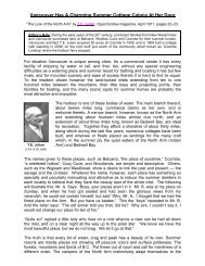
Palisade Lake – alpine reservoir<br />
Water monitoring and forecasting will provide essential data to forecast<br />
water supply quantities. Currently the watersheds provide approximately<br />
400 million cubic meters of drinking water to the region, which represents<br />
21 percent of the mean annual inflow. Water quality is continuously<br />
assessed at various locations throughout the watersheds to evaluate the<br />
effectiveness of management strategies.<br />
Seymour River – hydrometric Station<br />
A series of weather, hydrometric, and sediment monitoring stations within<br />
the watersheds provide valuable information for watershed management<br />
decision-making. Weather stations measure rainfall and snow<br />
accumulations. The maintenance of long-term weather data is important to<br />
evaluate potential impacts from climate change. Hydrometric stations<br />
provide information on water inflow to the reservoirs, sediment input from<br />
various sub-drainages within the watersheds, and early warning of high<br />
turbidity events. Sediment stations characterize water quality conditions<br />
and assist in determining if mitigation measures are warranted. Periodic<br />
water samples from various locations in the watersheds are also analyzed<br />
for microorganisms that may provide risk to water quality.<br />
2. Forest Ecosystem <strong>Management</strong><br />
Objective: Minimize the amount of human induced disturbances to the<br />
forest ecosystem.<br />
The forest ecosystem will be conserved to ensure that the complexities,<br />
interactions and functions are sustained into the future that will maintain<br />
biodiversity and provide for ecosystem services. In addition, the forest<br />
ecosystem regulates runoff and minimizes soil erosion.<br />
Conserving forest ecosystems throughout the watersheds supports the<br />
Green Zone Strategy, Livable Region Strategic <strong>Plan</strong> by maintaining<br />
important ecological functions for habitats and biodiversity. Other<br />
W ATERSHED M ANAGEMENT P LAN 6
watershed resources influenced by the forest ecosystems include aquatic<br />
ecosystems, fish, wildlife, sensitive areas and cultural sites. These<br />
stewardship values are important both regionally and provincially due to<br />
the protected or endangered designation of some of resources. As an<br />
example, these forest ecosystems are managed to a standard that exceeds<br />
the habitat objectives, as described in the Spotted Owl <strong>Management</strong> <strong>Plan</strong> –<br />
Strategic Component. Provincial fish and wildlife strategies will be<br />
implemented in appropriate implementation plans<br />
The forests within the watersheds reflect a legacy of natural and human<br />
disturbances. Disturbances will be monitored as to their extent and impact<br />
to watershed resources. Ecosystem stressors and forest health will be<br />
monitored to provide early warning for assessment of whether any<br />
intervention is warranted. Pest management strategies will be coordinated<br />
with adjacent jurisdictions, including urban and recreation properties, and<br />
provincial forest and provincial park lands. The pest management<br />
implementation plan will consider appropriate integrated pest management<br />
strategies. For example, an appropriate strategy to maintain forest health is<br />
to conserve the complex interactions between organisms within the<br />
ecosystem. The need for intervention is not expected to be frequent and<br />
will consist of the following primary activities, among others:<br />
‣ increase the level of monitoring of a potential disturbance;<br />
‣ planting of deciduous and coniferous tree species to establish diverse<br />
healthy stands following a disturbance; and<br />
Capilano Reservoir<br />
‣ intensive insect trapping to control and monitor populations.<br />
3. Fire <strong>Management</strong><br />
Objective: Suppress wildfires only when and where necessary to ensure<br />
water quality, protect public safety and property, and maintain air quality.<br />
Although extensive wildfires are rare in the watershed, evidence exists of<br />
natural fires occurring in the warmer and drier zones located at low<br />
elevations in the watersheds. In contrast, the colder and wetter climatic<br />
zones located at higher elevations in the watersheds have minimal evidence<br />
of natural fires. The biogeoclimatic system of ecosystem classification<br />
characterizes this range in climatic conditions. The annual precipitation<br />
in the watersheds ranges from approximately 2000 mm to 5000 mm.<br />
Biogeoclimatic zones in the watersheds include Coastal Western Hemlock<br />
(CWH) Zone, Mountain Hemlock (MH) Zone and Alpine Tundra (AT)<br />
Zone representing regional climate and topographic conditions (see Map 2).<br />
The consequences of wildfires in the drier zones include risks to water<br />
quality, public safety and property, and air quality. Wildfires in the higher<br />
elevation zones pose minimal risks to the public and air quality. The fire<br />
management program will utilize the ecosystem classification by applying<br />
the appropriate management activities to the various zones.<br />
7 W ATERSHED M ANAGEMENT P LAN
Fire management encompasses a range of public values while considering<br />
ecosystem processes. Wildfires are recognized to play a positive role in<br />
minimizing the impacts of larger fires, creating habitat and influencing<br />
forest health. When appropriate, natural occurring wildfires will not be<br />
suppressed during appropriate periods and in suitable zones within the<br />
watersheds.<br />
The fire management program will consist of the following activities:<br />
‣ calculation of fire weather indices and monitoring of ventilation<br />
indices;<br />
‣ prevention and detection of fires;<br />
‣ suppression of fires when and where appropriate, will rely more upon<br />
aerial attack rather than methods requiring road access;<br />
‣ monitoring wildfire activity and any potential effect on water quality;<br />
and<br />
‣ evaluation and development of fire management strategies.<br />
Wildfires will be allowed to occur in suitable portions of the MH Zone<br />
during periods of appropriate fire weather and ventilation indices. The<br />
southern portions of the MH Zone that are adjacent to recreation facilities<br />
are not suitable for allowing wildfires to occur. Over the term of this <strong>Plan</strong>,<br />
information on fire behaviour in forest types located in the watersheds will<br />
be developed to move the management regime towards allowing wildfires<br />
to occur in selected portions of the CWH Zone, Montane Very Wet<br />
Maritime Variant, and in higher zones as shown on Map 2. Memorandums<br />
of Understanding will be developed with other agencies to coordinate<br />
effective implementation of the fire management program.<br />
4. Erosion Control<br />
Objective: Minimize the impact of soil erosion on the quality of the water<br />
entering the water distribution system.<br />
Soil erosion occurs in the watersheds as a natural process and as a result of<br />
human disturbance. Sources of soil erosion are from landslides, stream<br />
banks and surface erosion, including some sources resulting from past<br />
harvesting and road construction. During winter storms, erosion of fine<br />
textured soils and organic matter may become suspended in the reservoir<br />
and impact water quality throughout the water supply system.<br />
Analysis of water monitoring data will identify any need for erosion control<br />
to protect water quality. Erosion control projects will include the following<br />
activities:<br />
‣ excavation of landslide deposits containing fine textured material that<br />
have the potential to be carried into the water supply reservoirs;<br />
‣ stabilization of stream banks where appropriate to minimize the rate of<br />
bank erosion;<br />
‣ decommissioning of roads<br />
W ATERSHED M ANAGEMENT P LAN 8
‣ re-vegetation of landslide scars, gully sidewalls and reservoir<br />
drawdown zones to minimize surface erosion; and<br />
‣ evaluation and development of erosion control strategies.<br />
Monitoring water quality and the rate of erosion after a project is completed<br />
will document its effectiveness.<br />
5. Road Network<br />
Objective: Reduce the amount of roads in the watersheds to a level<br />
consistent with the Goal and Principles of this <strong>Plan</strong>.<br />
Much of the 300-kilometer road network in the watersheds is a legacy of<br />
the discontinued sustained yield logging program that started in the 1960’s.<br />
Some of these roads exist on unstable terrain and require frequent<br />
maintenance. Portions of the road network are no longer necessary while<br />
the remaining are essential for vehicle access.<br />
The long-term road network will comprise of essential roads providing<br />
vehicle access to:<br />
Deactivated Road<br />
‣ water supply and water quality monitoring sites;<br />
‣ site developments for water system infrastructure as described in<br />
Section 6-Water System Infrastructure;<br />
‣ natural gas right-of-way and BC Hydro facilities in Coquitlam<br />
watershed; and<br />
‣ search and rescue requirements adjacent to Cypress Bowl Provincial<br />
Park.<br />
The road program is illustrated on Map 3 and will consist of the following:<br />
‣ Essential roads will be maintained to avoid the initiation of landslides<br />
and surface erosion.<br />
‣ Non-essential roads will be deactivated to minimize sources of erosion<br />
and reduce long-term maintenance costs.<br />
‣ Discontinued roads that are already overgrown with vegetation and<br />
may not require activity.<br />
Maintained Road<br />
For both long-term essential roads and non-essential roads that will be<br />
deactivated, annual audits and monitoring will occur to ensure that risks to<br />
water quality are minimized while access to water supply infrastructure is<br />
maintained.<br />
9 W ATERSHED M ANAGEMENT P LAN
W ATERSHED M ANAGEMENT P LAN 10
W ATERSHED M ANAGEMENT P LAN 11
6. Water System Infrastructure<br />
Objective: Provide infrastructure for the storage, transmission and<br />
treatment of the water supply while conserving watershed resources to the<br />
greatest extent possible.<br />
Cleveland Dam<br />
The water system infrastructure includes dams, reservoirs, water intakes,<br />
pipelines, water treatment facilities, buildings and roads as described in<br />
Section 5-Road Network. The dam and the reservoir in the Coquitlam<br />
watershed is the responsibility of BC Hydro. The development of<br />
infrastructure on watershed lands will be required to meet the overall Goal<br />
of providing clean, safe drinking water and is consistent with the guiding<br />
Principles of this <strong>Plan</strong>.<br />
To support the maintenance and upgrade of the system infrastructure, areas<br />
within the watersheds may be used for the following activities:<br />
‣ staging areas for the temporary and permanent storage of soils and<br />
construction materials;<br />
‣ constructing dams, water intakes, pipelines, water treatment facilities,<br />
and buildings;<br />
Seymour Falls Dam<br />
Coquitlam Reservoir –<br />
wood debris removal<br />
‣ seismic upgrading of the dams;<br />
‣ utilization of aggregate and other mineral resources in a manner<br />
consistent with the Goal, Principles and <strong>Management</strong> Strategies; and<br />
‣ providing road, helicopter and trail access to facilities.<br />
Environmental and social values associated with the watershed resources<br />
will be considered when infrastructure within the watershed is developed<br />
for water supply purposes. As an example, no fuel will be stored ondrainage<br />
in the watershed and impacts to vegetation will be minimized<br />
when infrastructure is developed. In addition, planning of developments<br />
will utilize an Archeological Overview Assessment and conform to the<br />
regulations in the Heritage Conservation Act. All infrastructure works will<br />
be subject to full public and regulatory review.<br />
7. Communication and Education<br />
Objective: Develop and maintain confidence and trust that the GVRD is<br />
managing the watershed resources in an environmentally responsible and<br />
cost-efficient manner.<br />
The GVRD will disseminate information on the watershed management<br />
program and provide opportunities for the public to become involved in<br />
watershed stewardship initiatives. A variety of opportunities will be<br />
provided to facilitate public involvement in the management of the<br />
watersheds.<br />
W ATERSHED M ANAGEMENT P LAN 12
The communication and education program will include the following<br />
activities:<br />
‣ public tours of the watersheds;<br />
‣ public review and input on implementation plans;<br />
‣ field trips for the public to view proposed management activities;<br />
‣ participation of community watershed stewardship groups;<br />
‣ guidelines to facilitate research in the watersheds; and<br />
‣ a watershed data and information web site on the internet.<br />
‣ GVRD education resources and programs.<br />
8. <strong>Watershed</strong> Security<br />
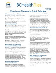
Objective: Reduce the risk from microbiological or chemical<br />
contamination and the risk of fires by only allowing access to persons<br />
conducting activities previously authorized by the GVRD.<br />
Public access will be granted through watershed tours, academic projects<br />
and other initiatives pre-approved by the Board. Controlling access into the<br />
watershed is strongly supported through public opinion polls.<br />
Security procedures are in place to minimize the risk of unauthorized entry<br />
into in the watersheds. The entrances to the watersheds are gated and each<br />
watershed is patrolled. Patrol persons provide a point of contact in the<br />
watersheds for emergencies, accidents and communication. Sanitary<br />
facilities will continue to be provided and maintained at all work sites in the<br />
watersheds.<br />
9. Emergency Preparedness<br />
Objective: Execute an emergency management program to minimize<br />
potential threats involving the watersheds and adjacent lands.<br />
The emergency management program will be based upon a foundation of<br />
threat identification, risk assessment and impact analysis. For example,<br />
portions of the watersheds experience landslides and wildfires that have a<br />
range of potential consequences to public safety, water quality and water<br />
supply infrastructure. In addition, an emergency procedure is in place to<br />
respond to unauthorized activities. The foundation of the emergency<br />
management program will be site specific to reflect the geography,<br />
topography and land uses in and adjacent to each watershed. The<br />
emergency management program will include the following activities:<br />
‣ produce a complete list of threats identified from potential hazards or<br />
perils;<br />
‣ conduct risk analysis to determine the likelihood of an occurrence;<br />
13 W ATERSHED M ANAGEMENT P LAN
‣ complete an impact analysis to describe the consequence of any event<br />
occurring;<br />
‣ develop a mitigation strategy to reduce the threat likelihood in a costefficient<br />
manner;<br />
‣ increase the level of preparedness with contingency and response<br />
planning; and<br />
‣ create a recovery plan to restore or continue the ability of the<br />
watersheds to meet their primary purpose.<br />
PLANNING PROCESS<br />
The watershed planning process involves the public, stakeholders, advisory<br />
committees, municipalities and government agencies. The watershed<br />
planning process will be on a recurring basis, with strategic plans prepared<br />
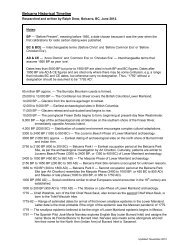
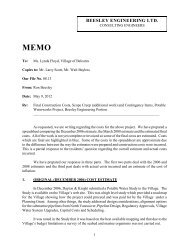
on a five year cycle and implementation plans prepared annually. Diagram<br />
A illustrates the planning process and the inter-relationship between the<br />
strategic planning and the implementation planning processes.<br />
This strategic <strong>Plan</strong> will be reviewed and revised based upon the trends<br />
shown in the annual reports. The revision process will commence 18<br />
months prior to the expiry of this <strong>Plan</strong>.<br />
This strategic <strong>Plan</strong> forms an integral part of the Drinking Water<br />
<strong>Management</strong> <strong>Plan</strong> (DWMP) which is also expected to be revised on a five<br />
year cycle. The DWMP will provide long-range strategies for the entire<br />
drinking water system, from the water supply source to the municipal water<br />
distribution system.<br />
W ATERSHED M ANAGEMENT P LAN 14
-<br />
Diagram A: <strong>Watershed</strong> <strong>Plan</strong>ning Process<br />
Strategic <strong>Plan</strong><br />
Review <strong>Plan</strong><br />
Principles<br />
Comprehensive 5-Year<br />
Report<br />
Five Year Cycle<br />
<strong>Management</strong> Strategy<br />
Evaluation<br />
Implementation Programs<br />
Five-Year Implementation <strong>Plan</strong>s<br />
Adaptive <strong>Management</strong><br />
Implementation Programs<br />
Annual Reports<br />
One Year Cycle<br />
<strong>Management</strong> Activities<br />
Evaluation<br />
Performance Measures<br />
Monitoring<br />
W ATERSHED M ANAGEMENT P LAN 15
ADAPTIVE MANAGEMENT<br />
The purpose of adaptive management is to develop improved techniques while conducting management<br />
activities, so the effectiveness and cost-efficiency will be improved for future activities. <strong>Watershed</strong><br />
management contains a level of uncertainty due to the complex ecosystem processes within the<br />
watersheds and to climate change. Monitoring and documenting the state of the watersheds will allow for<br />
an adaptive management approach to watershed planning. The adaptive management approach to<br />
watershed planning will include the following steps:<br />
‣ identify management issues by monitoring water quality and ecosystem disturbances;<br />
‣ initiate an activity to resolve each issue identified as warranting treatment;<br />
‣ treat the activity as a controlled experiment by monitoring and documenting the results; and<br />
‣ revise the techniques used in future activities based upon knowledge gained from monitoring to<br />
improve the implementation of future activities.<br />
FIVE-YEAR IMPLEMENTATION PLAN<br />
During the period of this strategic <strong>Plan</strong>, five-year implementation plans will be produced to describe the<br />
proposed management activities for each of the implementation programs. The five-year implementation<br />
plan will provide the necessary guidance to ensure that management activities will be implemented<br />
reflecting the management strategies described in this strategic <strong>Plan</strong>.<br />
The five-year implementation plan will be updated annually, to provide detailed maps and work schedules<br />
prioritizing the activities proposed for the next five years in the watersheds. Designs and prescriptions<br />
will be provided for the management activities proposed for implementation in each successive year. The<br />
five-year implementation plan will receive input from the public and advisory committees.<br />
ANNUAL REPORT<br />
An annual report will be prepared describing the state of the watersheds and providing documentation on<br />
the results of the various management activities in each implementation program. The annual report will<br />
summarize information identifying issues and will summarize the results of management activities that<br />
are designed to resolve issues in the watersheds. Every five years a comprehensive report will summarize<br />
trends and management activities associated with this <strong>Plan</strong>. The annual report will be prepared by staff<br />
with input provided by advisory groups and stakeholders. The annual report will be submitted to the<br />
GVRD Board.<br />
W ATERSHED M ANAGEMENT P LAN 16
GLOSSARY<br />
Adaptive <strong>Management</strong><br />
<strong>Plan</strong>ning and management strategies are modified frequently through<br />
“learning from experiences” and new scientific findings, in response to<br />
changing social, environmental, and economic expectations and demands.<br />
The process requires constant monitoring and analysis of the results of<br />
past actions to lead to new approaches and innovative decision-making.<br />
<strong>Management</strong> Practices<br />
A system of methods, measures, or practices designed to reserve, restore,<br />
enhance, avoid, or minimize deterioration of aquatic and terrestrial<br />
resources. <strong>Management</strong> Practices can use soft (e.g. planning) or hard<br />
approaches (engineering techniques) to achieve goals and objectives.<br />
Biodiversity<br />
The diversity of plants and animals and other living organisms in all their<br />
forms and levels of organization, including the diversity of genes, species,<br />
ecosystems, and the evolutionary and functional processes that link them.<br />
Biogeoclimatic Classification<br />
An ecological system that utilizes climate, vegetation, topography and<br />
soils data to produce a classification of ecosystems.<br />
Crown Leases<br />
Deactivated<br />
The District leases Crown lands from the Province for the purpose of<br />
water supply for a term of 999 years. The leases originate in 1927 for the<br />
Capilano and Seymour watersheds and 1942 for the Coquitlam<br />
watershed.<br />
Roads no longer required may be re-contoured to the natural side slope,<br />
cross ditched and/or have culverts and bridges removed.<br />
Drainage<br />
On-drainage is used to distinguish those lands that drain into the three<br />
main water supply storage reservoirs. GVRD also has jurisdiction over<br />
several off-drainage areas that do not drain into the reservoirs.<br />
Ecosystem<br />
A spatially explicit unit of the environment that includes all organisms,<br />
along with all components of the abiotic environment within its<br />
boundaries.<br />
Ecosystem Integrity<br />
Maintaining the functionality of ecosystems and its components even if<br />
disturbed by human or natural causes.<br />
Ecosystem Services<br />
The services of ecological systems critical to the functioning of the<br />
Earth’s life-support system that contribute directly and indirectly to<br />
human welfare. Examples of ecological services include pollination; air<br />
and water purification; climate modification; drought and flood control;<br />
cycling of nutrients; and habitat.<br />
W ATERSHED M ANAGEMENT P LAN 17
Ecosystem Stressors<br />
A physical (e.g. drought), biological (e.g. insect outbreak), or chemical<br />
(e.g. acid rain) condition that negatively impacts ecosystems or its<br />
components.<br />
Environmental Stewardship<br />
Caring for and attending to the natural environment to ensure it is<br />
managed for future generations.<br />
Erosion<br />
Erosion of rock and soil generally occurring during storms with high<br />
precipitation. Examples of erosion include landslides, debris torrents,<br />
eroding stream banks and surface erosion.<br />
Forest Health<br />
Biotic and abiotic factors in the forest that are usually naturally occurring<br />
components of forest ecosystems. Biotic influences include fungi, insects,<br />
plants, other animals, bacteria and nematodes. Abiotic influences include<br />
frost, snow, fire, wind, drought, nutrients and human-caused injury.<br />
Forest Succession<br />
A forest develops overtime forming distinct growth stages (shrub/herb,<br />
young forest, old forest etc.) following a disturbance such as fire or<br />
landslide.<br />
Hazard<br />
Integrated Pest <strong>Management</strong><br />
A source of danger that could result in a consequence to the water system.<br />
A decision making process that uses a combination of techniques to<br />
suppress pests and that must include but is not limited to the following:<br />
planning and managing ecosystems to prevent organisms from becoming<br />
pests; identifying potential pest problems; monitoring populations of<br />
pests and beneficial organisms, pest damage and environmental<br />
conditions; using injury thresholds in making treatment decisions;<br />
reducing pest populations to acceptable levels using a combination of<br />
methods; and evaluating the effectiveness of treatments.<br />
Multiple Barrier Approach<br />
Peril<br />
State of the <strong>Watershed</strong><br />
A multiple barrier approach to minimize risks to drinking water includes;<br />
protecting the water source through a closed watershed; appropriate water<br />
treatment; trained certified water system operators; well-maintained and<br />
safe water distribution systems; and effective monitoring of water quality<br />
at each step from source to tap.<br />
An immediate danger that could result in a serious consequence to the<br />
water system.<br />
A report that provides a summary on the condition of the watershed,<br />
especially as it relates to water quality, ecosystem integrity,<br />
environmental stewardship, and public participation. The report outlines<br />
the results of watershed activities, documents natural and human<br />
disturbances, and identifies trends on the overall health of ecosystems.<br />
WATERSHED MANAGEMENT PLAN 18
<strong>Watershed</strong> <strong>Management</strong> <strong>Plan</strong><br />
The <strong>Watershed</strong> <strong>Management</strong> <strong>Plan</strong> is a strategic plan for the area<br />
contained within the Capilano, Seymour, and Coquitlam watersheds that<br />
are used for water supply purposes. The watershed is determined from<br />
the height of land that provides the drainage basin contributing water,<br />
organic matter, dissolved nutrients, and sediments to a network of streams<br />
flowing into the Capilano, Seymour, and Coquitlam reservoirs. The<br />
<strong>Watershed</strong> <strong>Management</strong> <strong>Plan</strong> provides management strategies to achieve<br />
measurable objectives that support GVRD’s overall goal in this<br />
<strong>Watershed</strong> <strong>Management</strong> <strong>Plan</strong> is “<strong>Watershed</strong>s that provide clean, safe<br />
water and are managed and protected as natural assets of the highest<br />
importance to the Greater Vancouver Region”. The management<br />
strategies are based upon natural, human and management sciences.<br />
W ATERSHED M ANAGEMENT P LAN 19
REFERENCES<br />
‣ Acres International Limited, 1993. GVWD <strong>Watershed</strong> Ecological Inventory Pilot Study.<br />
‣ Acres International Limited, 1997. GVRD <strong>Watershed</strong> Ecological Inventory Program Methodology Report.<br />
‣ Acres International Limited, 1999. Annex to the Analysis Report.<br />
‣ Allaby, Michael, 1998. Dictionary of Ecology.<br />
‣ Boyce, M.S. Haney, A. 1997. Ecosystem <strong>Management</strong>, Applications for Sustainable Forest and Wildlife<br />
Resources.<br />
‣ Bunnell, F.L. Johnson, J.F. Policy and Practices for Biodiversity in Managed Forests, The Living Dance.<br />
‣ Compass Resource <strong>Management</strong> Ltd., 1999. Analysis Report: <strong>Management</strong> <strong>Plan</strong> #5 Greater Vancouver Water<br />
District.<br />
‣ Day, Chad (Chair) Regional Water Advisory Committee, 1999. Report of the GVRD Regional Water<br />
Advisory Committee (RWAC) on the Ecological Inventory Program, Analysis, and Annex Reports.<br />
‣ Department of Lands, 1924. Lease from Province of British Columbia.<br />
‣ Dunster, J. Dunster, K. 1996. Dictionary of Natural Resource <strong>Management</strong>.<br />
‣ Economic and Engineering Services, Inc. 1991. <strong>Watershed</strong> <strong>Management</strong> Evaluation and Policy Review.<br />
‣ Environment Canada and National Research Council, 1999. Hydrological and Hydraulic Modelling of Fine<br />
Sediment Transport in the Capilano <strong>Watershed</strong>.<br />
‣ Greater Vancouver Regional District, 1996. Creating Our Future.<br />
‣ Greater Vancouver Regional District, 1997. Livable Region Strategic <strong>Plan</strong>.<br />
‣ Greater Vancouver Regional District, 1997. Terms of Reference: <strong>Management</strong> <strong>Plan</strong> #5 Greater Vancouver<br />
Water District.<br />
‣ Greater Vancouver Regional District, 1998. Issues and Options Report: <strong>Management</strong> <strong>Plan</strong> #5 Greater<br />
Vancouver Water District.<br />
‣ Kohm, K.A. Franklin, J.F. Thomas, J.W. 1997. Creating a Forestry for the 21 st Century, The Science of<br />
Ecosystem <strong>Management</strong>.<br />
‣ Luoma, J.R. 1999. The Hidden Forest, The Biography of an Ecosystem.<br />
‣ Nature: Volume 387 no 6230, Macmillan Publishers Ltd. 1997, The Value of the World’s Ecosystem Services<br />
and Natural Capital.<br />
‣ Pearse, P.R. Kellerhals and E. Peterson. Scientific Review Panel, 1997. <strong>Plan</strong>ning for the <strong>Management</strong> of<br />
Greater Vancouver’s <strong>Watershed</strong>s.<br />
‣ Pearse, P.R. Kellerhals and E. Peterson. Scientific Review Panel, 1998. <strong>Management</strong> <strong>Plan</strong>ning for Greater<br />
Vancouver’s <strong>Watershed</strong>s: Data Base.arse, P.R. Kellerhals and E. Peterson. Scientific Review Panel, 1999.<br />
Toward a New <strong>Management</strong> <strong>Plan</strong> for Greater Vancouver’s <strong>Watershed</strong>s: Focusing on Objectives.<br />
‣ Smithsonian Insitution Monitoring and Assessment of Biodiversity Program, President’s Committee of<br />
Advisors on Science and Technology, 2001. Biodiversity Connecting with the Tapestry of Life.<br />
WATERSHED MANAGEMENT PLAN 20
‣ Thurber Engineering Ltd., 1993. Assessment of Turbidity-Generating Sediment Sources and Transport in the<br />
Capilano, Seymour and Coquitlam <strong>Watershed</strong>s.<br />
W ATERSHED M ANAGEMENT P LAN 21
<strong>Watershed</strong> <strong>Management</strong> <strong>Plan</strong><br />
For more information, contact:<br />
GVRD Policy and <strong>Plan</strong>ning Department<br />
4330 Kingsway<br />
Burnaby, B.C.<br />
V5H 4G8<br />
Tel: (604) 432-6375 Fax: (604) 436-6970<br />
Web site: www.gvrd.bc.ca<br />
Greater<br />
Vancouver<br />
Regional<br />
District