Continental Rifting Lecture Summary - Myweb @ CW Post
Continental Rifting Lecture Summary - Myweb @ CW Post
Continental Rifting Lecture Summary - Myweb @ CW Post

You also want an ePaper? Increase the reach of your titles
YUMPU automatically turns print PDFs into web optimized ePapers that Google loves.
GLY 47/511 - Plate Tectonics<br />
<strong>Continental</strong> Rifts <strong>Lecture</strong> <strong>Summary</strong><br />
<strong>Lecture</strong> on 2/21/12<br />
based principally on Chapter 3 in Frisch et al. (2011), and Sections 7.1-7.4 in Kearey et<br />
al. (2009)<br />
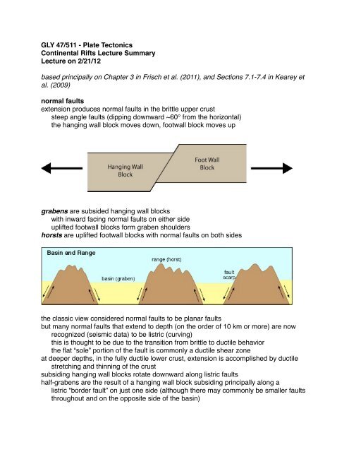
normal faults<br />
extension produces normal faults in the brittle upper crust<br />
steep angle faults (dipping downward ~60° from the horizontal)<br />
the hanging wall block moves down, footwall block moves up<br />
grabens are subsided hanging wall blocks<br />
with inward facing normal faults on either side<br />
uplifted footwall blocks form graben shoulders<br />
horsts are uplifted footwall blocks with normal faults on both sides<br />
the classic view considered normal faults to be planar faults<br />
but many normal faults that extend to depth (on the order of 10 km or more) are now<br />
recognized (seismic data) to be listric (curving)<br />
this is thought to be due to the transition from brittle to ductile behavior<br />
the flat “sole” portion of the fault is commonly a ductile shear zone<br />
at deeper depths, in the fully ductile lower crust, extension is accomplished by ductile<br />
stretching and thinning of the crust<br />
subsiding hanging wall blocks rotate downward along listric faults<br />
half-grabens are the result of a hanging wall block subsiding principally along a<br />
listric “border fault” on just one side (although there may commonly be smaller faults<br />
throughout and on the opposite side of the basin)
foot wall blocks experience isostatic uplift because weight is being removed<br />
as hanging wall blocks are slowly removed from them<br />
foot wall blocks flex upwards since only one end is rising<br />
rift geometry<br />
active rifts: (lithosphere extension driven by upwelling asthenosphere)<br />
driven by mantle upwelling (e.g., hotpsot mantle plume)<br />
wide area of uplift and thinning of mantle lithosphere<br />
! (in comparison to width of faulting and crustal thinning)<br />
passive rifts: (asthenosphere upwelling driven by lithospheric extension)<br />
driven by extension of lithosphere (due to plate motions, etc.)<br />
narrow zone of lithospheric thinning and uplift<br />
note: uplift is due to the replacement of lithosphere by asthenosphere (less dense)<br />
symmetric rifting:<br />
narrow graben structure with similar degree of inward facing normal faulting on both<br />
sides<br />
asymmetric rifting:<br />
wide zone of faulting underlain be a regional detachment (decollement) surface<br />
individual listric normal faults merge into the basal decollement
the decollement is a ductile shear zone which slices down through the lower crust<br />
and lithospheric mantle<br />
rift volcanism<br />
magma produced by decompression melting<br />
hot asthenosphere moves closer to surface as lithosphere thins<br />
bimodal: basalt - rhyolite (little intermediate lava)<br />
some tholeitic basalt (high percent melting at shallow depth)<br />
alkaline lavas characteristic (low percent melting at greater depth)<br />
narrow continental rifts<br />
probably form in thick, cool (strong) lithosphere<br />
can potentially proceed to split, forming new midocean ridge and ocean basin<br />
Rhine Graben<br />
part of a larger western European graben system<br />
symmetric graben structure<br />
thinned crust in central graben area<br />
minor volcanism (only 2 volcanic centers)<br />
early extension in upper portion (SW) of Upper Rhine Graben<br />
later active extension in lower (NE) portion of Upper Rhine Graben<br />
latest extension in the Lower Rhine Embayment resulting from a counterclockwise<br />
! rotation of the extension direction<br />
! causing some sinistral (left-lateral) shearing of Upper Rhine Graben<br />
Upper Rhine Graben and Bresse Graben offset by system of strike-slip faults<br />
! that act in aggregate like a sinistral transform fault offsetting spreading<br />
! segments of a midocean ridge<br />
East African Rift System<br />
represents the third arm of a triple junction<br />
the other 2 arms are the Gulf of Aden (midocean ridge)<br />
and the Red Sea (newly formed ocean basin - actual ocean crust in middle)<br />
4 parts:<br />
Afar Triangle (Afar Depression)<br />
Main Ethiopian Rift (East African Graben)<br />
Western Rift (Central African Graben)<br />
Eastern Rift (Kenya or Gregory Rift)<br />
the Western and Eastern Rifts are like overlapping spreading centers<br />
northern part of the rift system produces voluminous vulcanism<br />
especially in Afar Triangle approaching triple junction<br />
flood basalts erupt from fissures in the Afar Triangle<br />
there may be a mantle plume beneath Ethiopia<br />
the rift is segmented, with offsets of central volcanic zones along the rift axis, notably<br />
in the Main Ethiopian Rift into the Afar Triangle<br />
(not unlike offset midocean ridge spreading centers)<br />
many of these rift segments are asymmetric with most subsidence along major border<br />
faults on one side of the rift (half graben structure)<br />
low seismic velocities under the Main Ethiopian/Afar indicates low density, hot, rising<br />
asthenosphere under the rift
gravity lows across the Western and Eastern rifts also indicate very thin lithosphere<br />
(low density asthenosphere replacing denser lithosphere)<br />
long wavelength gravity anomalies (mathematically filtering out small scale variations)<br />
show a circular low over the Ethiopia and an elongate gravity trough along eastern<br />
Africa to the south, indicating thinned lithosphere (hot, low-density asthenosphere<br />
replacing cooler, denser lithosphere)<br />
seismic data (focal plane solutions) indicate dominant normal faulting with NE-SW<br />
strikes, paralleling the Main Ethiopian Rift but changing to NW-SE in coastal<br />
sections of the Afar Triangle, parallel to spreading direction in the Red Sea<br />
some deep basins in coastal Afar Triangle may actually be composed of basaltic<br />
(oceanic) crust<br />
Red Sea rifting has transitioned to drifting<br />
new ocean crust now forms in central basins in the Red Sea<br />
these deep basins are 2 to 2.5 km deep, floored by basalt<br />
no midocean ridge feature because ocean crust area not wide enough<br />
most of Red sea underlain by stretched/thinned continental crust<br />
the Arabian peninsula has broken away from and is drifting northward away from<br />
Africa due to seaflor spreading in the Red Sea and Gulf of Aden<br />
the Red Sea spreading center ends in a sinistral transform fault system that extends<br />
up through the Gulf of Aqaba and up the Jordan Graben (Jordan River, Dead Sea)<br />
along which the Arabian plate moves northward<br />
Newark Rift Basin<br />
the Newark Basin is one of a series of half-graben rift basins in present-day eastern<br />
North America that were active in the Late Triassic-Early Jurassic, around 225-180<br />
m.y. ago prior to the separation of Laurasia from Gondwana with the formation of<br />
new ocean crust between North America and Africa beginning about 170 m.y. ago<br />
the Newark basin subsided and tilted downward towards the Ramapo fault which<br />
separates the basin (hanging wall block) from the uplifted footwall (Hudson<br />
Highlands) composed of ~1 b.y. old gneiss, exposed by erosion of younger<br />
overlying strata<br />
the basin is filled with Triassic-Jurassic sedimentary strata which are inter-layered<br />
toward the top with 3 major basaltic lava flows, as well as a large sill intrusion<br />
(Palisade Sill)<br />
wide continental rifts<br />
probably form in thin, hot (weak) lithosphere<br />
may produce large amounts of extension over a long period without rifting completely<br />
through to form a new ocean basin<br />
Basin and Range<br />
broad area of extension & crustal thinning<br />
! 500 - 800 km wide<br />
! 250 - 300 km of extension during last 16 m.y.<br />
average crustal thickness ~30 km<br />
! adjacent Colorado Plateau is 50 km<br />
Basin & Range originally thicker still<br />
(was site of late Cretaceous thrusting and crustal thickening)
extend from the east side of the Sierra Nevada to the Colorado Plateau, Rocky<br />
Mountains and as far as the Gran Teton Range in NW Wyoming<br />
the structures include full grabens and sequences of half grabens rotating<br />
downward on listric faults<br />
the upper (brittle) crust is variably thinned, even though the total crustal thickness is<br />
fairly consistently about 30 km<br />
NW-SE shearing along the California coast continues to the boundary region<br />
between the Sierra Nevada and the western Basin and Range<br />
motions become westward extension on normal faults in and across the Basin<br />
and Range<br />
Basin & Range extension is probably caused by the relative motion between the<br />
Pacific and North American plates (i.e., it is not perfectly transform motion)<br />
the extended region was originally thickened during Mesozoic Era compressional<br />
tectonics<br />
the regular size and spacing of the basins and ranges contrasts with studies that<br />
indicate variable total crustal thickness down to the Moho of from 15-20 km up to<br />
40 km - so extension has not been uniform across the region<br />
low angle normal faults (normal faults should have steep dips) act as detachment<br />
surfaces<br />
in places they extend from the surface to middle and lower crustal depths, perhaps<br />
all the way through the crust (30 km)<br />
in places middle or lower crustal rocks have been exposed as<br />
metamorphic core complexes: brittle upper crustal rocks (hanging wall blocks)<br />
directly overlying lower crustal mylonites (decollement footwall rocks) showing<br />
ductile shearing, or the upper crustal rocks have been removed by faulting<br />
entirely<br />
the detachment fault (decollement) is a low angle normal fault<br />
these have been quite controversial, because rock shouldnʼt be able to slide<br />
down these low angle ramps, but there is evidence to indicate that they did<br />
commonly the exposed mylonite/ductile shear zone is bowed up (isostatic uplift due<br />
to local removal of overlying rocks)<br />
ultimately, continental rifting can lead to the breakup of a continent and the formation of<br />
a new ocean basin<br />
the edges of the 2 new continents will bear the marks of rifting and its aftermath as an<br />
evolving passive margin