Ride safely - Wisconsin Department of Tourism
Ride safely - Wisconsin Department of Tourism
Ride safely - Wisconsin Department of Tourism

You also want an ePaper? Increase the reach of your titles
YUMPU automatically turns print PDFs into web optimized ePapers that Google loves.
9JUST THE FACTS<br />
22 Visit travelwisconsin.com<br />
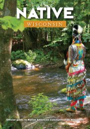
Chippewa County<br />
ATV Trails<br />
Chippewa County<br />
DISTANCE: 15 miles.<br />
DIFFICULTY: Easy to moderate.<br />
TRAILHEAD LOCATION(S): The eastern<br />
trailhead is located about 4.5 miles<br />
west <strong>of</strong> Holcombe on Cty M. The western<br />
trailhead is located about 8 miles<br />
northeast <strong>of</strong> Bloomer on 153rd St.<br />
SEASON: May 1 to November 15.<br />
OTHER TRAILS IN THIS REGION:<br />
Eau Claire County ATV Trails, Clark<br />
County ATV Trails<br />
NOTE: Stay on the trail; ATV routes are<br />
well marked. There are no services on<br />
the trail, but some businesses can be<br />
accessed along roads marked as ATV<br />
routes.<br />
CAUTION: The trail crosses the Ice Age<br />
Trail, which is <strong>of</strong>f limits to ATVs. Watch<br />
for large rocks in the middle <strong>of</strong> the trail<br />
and standing water after it rains.<br />
FEES: None.<br />
AREA ATTRACTIONS: Brunet Island<br />
State Park, Ice Age National Trail,<br />
Chippewa Moraine Interpretive Center.<br />
LEGEND: For a complete listing <strong>of</strong> all<br />
icons, see page 4.<br />
FOR MORE INFORMATION:<br />
Chippewa County <strong>Tourism</strong><br />
866/723-0331 or 715/726-7880<br />
www.chippewacounty.com<br />
Chippewa Falls Area Chamber <strong>of</strong><br />
Commerce<br />
866/723-0331 or 715/723-0331<br />
www.chippewachamber.org<br />
ERIC SKOGMAN<br />
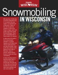
The hills, valleys and challenging terrain<br />
<strong>of</strong> northern Chippewa County<br />
were created by the action <strong>of</strong> glaciers<br />
many thousands <strong>of</strong> years ago.<br />
This glacial topography is what makes this<br />
area ideal for ATV riding.<br />
The Chippewa County<br />
ATV Trail rambles<br />
through a scattered<br />
string <strong>of</strong> the county’s<br />
33,000 acres <strong>of</strong> county<br />
forestland. Even though the<br />
trail here is short – 15 miles -<br />
you’ll be challenged with steep<br />
hills and valleys. Winding past small lakes<br />
and beaver ponds, the trail is an open door<br />
to spectacular vistas and abundant wild<br />
life.<br />
Beginning at the western trailhead,<br />
you’ll ride down a gravel road for about<br />
five miles on a swing north <strong>of</strong> Burnt<br />
Wagon Lake. The road winds east, then<br />
north toward Bass Lakes where you can<br />
stop and stretch your legs. A picnic table<br />
and newly built restrooms, funded by ATV<br />
registration money, are available. After a<br />
brief respite, hop back on your quad and<br />
continue north. The road turns into an<br />
ATV-only trail. The compacted surface provides<br />
ample traction in all kinds <strong>of</strong> conditions.<br />
A mile north <strong>of</strong> Bass Lakes, the trail<br />
crosses the Ice Age National Scenic Trail<br />
(800/227-0046 or 608/663-8278,<br />
www.iceagetrail.org). The Ice Age Trail is<br />
unique to <strong>Wisconsin</strong>, tracing the southernmost<br />
advance <strong>of</strong> the last <strong>Wisconsin</strong> glacier<br />
some 12,000 years ago. The 1,000-mile Ice<br />
Age Trail starts at Potawatomi State Park in<br />
Sturgeon Bay, runs south through the<br />
Northern and Southern Units <strong>of</strong> the Kettle<br />
Moraine State Forests, swings west<br />
through Madison, then northwest through<br />
<strong>Wisconsin</strong> Dells and Eau Claire to it terminus<br />
at Interstate Park near St. Croix Falls. It<br />
is a backpacker’s dream; but ATVs are not<br />
allowed.<br />
After crossing the Ice Age Trail, you’ll<br />
swing northeast around Dorothy Lake. The<br />
trail winds up and down hills and passes<br />
several wetlands. Heading north toward<br />
Cty M, it gets a little rockier with loose