Regions and Landforms in Arkansas - Arkansas Geological Survey
Regions and Landforms in Arkansas - Arkansas Geological Survey
Regions and Landforms in Arkansas - Arkansas Geological Survey

You also want an ePaper? Increase the reach of your titles
YUMPU automatically turns print PDFs into web optimized ePapers that Google loves.
EWS-03<br />
STATE OF ARKANSAS<br />
ARKANSAS GEOLOGICAL SURVEY<br />
BEKKI WHITE, DIRECTOR AND STATE GEOLOGIST<br />
_____________________________________________________________________<br />
EDUCATIONAL WORKSHOP SERIES 03<br />
_____________________________________________________________________<br />
<strong>Regions</strong> <strong>and</strong> L<strong>and</strong>forms <strong>in</strong> <strong>Arkansas</strong><br />
Angela Ch<strong>and</strong>ler<br />
Little Rock, <strong>Arkansas</strong><br />
2009
Acknowledgments<br />
This laboratory manual is written for <strong>Arkansas</strong> teachers study<strong>in</strong>g earth science.<br />
This was also written with the <strong>Arkansas</strong> Science Curriculum <strong>in</strong> m<strong>in</strong>d so that<br />
students can meet the requirements <strong>and</strong> goals set for their age groups. Various<br />
staff at the <strong>Arkansas</strong> <strong>Geological</strong> <strong>Survey</strong> contributed material to this manual.<br />
For <strong>in</strong>formation related to this manual please contact Angela Ch<strong>and</strong>ler:<br />
501-683-0111<br />
<strong>Arkansas</strong> <strong>Geological</strong> <strong>Survey</strong><br />
3815 W Roosevelt Rd<br />
Little Rock, AR 72204<br />
501-296-0877<br />
www.geology.ar.gov
Table of Contents<br />
<strong>Regions</strong> <strong>and</strong> L<strong>and</strong>forms of <strong>Arkansas</strong>………………………………………..1<br />
Topographic Map Read<strong>in</strong>g………………………………………………….13<br />
Interpretation of Streams <strong>and</strong> L<strong>and</strong>forms…………………………………19
STATE OF ARKANSAS<br />
Mike Beebe, Governor<br />
<strong>Arkansas</strong> <strong>Geological</strong> <strong>Survey</strong><br />
Bekki White, State Geologist <strong>and</strong> Director<br />
COMMISSIONERS<br />
Dr. Richard Cohoon, Chairman…………………………Russellville<br />
William Willis, Vice Chairman…………………………...Hot Spr<strong>in</strong>gs<br />
David J. Baumgardner…………………………………...Little Rock<br />
Brad DeVazier…………………………………………….Forrest City<br />
Keith DuPriest……………………………………………..Magnolia<br />
Qu<strong>in</strong> Baber…………………………………………………Benton<br />
David Lumbert……………………………………………..Little Rock<br />
Little Rock, <strong>Arkansas</strong><br />
2009
<strong>Regions</strong> <strong>and</strong> L<strong>and</strong>forms <strong>in</strong> <strong>Arkansas</strong><br />
Introduction<br />
A l<strong>and</strong>form is def<strong>in</strong>ed as any physical, recognizable form or feature of the Earth’s<br />
surface, hav<strong>in</strong>g a characteristic shape, <strong>and</strong> produced by natural causes<br />
(Glossary of Geology, Third Edition, 1987). <strong>Arkansas</strong> conta<strong>in</strong>s a variety of<br />
l<strong>and</strong>forms – from hilly l<strong>and</strong>scapes <strong>and</strong> ridges <strong>and</strong> valleys to nearly flat terraced<br />
pla<strong>in</strong>s. The present day l<strong>and</strong>forms <strong>in</strong> <strong>Arkansas</strong> are a result of the actions of past<br />
geologic processes, such as weather<strong>in</strong>g <strong>and</strong> erosion that cont<strong>in</strong>ue to the present<br />
day <strong>and</strong> the action of streams <strong>and</strong> rivers.<br />
L<strong>and</strong>forms can be classified as depositional or erosional. Depositional l<strong>and</strong>forms<br />
are those that have been deposited by water <strong>in</strong> the form of streams, rivers or<br />
oceans. These types of l<strong>and</strong>forms, called alluvium <strong>and</strong> terrace deposits are<br />
usually unconsolidated (not rock) <strong>and</strong> consist of s<strong>and</strong>, silt, clay <strong>and</strong> gravel.<br />
Erosional l<strong>and</strong>forms are those carved by the erosive forces of water, ice, <strong>and</strong><br />
w<strong>in</strong>d. These l<strong>and</strong>forms <strong>in</strong>clude mounta<strong>in</strong>s <strong>and</strong> plateaus, are generally made up<br />
of rock <strong>and</strong> are controlled by the geology of the area.<br />
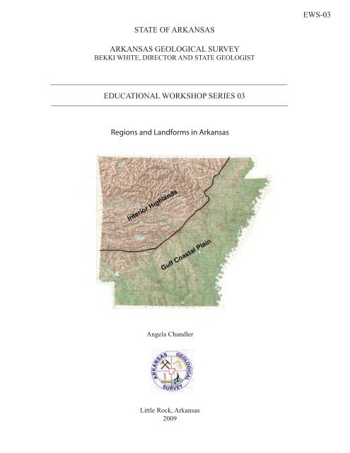
<strong>Arkansas</strong> is divided topographically <strong>in</strong>to two major regions along a northeastsouthwest<br />
trend<strong>in</strong>g “fall l<strong>in</strong>e”. This imag<strong>in</strong>ary l<strong>in</strong>e divides resistant sedimentary<br />
Paleozoic rocks (erosional l<strong>and</strong>forms) of the Interior Highl<strong>and</strong>s from<br />
unconsolidated sediments (depositional l<strong>and</strong>forms) of the Gulf Coastal Pla<strong>in</strong>.<br />
Notice the contrast<strong>in</strong>g l<strong>and</strong>form patterns.<br />
1
<strong>Arkansas</strong> is further divided <strong>in</strong>to five physiographic regions as seen below.<br />
Ozark Plateaus<br />
The Ozark Plateaus region sits on the edge of a broad, asymmetrical dome (or<br />
uplift), with the center of the dome (oldest rocks; Precambrian basement) located<br />
<strong>in</strong> the St. Francis Mounta<strong>in</strong>s of southeast Missouri (see map on next page). The<br />
rock formations dip gently away from this area <strong>in</strong> all directions. The Ozarks of<br />
northern <strong>Arkansas</strong> form the southern flank of this dome.<br />
This part of the state was periodically covered by a shallow mar<strong>in</strong>e sea from<br />
Ordovician through Mississippian geologic periods. Mostly carbonate rocks such<br />
as limestone <strong>and</strong> dolostones were deposited at this time. After the sea<br />
regressed dur<strong>in</strong>g the Pennsylvanian period, mostly s<strong>and</strong>stones <strong>and</strong> shales were<br />
deposited. The rocks <strong>in</strong> the Ozarks are only very weakly deformed <strong>and</strong> generally<br />
flat ly<strong>in</strong>g. The Ozarks have been deeply dissected by stream erosion form<strong>in</strong>g<br />
erosional mounta<strong>in</strong>s. Streams display a dendritic dra<strong>in</strong>age pattern.<br />
The Ozarks can be divided <strong>in</strong>to 3 plateaus (broad, flat-topped areas) that are<br />
separated from each other by steep slopes.<br />
1) Salem Plateau – capped by Ordovician age rocks, mostly dolostone<br />
2) Spr<strong>in</strong>gfield Plateau – capped by Mississippian age rocks, mostly limestone<br />
3) Boston Mounta<strong>in</strong>s Plateau – capped by Pennsylvanian age rocks, mostly<br />
s<strong>and</strong>stone<br />
2
The plateaus become higher <strong>in</strong> elevation <strong>and</strong> expose younger rocks from north to<br />
south <strong>in</strong> <strong>Arkansas</strong>. Refer to raised relief map to see plateau surfaces.<br />
L<strong>and</strong>forms <strong>in</strong> this region<br />
The Ozark Region consists of three plateau surfaces that conta<strong>in</strong> mostly canyons<br />
(called hollows), mounta<strong>in</strong>s, ridges, plateaus <strong>and</strong> valleys. Isl<strong>and</strong>s are present <strong>in</strong><br />
Beaver <strong>and</strong> Greers Ferry Lake <strong>and</strong> along the White River. One named prairie is<br />
present <strong>in</strong> the Diamond City area.<br />
Karst l<strong>and</strong>forms are also present <strong>in</strong> the Ozark Plateaus Region. Karst is a type<br />
of topography that is formed on limestone, gypsum <strong>and</strong> other rocks by dissolution<br />
<strong>and</strong> that is characterized by s<strong>in</strong>kholes, caves <strong>and</strong> underground dra<strong>in</strong>age. A<br />
majority of the region is made up of limestone <strong>and</strong> dolostone <strong>and</strong> conta<strong>in</strong>s caves,<br />
s<strong>in</strong>kholes <strong>and</strong> disappear<strong>in</strong>g streams.<br />
Refer to the follow<strong>in</strong>g quadrangles for l<strong>and</strong>forms <strong>in</strong> the Ozarks: Alread, Beaver,<br />
Boxley, Brownsville, Cave City Cotter, Delaney, Diamond City, Eureka Spr<strong>in</strong>gs,<br />
Fairfield Bay, Fiftysix, Hasty, Melbourne, Norfork Dam South, Onia, Rea Valley,<br />
Sylamore <strong>and</strong> War Eagle.<br />
Map of Ozark Dome <strong>and</strong> plateau surfaces <strong>in</strong> northern <strong>Arkansas</strong>.<br />
3
<strong>Arkansas</strong> River Valley<br />
The <strong>Arkansas</strong> River Valley represents the northern extent of the Ouachita<br />
orogenic (mounta<strong>in</strong> build<strong>in</strong>g) system <strong>in</strong> <strong>Arkansas</strong> (refer to physiographic regions<br />
map). This part of the state was also covered by a shallow sea from the<br />
Ordovician to Mississippian geologic periods. Dur<strong>in</strong>g the Mississippian <strong>and</strong><br />
Pennsylvanian periods this region was a deep bas<strong>in</strong> collect<strong>in</strong>g sediment from the<br />
surround<strong>in</strong>g area to form s<strong>and</strong>stone <strong>and</strong> shale. Low-ly<strong>in</strong>g swamps developed<br />
dur<strong>in</strong>g this time as well.<br />
Once flat-ly<strong>in</strong>g, these Pennsylvanian sedimentary rocks have been compressed<br />
<strong>in</strong>to well developed east-west trend<strong>in</strong>g open folds (anticl<strong>in</strong>es <strong>and</strong> syncl<strong>in</strong>es) <strong>and</strong><br />
faults, which gradually dim<strong>in</strong>ish northward <strong>in</strong>to the Ozark Plateau Region.<br />
The <strong>Arkansas</strong> River Valley is a low-ly<strong>in</strong>g region surround<strong>in</strong>g the valley of the<br />
<strong>Arkansas</strong> River <strong>and</strong> its major tributaries. The highest po<strong>in</strong>t <strong>in</strong> <strong>Arkansas</strong> (Mount<br />
Magaz<strong>in</strong>e – 2753 ft.) is found among several mounta<strong>in</strong> ridges that rise above the<br />
lowl<strong>and</strong>s <strong>in</strong> the southern portion of the river valley. The mounta<strong>in</strong> ridges are<br />
separated by broad valleys.<br />
L<strong>and</strong>forms <strong>in</strong> this region<br />
The <strong>Arkansas</strong> River Valley conta<strong>in</strong>s mostly mounta<strong>in</strong>s, ridges <strong>and</strong> valleys<br />
although some isl<strong>and</strong>s <strong>and</strong> swamps are present near the <strong>Arkansas</strong> River <strong>and</strong> its<br />
tributaries. Refer to the follow<strong>in</strong>g quadrangles for these l<strong>and</strong>forms: Adona,<br />
Dardanelle, Chickalah Mounta<strong>in</strong> East, Blue Mounta<strong>in</strong>, Blue Mounta<strong>in</strong> Dam,<br />
Magaz<strong>in</strong>e, Fort Smith <strong>and</strong> Van Buren.<br />
Ouachita Mounta<strong>in</strong>s<br />
The Ouachita Mounta<strong>in</strong> Region (refer to physiographic regions map) conta<strong>in</strong>s<br />
thick sequences of sedimentary rocks deposited <strong>in</strong> a deep ocean bas<strong>in</strong> that have<br />
been uplifted <strong>and</strong> compressed northward <strong>in</strong>to east-west trend<strong>in</strong>g complex folds<br />
(anticl<strong>in</strong>es <strong>and</strong> syncl<strong>in</strong>es) <strong>and</strong> thrust faults due to a major orogenic (mounta<strong>in</strong><br />
build<strong>in</strong>g) process called the Ouachita Orogeny. The most <strong>in</strong>tensely deformed<br />
area is <strong>in</strong> the central portion of the fold belt.<br />
This region consists of a series of sharp ridges, mostly east-west trend<strong>in</strong>g <strong>and</strong><br />
often buckled <strong>and</strong> distorted, separated by narrow to broad valleys. Streams<br />
display a trellis dra<strong>in</strong>age pattern due to the geologic structure <strong>in</strong> this region.<br />
L<strong>and</strong>forms <strong>in</strong> this region<br />
The Ouachita Mounta<strong>in</strong> Region conta<strong>in</strong>s mounta<strong>in</strong>s, canyons, valleys, ridges <strong>and</strong><br />
p<strong>in</strong>nacles. Some isl<strong>and</strong>s are present <strong>in</strong> Lake Ouachita. Refer to the follow<strong>in</strong>g<br />
4
quadrangles for these l<strong>and</strong>forms: Crystal Spr<strong>in</strong>gs, Founta<strong>in</strong> Lake, Hamilton <strong>and</strong><br />
P<strong>in</strong>nacle Mounta<strong>in</strong>.<br />
Mississippi River Alluvial Pla<strong>in</strong><br />
The Mississippi River Alluvial Pla<strong>in</strong> (refer to physiographic regions map) conta<strong>in</strong>s<br />
unconsolidated sediment such as s<strong>and</strong>, silt, clay, loess (silt deposited by w<strong>in</strong>d)<br />
<strong>and</strong> gravel that was deposited by the Mississippi River <strong>and</strong> its tributaries from<br />
around 5 million years ago to present day. Around 1.5 million years ago, meltwater<br />
from glaciers to the north provided large amounts of water <strong>and</strong> sediment to<br />
the Mississippi River. At this time the Mississippi River eroded a deep valley<br />
west of Crowley’s Ridge while the Ohio River eroded a valley east of Crowley’s<br />
Ridge (Guccione, 1993). Eventually the Mississippi River cut through Crowley’s<br />
Ridge near Cairo Ill<strong>in</strong>ois, captured the Ohio River <strong>and</strong> now flows on the east side<br />
of Crowley’s Ridge.<br />
This region is a relatively level pla<strong>in</strong> with elevations vary<strong>in</strong>g between 100-300<br />
feet except for Crowley’s Ridge with some of its highest po<strong>in</strong>ts reach<strong>in</strong>g 400-560<br />
feet.<br />
L<strong>and</strong>forms <strong>in</strong> this region<br />
The Mississippi River Alluvial Pla<strong>in</strong> is a pla<strong>in</strong> that conta<strong>in</strong>s swamps, prairies,<br />
isl<strong>and</strong>s <strong>and</strong> one ridge – Crowley’s Ridge. Refer to the follow<strong>in</strong>g quadrangles for<br />
these l<strong>and</strong>forms: De Valls Bluff, Des Arc East, Geridge, Lonoke <strong>and</strong> Walcott.<br />
West Gulf Coastal Pla<strong>in</strong><br />
The West Gulf Coastal Pla<strong>in</strong> is a south slop<strong>in</strong>g pla<strong>in</strong> of gently roll<strong>in</strong>g hills <strong>and</strong> can<br />
be divided <strong>in</strong>to two areas based on the<br />
age of the rocks.<br />
The area <strong>in</strong> green consists of Cretaceous<br />
s<strong>and</strong>, clay, gravel, marl, limestone, chalk<br />
<strong>and</strong> Quaternary s<strong>and</strong> <strong>and</strong> gravel. This<br />
area is characterized by gently southwarddipp<strong>in</strong>g<br />
sedimentary rocks deposited<br />
mostly <strong>in</strong> shallow mar<strong>in</strong>e water of the Gulf<br />
of Mexico that once extended <strong>in</strong>to<br />
<strong>Arkansas</strong>. Alluvium deposits from older<br />
<strong>and</strong> present day streams are common.<br />
The area <strong>in</strong> orange consists of Tertiary<br />
clays, s<strong>and</strong>s <strong>and</strong> silts with lignite deposits<br />
<strong>and</strong> Quaternary gravels, s<strong>and</strong>s <strong>and</strong> clays.<br />
This part of the state conta<strong>in</strong>s mostly early Tertiary rocks consist<strong>in</strong>g of s<strong>and</strong>s,<br />
silts <strong>and</strong> clays, deposited <strong>in</strong> streams, swamps <strong>and</strong> shallow mar<strong>in</strong>e water. Lignite<br />
beds occur throughout the sequence. Quaternary alluvium <strong>and</strong> terrace deposits<br />
5
are present from rivers <strong>in</strong> the area. Underneath the Tertiary deposits are the<br />
s<strong>and</strong>s, gravels, limestones, chalks <strong>and</strong> marls seen <strong>in</strong> the Cretaceous area.<br />
L<strong>and</strong>forms <strong>in</strong> this region<br />
The West Gulf Coastal Pla<strong>in</strong> is a pla<strong>in</strong> that conta<strong>in</strong>s swamps <strong>and</strong> isl<strong>and</strong>s. Refer<br />
to the follow<strong>in</strong>g quadrangles for these l<strong>and</strong>forms: Felsenthal Dam, Fulton,<br />
Reader, Lockhart <strong>and</strong> Whelen Spr<strong>in</strong>gs.<br />
Def<strong>in</strong>itions (from Glossary of Geology, Third Edition, 1987) except for p<strong>in</strong>nacle.<br />
Canyon – a long, deep, relatively narrow steep-sided valley conf<strong>in</strong>ed between<br />
lofty <strong>and</strong> precipitous walls <strong>in</strong> a plateau or mounta<strong>in</strong>ous area, often with a stream<br />
at the bottom. It is characteristic of an arid or semiarid area (such as western<br />
U.S.) where stream downcutt<strong>in</strong>g greatly exceeds weather<strong>in</strong>g.<br />
Delta – the low, nearly flat, alluvial tract of l<strong>and</strong> at or near the mouth of a river,<br />
commonly form<strong>in</strong>g a triangular or fan-shaped pla<strong>in</strong> of considerable area, crossed<br />
by many distributaries of the ma<strong>in</strong> river, perhaps extend<strong>in</strong>g beyond the general<br />
trend of the coast, <strong>and</strong> result<strong>in</strong>g from the accumulation of sediment supplied by<br />
the river <strong>in</strong> such quantities that it is not removed by tides, waves <strong>and</strong> currents.<br />
Most deltas are partly subaerial <strong>and</strong> partly below water.<br />
Hill – a natural elevation of the l<strong>and</strong> surface, ris<strong>in</strong>g rather prom<strong>in</strong>ently above the<br />
surround<strong>in</strong>g l<strong>and</strong>, usually of limited extent <strong>and</strong> hav<strong>in</strong>g a well-def<strong>in</strong>ed outl<strong>in</strong>e<br />
(rounded rather than peaked or rugged), <strong>and</strong> generally considered to be less<br />
than 300 m (1000 ft) from base to summit; the dist<strong>in</strong>ction between a hill <strong>and</strong> a<br />
mounta<strong>in</strong> is arbitrary <strong>and</strong> dependent on local usage.<br />
Isl<strong>and</strong>s – A tract of l<strong>and</strong> smaller than a cont<strong>in</strong>ent, surrounded by the water of an<br />
ocean, sea, lake or stream. B) An elevated piece of l<strong>and</strong> surrounded by a<br />
swamp, marsh or alluvial l<strong>and</strong> or isolated at high water or dur<strong>in</strong>g floods.<br />
Mounta<strong>in</strong>s – Any part of the earth’s crust higher than a hill, sufficiently elevated<br />
above the surround<strong>in</strong>g l<strong>and</strong> surface of which it forms a part to be considered<br />
worthy of a dist<strong>in</strong>ctive name, characterized by a restricted summit area (as<br />
dist<strong>in</strong>guished from a plateau) <strong>and</strong> generally hav<strong>in</strong>g comparatively steep sides<br />
<strong>and</strong> considerable bare rock surface; it can occur as a s<strong>in</strong>gle isolated em<strong>in</strong>ence or<br />
<strong>in</strong> a group form<strong>in</strong>g a long cha<strong>in</strong> or range <strong>and</strong> it may form by earth movements,<br />
erosion or volcanic action. Generally a mounta<strong>in</strong> is considered to project at least<br />
300 m (1000 ft) above the surround<strong>in</strong>g l<strong>and</strong>.<br />
P<strong>in</strong>nacle - mounta<strong>in</strong> peak: a natural peak, especially a dist<strong>in</strong>ctively po<strong>in</strong>ted one<br />
on a mounta<strong>in</strong> or <strong>in</strong> a mounta<strong>in</strong> range<br />
Plateaus – Broadly, any comparatively flat area of great extent <strong>and</strong> elevation;<br />
specif. an extensive l<strong>and</strong> region considerably elevated (more than 150-300 m <strong>in</strong><br />
6
altitude) above the adjacent country or above sea level; it is commonly limited on<br />
at least one side by an abrupt descent, has a flat or nearly smooth surface but is<br />
often dissected by deep valleys <strong>and</strong> surmounted by high hills or mounta<strong>in</strong>s <strong>and</strong><br />
has a large part of its total surface at or near the summit level. A plateau is<br />
usually higher <strong>and</strong> has a more noticeable relief than a pla<strong>in</strong>.<br />
Pla<strong>in</strong> – any flat area, large or small, at a low elevation; specifically an extensive<br />
region of comparatively smooth <strong>and</strong> level or gently undulat<strong>in</strong>g l<strong>and</strong>, hav<strong>in</strong>g few or<br />
no prom<strong>in</strong>ent surface irregularities but sometimes hav<strong>in</strong>g a considerable slope<br />
<strong>and</strong> usually at a low elevation with reference to surround<strong>in</strong>g areas. A pla<strong>in</strong> may<br />
be either forested or bare of trees <strong>and</strong> may be formed by deposition or by<br />
erosion.<br />
Prairie – a) an extensive tract of level to roll<strong>in</strong>g grassl<strong>and</strong>, generally treeless, <strong>in</strong><br />
the temperate latitudes of the <strong>in</strong>terior of North America (especially <strong>in</strong> the<br />
Mississippi Valley region) characterized by a deep fertile soil <strong>and</strong> by a cover<strong>in</strong>g of<br />
tall, coarse grass <strong>and</strong> herbaceous plants b) one of a series of grassy pla<strong>in</strong>s, <strong>in</strong>to<br />
which the true prairies of the Mississippi Valley region merge on the west, whose<br />
treeless state is due to aridity.<br />
Ridge – a general term for a long, narrow elevation of the Earth’s surface, usually<br />
sharp-crested with steep sides, occurr<strong>in</strong>g either <strong>in</strong>dependently or as part of a<br />
larger mounta<strong>in</strong> or hill. For example, an extended upl<strong>and</strong> between valleys.<br />
Swamp – An area of low, waterlogged ground hav<strong>in</strong>g shrubs <strong>and</strong> trees, with or<br />
without the formation of peat.<br />
Trenches – (Mar<strong>in</strong>e geo) A narrow elongate depression of the deep-sea floor<br />
with steep sides oriented parallel to the trend of the cont<strong>in</strong>ent <strong>and</strong> between the<br />
cont<strong>in</strong>ental marg<strong>in</strong> <strong>and</strong> the abyssal hills.(Geomorph) A narrow, steep-sided<br />
canyon, gully or other depression eroded by a stream. A long straight commonly<br />
u-shaped valley or depression between two mounta<strong>in</strong> ranges.<br />
Valley – Any low-ly<strong>in</strong>g l<strong>and</strong> bordered by higher ground; especially an elongate,<br />
relatively large, gently slop<strong>in</strong>g depression of the Earth’s surface, commonly<br />
situated between two mounta<strong>in</strong>s or between ranges of hills or mounta<strong>in</strong>s, <strong>and</strong><br />
often conta<strong>in</strong><strong>in</strong>g a stream with an outlet. It is usually developed by stream<br />
erosion but may be formed by fault<strong>in</strong>g.<br />
7
L<strong>and</strong>forms by Quadrangle<br />
Ozarks<br />
Alread Quad<br />
Alum Cave Canyon, hollows, P<strong>in</strong>e Mounta<strong>in</strong>, Trace Ridge<br />
Beaver Quad<br />
Various hollows <strong>and</strong> mounta<strong>in</strong>s<br />
Boxley Quad<br />
Hollows, Boxley Valley, Mounta<strong>in</strong>s, Cave Mt. Cave<br />
Brownsville Quad<br />
Isl<strong>and</strong>s, Silver Ridge Pen<strong>in</strong>sula, Bear Mounta<strong>in</strong>, Wildcat Hollow, Copperas<br />
Spr<strong>in</strong>gs Hollow<br />
Cave City Quad<br />
Hills, spr<strong>in</strong>gs, cave<br />
Cotter Quad<br />
Bayless Isl<strong>and</strong>, Cane Isl<strong>and</strong>, Bull Shoals Mounta<strong>in</strong><br />
Delaney Quad<br />
Mounta<strong>in</strong>s, Hollows, Hazel Valley<br />
Diamond City Quad<br />
Sugarloaf Prairie, hollows, spr<strong>in</strong>gs<br />
Eureka Spr<strong>in</strong>gs Quad<br />
Mounta<strong>in</strong>s, Spr<strong>in</strong>gs, Liv<strong>in</strong>gston Hollow, Onyx Cave, spr<strong>in</strong>gs<br />
Fairfield Bay Quad<br />
Sugar Loaf Mounta<strong>in</strong> (Isl<strong>and</strong>), Boat Ridge Isl<strong>and</strong>, Mounta<strong>in</strong>s, Bailey Hollow<br />
Fiftysix Quad<br />
Blanchard Caverns, Rowl<strong>and</strong> Cave, s<strong>in</strong>kholes, hollows, Cow Mounta<strong>in</strong>, spr<strong>in</strong>gs<br />
Hasty Quad<br />
Mounta<strong>in</strong>s, Caves, <strong>and</strong> spr<strong>in</strong>gs (karst)<br />
Melbourne Quad<br />
Brushy Ridge, Hunters Mounta<strong>in</strong>, Melbourne Cave<br />
Norfork Dam South Quad<br />
Bergren Cave, s<strong>in</strong>kholes near Pleasant Valley, Hopewell Hollow<br />
Onia Quad<br />
S<strong>in</strong>kholes, Alex<strong>and</strong>er Cave, Roper Mounta<strong>in</strong>, Panther Mounta<strong>in</strong>, spr<strong>in</strong>gs,<br />
Boardtree Hollow<br />
Rea Valley Quad<br />
Mounta<strong>in</strong>s, hollows, Rea Valley<br />
Sylamore Quad<br />
Buck Isl<strong>and</strong>, L<strong>and</strong>ers Isl<strong>and</strong>, hollows, Mounta<strong>in</strong>s, spr<strong>in</strong>gs<br />
War Eagle Quad<br />
Un-named isl<strong>and</strong> <strong>in</strong> Beaver Lake<br />
8
River Valley<br />
Adona Quad<br />
Mounta<strong>in</strong>s, Ada Valley<br />
Blue Mounta<strong>in</strong> Quad<br />
Mounta<strong>in</strong>s, Magaz<strong>in</strong>e Mounta<strong>in</strong>, Ridges<br />
Blue Mounta<strong>in</strong> Dam Quad<br />
Un-named isl<strong>and</strong>, swamp, ridges, mounta<strong>in</strong>s<br />
Chickalah Mounta<strong>in</strong> East Quad<br />
Mounta<strong>in</strong>s, Mount Nebo, Tater Hill, knobs, hollows, McCray Ridge, Christian<br />
Ridge<br />
Dardanelle Quad<br />
Mounta<strong>in</strong>s, Mount Nebo<br />
Fort Smith Quad<br />
Isl<strong>and</strong>s, swamps<br />
Magaz<strong>in</strong>e Quad<br />
Mounta<strong>in</strong>s, ridges, The Narrows (canyon)<br />
Van Buren Quad<br />
Swamps, un-named isl<strong>and</strong><br />
Ouachita Mounta<strong>in</strong>s<br />
Crystal Spr<strong>in</strong>gs Quad<br />
Un-named isl<strong>and</strong>s, mounta<strong>in</strong>s<br />
Founta<strong>in</strong> Lake Quad<br />
Mounta<strong>in</strong>s, valley along creek<br />
Hamilton Quad<br />
Un-named isl<strong>and</strong>s, mounta<strong>in</strong>s, Ouachita P<strong>in</strong>nacle<br />
P<strong>in</strong>nacle Quad<br />
Mounta<strong>in</strong>s, un-named isl<strong>and</strong>, P<strong>in</strong>nacle Mounta<strong>in</strong> State Park<br />
Mississippi River Alluvial Pla<strong>in</strong><br />
De Valls Bluff Quad<br />
The Bas<strong>in</strong> Isl<strong>and</strong>, Pfennighausen Ridge, swamp<br />
Des Arc East Quad<br />
Swamps, isl<strong>and</strong><br />
Geridge Quad<br />
Swamps, Long Prairie, Gr<strong>and</strong> Prairie, Snake Isl<strong>and</strong><br />
Lonoke Quad<br />
Gr<strong>and</strong> Prairie, Long Prairie<br />
Walcott Quad<br />
Crowley’s Ridge<br />
9
West Gulf Coastal Pla<strong>in</strong><br />
Felsenthal Dam Quad<br />
Swamps, P<strong>in</strong>e Isl<strong>and</strong>, Three Beech Prairie, Russell Isl<strong>and</strong>, Big Mound Ridge<br />
Fulton Quad<br />
Swamps<br />
Lockhart Quad<br />
swamps<br />
Reader Quad<br />
Gores Peak, Polk St<strong>in</strong>net Hill<br />
Whelen Spr<strong>in</strong>gs Quad<br />
Whetstone Mounta<strong>in</strong>, un-named isl<strong>and</strong>s along Little Missouri River<br />
10
Topographic Map Read<strong>in</strong>g<br />
Topographic maps illustrate l<strong>and</strong>forms by equal l<strong>in</strong>es of elevation also called contour<br />
l<strong>in</strong>es. There are several rules of contours that should be followed when read<strong>in</strong>g<br />
topographic maps. Always know the contour <strong>in</strong>terval of your map.<br />
1) The closer the contour l<strong>in</strong>es, the steeper the slope.<br />
2) Contour l<strong>in</strong>es are farther apart on more gentle slopes.<br />
3) Contour l<strong>in</strong>es will never cross one another but will merge where an overhang<strong>in</strong>g<br />
cliff is present.<br />
4) Contour l<strong>in</strong>es will merge to form a s<strong>in</strong>gle contour l<strong>in</strong>e where there is a vertical<br />
bluff.<br />
5) A concentric series of closed contours represents a hill.<br />
6) Depressions are represented by hatchure marks on the downhill side.<br />
The outermost depression contour l<strong>in</strong>e has the same value as the next lower<br />
normal contour l<strong>in</strong>e.<br />
13
7) Contour l<strong>in</strong>es form a V pattern when cross<strong>in</strong>g streams. The V (upside down)<br />
always po<strong>in</strong>ts upstream (uphill).<br />
Relief<br />
Relief is the difference <strong>in</strong> elevation between two po<strong>in</strong>ts on a map <strong>and</strong> can be<br />
determ<strong>in</strong>ed by us<strong>in</strong>g contours. Total relief on a map is the difference <strong>in</strong> elevation<br />
between the highest <strong>and</strong> lowest po<strong>in</strong>ts on a map.<br />
Topographic Profile<br />
A topographic profile is a cross-section that shows the elevations <strong>and</strong> slopes along a<br />
given l<strong>in</strong>e. One can also th<strong>in</strong>k of it as a profile or silhouette of l<strong>and</strong>forms as seen<br />
aga<strong>in</strong>st the sky. To produce a profile, draw a l<strong>in</strong>e across specific l<strong>and</strong>forms on a map<br />
then do the follow<strong>in</strong>g.<br />
1) Take the edge of a piece of graph or white paper <strong>and</strong> place it along the<br />
l<strong>in</strong>e on the map.<br />
2) Mark on the paper the exact place where each contour l<strong>in</strong>e meets the<br />
piece of paper <strong>and</strong> number the elevation.<br />
3) Also <strong>in</strong>dicate any steam or l<strong>and</strong>form locations on the paper as well.<br />
4) Extend the marked l<strong>in</strong>es to the correct elevation on the piece of graph paper.<br />
5) Connect the dots to complete the profile.<br />
14
Map<br />
Profile<br />
The cross-section above shows the profile along A-A’ <strong>in</strong> the upper diagram.<br />
The edge of the paper (lower diagram) should be placed directly along the l<strong>in</strong>e<br />
of the profile <strong>and</strong> the contour l<strong>in</strong>e values marked.<br />
15
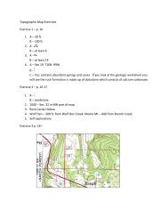
Topographic Map Exercises<br />
Exercise 1<br />
Refer to the Melbourne Topographic Quadrangle <strong>and</strong> Geologic Worksheet to answer<br />
the follow<strong>in</strong>g questions.<br />
1. Determ<strong>in</strong>e the follow<strong>in</strong>g:<br />
A. Contour Interval____________________<br />
B. Elevation between Index Contours_______________________<br />
2. Locate a gravel pit:<br />
A. What is the map symbol for a gravel pit?______________________<br />
B. How many gravel pits do you see on the map?_________________<br />
3. Locate a spr<strong>in</strong>g:<br />
A. What is the map symbol for a spr<strong>in</strong>g?___________________________<br />
B. How many spr<strong>in</strong>gs do you see on the map?______________________<br />
4. Locate Melbourne Cave:<br />
A. What is the location <strong>in</strong> the L<strong>and</strong> Grid<br />
System?__________________________________________________<br />
B. What is the map symbol for a cave?_____________________________<br />
C. Does this quadrangle conta<strong>in</strong> karst topography?____________________<br />
Why?______________________________________________________<br />
___________________________________________________________<br />
___________________________________________________________<br />
Exercise 2<br />
Refer to the Guion Topographic Quadrangle <strong>and</strong> Geologic Worksheet to answer the<br />
follow<strong>in</strong>g questions.<br />
1. Locate the m<strong>in</strong>es <strong>in</strong> the town of Guion:<br />
A. What is the map symbol for a m<strong>in</strong>e?_________________________________<br />
B. What is be<strong>in</strong>g m<strong>in</strong>ed?____________________________________________<br />
2. What is the highest elevation on the map?_______________________________<br />
3. Which is the steeper dra<strong>in</strong>age?<br />
Rock Castle Hollow or Beckham Hollow<br />
16
4. What is the Relief of these two mounta<strong>in</strong>s?<br />
Wolf Den Mounta<strong>in</strong>____________________________________________<br />
Meeks Mounta<strong>in</strong>______________________________________________<br />
5. Create a topographic profile across Fort Mounta<strong>in</strong> from A-A’ (see full size map for<br />
more details).<br />
17
Exercise 3<br />
The map below conta<strong>in</strong>s contour l<strong>in</strong>es that represent depressions or s<strong>in</strong>k holes.<br />
The contour <strong>in</strong>terval is 20 feet. A couple of elevations are shown at 1200 <strong>and</strong><br />
1300 feet. Use st<strong>and</strong>ard contour <strong>in</strong>tervals to fill <strong>in</strong> the correct elevations for the<br />
contour l<strong>in</strong>es.<br />
18
Interpretation of streams <strong>and</strong> l<strong>and</strong>forms<br />
Topographic maps allow users to exam<strong>in</strong>e large areas of the earth’s surface.<br />
Streams <strong>and</strong> l<strong>and</strong>forms as well as geologic structures are more easily viewed for<br />
geologic <strong>in</strong>terpretation.<br />
In this exercise we are go<strong>in</strong>g to <strong>in</strong>vestigate streams <strong>and</strong> their dra<strong>in</strong>age patterns<br />
<strong>and</strong> l<strong>and</strong>forms <strong>and</strong> learn about the geologic processes that formed them.<br />
All def<strong>in</strong>itions are from the Glossary of Geology, 1987.<br />
Flood pla<strong>in</strong> – The surface or strip of relatively smooth l<strong>and</strong> adjacent to a river<br />
channel constructed by the present river <strong>in</strong> its exist<strong>in</strong>g regimen <strong>and</strong> covered with<br />
water when the river overflows its banks. It is built of alluvium carried by the river<br />
dur<strong>in</strong>g floods <strong>and</strong> deposited <strong>in</strong> the sluggish water beyond the <strong>in</strong>fluence of the<br />
swiftest current. A river has one flood pla<strong>in</strong> <strong>and</strong> may have one or more terraces<br />
represent<strong>in</strong>g ab<strong>and</strong>oned flood pla<strong>in</strong>s.<br />
The map above shows the Buffalo River at Tyler Bend. The flood pla<strong>in</strong> is colored<br />
<strong>in</strong> yellow. Notice the elevation of the floodpla<strong>in</strong> compared to the surround<strong>in</strong>g<br />
terra<strong>in</strong>.<br />
19
Gradient – A degree of <strong>in</strong>cl<strong>in</strong>ation or rate of ascent or descent. The gradient of a<br />
stream is the steepness of the slope on which the stream flows. It is expressed<br />
as a ratio <strong>and</strong> measured <strong>in</strong> feet of fall per mile of travel. To determ<strong>in</strong>e the<br />
gradient of a stream first measure the distance of the stream <strong>in</strong> miles. Next<br />
determ<strong>in</strong>e the difference <strong>in</strong> elevation (feet) between the headwaters of the<br />
stream <strong>and</strong> the end<strong>in</strong>g of the stream. Divide the length of the stream <strong>in</strong> miles by<br />
the total number of feet.<br />
From the map we will<br />
calculate the gradient of<br />
Trace Creek. First measure<br />
the distance from the<br />
headwaters to Big P<strong>in</strong>ey<br />
Creek. Use a str<strong>in</strong>g to<br />
measure off the mileage.<br />
The creek mileage is<br />
approximately 3 miles. Next<br />
subtract the elevation at Big<br />
P<strong>in</strong>ey Creek from the higher<br />
elevation <strong>in</strong> the headwaters.<br />
The difference <strong>in</strong> elevation<br />
from the headwaters to the<br />
Big P<strong>in</strong>ey is 680 feet.<br />
Therefore 680/3 = 227 ft per<br />
mile. We now know that<br />
Trace Creek descends 680<br />
feet over a distance of 3<br />
miles or 227 ft per mile.<br />
20
Me<strong>and</strong>er<strong>in</strong>g stream – A mature stream that sw<strong>in</strong>gs from side to side as it flows<br />
across its flood pla<strong>in</strong> or shifts its course. A me<strong>and</strong>er<strong>in</strong>g stream develops s<strong>in</strong>uous<br />
curves, bends, loops, turns, or w<strong>in</strong>d<strong>in</strong>gs. A stream hav<strong>in</strong>g a pattern of<br />
successive me<strong>and</strong>ers.<br />
21
V-shaped valley – A valley hav<strong>in</strong>g a pronounced cross profile suggest<strong>in</strong>g the<br />
form of the letter “V”, characterized by steep sides <strong>and</strong> short tributaries; specif. a<br />
young, narrow valley result<strong>in</strong>g from downcutt<strong>in</strong>g by a stream. The “V” becomes<br />
broader as the amount of mass wast<strong>in</strong>g <strong>in</strong>creases.<br />
This map shows an excellent<br />
example of a v-shaped valley.<br />
Notice the steep sides,<br />
approximately 300-400 feet of<br />
relief, <strong>and</strong> the short tributaries.<br />
Alum Cave Canyon is located<br />
near Alread <strong>Arkansas</strong> <strong>in</strong> the Ozark<br />
Plateaus Region.<br />
Imag<strong>in</strong>e a topographic profile from<br />
west to east across the canyon.<br />
22
Stream Dra<strong>in</strong>age Patterns<br />
Vary<strong>in</strong>g stream patterns develop accord<strong>in</strong>g to the underly<strong>in</strong>g geology of an area.<br />
By familiariz<strong>in</strong>g oneself with the different patterns a quick look at streams will<br />
allow for easier <strong>in</strong>terpretation of the evolution of a l<strong>and</strong>scape. The figure above<br />
shows the major stream dra<strong>in</strong>age patterns observed <strong>in</strong> map view. The most<br />
common dra<strong>in</strong>age pattern is dendritic, resembl<strong>in</strong>g the branches of a tree or root<br />
system. This dra<strong>in</strong>age pattern is typical of streams that develop <strong>in</strong> regions<br />
underla<strong>in</strong> by relatively flat-ly<strong>in</strong>g or uniformly eroded sedimentary rock. A trellis<br />
pattern will result where rocks have been folded <strong>and</strong> bent <strong>in</strong>to long folds <strong>and</strong><br />
eroded <strong>in</strong>to resistant ridges <strong>and</strong> valleys. A me<strong>and</strong>er<strong>in</strong>g stream develops <strong>in</strong> areas<br />
of relatively low relief.<br />
L<strong>and</strong>forms<br />
The l<strong>and</strong>scapes that we see around us today were formed first by geologic forces<br />
<strong>in</strong> the past <strong>and</strong> from erosion <strong>and</strong> weather<strong>in</strong>g by water, w<strong>in</strong>d <strong>and</strong> ice, that<br />
cont<strong>in</strong>ues today. The steepness of hillsides <strong>and</strong> gradient of rivers are controlled<br />
by the erosional resistance of the underly<strong>in</strong>g rock. Generally speak<strong>in</strong>g<br />
s<strong>and</strong>stone is more resistant to weather<strong>in</strong>g <strong>and</strong> erosion than shale or limestone.<br />
Shale tends to form more gentle slopes <strong>and</strong> valleys where s<strong>and</strong>stone forms the<br />
caprock of hills <strong>and</strong> produce steep slopes. The figure below illustrates how the<br />
erosional resistance <strong>and</strong> orientation of rock layers controls the formation of<br />
l<strong>and</strong>forms.<br />
23
L<strong>and</strong>form def<strong>in</strong>itions (Glossary of Geology, 1987)<br />
Butte – a conspicuous, usually isolated, generally flat-topped hill or small<br />
mounta<strong>in</strong> with relatively steep slopes or precipitous cliffs, often capped with a<br />
resistant layer of rock <strong>and</strong> bordered by talus <strong>and</strong> represent<strong>in</strong>g an erosion<br />
remnant carved from flat-ly<strong>in</strong>g rocks; the summit is smaller <strong>in</strong> extent than that of<br />
a mesa.<br />
Cuesta – a hill or ridge with a gentle slope on one side <strong>and</strong> a steep slope on the<br />
other; an asymmetric ridge; the formation of the ridge be<strong>in</strong>g controlled by the<br />
differential erosion of the gently <strong>in</strong>cl<strong>in</strong>ed strata.<br />
Escarpment – a long more or less cont<strong>in</strong>uous cliff or relatively steep slope fac<strong>in</strong>g<br />
<strong>in</strong> one general direction, break<strong>in</strong>g the cont<strong>in</strong>uity of the l<strong>and</strong> by separat<strong>in</strong>g two<br />
level or gently slop<strong>in</strong>g surfaces <strong>and</strong> produced by erosion or by fault<strong>in</strong>g.<br />
Hogback – any ridge with a sharp summit <strong>and</strong> steep slopes of nearly equal<br />
<strong>in</strong>cl<strong>in</strong>ation on both flanks, <strong>and</strong> resembl<strong>in</strong>g <strong>in</strong> outl<strong>in</strong>e the back of a hog; specifically<br />
a sharp-crested ridge formed by the outcropp<strong>in</strong>g edges of steeply <strong>in</strong>cl<strong>in</strong>ed<br />
resistant rocks <strong>and</strong> produced by differential erosion.<br />
Plateau - Plateaus – Broadly, any comparatively flat area of great extent <strong>and</strong><br />
elevation; specif. an extensive l<strong>and</strong> region considerably elevated (more than 150-<br />
300 m <strong>in</strong> altitude) above the adjacent country or above sea level; it is commonly<br />
limited on at least one side by an abrupt descent, has a flat or nearly smooth<br />
surface but is often dissected by deep valleys <strong>and</strong> surmounted by high hills or<br />
mounta<strong>in</strong>s <strong>and</strong> has a large part of its total surface at or near the summit level. A<br />
plateau is usually higher <strong>and</strong> has a more noticeable relief than a pla<strong>in</strong>.<br />
References:<br />
Vanarsdale, Roy, 1991, Geologic <strong>in</strong>terpretation of remote sensor imagery <strong>and</strong><br />
Topographic maps, <strong>in</strong> Methods <strong>and</strong> Practices of Physical Geology,<br />
Third Edition, by Konig <strong>and</strong> Zachry, Jr., University of <strong>Arkansas</strong>.<br />
25
Exercise 1 (Refer to Moore Quadrangle)<br />
Calculate the gradient of Long Devils Fork from its headwaters to its confluence<br />
with big Devils Fork <strong>in</strong> the western portion of the quadrangle.<br />
Calculate the distance of the stream____________________________<br />
Calculate the elevation difference______________________________<br />
Gradient__________________________________________________<br />
Do you expect this stream to have waterfalls?_____________________<br />
Compare the floodpla<strong>in</strong> of both Devils Forks to the floodpla<strong>in</strong> of Richl<strong>and</strong> Creek.<br />
What is the difference <strong>and</strong> why?________________________________<br />
Exercise 2 (Refer to Beaver Quad)<br />
Which dra<strong>in</strong>age pattern is present <strong>in</strong> the southern portion of this quadrangle?<br />
What can you <strong>in</strong>fer about the underly<strong>in</strong>g geology of this region?<br />
Exercise 3 (Refer to Nichols Mounta<strong>in</strong> Quadrangle)<br />
Which dra<strong>in</strong>age pattern is represented on this<br />
quadrangle?______________________________________________________<br />
Why is this?_______________________________________________________<br />
Exercise 4 (Refer to De Valls Bluff Quadrangle)<br />
Calculate the gradient of the White River from the northern edge of the<br />
quadrangle to the southern edge of the quadrangle.<br />
Calculate the distance____________________________________________<br />
Calculate the difference <strong>in</strong> elevation_________________________________<br />
Calculate the gradient_____________________________________________<br />
26
Compare the gradient of the White River with the gradient of Long Devils Fork<br />
from Exercise 1.<br />
What is the difference <strong>and</strong> why?_____________________________________<br />
______________________________________________________________<br />
In which physiographic regions are each stream located?___________________<br />
_______________________________________________________________<br />
Exercise 5 (Refer to Casa Quadrangle)<br />
Look at Cove Mounta<strong>in</strong> <strong>and</strong> Rose Creek Mounta<strong>in</strong>. Observe the shape of the<br />
mounta<strong>in</strong>s <strong>and</strong> answer the questions below.<br />
Which side of the mounta<strong>in</strong> is the steepest?____________________________<br />
Is this feature shaped like a canoe upside down or right side up?____________<br />
Exam<strong>in</strong>e the dra<strong>in</strong>ages south of Cove Mounta<strong>in</strong> <strong>and</strong> north of Rose Creek<br />
Mounta<strong>in</strong>. Which direction can we <strong>in</strong>fer that the rock is dipp<strong>in</strong>g?_____________<br />
Which geologic structure would this be? Anticl<strong>in</strong>e or syncl<strong>in</strong>e?_______________<br />
________________________________________________________________<br />
Exercise 6 (Refer to Caddo Valley Quadrangle)<br />
Compare the l<strong>and</strong>forms <strong>and</strong> stream pattern on the northwestern portion of the<br />
quadrangle to those on the southeastern portion of the quadrangle.<br />
Imag<strong>in</strong>e a l<strong>in</strong>e separat<strong>in</strong>g the two different regions. Which physiographic regions<br />
are represented <strong>in</strong> this quadrangle?<br />
________________________________________________________________<br />
27
Exercise 7 (Refer to Perryville Quadrangle)<br />
Compare the streams <strong>and</strong> l<strong>and</strong>forms <strong>in</strong> the northern part of the map to those <strong>in</strong><br />
the southern part of the map.<br />
Imag<strong>in</strong>e a l<strong>in</strong>e separat<strong>in</strong>g the two different regions along Highway 10 runn<strong>in</strong>g<br />
east to west. Which physiographic regions are represented on this quadrangle?<br />
________________________________________________________________<br />
Exercise 8 (Refer to l<strong>and</strong>forms diagram <strong>and</strong> Prairie Grove Quadrangle)<br />
Compare the l<strong>and</strong>forms <strong>in</strong> the northwest portion of the quadrangle to the small<br />
hill south of Prairie Grove <strong>and</strong> to Stevenson Mounta<strong>in</strong>.<br />
Which l<strong>and</strong>form names can be applied to these hills?<br />
________________________________________________________________<br />
What can you <strong>in</strong>fer from the l<strong>and</strong>forms <strong>and</strong> the stream pattern?<br />
Exercise 9 (Refer to l<strong>and</strong>forms diagram <strong>and</strong> Ferndale Quadrangle)<br />
Exam<strong>in</strong>e the ridge created by Brush Mounta<strong>in</strong> <strong>in</strong> the southern portion of the<br />
quadrangle. Notice the steepness of both sides of the ridge.<br />
Which l<strong>and</strong>form name can be applied to this ridge?________________________<br />
What can you <strong>in</strong>fer from these features <strong>and</strong> the stream pattern?______________<br />
28
Exercise 10 (Refer to l<strong>and</strong>forms diagram <strong>and</strong> Rich Mounta<strong>in</strong> Quadrangle)<br />
Exam<strong>in</strong>e Rich Mounta<strong>in</strong>. Follow Highway 88 (Skyl<strong>in</strong>e Drive) <strong>and</strong> notice the<br />
steepness on both sides of the ridge.<br />
Which l<strong>and</strong>form name can be applied to this ridge?________________________<br />
In which physiographic region is the feature located? _____________________<br />
________________________<br />
29
Geologic Map<br />
of<br />
<strong>Arkansas</strong><br />
Quaternary<br />
Tertiary<br />
Igneous<br />
Cretaceous<br />
Pennsylvanian<br />
Mississippian<br />
Silurian/Devonian<br />
<strong>in</strong>cludes middle <strong>and</strong> upper<br />
division of Mississippian<br />
<strong>Arkansas</strong> Novaculite<br />
Silurian/Devonian<br />
Ordovician<br />
Cambrian<br />
<strong>in</strong>cludes portions of Lower<br />
Ordovician Collier Shale<br />
30<br />
0 35 70 140 Miles
Geologic Time Scale<br />
0<br />
50<br />
Era<br />
Cenozoic<br />
Period<br />
Quaternary 1.8<br />
Tertiary 65<br />
100<br />
Cretaceous<br />
144<br />
Millions of Years<br />
150<br />
200<br />
250<br />
300<br />
350<br />
Mesozoic<br />
Jurassic<br />
Triassic<br />
Permian<br />
Pennsylvanian<br />
Mississippian<br />
206<br />
248<br />
290<br />
323<br />
354<br />
400<br />
Paleozoic<br />
Devonian<br />
417<br />
450<br />
Silurian<br />
Ordovician<br />
443<br />
490<br />
500<br />
Cambrian<br />
543<br />
540<br />
Proterozoic<br />
Precambrian<br />
2.5 billion years ago<br />
Archean<br />
Based on 1999 Geologic Time Scale<br />
<strong>Geological</strong> Society of America<br />
32