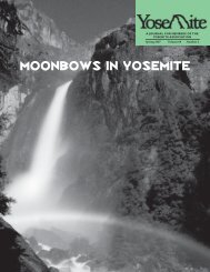
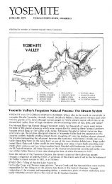
The Geography and Dialects of the Miwok Indians - Yosemite Online
The Geography and Dialects of the Miwok Indians - Yosemite Online
The Geography and Dialects of the Miwok Indians - Yosemite Online

Create successful ePaper yourself
Turn your PDF publications into a flip-book with our unique Google optimized e-Paper software.
348 University <strong>of</strong> California Publications in Am. Arch. <strong>and</strong> Ethn. [Vol . 6<br />
territory. <strong>The</strong> same conditions apparently did not obtain immediately<br />
to <strong>the</strong> south <strong>of</strong> this region. <strong>The</strong>re was hostility between<br />
<strong>the</strong> <strong>Miwok</strong> <strong>and</strong> <strong>the</strong> Shoshonean "Paiutes " along <strong>the</strong> portion<br />
<strong>of</strong> <strong>the</strong>ir boundary line at <strong>the</strong> sou<strong>the</strong>rn head <strong>of</strong> Stanislaus<br />
river, although still far<strong>the</strong>r to <strong>the</strong> south, in <strong>the</strong> vicinity <strong>of</strong><br />
<strong>Yosemite</strong> valley <strong>and</strong> southward, <strong>the</strong> people <strong>of</strong> <strong>the</strong> two stocks were<br />
on very friendly terms, making amicable trading trips both ways<br />
across <strong>the</strong> summit <strong>of</strong> <strong>the</strong> Sierras.<br />
At Mt. Lyell <strong>the</strong> boundary turns in a southwesterly direction<br />
<strong>and</strong> follows <strong>the</strong> divide between <strong>the</strong> headwaters <strong>of</strong> San Joaquin<br />
<strong>and</strong> Merced rivers to <strong>the</strong> head <strong>of</strong> Fresno river. It <strong>the</strong>n follows,<br />
in a general way, <strong>the</strong> course <strong>of</strong> this stream with its nor<strong>the</strong>asterly<br />
<strong>and</strong> southwesterly trend down, at least, to a point a few miles<br />
west <strong>of</strong> Fresno Flat. Here it probably makes a slight swing to<br />
<strong>the</strong> south to include <strong>the</strong> vicinity <strong>of</strong> what was formerly known as<br />
Fresno Crossing, <strong>the</strong>n returns to <strong>the</strong> river itself <strong>and</strong> continues<br />
down it to a point about due south <strong>of</strong> Raymond . <strong>The</strong> nor<strong>the</strong>astern<br />
part <strong>of</strong> this portion <strong>of</strong> <strong>the</strong> boundary separates <strong>Miwok</strong><br />
from Shoshonean territory, while <strong>the</strong> southwestern part separates<br />
it from Yokuts territory. <strong>The</strong>re is a possible deviation from <strong>the</strong><br />
sou<strong>the</strong>rn boundary as here given, in <strong>the</strong> vicinity <strong>of</strong> Ahwahnee.<br />
According to certain informants <strong>the</strong> boundary left <strong>the</strong> river here<br />
<strong>and</strong> ran for a short distance to <strong>the</strong> north, including Ahwahnee<br />
<strong>and</strong> vicinity in Yokuts territory . However, <strong>the</strong> bulk <strong>of</strong> <strong>the</strong> information<br />
obtained places Ahwahnee in <strong>Miwok</strong> territory <strong>and</strong><br />
runs <strong>the</strong> boundary between <strong>the</strong> <strong>Miwok</strong> <strong>and</strong> Yokuts directly on<br />
Fresno river itself, except, as above mentioned, where it swings to<br />
<strong>the</strong> south to include <strong>the</strong> vicinity <strong>of</strong> Fresno Crossing, at which<br />
point it was asserted by both <strong>Miwok</strong> <strong>and</strong> Yokuts informants that<br />
<strong>the</strong> <strong>Miwok</strong> occupied both banks <strong>of</strong> <strong>the</strong> river for a few miles.<br />
<strong>The</strong> western boundary <strong>of</strong> <strong>the</strong> <strong>Miwok</strong> territory is not as yet<br />
absolutely settled, but according to <strong>the</strong> best information obtainable<br />
it follows <strong>the</strong> western edge <strong>of</strong> <strong>the</strong> foot-hill region—<strong>the</strong> actual<br />
meeting place <strong>of</strong> <strong>the</strong> broad plain <strong>of</strong> <strong>the</strong> San Joaquin valley with<br />
<strong>the</strong> foot-hills <strong>the</strong>mselves—from <strong>the</strong> point above mentioned on<br />
Fresno river south <strong>of</strong> Raymond, to Calaveras river, down which<br />
stream it runs to a point a few miles nor<strong>the</strong>ast <strong>of</strong> Stockton.<br />
Here it turns in a general northwesterly direction <strong>and</strong> follows <strong>the</strong>
![(March 1982) [PDF] “We Are Pleased to Announce†- Yosemite Online](https://img.yumpu.com/51299748/1/190x242/march-1982-pdf-aeuroewe-are-pleased-to-announceaeur-yosemite-online.jpg?quality=85)
![[PDF] Old Horny, Yosemite's Unicorn Buck - Yosemite Online](https://img.yumpu.com/51269869/1/184x260/pdf-old-horny-yosemites-unicorn-buck-yosemite-online.jpg?quality=85)
![1985 [PDF] - Yosemite](https://img.yumpu.com/48128837/1/184x260/1985-pdf-yosemite.jpg?quality=85)